COUNCIL AGENDA
ADDENDUM BOOKLET
Ordinary Council Meeting
22 February 2017
FRANCIS GREENWAY CENTRE
COUNCIL AGENDA
ADDENDUM BOOKLET
Ordinary Council Meeting
22 February 2017
FRANCIS GREENWAY CENTRE
![]()
Addendum Items
PAGE TAB
Planning and Growth Report
DPG 03 Planning Proposal for Lot 1 Governor Macquarie Drive, Warwick Farm rezoning from B5 Business Zone to R4 High Density Residential Zone................................... 192......... 1
Chief Executive Officer Report
CEO 01 Draft Community Strategic Plan.................................................................. 279......... 2
CEO 02 Strategic Panel Minutes 13 February 2017.................................................. 313......... 3
Chief Financial Officer
CFO 03 Minutes of Budget Review Panel 9 February 2017...................................... 320......... 4
193
Ordinary Meeting 22 February 2017
Planning and Growth Report
|
DPG 03 |
Planning Proposal for Lot 1 Governor Macquarie Drive, Warwick Farm rezoning from B5 Business Zone to R4 High Density Residential Zone |
|
Strategic Direction |
Liveable Safe City Deliver an efficient planning system which embraces sustainable urban renewal and development |
|
Key Policy |
Urban Development Plans |
|
File Ref |
028756.2017 |
|
Report By |
Toni Averay - Director Planning & Growth |
|
Approved By |
Kiersten Fishburn - Chief Executive Officer |
|
Property |
Lot 1 Governor Macquarie Drive |
|
Owner |
Hydrox Nominees Pty Ltd |
|
Applicant |
Warwick Farm Village Pty Ltd |
Executive Summary
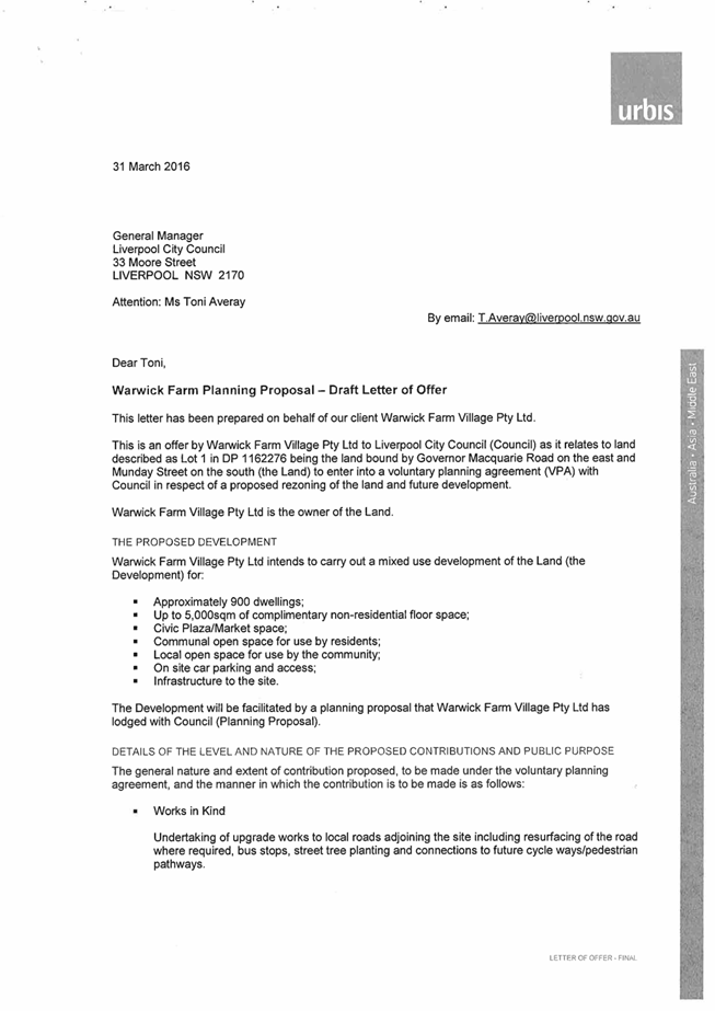
This report details the planning proposal submitted by Warwick Farm Villages Pty Ltd for Lot 1 Governor Macquarie Drive, Warwick Farm (Lot 1 DP 1162276), and recommends Council support a reduced residential density with a maximum floor space ratio (FSR) of 2:1 which equates to approximately 500 residential dwelling units. Subject to the applicant providing a modified planning proposal reflecting the reduced density, it is recommended the CEO be delegated authority to finalise the planning proposal and submit to DPE for Gateway approval.
The planning proposal as submitted seeks to amend the Liverpool Local Environment Plan (LLEP) 2008 to rezone the site from B5 Business Development to part R4 High Density Residential and part B4 Mixed Use with associated modifications to the FSR from 0.75:1 to 3.5:1 and height of building (HOB) from 15m to part 45m and part 100m.
The planning proposal as submitted by the applicant would facilitate development of the subject site on a scale of approximately 950 residential units in apartment block-form ranging up to 30 storeys and include up to 5000sqm of retail floor area.
Council’s Planning and Development Committee discussed the planning proposal at its meeting on 7 December 2016, where three options were considered:
1. Reject the planning proposal as submitted on planning grounds because the proposal lacks strategic or site specific merit; or
2. Defer consideration of the planning proposal until Council has adopted a broader precinct-wide strategy for Warwick Farm: or
3. Request a modified planning proposal with a reduced FSR of 2:1 which equates to approximately 500 residential apartments.
This report recommends Council support Option 3.
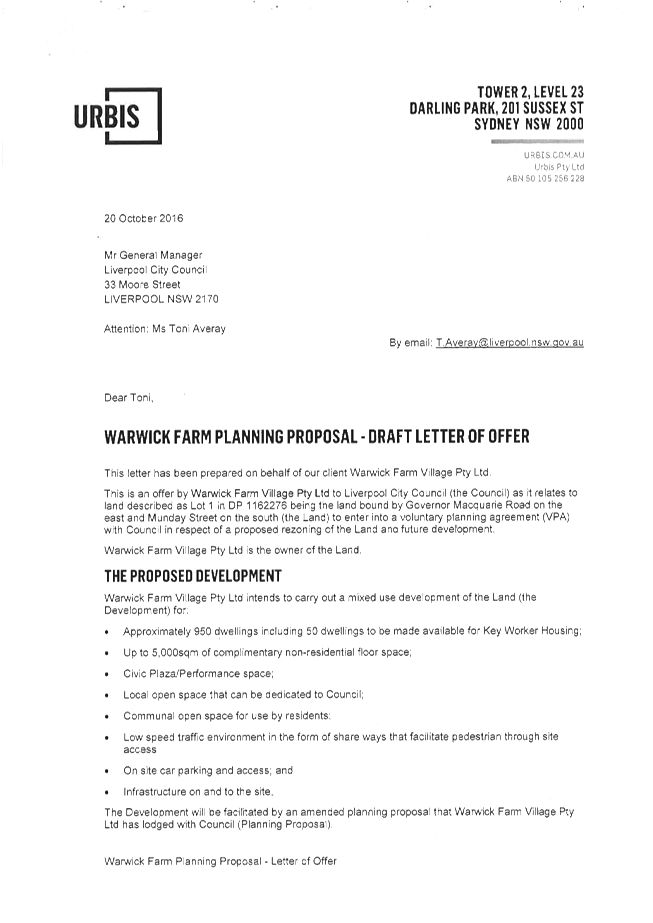
The applicants have been in discussion with Council officers regarding the subject planning proposal since May 2015. In response to feedback from Council officers during this time, the applicants have revised the proposed residential density from approximately 1400 residential units when discussions first commenced, to the current 950. The applicants have also undertaken a range of supporting studies, including a comprehensive social impact assessment. The planning proposal was formally lodged on 11 November 2015.
Traffic and transport impacts are the most important and complex considerations in the assessment of this planning proposal. Council officers and RMS and TfNSW officers are currently unable to support the proposed residential density in the absence of broader planning and regional traffic upgrades. However, Council’s traffic assessment is that a level of development similar to the density west of the Warwick Farm Station can be supported at this time, noting that the applicant proposes a VPA to make a significant contribution to the construction of a bypass road. The bypass road is essential to resolve the long standing traffic and land use conflicts which exist in this area and has been the subject of representations from residents over several years. The bypass road is discussed in more detail in this report.
A reduced density with an FSR of 2:1 which equates to approximately 500 residential apartments would be consistent with the level of other R4 development close to the development site and would also reduce the social impacts of the proposed development. Detailed traffic and flood modelling are recommended to be conditioned as part of a Gateway approval.
The proposed development provides the opportunity to deliver approximately 500 new dwellings, including approximately 25 key worker dwellings, within 5 minutes’ walk of a railway station connecting to regional transport services. The acceleration of housing supply is one of the top priorities for the NSW State Government. The draft amendment to A Plan for Growing Sydney released in November 2016 notes that Councils are in the best position to investigate opportunities for medium density housing in urban renewal precincts within 1-5 kilometres of regional transport.
The applicant has also proposed to enter into a VPA to contribute to the construction of the Warwick Farm bypass road. The Warwick Farm area is undergoing significant change with ATC developments and GMD upgrade works underway. Council officers propose to undertake a dedicated master planning exercise for the area as part of the current LEP review but planning is in the early stages. A precinct plan will enable a strategic and collaborative approach to the development of the broader Warwick Farm precinct, consistent with the Draft South West District Plan. The future precinct plan will ensure that the current land use conflicts are resolved and will address amenity outcomes for residents and businesses in the locality as a whole. It is considered that a modified planning proposal of 500 units can be supported and can progress concurrently with the broader precinct planning work.
Preliminary discussions have been held with DPE on this report and the recommendations. DPE officers have expressed in principle support for the recommended approach.
A report on the proposed Strategic Framework for the LEP review will be finalised for the March Council meeting and will include discussion on the proposed Warwick Farm precinct plan.
|
That Council:
1. Endorses in principle the planning proposal for Lot 1 Governor Macquarie Drive, Warwick Farm, subject to the applicant submitting a modified proposal with a maximum floor space ratio (FSR) of 2:1 which equates to approximately 500 residential dwelling units.
2. Delegates to the CEO the authority to finalise the modified planning proposal and submit to DPE for Gateway approval with a recommendation that detailed traffic and flood modelling be included as Gateway conditions;
3. Notes that the CEO will finalise negotiations regarding the proposed voluntary planning agreement and public benefit offer and any other relevant conditions as required to support the proposal, with a report to be presented to a future Council meeting;
4. Notes that funds will be sought in the capital program in the 2017/18 budget to progress land acquisitions for the bypass road; and
5. Notes that a report on a draft Warwick Farm precinct plan will be presented to the July 2017 Council meeting.
|
Report
Site Context
The subject property is located on Governor Macquarie Drive in Warwick Farm, approximately 1.5 kilometres north-east of Liverpool City Centre. It is a triangular site, 2.93 hectares in size, with frontages along Governor Macquarie Drive, Warwick and Munday Streets. Warwick Farm Train Station is located to the west of the site. The lot is currently vacant but with substantial tree cover.

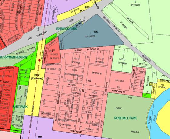
Figure 1: Planning Proposal Site at Lot 1 Governor Macquarie Drive highlighted in red border
The subject site is surrounded by a number of different land uses. The area immediately to south is largely low density residential and predominantly occupied by horse stables and training facilities associated with the Warwick Farm Racecourse, located immediately to the east, opposite Governor Macquarie Drive. To the west, next to Warwick Farm Train Station, is a small clustering of two storey town-homes. Also in proximity to the subject site is an industrial area, just south of the horse-training precinct, supporting operations such as Direct Freight, Visy and Liverpool Hospital’s bulk distribution facilities. Within the south-east section of this local area is situated Rosedale Oval and Sydney Water’s sewerage treatment facility.
Background
The subject site was previously part of the Australian Turf Club (ATC) Warwick Farm Racecourse landholding. To improve the racecourse facilities, the ATC underwent a rationalisation of their landholdings and disposed of residual land to assist in consolidating and financing upgrades to the racecourse and thoroughbred horse facilities.
LLEP 2008 Amendment No. 18 was gazetted on 9 December 2011 which rezoned the subject site from part RE2 Private Recreation and part R2 Low Density Residential to B5 Business Development. A VPA between the ATC and Council required upgrades to the intersection of Governor Macquarie Drive and Munday Street, including traffic lights to accommodate additional traffic volumes. The amendment was supported by Council on the grounds that there was a local and regional level demand for bulky goods retailing.
Following the LEP amendment, development consent was granted in February 2013 (DA-1321/2011) for a home improvement centre (a Masters development). However, the Woolworths Group has not developed the site but instead entered into contractual arrangements with the current applicant who is seeking to rezone the site to high density residential and mixed use. As a result, the site remains vacant.
The Planning Proposal
Warwick Farm Village Pty Ltd, initially lodged the planning proposal in November 2015. Council officers did not support the proposal which sought a 4.5:1 FSR, approximately 1400 residential units and 2,500sqm of retail floor space, and HOB of 100m or up to 30 storeys. Identified adverse impacts included the scale of the proposal, shadowing, traffic conflicts, existing land use conflicts and flooding constraints. The proponent subsequently revised the planning proposal and resubmitted it to Council in October 2016 – See Attachment A – the link to this document can be found on the following Council website page http://www.liverpool.nsw.gov.au/council/council-meetings#agendas
The revised proposal seeks the following:
· Rezone the site from B5 Business Development to part R4 High Density Residential and part B4 Mixed Use;
· Increase the HOB from 15m to part 45m and part 100m;
· Increase the FSR from 0.75:1 to 3.5:1 (facilitate approximately 950 residential apartments); and
· An additional use provision allowing up to 5,000sqm of retail floor space.
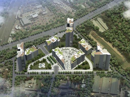
Figure 2: Planning Proposal Concept Design
Site Specific Merit
An assessment of potential impacts has been undertaken to determine the proposal’s site specific merit. The considerations for assessing the proposal include:
· Existing issues in Warwick Farm
· Suitability of high density residential
· Urban design
· Traffic and transport Impacts
· Social impacts
· Flooding impact
Existing Issues in Warwick Farm
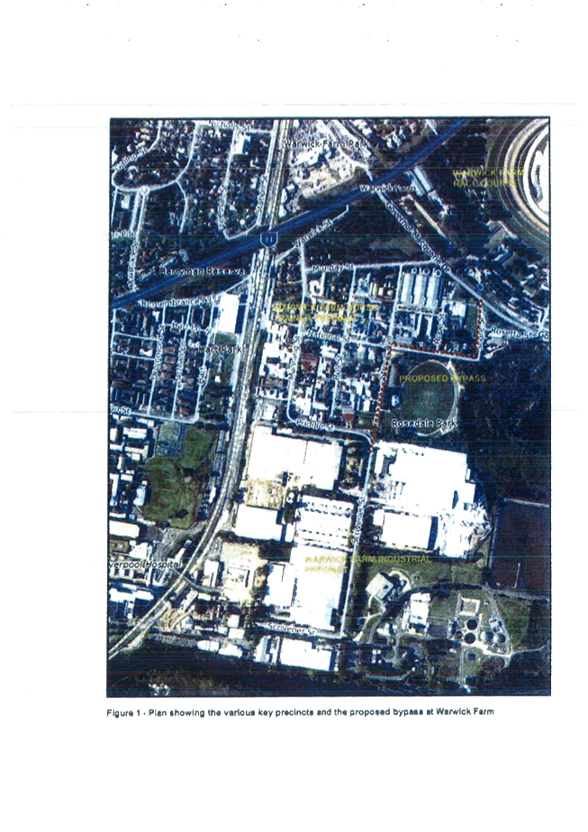
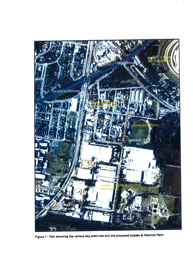
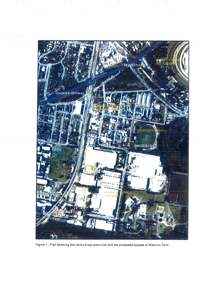
This area of Warwick Farm is unique because it accommodates a variety of conflicting land uses within a relatively small area. The land uses include low and medium density residential uses within the north and west sections; the equine-related activities supporting the Warwick Farm Racecourse that occupy the bulk of area, including the north, east and middle sections; the industrial, logistics and warehousing, operations to the south; and the regional waste treatment facility at the south-eastern edge of the precinct.
Given the number of competing priorities within this area and between stakeholders, Council undertook a review to determine the most appropriate way to resolve the land use conflicts (Figure 2). The Strategic Review of the Warwick Farm Horse Training Precinct was adopted by Council in June 2012. The purpose of this study was to gain an understanding of the complex issues surrounding the existing uses and the future development of this area of Warwick Farm. The review findings were as follows:
· There are significant challenges to reducing conflicts between residential, equestrian and industrial uses;
· Heavy vehicle movements, generating from the industrial area, significantly impact the established residential and horse training areas;
· There are severe constraints on the local and regional road network, creating significant traffic safety concerns, especially at the Munday Street intersection with Governor Macquarie Drive;
· The significant demand for on-street car parking on local roads close to Warwick Farm Train Station generates conflict;
· The area has poor pedestrian and cycle connectivity as a result of inadequate infrastructure;
· Safety of horses and trainers is an on-going concern;
· There is a lack of services and amenity for the residential community; and
· The Sewerage Treatment Facility impacted the amenity of the local area.
The Council resolved not to permit any increase in residential density within the area because it would exacerbate the existing conflicts identified.
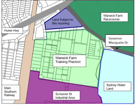
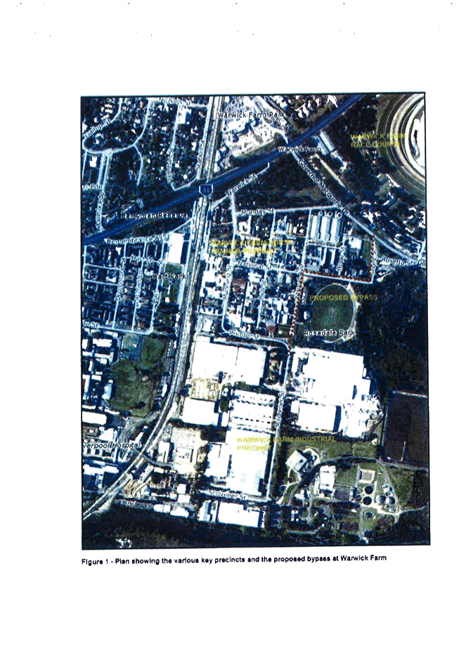
Figure 3: Precincts within Warwick Farm
It is noted that after the completion of the Strategic Review of the Warwick Farm Horse Training Precinct, there has been a number of approved development applications for industrial and equestrian uses. As of 2013, 19 development applications have been approved by Council:
· 5 development approvals within the Warwick Farm Industrial Precinct at a calculated cost of works of $610,000
· 14 development approvals within the Warwick Farm Horse Training Precinct at a calculated cost of works of $148,304,372
Existing B5 Business Development Zone on site
As noted above, LLEP 2008 Amendment No. 18 was gazetted on 9 December 2011, and the subject site was zoned B5 Business Development.
Council at the time considered the B5 Business Development zone to be the best use for the subject site, in consideration of the land use conflicts in the area. It was satisfied that there was sufficient demand for bulky goods retailing within the regional catchment and that the site was adequately connected to the regional road network, providing access for the consumer catchment and the enterprise corridors along Hume Highway and Cumberland Highway. Additionally, the subject property was able to provide a large floor plate required to bulky goods retailing.
Subsequently, the applicant determined that the proposed B5 development was no longer commercially viable and that it would not proceed.
Suitability of High Density Residential
As noted above, the subject site adjoins a number of non-residential land uses. It is also separated from other high density residential areas by the Warwick Farm railway station. By way of comparison, the northern edge of the Liverpool CBD in existing R4 areas has an FSR of 1.5:1-2:1 and a HOB of 35m-45m. The planning proposal as submitted is seeking a density (FSR) and building heights that that would be twice that of the northern edges of the Liverpool City Centre. When considering the urban context of the Liverpool CBD and the spatial hierarchy of the city, the scale of the proposed development in proximity to the CBD would undermine the predominance, legibility and orderly planning of Liverpool City Centre as a ‘strategic centre’.
The proposed reduced density of an FSR of 2:1 will result in a built form outcome which is more compatible with surrounding development and more appropriate in this location.
Currently Warwick Farm does not have a strategic framework to guide high density residential development and is also constrained in delivery of adequate infrastructure. Accordingly, it is considered that the proposed density should be reduced as detailed above.
Urban Design
The height and massing of the proposed development, currently out of character with the local area. The properties adjoining the subject site are predominantly low-scale 1-2 storey residential houses, with a substantial number supporting the equine-related activities.
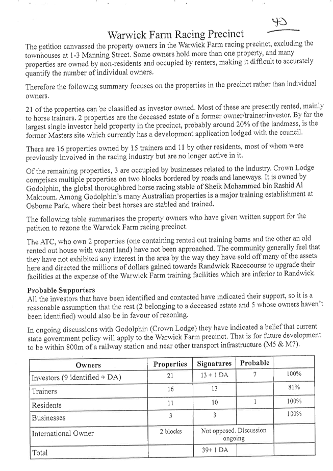
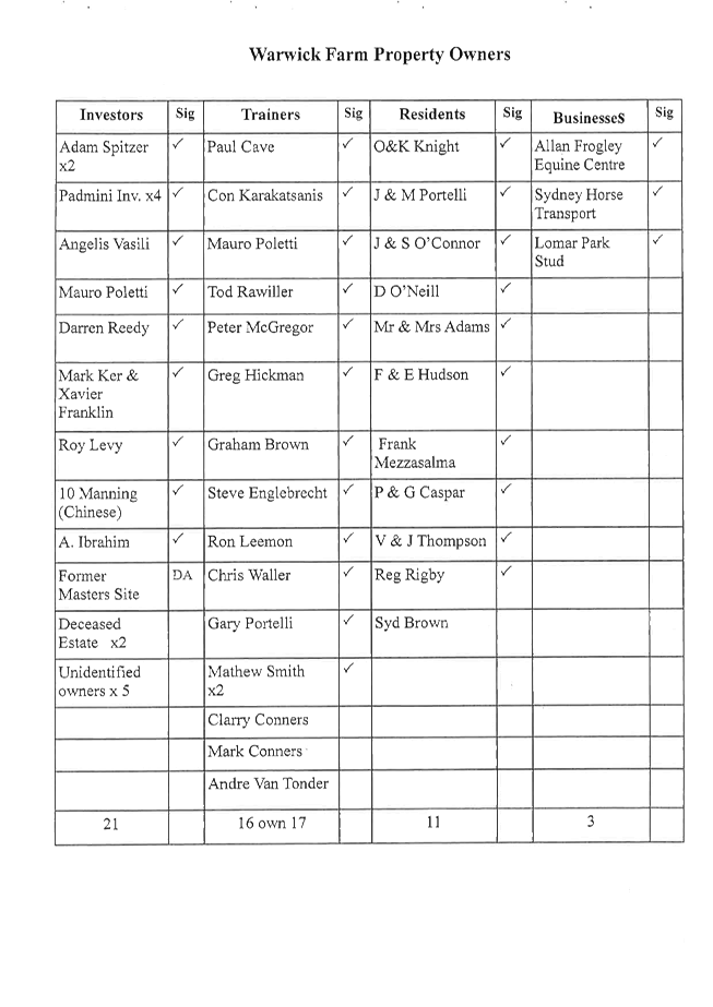
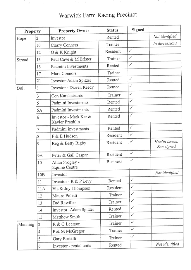
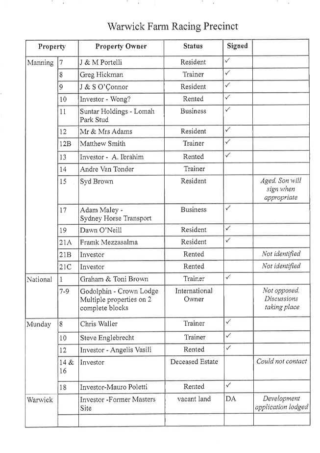
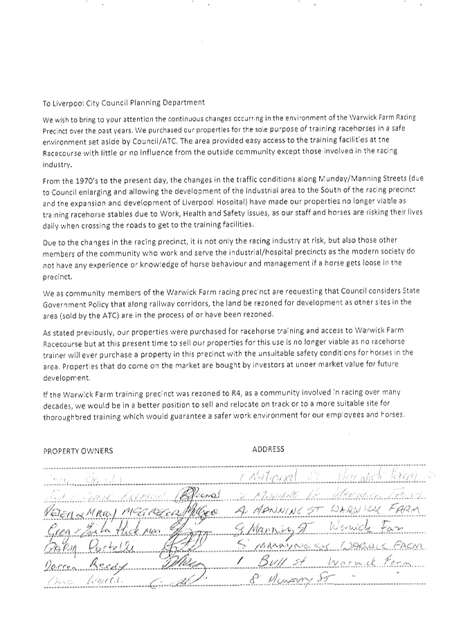
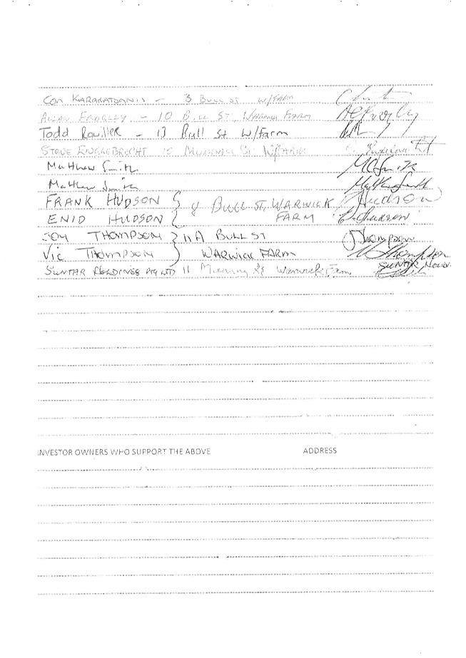
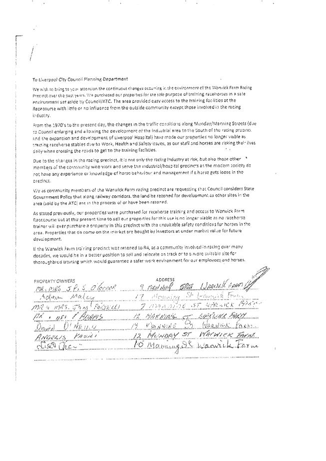
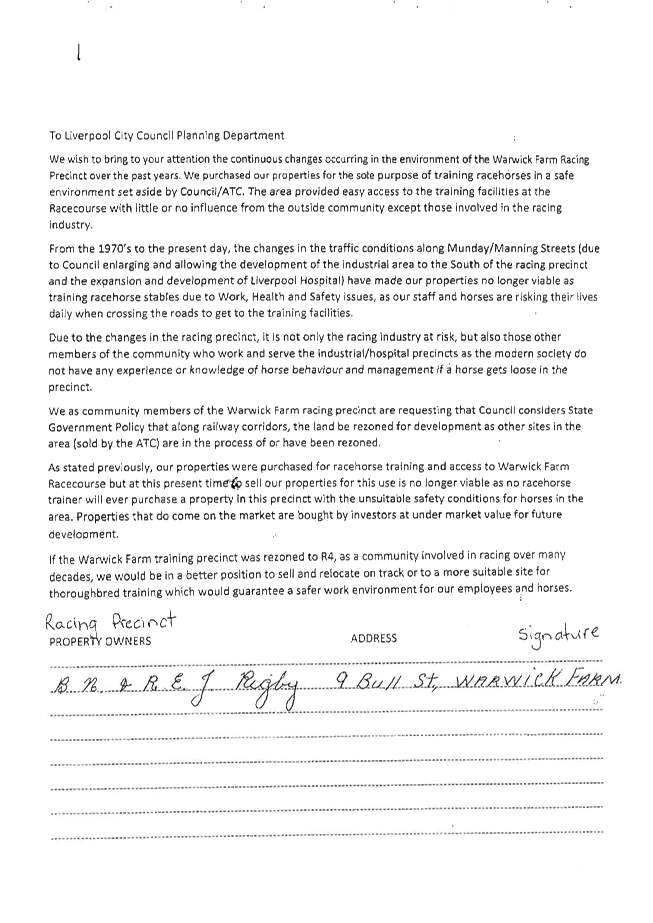
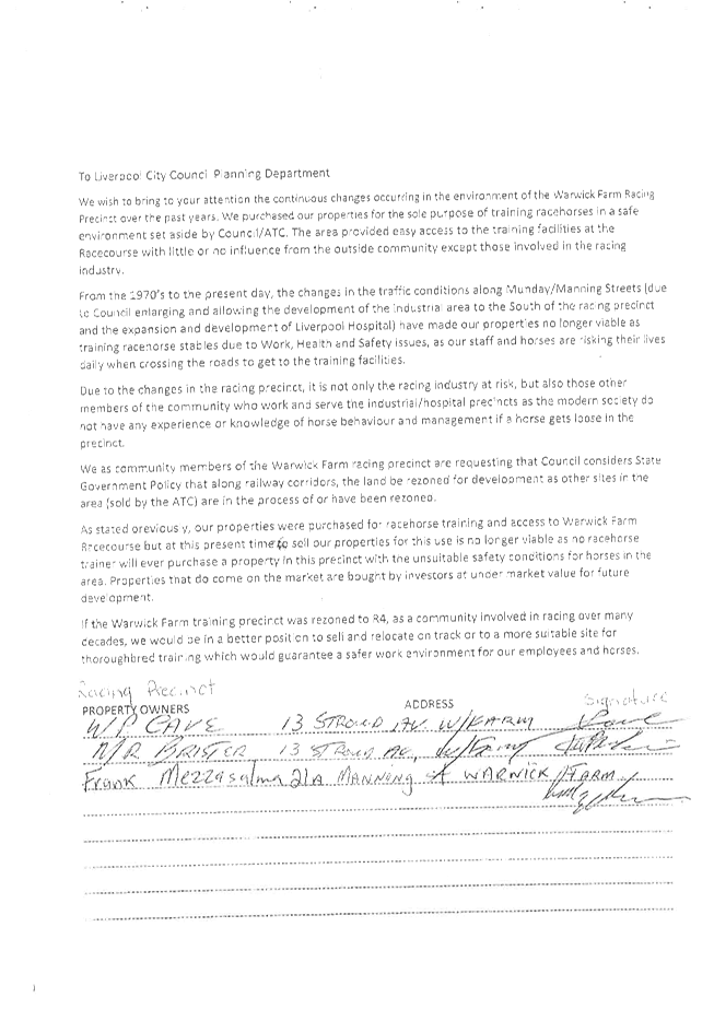
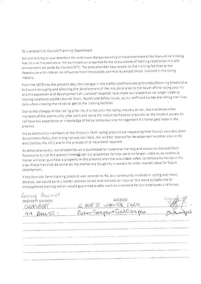
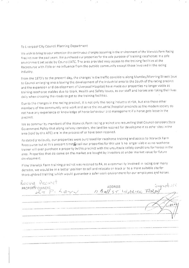
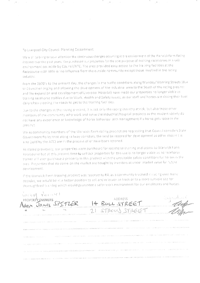
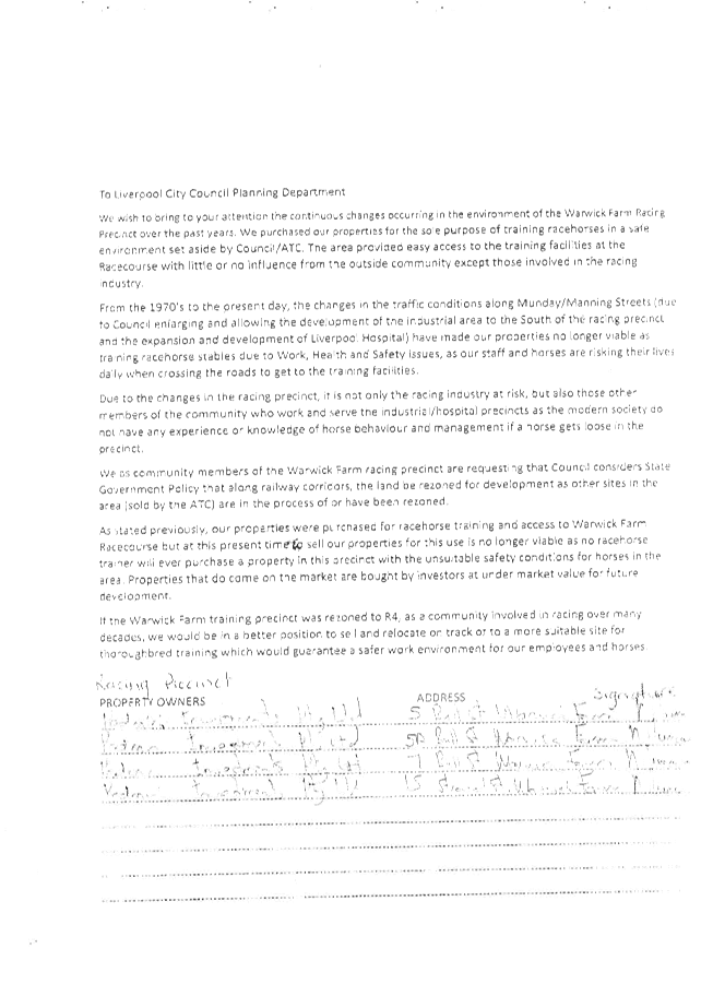
The precinct planning process is important to establish future land development patterns and uses. A petition by Warwick Farm residents seeking rezoning to R4 High Density Residential was submitted to Council in March 2016. The petition was signed by 39 Warwick Farm equestrian precinct property owners. Council received further representations from a number of residents in December 2016 supporting the subject planning proposal and urging Council to progress the rezoning of the broader precinct.
The concept plan submitted by the application lacks sufficient justification for this level of density in this area, noting the existing context of the place and likelihood of adverse visual and overshadowing impacts on the adjoining properties. This further supports the officer recommendation for the proposed density of the proposal to be reduced.
The proposal states that compliance in respect of privacy and overshadowing will be demonstrated as part of any future development application which will address the SEPP 65 Design Quality of Residential Flat Buildings.
The subject site and Warwick Farm are not part of Liverpool City Centre, which is identified in regional and sub-regional plans as a ‘strategic centre’. Warwick Farm is not supported by an adequate level of social or physical infrastructure to provide services and amenities required to sustain the level of density as proposed. The scale of the proposed development, is not sympathetic to the local environment and could undermine Liverpool City Centre’s strategic placement as a key centre in Sydney’s southwest. It is recommended a reduced FSR of 2:1 and a maximum height of 45m be supported and the applicant be requested to modify the planning proposal accordingly.
Traffic and Transport Impacts
Traffic and transport impacts are the most important and complex considerations related to this planning proposal. These will be discussed under three key headings below as follows:
· Proposed road improvements in the Warwick Farm area;
· RMS and TfNSW comments; and
· Council’s Traffic Transport assessment and conclusion.
The developer has offered to enter into a VPA with Council to deliver substantial road upgrades required in the area, including a significant contribution to the proposed bypass road (discussed further below). The Council officer conclusion is that the planning proposal can be supported to proceed to Gateway with a reduced density based on a maximum FSR of 2:1 which equates to approximately 500 units, subject to Gateway conditions requiring precinct traffic modelling to be completed, and the VPA being finalised prior to gazettal.
Proposed Road Improvements in the Local Area
Council has identified the need for the following road improvements in the local area to accommodate existing, recently approved and future additional developments:
· Governor Macquarie Drive (GMD), Hume Highway to William Long Bridge – Road widening of the section between Hume Highway and William Long Bridge to a four lane road, is required to reduce existing traffic congestion, particularly during morning and evening peak periods,
GMD is currently a regional road, under the care and control of Council. It is an important road link between two State roads, and it is being used as an arterial road. Council has made several representations to the State Government for the road to be reclassified as a State road to be managed by the RMS. However, to date the RMS has responded that the GMD traffic volumes do not meet the criteria for a classified State road.
In the meantime, Council has continued to require improvements to GMD in
association with development proposals. The Australian Turf Club (ATC)
entered into a VPA with Council in 2010 to undertake a number of roadworks to
support the rezoning of three land parcels along GMD, linked to future
development approvals. Recent approvals for an industrial development (Stockland
DA-333/2015 approved by the JRPP on 13 April 2016) and the Inglis
equestrian sales and hotel complex (DA-1211/2015 approved by the JRPP on 15
June 2016 and now under construction) have triggered major works on GMD,
including widening of approximately 800m of the road. The road widening
is expected to be carried out this calendar year.
Should the planning proposal the subject of this report be supported, the developer will be required to widen the section of GMD fronting the development site (between Hume Highway and Munday Street). Subject to funding, road widening of the remaining section of the GMD, between Munday Street and the ATC works, will be carried out in the medium term.
· Hume Highway and GMD intersection upgrade – The required intersection upgrade is a shared responsibility of RMS and Council.
Preliminary designs for the required upgrade have been prepared and a significant portion of the land required has been dedicated by ATC under the 2010 VPA.
Council will continue to work with the RMS and subject to funding, including developer contributions, the upgrade should be carried out in the medium term, preferably prior to full occupation of the proposed development under the planning proposal.
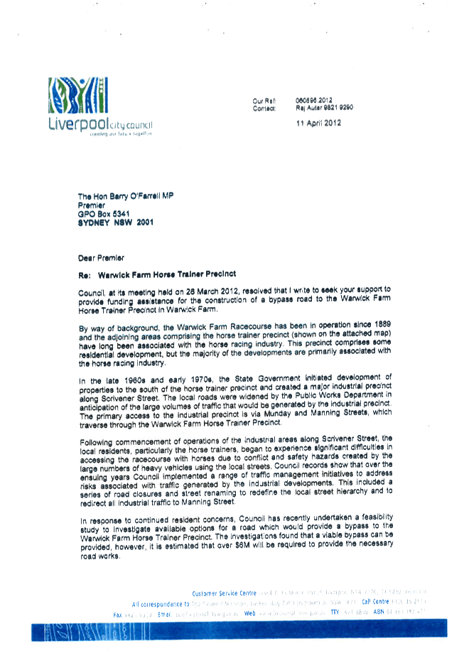
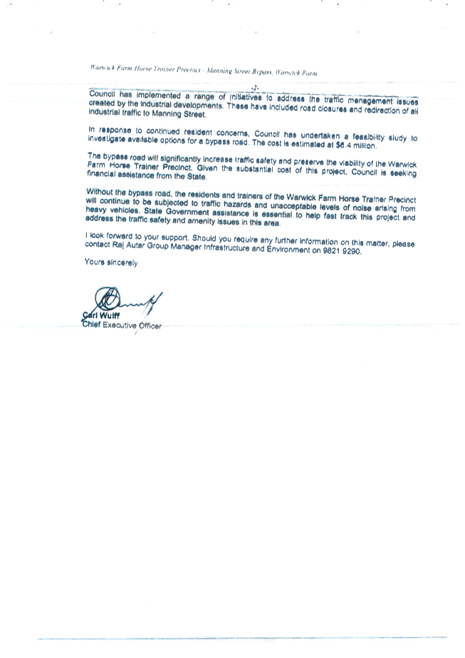
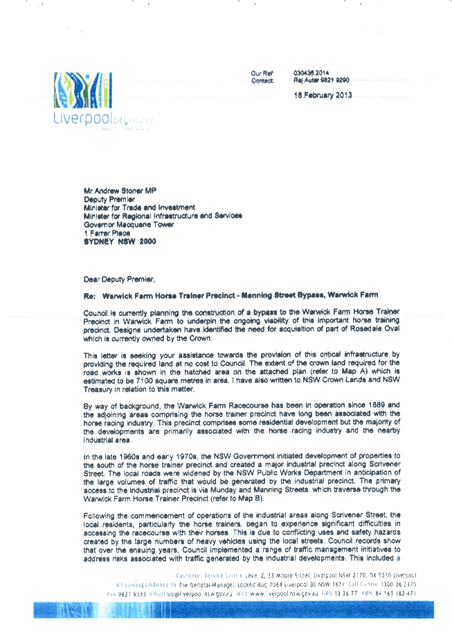
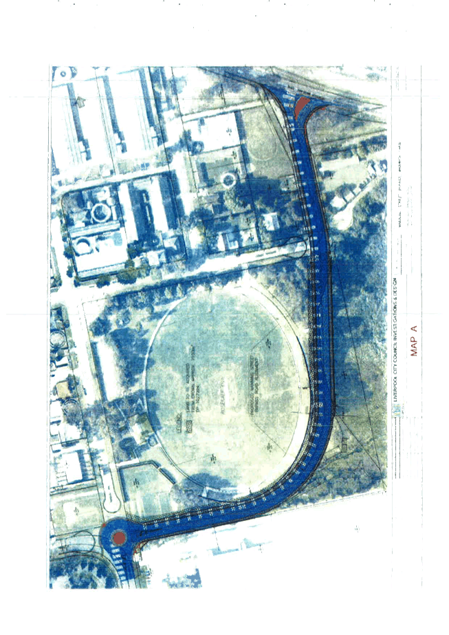
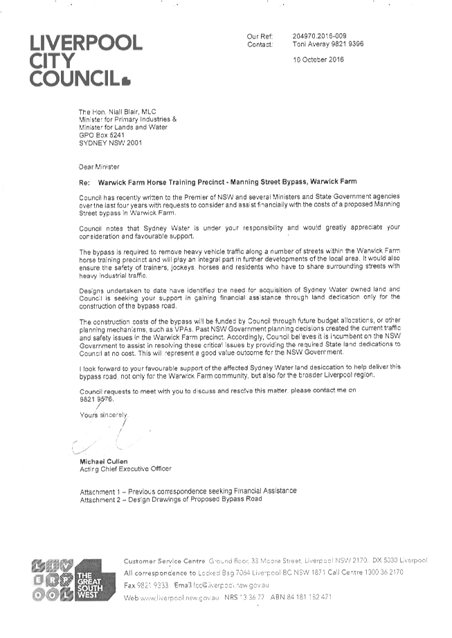
· Manning Street Bypass – Council has identified the need for a Manning Street bypass road, from GMD along Shore Street to Priddle Street, to address the existing conflicts between heavy vehicles and horse movements across Manning Street.
Council established the Warwick Farm Steering Committee to discuss land use conflicts within the Warwick Farm precinct and to progress considerations for a bypass road to resolve these conflicts. Committee discussions and recommendations are discussed further below. Committee members and residents have advocated for Council to design and construct the road over several years.
Council resolved in July 2016 to again progress the project. Concept and detailed designs of the bypass road are being finalised and funding will be sought in next financial year’s budget for the required land acquisition for the road.
· GMD and Munday Street Intersection – The current seagull intersection is unsafe and unsatisfactory and urgently requires upgrading. Under the ATC VPA previously discussed, Council the intersection is to be upgraded to a signalised intersection prior to an OC being issued for the industrial development on the Coopers Paddock site. As noted above, in April 2016, the JRPP approved a development proposal by Stockland for industrial development on the Coopers Paddock site fronting GMD near the William Long Bridge. The required civil and traffic signals works have been approved by Council and the RMS. The intersection upgrade is expected to be carried out during this calendar year.
The traffic signals will permit safe and efficient traffic movements to and from the planning proposal site, while also addressing current safety and traffic conflicts at the intersection. Due to the close proximity of the GMD/Munday Street and GMD/Shore Street intersections, the traffic signals at the GMD/Munday Street will be decommissioned, once the bypass road and associated traffic signals at the Shore Street intersection are completed. At that time, left in/left out only turns will be permitted at the GMD/Munday Street intersection and a load limit will be imposed to restrict heavy vehicles on Munday Street.
RMS and TfNSW comments
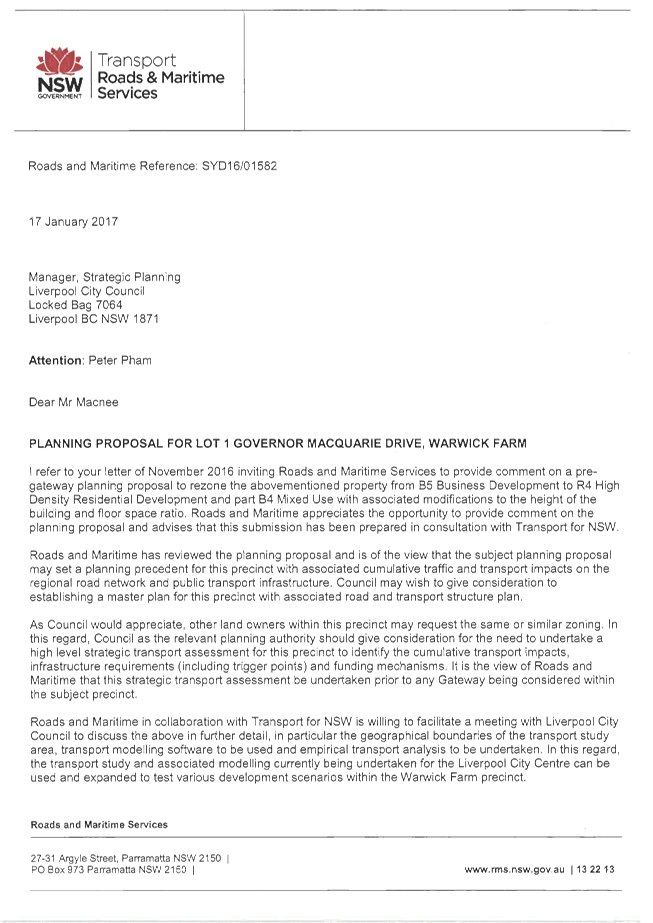
RMS and TfNSW have submitted joint comments. Their submission suggests that the planning proposal may set a planning precedent for the Warwick Farm Precinct, with associated cumulative traffic and transport impacts on the regional road network and public transport infrastructure. The concerns regarding public transport are surprising given that the site is adjacent to the Warwick Farm railway station.
These comments further support Council’s proposed precinct planning approach to the Warwick Farm area more broadly, which will require an associated transport improvement plan to accommodate the additional developments.
Council officers met with RMS representatives, to clarify their submission and requirements for the assessment of the planning proposal. The RMS representatives confirmed their preference for a Warwick Farm Precinct Plan which would take into consideration the subject planning proposal and employment land uses.
However, should Council support the recommendation for the proposal to proceed to Gateway, the cumulative transport impact assessment can be conditioned as a Gateway requirement. This would be consistent with the approach that has been taken with a number of other planning proposals in and around the Liverpool city centre. The developer would also be required to undertake specific works and make a monetary contribution towards local and regional road improvements to accommodate the traffic/transport impacts of the proposed development.
Traffic and Transport Assessment and conclusions
Council’s Traffic and Transport Department has reviewed the proposal and accompanying Traffic Impact Assessment Report and provided the following comments:
The Traffic Impact Assessment Report has assessed a development with 950 units and 3,800m2 of commercial use, instead of a development yield with 950 units and 5,000m2 of retail use, proposed in the planning proposal.
In addition, the traffic generation potential of the planning proposal has been estimated based on a trip generation rate of 0.19 and 0.15 vehicles per hour, per unit, during weekday morning and afternoon peak hours respectively. These rates are based on surveyed sites close to public transport hubs such as Parramatta, Chatswood and Strathfield.
Based on existing travel characteristics for Warwick Farm (from TfNSW Journey to Work data), a trip generation rate of 0.29 vehicles per hour, per unit, is considered the appropriate traffic generation rate.
Based on a trip generation rate of 0.29 vehicle per hour, per unit, and RMS specified traffic generation potential of 12.3 veh/hour, for the retail component, the planning proposal, could generate traffic volumes of approximately 760 veh/hour during the morning and afternoon peak periods.
These traffic volumes would result in a significant increase in traffic movements on the surrounding road network, i.e. Hume Highway, Governor Macquarie Drive and Munday Street. In addition, the development would be expected to generate significant pedestrian movements. The proposed residential and retail developments would also exacerbate vehicle, horse and pedestrian conflicts.
The following road improvements will be required in the Warwick Farm area to accommodate the planning proposal and existing and background traffic growth, along with traffic arising from other planned additional developments in the area:
· GMD - Road widening of the section between Hume Highway and Shore Street to a four lane road.
· Bypass road - Construction of the bypass road and signalised intersection at GMD and Shore Street.
· GMD and Munday Street intersection – Signalisation until completion of the bypass road and traffic signals at GMD and Shore Street, after which the signals will be decommissioned and the intersection modified to left in/left out only.
· Hume Highway and GMD intersection – Intersection upgrade to provide two right lanes from Hume Highway into GMD, a left slip lane from Hume Highway into GMD, and a dedicated left turn lane from GMD into Hume Highway.
In addition, the subject proposed development will be required to reconstruct the section of Warwick Street fronting the development site.
As noted above, at the December briefing to the Planning and Development Committee, the following three options were discussed:
1. Reject the planning proposal as submitted on planning grounds because the proposal lacks strategic or site specific merit; or
2. Defer consideration of the planning proposal until Council has adopted a broader precinct-wide strategy for Warwick Farm: or
3. Request a modified planning proposal with a reduced density based on an FSR of 2:1 which equates to approximately 500 residential apartments.
As discussed during the briefing session, the traffic assessment is that an FSR of 2:1 which equates to approximately 500 residential units can be supported on the site, subject to the completion of detailed traffic modelling following Gateway approval and the range of traffic improvements discussed in this report.
Proposed Voluntary Planning Agreement (VPA)
To support the subject planning proposal, the developer has submitted a public benefit offer to Council. The developer will enter into a VPA in association with the planning proposal, and will also make required Section 94 developer contributions in accordance with Council’s Section 94 contribution scheme as part of future DA approvals.
Through the VPA, the developer proposes to contribute an amount of $10,000 per residential dwelling unit towards the construction of the future bypass road. This commitment is consistent with Council’s adopted Planning Agreement Policy, which identifies a developer contribution under a VPA for planning proposals of $10,000 per unit for non-waterfront development, and $15,000 for waterfront development.
The developer will also contribute towards the following road improvements:
· Traffic congestion mitigation measures in Manning and Munday Streets; and
· Upgrading of existing cycle ways and pedestrian walkways between Warwick Farm and Liverpool CBD with regard to continuity and signage.
In addition, the following works will be required to be carried out by the developer to accommodate the traffic impacts of the proposed development:
· GMD - Road widening of the section fronting the development site to a four lane road.
· Hume Highway and GMD intersection – upgrade to provide a dedicated left turn lane from GMD into Hume Highway.
· GMD and Munday Street intersection – Upgrade to left in/out and decommissioning of signals, only when bypass road is completed.
These road works and contributions are to be agreed to in-principle for the planning proposal to proceed to Gateway.
The applicant has also proposed to include 5% key worker housing within the development.
Warwick Farm Steering Committee and residents’ petition
Council established the Warwick Farm Steering Committee to consider the following:
· Investigate potential impacts of imposing trading hour restrictions on racing community and industrial area
· Determine appropriate economical means of minimising impacts on majority of stakeholders
· Reducing land use conflicts
· Possible construction of bypass road
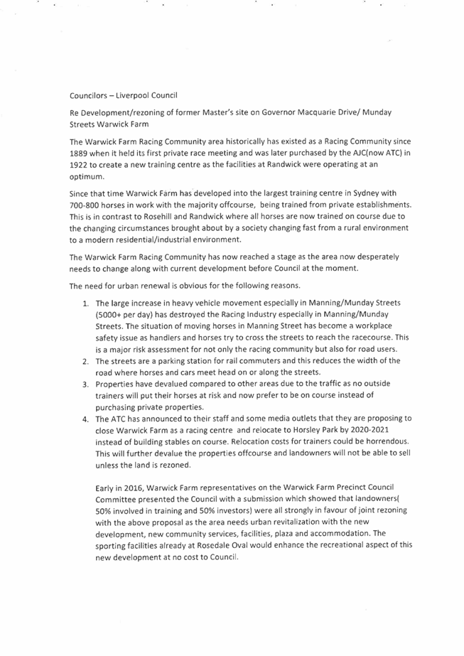
A petition by Warwick Farm residents seeking rezoning to R4 High Density Residential was submitted to Council in March 2016. The petition was signed by 39 Warwick Farm property owners. Council received further representations from a number of residents in December 2016 supporting the subject planning proposal and urging Council to progress the rezoning of the broader precinct. Copies of these documents are attached for the information of Councillors.
At the Committee Meeting of 5 July 2016, the Committee members were informed that Council is undertaking an LEP Review which includes the Warwick Farm Precinct as a whole. Concerns were raised by Committee members about the timing of construction of bypass road and the fact that they have not seen any progress on the road despite previous commitments by Council to commence the project.
At the following Council meeting of 27 July 2016, Council resolved as follows:
That Council receives and adopts the Minutes of the Warwick Farm Steering Committee Meeting held on 5 July 2016 noting the following resolutions made by the Committee:
(a) A/CEO to prepare within one week a timeline to complete detailed design and costing, land acquisition and necessary approvals to commence the bypass road construction (putting aside the funding issue).
(b) A/CEO to write to State Government to seek dedication of required State land at no cost to Council for construction of bypass road.
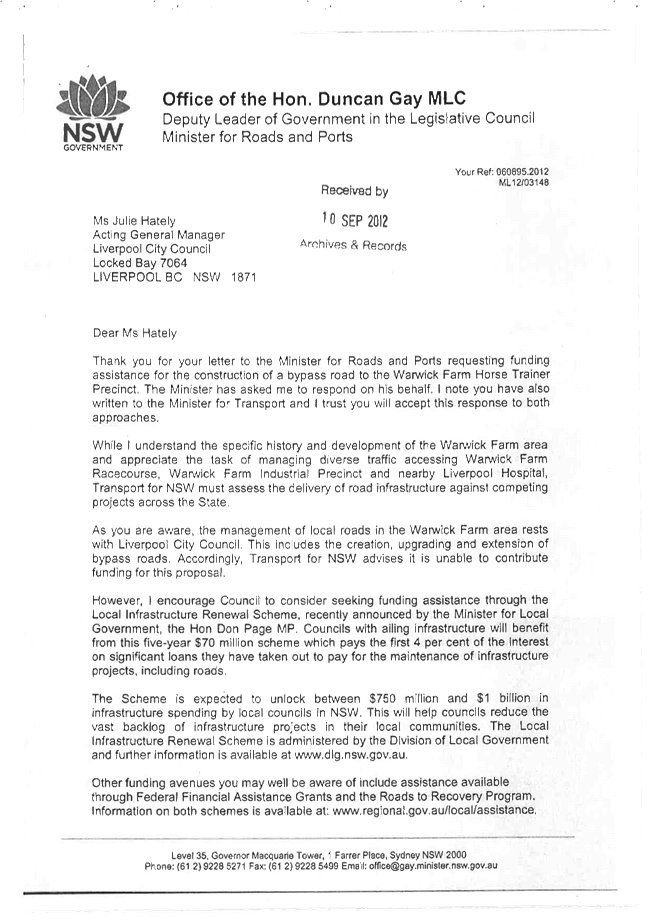
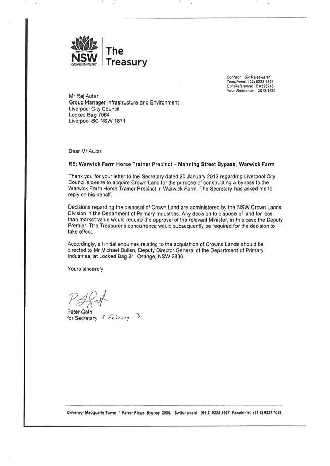
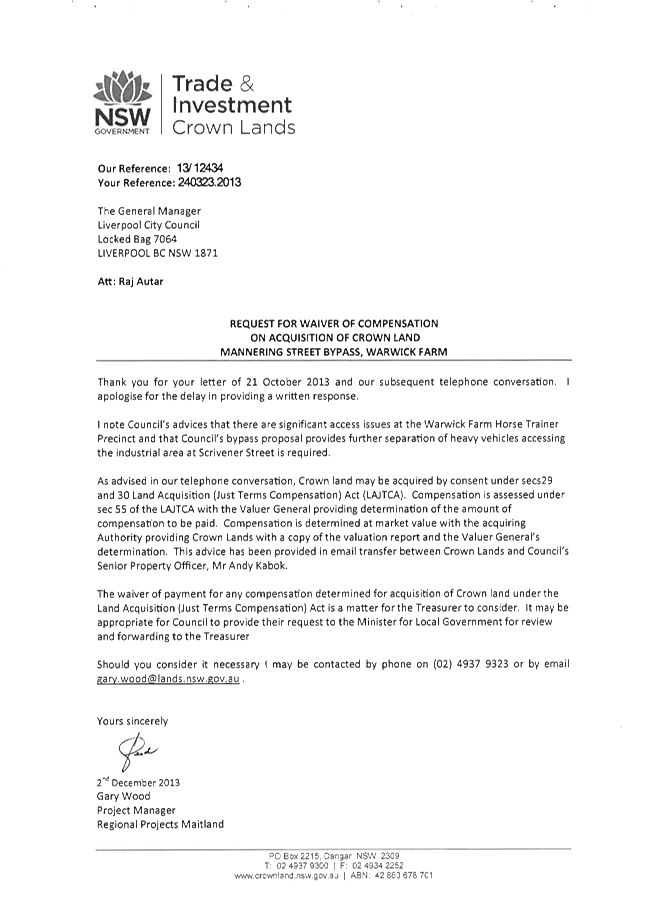
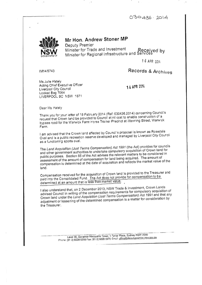
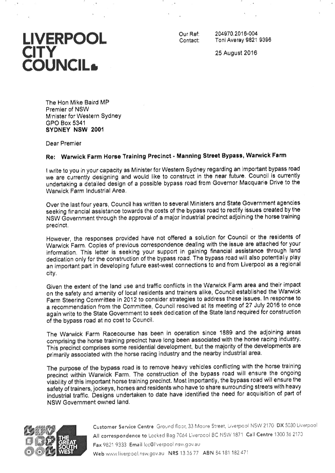
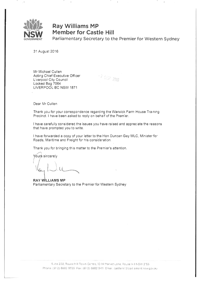
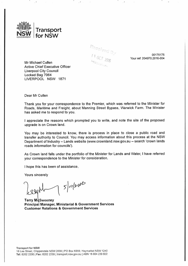
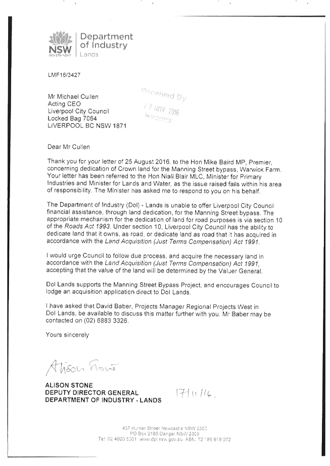
Council officers advised that subject to the land acquisition being finalised and funding being available, construction can be started in the second half of 2017/18 financial year. Funds will be sought in the capital program in the 2017/18 budget to progress land acquisitions. Multiple representations to the State government over several years seeking State government land dedication have been rejected. Following the July Council meeting, officers again wrote to the State government and received another response advising that the land would not be dedicated. Copies of relevant correspondence are attached for the information of Councillors.
Economic Impacts
The current B5 zoning on the site supports bulky goods development. However, as noted above, the owner has determined not to proceed with the proposed bulky goods hardware development on economic grounds. While the application is not supported by a detailed economic study, a number of new employment generating developments have recently been approved within the immediate vicinity, including the Stockland industrial development and the Inglis equestrian sales and hotel development, with the Inglis development under construction. Additionally, the planning proposal includes up to 5000m2 of retail floor space The proposed retail uses include a small supermarket to support the local Warwick Farm community. There are currently no retail facilities for this community with the nearest supermarket being located at Chipping Norton. The proposed future supermarket and café will represent both an economic and a social benefit for this community.
The planning proposal also proposes community facilities and publically accessible open space, and the applicant has noted that it will not compete with or impact on the primary role and function of the Liverpool Central City. Rather, the increase in residential population will provide economic support to the businesses and services in the commercial core of Liverpool. It is also noted that the site is ideally positioned as a Transit Oriented Development given it is adjacent to the Warwick Farm railway station.
The future Warwick Farm precinct planning process will include an economic study to consider the economic viability of the horse training. It is noted that while the ATC has verbally advised that it has no plan to repurpose the racecourse at this time, residents have written to Council with anecdotal reports of relocation plans by 2020-2021. The main issue for the Warwick Farm precinct is to resolve the current land use and traffic impacts. The industrial precinct to the south has been the subject of substantial major investment, particularly with companies such as Direct Freight and Visy. There is a pressing need for the bypass road to be constructed to resolve existing conflicts and to enable the future economic opportunities for the precinct to be considered in the proposed precinct planning process. The VPA proposed by the applicant presents an opportunity to progress the bypass road, delivering a significant community benefit and addressing long-standing traffic conflicts.
Social Impacts
The proponent has invested in a comprehensive Social Impact Assessment (SIA) (Refer to Appendix C in Attachment 1) to identify the requirements to support the proposed residential density. The proposal indicates that the increased density as a result of the redevelopment of the site will produce positive social outcomes such as increasing the diversity of housing to meet demographic and cultural change. The study also includes a range of recommendation to address any adverse impacts. The key recommendations include the following areas:
Transport and accessibility
· Traffic
· Walkway and cycleway connectivity
Amenity
· Development amenity
· Urban integration
Services and facilities
· Community and cultural services
· Recreation and open space
In summary, the SIA commissioned by the proponent, recommends a number of facilities and infrastructures upgrades. The study suggests that these can be addressed through a VPA or other contributions.
It is considered that the SIA recommendations will provide a basis for appropriate conditions in future development applications. The proposed reduced density of approximately 500 residential units will also have a reduced demand on and for social infrastructure. The site is ideally positioned in respect of public transport because of its proximity to the Warwick Farm railway station. The site is also in walking distance to a number of schools on the other side of the railway station. It is also within walking distance to open space at Rosedale Oval and a short drive to extensive open space and recreational areas at Chipping Norton Lakes.
The project will provide additional housing and diversity of housing choice. It is also noted that the applicant has agreed to include 5% key worker housing.
The proposed 5000m2 of retail floor space will include a small supermarket to support the local Warwick Farm community. There are currently no retail facilities for this community with the nearest supermarket being located at Chipping Norton. The proposed future supermarket and café will represent both an economic and a social benefit for this community.
The planning proposal will also provide additional recreation and amenity for residents and the broader community. Cycle and pedestrian paths have been designed around the site as well as a supervised children's play area designed to achieve maximum solar access. A public square is also incorporated to encourage the sense of place and belonging which will be an active space surrounded by cafes and restaurant facilities.
Flooding impact
The site is identified as being affected by flooding from the Georges River. The site is wholly affected by flooding under the 1% Annual Exceedance Probability (AEP) event. The planning proposal has not provided sufficient justification in the form of a flood impact assessment, an indication of potential impacts for the site or the local area as a result of the proposed development, or options for mitigation to address the potential flood risk.
The applicant will be required to comply with Ministerial Direction (Section 117 Directions 4.3 Flood Prone Land) prior to the proposal being gazetted. It is recommended that the proponent be required to undertake a comprehensive flood impact study and modelling analysis as a Gateway condition.
Housing Delivery priorities for Greater Sydney
The acceleration of housing supply is one of the top priorities for the NSW State Government.
In September 2015, the former Premier Mike Baird announced 12 Premier’s Priorities and 18 State Priorities which included the delivery of more housing for the growing population of NSW. NSW’s population is expected to grow by more than 100,000 every year. By 2036, an extra 2.1 million residents will need somewhere to live. Key considerations included:
· Increasing housing supply across NSW with the goal of delivering more than 50,000 approvals every year
· Sydney will need 664,000 new homes over the next 20 years.
· Increasing the supply of housing will put downward pressure on prices.
Premier Gladys Berejiklian has advised that her top priorities are as follows:
· local infrastructure;
· housing affordability; and
· building a strong economy, with an emphasis on more jobs.
The government is supporting future growth by establishing housing targets across NSW, and allocating funds to the Housing Acceleration Fund to build the infrastructure to support this growth. However, the housing cannot only be delivered in greenfield areas. Infill housing and urban renewal are also equally important.
The delivery of housing is also prioritised by the GSC in the draft amendment to A Plan for Growing Sydney released in November 2016 to accompany the draft District Plans. The draft also notes that there is a need to accelerate housing supply across Greater Sydney: While the planning system is not responsible for actually building new homes, we have a key role to play in creating opportunities for new housing in the right locations. The following key considerations are noted in the draft document:
· Projections for growth have been revised up since the release of A Plan for Growing Sydney.
· Need to accelerate housing supply across Greater Sydney with an additional 830,000 dwellings required by 2036.
· Create opportunities for new housing in the right locations.
· Urban renewal – focus new housing in existing centres with frequent public transport services within walking distance.
· Councils ideally placed to investigate opportunities for medium density infill in existing areas within 5km catchment of regional transport.
The draft South West District Plan emphasises these priorities and includes the requirement for each Council to develop a local housing strategy. Key considerations for the strategy will be opportunities to improve housing affordability and for additional capacity around strategic and district centres and other areas with good transport connectivity and service provision.
This proposed development with the reduced density recommended would deliver approximately 500 new homes in walking distance to the Warwick Farm railway station, which provides a major regional public transport link. The proposal will also deliver approximately 25 key worker dwellings, while the VPA will help fund a vital piece of major infrastructure in the bypass road.
Strategic Merit
The planning proposal process includes an analysis of State and Council planning strategies. A review of the proposal’s compatibility with relevant strategies is given below.
A Plan for Growing Sydney
A Plan for Growing Sydney is the relevant NSW Government metropolitan strategy for the Sydney area. It includes general goals and directions applicable across the Greater Sydney area and more localised subregional strategies
Goals and Directions
Goals and directions relevant to the planning proposal, along with a summary of the proponent and Council’s responses are described in Table 1.
Table 1: Goals and Directions Analysis
|
Item |
Assessment Response |
|
Goal 1: A competitive economy with world class services and transport |
|
|
Direction 1.7 Grow Strategic Centres – providing more jobs closer to home |
As noted above, Warwick Farm is not a Strategic Centre. This is also identified in Council’s adopted ‘Residential Development Strategy 2008’. The subject site is geographically isolated by the Warwick Farm Train Station, the Hume Highway, Warwick Farm Racecourse and the George’s River. |
|
Direction 1.11: Deliver Infrastructure |
The proponent has proposed a VPA to contribute to the construction of a significant piece of infrastructure, being the proposed Warwick Farm bypass road. The proponent will also pay S94 contributions as part of future development consents. |
|
Goal 2: A city of housing choice, with homes that meet our needs and lifestyles |
|
|
Direction 2.1: Accelerate housing supply across Sydney |
The proposed development will increase housing supply and choice within Liverpool within close proximity to a railway station. The development will also include 5% affordable housing. |
|
Direction 2.2: Accelerate urban renewal across Sydney – providing homes closer to jobs |
This direction seeks to support Council-led urban infill and local efforts to lift housing production close to Liverpool City Centre along transport corridors. The proposed development will be a catalyst for urban renewal in Warwick Farm. |
|
Direction 2.3: Improve housing choice to suit different needs and lifestyles. |
The direction seeks to promote housing strategies, subdivision of existing housing into medium density housing and the delivery of affordable housing. The planning proposal will lead to the provision of additional housing supply and choice within Liverpool. The densities on the northern edge of the Liverpool CBD, in existing R4 zoned area, have an FSR of 1.5:1 – 2:1 and building heights of 35m-45m. However the current proposed density in the proposal is not consistent with this and accordingly a reduced density of 2:1 FSR as outlined above is more appropriate and consistent with surrounding development. The applicant has also agreed to include 5% key worker housing in the development. |
|
Goal 3: A great place to live with communities that are strong, healthy and well connected |
|
|
Direction 3.1: Revitalise existing suburbs |
The proposal will help facilitate urban renewal in Warwick Farm. It is noted that the draft South West District Plan highlights that the broader Warwick Farm area is constrained by access, flooding and open space provisions. These issues will be key considerations in the future precinct planning process. The proposed VPA facilitates construction of the bypass road and the future development will be required to address the flooding impacts. It is noted that Rosedale Oval provides a recreational space in the precinct and bikeways will connect the precinct to Chipping Norton Lakes. |
|
Direction 3.3: Create healthy built environments |
The proximity of the site adjacent to the Warwick Farm railway station supports public transport use. The current upgrades to GMD associated with ATC development will also deliver a cycle way through to Chipping Norton and provide ready access to the Chipping Norton Lakes recreation area. The site is also in walking distance to Rosedale Oval and several schools on the other side of the railway station, accessed by the railway overpass and lifts. |
|
Goal 4: A sustainable and resilient city that protects the natural environment and has a balanced approach to the use of land and resources |
|
|
Direction 4.1: Protect our natural environment and biodiversity |
The site is affected by flooding under the 1% Annual Exceedance Probability (AEP) event and currently fails to accord with Ministerial Direction (Section 117 Directions 4.3 Flood Prone Land). It is recommended that the applicant be required to undertake a comprehensive flood impact study as part of Gateway approval. |
Draft South West District Plan
The Greater Sydney Commission published the Draft South West District Plan (District Plan) on 21 November 2016 for public exhibition. The draft District Plan sets out visions, priorities and actions for the development of the South West District of Greater Sydney. The Department’s Guide to Preparing Planning Proposals states that the draft District Plan is a consideration for determining the strategic merit of a planning proposal.
The proposed development will assist Council in meeting residential and employment targets for the South West District. In particular, it is noted that the development will include 5% key worker housing. Affordable housing is noted as an important requirement in the draft District Plan.
The draft South West District Plan also notes the following issues:
· The level of developer interest in Warwick Farm and the broader constraints in the Warwick Farm area, including access, flooding and open space provisions.
· The need to retain employment land in the area.
It is noted that the current B5 zoning on the subject site did not result in any development on the site. The planning proposal includes 5000m2 of retail uses. This will deliver economic and social benefits to the local community and will create new local jobs. The proposed VPA associated with the development will contribute to the construction of the bypass road, which will significantly improve long standing traffic issues and conflicts within the precinct.
The broader constraints will be addressed in the Warwick Farm precinct planning process. The precinct plan will be able to build on the benefits created by the construction of the bypass road.
Action P13 of the Draft South West District Plan designates the wider Liverpool City Centre as a Collaboration Area in order to maximise investment, productive and jobs outcomes. This is suggested to be undertaken through coordinated activities across State and local government to provide clarity to the private sector. While the boundary of the Collaboration Area is yet to be determined, it is likely the subject site will be included in this boundary. Given the small scale of the proposed development with the reduced density recommended in this report and the broader benefits it will bring to the Warwick Farm community including economic, social and traffic related, it is considered that the proposal can be supported to Gateway.
Conclusion
The planning proposal for Lot 1 Governor Macquarie Drive, Warwick Farm seeks to amend the LLEP 2008 to rezone the site from B5 Business Development to part R4 High Density Residential and part B4 Mixed Use, with increases to the FSR from 0.75:1 to 3.5:1 and HOB from 15m to part 45m and part 100m. The proposal would facilitate development on a scale of approximately 950 residential units in apartment block form ranging up to 30 storeys and include up to 5000sqm of retail floor area.
This report concludes that a reduced residential density can be supported to proceed to Gateway. It is recommended Council support a maximum FSR of 2:1 which equates to approximately 500 residential dwelling units, with a commensurate maximum building height of 45m.
Council’s Planning and Development Committee discussed the planning proposal at its meeting on 7 December 2016 and considered three options:
1. Reject the planning proposal as submitted on planning grounds because the proposal lacks strategic or site specific merit; or
2. Defer consideration of the planning proposal until Council has adopted a broader precinct-wide strategy for Warwick Farm: or
3. Request a modified planning proposal with a reduced FSR of 2:1 which equates to approximately 500 residential apartments.
Option 3 is supported as discussed in this report.
Council’s traffic assessment is that a level of development similar to the density west of the Warwick Farm Station can be supported at this time, noting that the applicant proposes a VPA to make a significant contribution to the construction of a bypass road. The bypass road will help resolve long standing traffic and land use conflicts which exist in this area. The bypass road has been the subject of representations from residents over a number of years.
A reduced density with an FSR of 2:1 which equates to approximately 500 residential apartments would be consistent with the level of the development close to the development site and would also reduce the social impacts of the proposed development. Detailed traffic and flood modelling are recommended to be conditioned as part of a Gateway approval.
The VPA proposed by the applicant will significantly contribute to the cost of construction of the bypass road. The applicant has also advised that the development will include 5% key worker housing.
Council officers propose to undertake a dedicated master planning exercise for the area as part of the current LEP review but planning is in the early stages. The future precinct plan will ensure that the current land use conflicts are resolved and will address amenity outcomes for residents and businesses in the locality. It is considered that a modified planning proposal of 500 units can be supported and progress concurrently with the broader precinct planning work.
A report on the proposed Strategic Framework for the broader LEP review, including discussion on the proposed precinct plans, will be presented to the March Council meeting.
CONSIDERATIONS
|
Economic and Financial |
Deliver and maintain a range of transport related infrastructure such as footpaths, bus shelters and bikeways. Deliver a high quality local road system including provision and maintenance of infrastructure and management of traffic issues. Facilitate economic development.
|
|
Environmental and Sustainability |
Promote an integrated and user friendly public transport service. Support the delivery of a range of transport options. |
Social and Cultural |
Regulate for a mix of housing types that responds to different population groups such as young families and older people. Deliver high quality services for children and their families. |
Civic Leadership and Governance |
Foster neighbourhood pride and a sense of responsibility. Operate a well developed governance system that demonstrates accountability, transparency and ethical conduct. |
ATTACHMENTS
1. Attachment 1 - Planning Proposal - Lot 1 Governor Macquarie Drive Warwick Farm - can be viewed online on Council webpage http://www.liverpool.nsw.gov.au/council/council-meetings#agendasView
2. Attachment 2 - RMS and TfNSW Joint SubmissionView
3. Petition by Warwick Farm Residents March 2016View
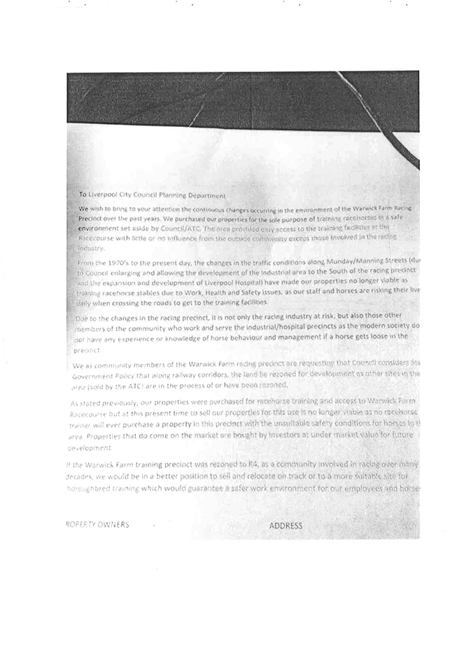
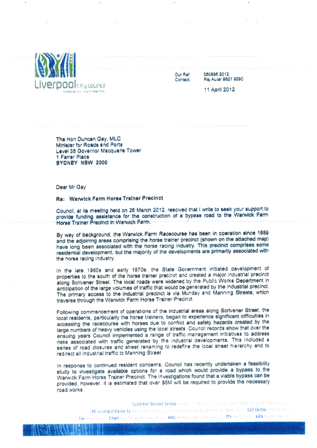
4. Letter from Warwick Farm Resident December 2016View
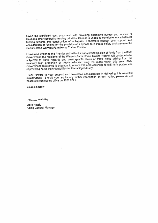
5. Correspondence regarding Land Dedication with State and Federal AgenciesView
6. VPA Offer March 2016View
7. Revised VPA Offer October 2016View
8. Latest VPA Offer February 2017View
|
213 |
|
|
DPG 03 |
Planning Proposal for Lot 1 Governor Macquarie Drive, Warwick Farm rezoning from B5 Business Zone to R4 High Density Residential Zone |
|
Attachment 1 |
Attachment 1 - Planning Proposal - Lot 1 Governor Macquarie Drive Warwick Farm - can be viewed online on Council webpage http://www.liverpool.nsw.gov.au/council/council-meetings#agendas |
Placeholder for Attachment 1
Planning Proposal for Lot 1 Governor Macquarie Drive, Warwick Farm rezoning from B5 Business Zone to R4 High Density Residential Zone
Attachment 1 - Planning Proposal - Lot 1 Governor Macquarie Drive Warwick Farm - can be viewed online on Council webpage
http://www.liverpool.nsw.gov.au/council/council-meetings#agendas
|
DPG 03 |
Planning Proposal for Lot 1 Governor Macquarie Drive, Warwick Farm rezoning from B5 Business Zone to R4 High Density Residential Zone |
|
Attachment 2 |
Attachment 2 - RMS and TfNSW Joint Submission |

|
DPG 03 |
Planning Proposal for Lot 1 Governor Macquarie Drive, Warwick Farm rezoning from B5 Business Zone to R4 High Density Residential Zone |
|
Attachment 3 |
Petition by Warwick Farm Residents March 2016 |


|
DPG 03 |
Planning Proposal for Lot 1 Governor Macquarie Drive, Warwick Farm rezoning from B5 Business Zone to R4 High Density Residential Zone |
|
Attachment 4 |
Letter from Warwick Farm Resident December 2016 |

|
DPG 03 |
Planning Proposal for Lot 1 Governor Macquarie Drive, Warwick Farm rezoning from B5 Business Zone to R4 High Density Residential Zone |
|
Attachment 5 |
Correspondence regarding Land Dedication with State and Federal Agencies |


|
DPG 03 |
Planning Proposal for Lot 1 Governor Macquarie Drive, Warwick Farm rezoning from B5 Business Zone to R4 High Density Residential Zone |
|
Attachment 6 |
VPA Offer March 2016 |
|
DPG 03 |
Planning Proposal for Lot 1 Governor Macquarie Drive, Warwick Farm rezoning from B5 Business Zone to R4 High Density Residential Zone |
|
Attachment 7 |
Revised VPA Offer October 2016 |

|
DPG 03 |
Planning Proposal for Lot 1 Governor Macquarie Drive, Warwick Farm rezoning from B5 Business Zone to R4 High Density Residential Zone |
|
Attachment 8 |
Latest VPA Offer February 2017 |
281
Ordinary Meeting 22 February 2017
Chief Executive Officer Report
|
CEO 01 |
Draft Community Strategic Plan |
|
Strategic Direction |
Leading Proactive Council Position Council as an industry leader, delivering best practice and innovation |
|
Key Policy |
Local Government Act 1993 |
|
File Ref |
036262.2017 |
|
Report By |
Emily Tinson - Acting Manager Corporate Strategy and Performance |
|
Approved By |
Kiersten Fishburn - Chief Executive Officer |
Executive Summary
Under the Local Government Act 1993, each local government area must have a Community Strategic Plan which is developed and endorsed by Council.
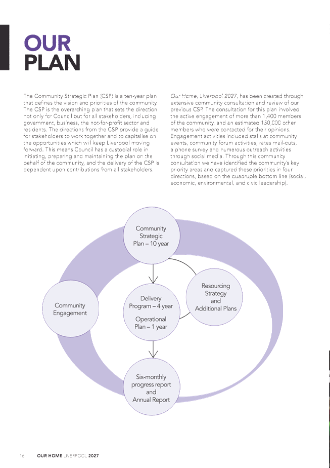
Through consultation with the community, a draft Community Strategic Plan – Our Home, Liverpool 2027 – has been developed to capture the community’s priorities and Council’s strategies for achieving those priorities.
It is recommended that Council approve the draft Community Strategic Plan to go on public exhibition for 28 days, subject to Council recommendations.
|
That Council approves the draft Community Strategic Plan to go on public exhibition for 28 days, subject to Council recommendations.
|
REPORT
Under the Local Government Act 1993, each local government area must have a Community Strategic Plan which is developed and endorsed by Council. The plan must cover a minimum timeframe of 10 years.
The Community Strategic Plan identifies the community’s main priorities and aspirations for the future and Council’s strategies for achieving those priorities.
The plan must address social, economic, environmental and leadership issues in an integrated manner. It must also be based on the social justice principles of equity, access, participation and rights.
The draft Community Strategic Plan – Our Home, Liverpool 2027 – has been developed through consultation with the community over the past six months. To date, more than 1500 community members have had their say on the future of Liverpool through an online survey, social media, at events, Council committees, and rural and urban forums.
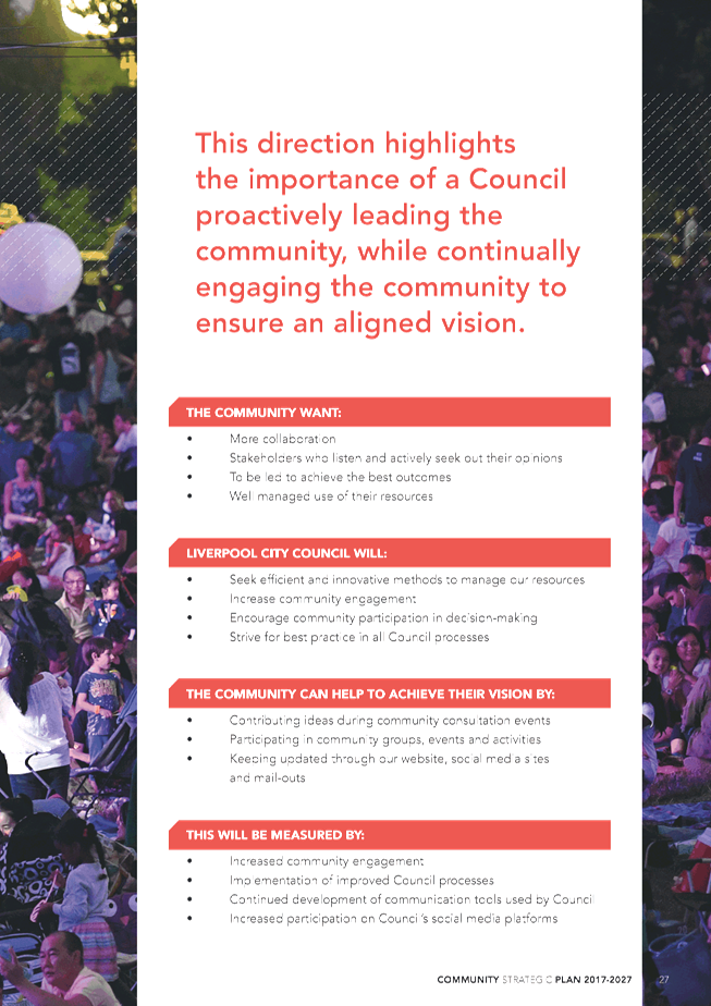
The draft plan delivers a shared vision for Liverpool based upon the aspirations of the community. It identifies the community’s priorities and categorises them in a balanced way using the quadruple bottom line (social, economic, environmental and leadership) as the basis for the directions. The plan also identifies strategies for Council to achieve the community’s priorities.
Actions and activities which Council will undertake to achieve the community’s priorities will be detailed in the new Delivery Program (four years) and Operational Plan (one year), which will be brought to Council in April.
Consultation on the draft Community Strategic Plan will continue during the exhibition period with the draft promoted through Liverpool Listens and social media. Two community focus groups will also provide feedback on the plan.
Council will consider submissions and review the document before bringing the Community Strategic Plan to Council for adoption.
It is recommended that Council approve the draft Community Strategic Plan to go on public exhibition for 28 days, subject to Council recommendations.
CONSIDERATIONS
|
Economic and Financial |
Further develop a commercial centre that accommodates a variety of employment opportunities. Deliver and maintain a range of transport related infrastructure such as footpaths, bus shelters and bikeways. Encourage and promote businesses to develop in the hospital, health and medical precinct (of the City Centre). Provide efficient parking for the City Centre. Enhance the environmental performance of buildings and homes. Deliver a high quality local road system including provision and maintenance of infrastructure and management of traffic issues. Facilitate economic development. Facilitate the development of new tourism based on local attractions, culture and creative industries. Further develop a commercial centre that accommodates a variety of employment opportunities (in the City Centre). |
|
Environmental and Sustainability |
Minimise household and commercial waste. Manage the environmental health of waterways. Manage air, water, noise and chemical pollution. Protect, enhance and maintain areas of endangered ecological communities and high quality bushland as part of an attractive mix of land uses. Raise community awareness and support action in relation to environmental issues. Promote an integrated and user friendly public transport service. Support the delivery of a range of transport options. |
Social and Cultural |
Raise awareness in the community about the available services and facilities. Provide cultural centres and activities for the enjoyment of the arts. Support policies and plans that prevent crime. Preserve and maintain heritage, both landscape and cultural as urban development takes place. Regulate for a mix of housing types that responds to different population groups such as young families and older people. Support community organisations, groups and volunteers to deliver coordinated services to the community. Promote community harmony and address discrimination. Support access and services for people with a disability. Deliver high quality services for children and their families. |
Civic Leadership and Governance |
Act as an environmental leader in the community. Undertake communication practices with the community and stakeholders across a range of media. Foster neighbourhood pride and a sense of responsibility. Facilitate the development of community leaders. Encourage the community to engage in Council initiatives and actions. Provide information about Council’s services, roles and decision making processes. Deliver services that are customer focused. Operate a well-developed governance system that demonstrates accountability, transparency and ethical conduct. Actively advocate for federal and state government support, funding and services. |
ATTACHMENTS
1. Draft Community Strategic Plan 14 Feb 2017View
Ordinary Meeting 22 February 2017
Chief Executive Officer Report
|
CEO 02 |
Strategic Panel Minutes 13 February 2017 |
|
Strategic Direction |
Leading Proactive Council Lead partnerships and collaboration with community, business and governments |
|
Key Policy |
Long-Term Financial Plan |
|
File Ref |
036497.2017 |
|
Report By |
Emily Tinson - Acting Manager Corporate Strategy and Performance |
|
Approved By |
Kiersten Fishburn - Chief Executive Officer |
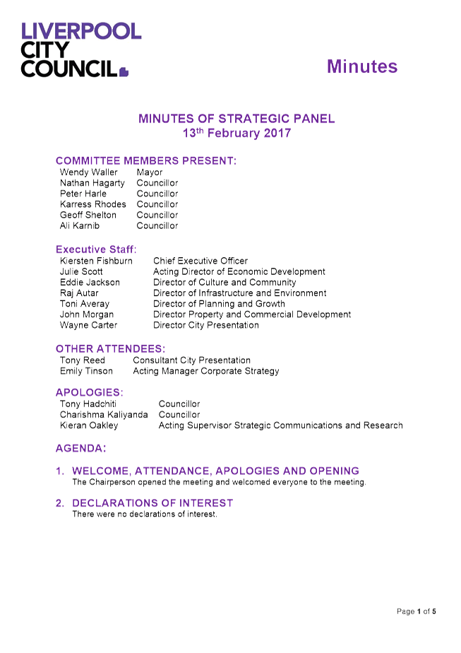
Executive Summary
This report tables the minutes of the Strategic Panel held on 13 February 2017.
|
That Council receives the minutes of the Strategic Panel held on 13 February 2017.
|
REPORT
The Strategic Panel met on 13 February 2017 and considered five agenda items. The minutes are attached for the information of Council.
CONSIDERATIONS
|
Economic and Financial |
There are no economic and financial considerations. |
|
Environmental and Sustainability |
There are no environmental and sustainability considerations. |
Social and Cultural |
There are no social and cultural considerations. |
Civic Leadership and Governance |
The Strategic Panel will allow a coordinated and integrated approach to addressing key community issues. |
ATTACHMENTS
1. Strategic Panel Minutes - 13 February 2017View
|
319 |
|
|
CEO 02 |
Strategic Panel Minutes 13 February 2017 |
|
Attachment 1 |
Strategic Panel Minutes - 13 February 2017 |

319
Ordinary Meeting 22 February 2017
Chief Financial Officer
|
CFO 03 |
Minutes of Budget Review Panel 9 February 2017 |
|
Strategic Direction |
Leading Proactive Council Provide business excellence and financial sustainability to deliver services that meet community expectations |
|
Key Policy |
Long-Term Financial Plan |
|
File Ref |
037198.2017 |
|
Report By |
George Georgakis - Manager Council and Executive Services |
|
Approved By |
Gary Grantham - Chief Financial Officer / Director Corporate Services |
Executive Summary
This report tables the Minutes of the Budget Review Panel meeting held on 9 February 2017.
|
That Council adopts the Minutes of the Budget Review Panel meeting held on 9 February 2017. |
REPORT
The Minutes of the Budget Review Panel held on 9 February 2017 are attached for the information of Council.
Part of the Minutes contained discussion and information that would, if disclosed, confer a commercial advantage on a person with whom the Council is conducting (or proposes to conduct) business. As such, in accordance with s10(A)(2)(c) of the Local Government Act, a separate item with the complete minutes from the meeting has been included in the Confidential Section on this Council Agenda.
CONSIDERATIONS
|
Economic and Financial |
Further develop a commercial centre that accommodates a variety of employment opportunities. Deliver and maintain a range of transport related infrastructure such as footpaths, bus shelters and bikeways. Deliver a high quality local road system including provision and maintenance of infrastructure and management of traffic issues. Facilitate economic development. |
|
Environmental and Sustainability |
Raise community awareness and support action in relation to environmental issues. |
Social and Cultural |
Raise awareness in the community about the available services and facilities. |
Civic Leadership and Governance |
Undertake communication practices with the community and stakeholders across a range of media. Encourage the community to engage in Council initiatives and actions. Provide information about Council’s services, roles and decision making processes. Deliver services that are customer focused. Operate a well developed governance system that demonstrates accountability, transparency and ethical conduct. Actively advocate for federal and state government support, funding and services. |
ATTACHMENTS