COUNCIL AGENDA
Ordinary Council Meeting
26 August 2020
170 GEORGE STREET LIVERPOOL
You are hereby notified
that an Ordinary Council Meeting of Liverpool City Council will be held
on Wednesday, 26 August 2020 commencing at 6.00pm.
Liverpool City Council
Meetings are livestreamed onto Council’s website and remain on
Council’s website for a period of 12 months. If you have any enquiries, please contact Council
and Executive Services on 8711 7584.


Dr Eddie Jackson
ACTING CHIEF EXECUTIVE
OFFICER
Opening
Acknowledgment of Country and Prayer
Apologies
Condolences
MAYOR 01 Condolence
- Victims of the Beirut Explosion.................................................. 5......... 1
Confirmation of Minutes
Ordinary
Council Meeting held on 29 July 2020...................................................................... 6
Declarations of Interest
Public Forum
Mayoral Report
MAYOR 02 Local
Government Representation on the National Cabinet......................... 55......... 2
Chief Executive Officer Report
CEO 01 Local
Government NSW Conference 2020.................................................... 57......... 3
CEO 02 Biannual
Progress Report.............................................................................. 74......... 4
CEO 03 Nomination
for Open Space Legacy Program (to be provided in Addendum Booklet)
City Economy and Growth Report
EGROW 01 Draft
Warwick Farm Racing Precinct Structure Plan, Planning Proposal and Local
Contributions Plan.......................................................................................... 76......... 5
EGROW 02 Report
back - Consideration of implementing a Development Assessment Compliance Policy.......................................................................................... 98......... 6
EGROW 03 Post
Exhibition Report - Liverpool Local Environmental Plan 2008 Amendment 71 -
Rezoning of certain lands in Prestons for Environmental Conservation..... 102......... 7
EGROW 04 Status
update on planning proposal requests in Moorebank....................... 111......... 8
EGROW 05 Street
Naming Request - Austral.................................................................. 136......... 9
EGROW 06 LEP
Review: Public Exhibition outcomes - Phase 1 Planning Proposal and draft
planning strategies (to be provided in Addendum Booklet)
City Community and Culture
Report
COM 01 Report
back to Council - Alcohol-Free Zones Public Exhibition.................. 140....... 10
COM 02 Report
Back to Council - Mimosa Park, 22 Box Rd, Casula........................ 144....... 11
COM 03 COVID-19
Impact on Sporting Field Hire Revenue..................................... 154....... 12
COM 04 Collingwood
Visitation Precinct Masterplan................................................. 161....... 13
City Corporate Report
CORP 01 Investment
Report July 2020....................................................................... 173....... 14
City Presentation Report
NIL
City Infrastructure and
Environment Report
NIL
Committee Reports
CTTE 01 Minutes
of the Environment Advisory Committee held on 22 June 2020.... 182....... 15
CTTE 02 Minutes
of the Liverpool Pedestrian, Active Transport and Traffic Committee meeting
held on 22 July 2020....................................................................... 191....... 16
Questions with Notice
QWN 01 Question
with Notice - Clr Hagarty - Appeal Powers Against Land and Environment Court
Decisions............................................................................................. 216....... 17
QWN 02 Question
with Notice - Clr Kaliyanda - Processing of Organic Waste in the Liverpool LGA............................................................................................... 218....... 18
QWN 03 Question
with Notice - Clr Hagarty - Western Sydney Parklands Trust...... 221....... 19
QWN 04 Question
with Notice - Clr Rhodes - Georges River Bank Stabilisation...... 223....... 20
QWN 05 Question
with Notice - Clr Kaliyanda - Wattle Grove Lake.......................... 225....... 21
Presentations by Councillors
Notices of Motion
NOM 01 Parking
on Verges and Nature Strips........................................................... 226....... 22
NOM 02 Register
of Legal Proceedings..................................................................... 229....... 23
NOM 03 Use
of Data to Improve Energy Efficiency and Reduce Pollution................ 230....... 24
Council in Closed Session
The
following items are listed for consideration by Council in Closed Session with
the public excluded, in accordance with the provisions of the Local Government
Act 1993 as listed below:
CONF 01 Endorsement of the Liverpool
Access Committee membership 2020 - 2022
Reason: Item CONF 01 is confidential
pursuant to the provisions of s10(A)(2)(a) of the Local Government Act because
it contains personal matters concerning particular individuals (other than
councillors).
CONF 02 ST2954 - Waste, recyclables and
Garden Organics Collection Services (2020/2321)
Reason: Item CONF 02 is
confidential pursuant to the provisions of s10(A)(2)(d i) of the Local
Government Act because it contains commercial information of a confidential
nature that would, if disclosed prejudice the commercial position of the person
who supplied it.
CONF 03 Funding for RAID Moorebank Class
1 Merits Appeal
Reason: Item CONF 03 is
confidential pursuant to the provisions of s10(A)(2)(g) of the Local Government
Act because it contains advice concerning litigation, or advice that would
otherwise be privileged from production in legal proceedings on the ground of
legal professional privilege.
Close
0
Ordinary Meeting
26 August 2020
|
MAYOR 01
|
Condolence - Victims of the Beirut
Explosion
|
|
Strategic
Direction
|
Creating
Connection
Celebrate
diversity, promote inclusion and recognise heritage
|
|
File Ref
|
218625.2020
|
CONDOLENCE (to be read by Mayor Waller)
On 4 August 2020, a massive explosion tore
through the port area in Beirut, in Lebanon, killing at least 163 people,
including one Australian, and injuring more than 5000. The death toll is
expected to rise as emergency workers continue to search through devastated
areas of the city. About 300,000 people have been left homeless.
The force of the explosion destroyed the
port and resulted in the near total destruction of downtown Beirut within at
least a 5km radius. The explosion was felt in parts of Europe and heard in
Cyprus, an estimated 240km away.
Liverpool is home to a large number of
people of Lebanese ancestry, and Council values the contribution Lebanese
Australians have made to the rich fabric of Liverpool. Many people in the
Liverpool Local Government Area remain deeply distressed about the explosion
and its impact on Beirut. Others continue to have concerns for the safety and
welfare of their family members and friends who remain in Lebanon.
On behalf of Liverpool City Council, I
express my deepest condolences to the families and friends of the victims, and
my thoughts and prayers are with the people who were injured in the explosion.
To the people of Lebanon and all Lebanese Australians, I offer my solidarity
and support on behalf of all Councillors during this devastating time.
|
That Council write to the Lebanese Consulate expressing
our condolences and solidarity.
|
Nil.
MINUTES OF THE Ordinary
Meeting
HELD ON 29 July 2020
PRESENT:
Mayor Wendy Waller
Councillor Ayyad
Councillor Balloot (arrived at the meeting at 6.18pm)
Councillor Hadchiti
Councillor Hadid
Councillor Hagarty
Councillor Harle
Councillor Kaliyanda
Councillor Karnib (arrived at the meeting at 6.18pm)
Councillor Rhodes
Councillor Shelton
Dr Eddie Jackson, Acting Chief Executive Officer
Mr Tim Moore, Director City Economy and Growth / Deputy Chief Executive
Officer
Mr George Hampouris, Acting Director City Corporate
Ms Tina Sangiuliano, Acting Director City Community and Culture
Mr Peter Patterson, Director City Presentation
Mr Raj Autar, Director City Infrastructure and Environment
Mr Andrew Stevenson, Chief
Strategy and Engagement Officer
Mr David
Smith, Manager Planning & Transport Strategy
Mr James Ng,
Acting General Counsel Manager Governance Legal and Procurement
Mr Vishwa
Nadan, Chief Financial Officer
Mr John
Milicic, Manager Property
Mr George
Georgakis, Manager Council and Executive Services
The meeting commenced at
6.00pm.
|
STATEMENT REGARDING
WEBCASTING OF MEETING
|
The Mayor reminded everyone that in accordance with Council’s
Code of Meeting Practice (other than the Public Forum Section), the
meeting is being livestreamed.
|
|
ACKNOWLEDGMENT OF
COUNTRY, PRAYER OF COUNCIL AND AFFIRMATION TO BE READ BY
|
The prayer of the Council was read by Dr Eddie Jackson, Acting Chief
Executive Officer.
|
APOLOGIES
Nil
CONDOLENCES
Nil
Confirmation of Minutes
Motion: Moved:
Clr Shelton Seconded:
Clr Kaliyanda
|
That the
minutes of the Ordinary Meeting held on 24 June 2020 be confirmed as a true
record of that meeting.
|
On being put to the meeting the motion was declared CARRIED.
Declarations of Interest
Mayor
Waller declared a non-pecuniary, less than significant interest in the
following item:
Item EGROW 06: Business Resilience Grants
Reason: Mayor
Waller knows and has associations with many local business owners.
Mayor
Waller remained in the virtual room for the duration of the item.
Clr
Shelton declared a non-pecuniary, less than significant interest in the
following item:
Item EGROW 06: Business Resilience Grants
Reason: Clr
Shelton knows and has associations with many local business owners.
Clr
Shelton remained in the virtual room for the duration of the item.
Clr
Hadchiti declared a pecuniary interest in the following item:
Item INF 01: Wianamatta South Creek Flood Study Update
Reason: Clr
Hadchiti has investment in property referred to in the report.
Clr Hadchiti left the virtual room for
the duration of the item.
Clr
Hadchiti declared a non-pecuniary, less than significant interest in the
following item:
Item EGROW 06: Business Resilience Grants
Reason: Clr
Hadchiti knows and has associations with many local business owners.
Clr
Hadchiti remained in the virtual room for the duration of the item.
Clr
Ayyad declared a non-pecuniary, less than significant interest in the following
item:
Item CONF 07: Liverpool Civic Place Independent Review
Reason: Clr
Ayyad has a close relative who is in a senior role at Clayton Utz.
Clr Ayyad remained in the virtual room
for the duration of the item.
Clr
Ayyad declared a non-pecuniary, less than significant interest in the following
item:
Item EGROW 06: Business Resilience Grants
Reason: Clr
Ayyad knows and has associations with many local business owners.
Clr
Ayyad remained in the virtual room for the duration of the item.
Clr
Rhodes declared a non-pecuniary, less than significant interest in the following
item:
Item EGROW 06: Business Resilience Grants
Reason: Clr
Rhodes knows and has associations with many local business owners.
Clr
Rhodes remained in the virtual room for the duration of the item.
Clr
Hagarty declared a non-pecuniary, less than significant interest in the
following item:
Item EGROW 06: Business Resilience Grants
Reason: Clr
Hagarty knows and has associations with many local business owners.
Clr
Hagarty remained in the virtual room for the duration of the item.
Clr
Kaliyanda declared a non-pecuniary, less than significant interest in the
following item:
Item EGROW 06: Business Resilience Grants
Reason: Clr
Kaliyanda knows and has associations with many local business owners.
Clr
Kaliyanda remained in the virtual room for the duration of the item.
Clr
Hadid declared a non-pecuniary, less than significant interest in the following
item:
Item EGROW 06: Business Resilience Grants
Reason: Clr
Hadid knows and has associations with many local business owners.
Clr
Hadid remained in the virtual room for the duration of the item.
Public Forum
Presentation
– items not on agenda
1. Mrs
Vicki Andrews made a written submission to Council on the following matter:
Promotion of
Liverpool Regional Museum
Representation
– items on agenda
Nil
Chief Executive Officer Report
ITEM NO: CEO 01
FILE NO: 176066.2020
SUBJECT: Annual
Report to Council by the Internal Ombudsman
|
COUNCIL
DECISION
Motion: Moved:
Clr Shelton Seconded:
Clr Hadid
That Council:
1.
Receive and note the
annual report presented by the Internal Ombudsman.
2.
Thank the Internal Ombudsman, Mr David Maguire for his hard work
during his time at Council.
On being put to the meeting the
motion was declared CARRIED.
|
Clr Balloot and Clr
Karnib joined the meeting at 6.18pm.
ITEM NO: CEO 02
FILE NO: 179105.2020
SUBJECT: Review of
Media Policy
|
COUNCIL
DECISION
Motion: Moved:
Clr Hagarty Seconded:
Clr Kaliyanda
That Council adopt the Media
Policy for a two-year period.
On being put to the meeting the
motion was declared CARRIED and the Foreshadowed motion (which Clr Rhodes was
proposing to move) lapsed.
Vote for: Mayor
Waller, Clr Ayyad, Clr Balloot, Clr Hadchiti, Clr Hadid, Clr Hagarty, Clr
Kaliyanda, Deputy Mayor Karnib and Clr Shelton.
Vote against: Clr Harle and Clr Rhodes.
|
City Economy and Growth Report
ITEM NO: EGROW 01
FILE NO: 138950.2020
SUBJECT: Rebuilding
Liverpool's Economy update
|
COUNCIL
DECISION
Motion: Moved:
Clr Ayyad Seconded:
Clr Hadchiti
That:
1.
Council receive and
note the report; and
2.
The Mayor write to staff to congratulate them on behalf of the
Council.
On being put to the meeting the
motion was declared CARRIED.
|
ITEM NO: EGROW 02
FILE NO: 149642.2020
SUBJECT: Report
back - Reference Group Charter Companion Animal Advisory Committee
|
COUNCIL
DECISION
Motion: Moved:
Clr Hadchiti Seconded:
Clr Hadid
That Council endorse the Companion Animals Advisory Committee
Terms of Reference, subject to review by legal, with the following changes:
·
That the
Mayor or delegate be the Chairperson of this committee;
·
The
Purpose and Objective section be amended to state that the Companion Animal Advisory Committee is a Council community
advisory committee and reports to Council;
·
Section
4.1 Community Participation be amended so that the Committee will consist of five
community members, and the Mayor or delegate, and one Councillor, with either
the Mayor, delegate or Councillor to attend the meeting;
·
The first
point of Section 4.2 Council Staff be removed so that Council staff cannot
chair the meeting;
·
The last
point of Section 4.2 Council Staff be replaced with “advisory committee
reporting to Council”;
·
Section
4.5 Chairperson be amended by removing the word “staff” in the
second paragraph;
·
Section
4.5 Chairperson
be amended by deleting the third point which reads “Councillors will
not be eligible to be Chairperson unless specifically appointed by
Council”; and
·
Section 5
Timetable for Meeting, remove the words “At Council’s
Administration building”.
On
being put to the meeting the motion was declared CARRIED.
|
ITEM NO: EGROW 03
FILE NO: 167832.2020
SUBJECT: Planning
proposal request to rezone land from RE2 (Private Recreation) to R3 (Medium
Density Residential) at 146 Newbridge Road, Moorebank
|
COUNCIL
DECISION
Motion: Moved:
Clr Ayyad Seconded:
Clr Balloot
That Council:
1. Notes the advice of the Liverpool Local
Planning Panel;
2. Endorses in principle the planning proposal
request;
3. Delegates to the CEO to prepare the
formal planning proposal including any typographical or other editing
amendments if required;
4. Forwards the planning proposal to the
Department of Planning, Industry and Environment, pursuant to Section 3.34 of
the Environmental Planning and Assessment Act 1979, seeking a Gateway
determination;
5. Subject to Gateway determination,
undertake public exhibition and community consultation on the planning
proposal in accordance with the conditions of the Gateway determination and
Council’s Community Participation Plan;
6. Receive a further report on the outcomes of
public exhibition and community consultation;
- Receive a further report with a status update on
all the outstanding planning proposals from Moorebank at the August 2020
Council meeting; and
- Publicly exhibit all of the outstanding planning
proposals in Moorebank now.
Foreshadowed motion: Moved:
Clr Hagarty Seconded:
Clr Kaliyanda
That Council:
- Notes the
advice of the Liverpool Local Planning Panel;
- Endorses in
principle the planning proposal request;
- Delegates to the CEO to prepare the
formal planning proposal including any typographical or other editing
amendments if required;
- Forwards the
planning proposal to the Department of Planning, Industry and
Environment, pursuant to Section 3.34 of the Environmental Planning and
Assessment Act 1979, seeking a Gateway determination;
- Subject to Gateway determination,
undertake public exhibition and community consultation on the planning
proposal in accordance with the conditions of the Gateway determination
and Council’s Community Participation Plan;
- Receive a
further report on the outcomes of public exhibition and community
consultation; and
- Receive a further report with a status update on
all the outstanding planning proposals from Moorebank at the August 2020
Council meeting.
On being put
to the meeting the motion (moved by Clr Ayyad) was declared CARRIED and the
Foreshadowed motion (moved by Clr Hagarty) lapsed.
Vote for (the
motion moved by Clr Ayyad): Clr Ayyad, Clr Balloot, Clr Hadchiti, Clr Hadid,
Clr Harle, Clr Rhodes
Vote
against (the motion moved by Clr Ayyad): Mayor Waller, Clr Hagarty, Clr
Kaliyanda, Clr Karnib, Clr Shelton
|
ITEM NO: EGROW 04
FILE NO: 171601.2020
SUBJECT: Planning
proposal to amend the dwelling density map in the Liverpool Local Environmental
Plan 2008 for certain lands in Pleasure Point
|
COUNCIL
DECISION
Motion: Moved:
Clr Ayyad Seconded:
Clr Harle
That Council:
1. Notes the advice of the Liverpool Local Planning Panel;
2.
Endorses the planning
proposal to increase the permitted number of lots on certain sites along
Pleasure Point Road, Pleasure Point from four lots to five lots;
3.
Delegates to the CEO to
make any typographical or other editing amendments to the planning proposal
if required;
4.
Forwards the planning
proposal to the Department of Planning, Industry and Environment pursuant to
Section 3.34 of the Environmental Planning and Assessment Act 1979, seeking a
Gateway determination;
5.
Subject to Gateway
determination, undertake public exhibition and community consultation in
accordance with the conditions of the Gateway determination; and
6.
Receive a further report
on the outcomes of public exhibition and community consultation.
On being put to the meeting the
motion was declared CARRIED.
Councillors voted unanimously
for this motion.
|
FILE NO: 172721.2020
SUBJECT: Clean Air
for Liverpool
|
COUNCIL
DECISION
Motion: Moved:
Clr Harle Seconded:
Clr Rhodes
That Council:
- Acknowledges
Council for the report; and
- Further
acknowledges Council’s commitment to improve Air Quality in
Liverpool and will provide a further report back to Council in December
2020 that includes:
a) close arrangements with the EPA necessary to address
Industries that do not comply with DA conditions;
b) increasing tree canopies;
c) addressing hotspot mitigation;
d) possible
further conditions placed on identified Development Applications to mitigate
possible non compliance and pollution; and
e) a long term plan to measure and monitor air pollution
in various specific areas in the Liverpool LGA with portable devices that
were used similarly to measure Air Quality in the Liverpool CBD.
- Trees, ideally
Plane Trees to be planted on Kurrajong Road.
- Every roundabout in
Liverpool where possible, with the construction of the roundabout and
safety considerations in mind, be green and colourful.
On being put to the meeting the
motion was declared CARRIED.
|
ITEM NO: EGROW 06
FILE NO: 180589.2020
SUBJECT: Business
Resilience Grants
|
COUNCIL
DECISION
Motion: Moved:
Clr Ayyad Seconded:
Clr Hadchiti
That:
- Council defer the
report to the September 2020 Council meeting;
- If the situation
regarding COVID-19 deteriorates, that the matter be brought back to an
earlier meeting or an extraordinary meeting;
- Council write to the
state government to thank them and show appreciation for the support
provided to Local Government and small business in New South Wales; and
- The Mayor write to
Council Staff and thank them and acknowledge Council received accolades
on the backbone of the work undertaken.
On being put to the meeting the
motion was declared CARRIED.
|
Mayor
Waller called a recess of Council at 7.32pm.
Mayor Waller reopened the
meeting at 7.47pm.
City Community and Culture Report
ITEM NO: COM 01
FILE NO: 157523.2020
SUBJECT: Grants,
Donations and Corporate Sponsorship
|
COUNCIL
DECISION
Motion: Moved:
Clr Shelton Seconded:
Clr Kaliyanda
That Council:
1. Endorses the recommendation
of $10,000 (GST exclusive) under the Corporate
Sponsorship Program for the following project:
|
Applicant
|
Project
|
Recommended
|
|
Open Support
|
Outreach Crisis
Service
|
$10,000
|
That Council endorses the
recommendation of $5,000 (GST exclusive) under the Community
Grants Program for the following project:
|
Applicant
|
Project
|
Recommended
|
|
Junction Works
|
Youth Clicks
|
$5,000
|
That Council endorses the
recommendation of $15,000 (GST exclusive) under the Matching
Grants Program for the following project:
|
Applicant
|
Project
|
Recommended
|
|
The Salvation Army
|
Food 4 Life
|
$15,000
|
- An annual report
regarding the acquittal of grants be provided to Council.
On being put to the meeting the
motion was declared CARRIED.
|
ITEM NO: COM 02
FILE NO: 172422.2020
SUBJECT: Carnes
Hill Recreation Precinct Stage 2 Masterplan
|
COUNCIL
DECISION
Motion: Moved:
Clr Hadchiti Seconded:
Clr Hadid
That Council:
1. Receives and notes the
report;
2. Adopts the Draft Masterplan
for public exhibition for community information and feedback for a period of
28 days;
3. Delegates to the A/CEO the
finalisation of the draft Masterplan if no submissions are received; or
receive a further report outlining details of the submissions received at the
conclusion of the exhibition period;
4. Subject to Council adoption of the
Masterplan, commission a detail design process to include a feasibility study
and a funding strategy for the delivery of the project through a staging
process; and
5.
Council prepare a lobbying brochure for this project.
On being put to the meeting the
motion was declared CARRIED.
|
City Corporate Report
ITEM NO: CORP 01
FILE NO: 171205.2020
SUBJECT: Investment
Report June 2020
|
COUNCIL
DECISION
Motion: Moved:
Clr Shelton Seconded:
Clr Rhodes
That Council:
1.
Receives and notes this report.
2.
Remove the requirement for the
Independent verification by Head of Audit, Risk and Improvement (HARI) on
Council’s investment portfolio.
On being put to the meeting the
motion was declared CARRIED.
|
ITEM NO: CORP 02
FILE NO: 177058.2020
SUBJECT: Local
Government Remuneration Tribunal Annual Report and Determination under sections
239 and 241 of the Local Government Act 1993
|
COUNCIL
DECISION
Motion: Moved:
Clr Rhodes Seconded:
Clr Hagarty
That Council:
1. Receive and note the 2020 Annual Report and Determination –
LGRT; and
2. Note there has been no changes to the Civic
Expenses and Facilities Policy.
On being put to the meeting the
motion was declared CARRIED.
|
Clr Hadchiti left the
virtual room at 8.01pm.
City Infrastructure and Environment Report
ITEM NO: INF 01
FILE NO: 158038.2020
SUBJECT: Wianamatta
South Creek Flood Study Update
|
COUNCIL
DECISION
Motion: Moved:
Clr Rhodes Seconded:
Clr Harle
That Council:
1. Endorses the public exhibition of the draft
Wianamatta South Creek Flood Study and associated flood maps for 28 days; and
2. Receives a further report following conclusion of the exhibition
period to adopt the Flood Study and associated flood maps for the Wianamatta
South Creek catchment
On being put to the meeting the
motion was declared CARRIED.
|
Clr Hadchiti returned
to the meeting at 8.04pm.
ITEM NO: INF 02
FILE NO: 166610.2020
SUBJECT: Conservation
of Koala Habitat Corridors
|
COUNCIL
DECISION
Motion: Moved:
Clr Rhodes Seconded:
Clr Kaliyanda
That
Council:
1. Thanks
Council for the report and Acknowledges Council’s advice on:
a)
the limitations of Virtual fences in urban areas;
b)
Councils proposed report and Business Case for a Koala Hospital and
Sanctuary in the Liverpool LGA;
c)
Councils support for a Georges River National Park and opportunity to
plant Koala Feeder trees;
d)
The recent delivery of Koala Crossing Sign at a recognised Liverpool
kill hotspot;
e)
The inclusion of wildlife crossings incorporated into the upgrade of
Heathcoate Road;
f)
The ongoing discussions with Department of Defence on Koala
preservation on Army Land in the Liverpool LGA; and
g)
The ongoing co-operation with Sutherland and Campbelltown Councils in
the interest of Koala preservation.
2. Also
note the findings and report of the NSW Parliamentary Inquiry into Koala
Populations and Habitats in NSW and
a)
The creation of a Georges River National Park; and
b)
The need for a wildlife hospital in Southwest Sydney.
3. Write
to the NSW Premier, Gladys Berejiklian, and NSW Minister for the Environment,
Matt Kean, to express support for the creation of a Georges River National
Park, and establishment of a well-resourced wildlife hospital in South West
Sydney.
On being
put to the meeting the motion was declared CARRIED.
|
Committee Reports
ITEM NO: CTTE 01
FILE NO: 154530.2020
SUBJECT: Liverpool
Sports Committee Minutes of meeting held 28 May 2020
|
COUNCIL
DECISION
Motion: Moved:
Clr Hadid Seconded:
Clr Harle
That Council receives and notes
the Minutes of the Liverpool Sports Committee Meeting held on 28 May 2020.
On being put to the meeting the
motion was declared CARRIED.
|
ITEM NO: CTTE 02
FILE NO: 161219.2020
SUBJECT: Minutes of
the Liverpool Youth Council Meeting held Wednesday 3 June 2020.
|
COUNCIL
DECISION
Motion: Moved:
Clr Hadid Seconded:
Clr Harle
That Council receives and
notes the Minutes of the Liverpool
Youth Council Meeting held on Wednesday 3
June 2020.
On being put to the meeting the
motion was declared CARRIED.
|
ITEM NO: CTTE 03
FILE NO: 161266.2020
SUBJECT: Minutes of
the Community Safety and Crime Prevention Advisory Committee meeting held on 4
June 2020
|
COUNCIL
DECISION
Motion: Moved:
Clr Hadid Seconded:
Clr Harle
That Council receives and notes
the Minutes of the Community Safety and Crime Prevention Advisory Committee
meeting held on 4 June 2020.
On being put to the meeting the
motion was declared CARRIED.
|
ITEM NO: CTTE 04
FILE NO: 161447.2020
SUBJECT: Notes of
the Liverpool Access Committee meeting held on 11 June 2020
|
COUNCIL
DECISION
Motion: Moved:
Clr Hadid Seconded:
Clr Harle
That Council receives and notes
the Notes of the Liverpool Access Committee meeting held on 11 June 2020.
On being put to the meeting the
motion was declared CARRIED.
|
ITEM NO: CTTE 05
FILE NO: 168333.2020
SUBJECT: Minutes of
the Aboriginal Consultative Committee meeting held on 7 May 2020
|
COUNCIL
DECISION
Motion: Moved:
Clr Hadid Seconded:
Clr Harle
That Council receives and notes
the Minutes of the Aboriginal Consultative Committee Meeting held on 7 May
2020.
On being put to the meeting the
motion was declared CARRIED.
|
ITEM NO: CTTE 06
FILE NO: 172763.2020
SUBJECT: Minutes of
Strategic Panel Meeting held on 9 June 2020
|
COUNCIL
DECISION
Motion: Moved:
Clr Hadid Seconded:
Clr Harle
That Council receives and notes
the Minutes of the Strategic Panel Meeting held on 9 June 2020.
On being put to the meeting the
motion was declared CARRIED.
|
ITEM NO: CTTE 07
FILE NO: 176856.2020
SUBJECT: Minutes of
the Tourism and CBD Committee meeting held on 23 June 2020
|
COUNCIL
DECISION
Motion: Moved:
Clr Hadid Seconded:
Clr Harle
That Council:
1.
Receives
and notes the Minutes of the Tourism
and CBD Meeting held on 23 June 2020; and
2.
Endorse
the recommendations in the Minutes.
On being put to the meeting the
motion was declared CARRIED.
|
Questions with Notice
ITEM NO: QWN 01
FILE NO: 190020.2020
SUBJECT: Question
with Notice - Clr Hagarty - Appeal Powers Against Land and Environment Court
Decisions
|
Please address the following:
1. What
appeal powers do Council (or the public) have when an applicant’s
appeal of previously refused DA is upheld by the Land and Environment Court?
A response to this question will be
provided in the 26 August 2020 Council meeting business papers.
|
ITEM NO: QWN 02
FILE NO: 190083.2020
SUBJECT: Question
with Notice - Clr Kaliyanda - Processing of Organic Waste in the Liverpool LGA
|
Please address the following:
1.
How much of waste collected in the Liverpool LGA is organic waste? How
much of this is organic food waste?
2.
How much organic waste in the Liverpool LGA actually ends up in
landfill?
3.
Do we currently have any policies or strategies in place to divert
organic food waste from landfill?
4.
Are there collective procurement contracts or similar arrangements for
organic waste in NSW?
A response to these questions will be
provided in the 26 August 2020 Council meeting business papers.
|
Presentations by Councillors
Mayor Waller made a presentation
regarding Council’s Internal Ombudsman, Mr David Maguire. The
Mayor’s statement is below:
“Council’s
first appointed Internal Ombudsman Mr David Maguire is retiring tomorrow after
nine years of working tirelessly at this organisation.
David started
working at Council in January 2011 as a Governance Officer, a position he held
for four years. Since then, David has worked as Council’s Coordinator
Governance, Acting Deputy General Counsel, Acting General Counsel and Acting
Head of Audit and Risk, before moving to his current role three years ago.
As the Internal
Ombudsman, David skilfully balanced protecting Council’s reputation with
looking after the customer and their needs. David’s rational approach to
difficult matters has been invaluable.
A trusted
advisor with high moral standards, David’s enthusiasm has had a ripple
effect on the culture of the organisation. David always found a way to achieve
a reason-based solution to a difficult problem.
On behalf of
Council, thank you David for your passion and the contribution you have made to
this organisation. We wish you all the best for a long and happy
retirement.”
Notices of Motion
ITEM NO: NOM 01
FILE NO: 190120.2020
SUBJECT: Georges
River Koala Park
BACKGROUND
On 30 June 2020, a year-long NSW
Parliamentary Inquiry released their report.
They found that koalas are on
track to become extinct in the wild in NSW well before 2050 without urgent
intervention to stop the destruction of their habitat.
This is shocking and appalling.
The 2019-20 bushfires destroyed
almost a quarter of the koala habitat on public land, with some areas reporting
"a devastating loss of up to 81 per cent". Furthermore, the Inquiry
found that climate change is already "having a severe impact on koala
populations", in part by affecting the nutritional quality of the
eucalyptus leaves they feed on.
One of the recommendations of the
Inquiry’s report was creating a Georges River National Park to protect
the south-west Sydney koala population. This is known to be the last
disease-free koala population in NSW, and as such, should be protected from
over-development in south-west Sydney.
Another recommendation was the
establishment of a well-resourced network of wildlife hospitals in key areas of
the state, including south-west Sydney, staffed by suitably qualified personnel
and veterinarians, including funding where appropriate.
|
NOTICE OF
MOTION (moved by Clr Kaliyanda)
That Council:
1. Note the findings and report of the NSW
Parliamentary Inquiry into Koala Populations and Habitats in NSW; and
2. Write to the NSW Premier, Gladys
Berejiklian, and NSW Minister for the Environment, Matt Kean, to express
support for the creation of a Georges River National Park, and establishment
of a well-resourced wildlife hospital in south-west Sydney.
|
|
COUNCIL
DECISION
This item was withdrawn as the
matter was dealt with earlier in the meeting in item INF 02 Conservation of
Koala Habitat Corridors on page 18 of these minutes.
|
FILE NO: 190105.2020
SUBJECT: Women's
Football World Cup in the Liverpool LGA
BACKGROUND
Recently, Australia and New
Zealand were announced as the joint hosts of the 2023 FIFA Women’s World
Cup.
Football is the most popular
sport in the world, with over half of the world’s population (4 billion
people) considering themselves fans. Liverpool residents are no different, with
both casual and formal participation in the sport on the rise.
A combined 1.12 billion people
viewers tuned into the coverage of the 2019 FIFA Women’s World Cup across
all platforms, a record audience for the competition. This is expected to rise
for the 2023 tournament, and Australia and New Zealand will have the eyes of
almost half the world’s population on us.
Liverpool is
uniquely positioned to capitalise on the 2023 Women’s World Cup, as:
·
Cirillo Reserve at Middleton Grange could serve as a regional
headquarters for women’s football
·
There are an increasing number of quality hotels and
accommodation coming online
- Ideally located close
to the M5, M7 and Hume Highway
Liverpool could be home base for
a number a teams, could host training games and promote itself as a destination
on an international stage.
|
NOTICE OF
MOTION (moved by Clr Kaliyanda)
That Council:
1. Lobby the FFA, FIFA, State and Federal
Governments to host teams, training games and other promotional opportunities
for the 2023 FIFA Women’s World Cup; and
2. Investigate the feasibility of including
World Cup opportunities in the Destination Management Plan.
|
|
COUNCIL
DECISION
Motion: Moved:
Clr Kaliyanda Seconded: Clr
Rhodes
That Council:
1. Lobby the FFA, FIFA, State and Federal
Governments to host teams, training games and other promotional opportunities
for the 2023 FIFA Women’s World Cup; and
2. Investigate the feasibility of including
World Cup opportunities in the Destination Management Plan.
On being put to the meeting the
motion was declared CARRIED.
|
ITEM NO: NOM 03
FILE NO: 190048.2020
SUBJECT: Better Funding
of Health Services in Liverpool
BACKGROUND
The New South Wales Parliament is currently holding an
inquiry into "Current and future provision of health services in the
South-West Sydney Growth Region". The revelations at this inquiry have
been shocking. Comparisons of the South West Area Health District with other
Health Districts in Sydney have found:
- public health spending is up to $800 per person
less
- the least number of specialist mental health
staff
- junior
doctors committing suicide at higher rates
While
additional investment in health infrastructure is welcome, this must be matched
with funding for additional front-line services including more health
professionals.
While it is still early days, the long-term effects for
those who recover from COVID-19 include:
- scarred lungs and lung disease
- blood clots leading to stroke
- delirium and brain damage
- inflammatory illness similar to Kawasaki disease
- inflammation of the heart and arrhythmia
- chronic
deep fatigue
The
recent COVID-19 cluster in South West Sydney coupled with the revelations
coming out this inquiry, have drawn urgent attention to the need for better
funded health services in Liverpool.
|
NOTICE OF
MOTION (moved by Clr Hagarty)
That Council:
1. Acknowledges and commends the
work of all health professionals in Liverpool during the COVID-19 pandemic;
2. Acknowledges and welcomes the
$740m investment from the NSW Government into the Liverpool Health and
Academic Precinct; and
3. Recommits its support for the
Liverpool Health and Academic Precinct;
4. Notes its concern with the
revelations coming out of the inquiry into "Current and future provision
of health services in the South-West Sydney Growth Region";
5. Notes the recent COVID-19
cluster in South West Sydney;
6. Notes recovery from COVID-19
is associated with serious long-term health effects;
7. Calls on the NSW State
Government to increase funding for front line health services in line with
other Sydney Area Health Districts;
8. Calls on the Federal
Government to increase funding for primary health services in South West
Sydney; and
9. Coordinates with WSROC and
other LGAs in South West Sydney to collectively advocate for better health
services funding in the South West Sydney Local Health District.
|
|
COUNCIL DECISION
Motion: Moved:
Clr Hagarty Seconded:
Clr Hadchiti
That Council:
1. Acknowledges and commends the
work of all health professionals in Liverpool during the COVID-19 pandemic;
2. Acknowledges and welcomes the
$740m investment from the NSW Government into the Liverpool Health and
Academic Precinct; and
3. Recommits its support for the
Liverpool Health and Academic Precinct;
4. Notes its concern with the
revelations coming out of the inquiry into "Current and future provision
of health services in the South-West Sydney Growth Region";
5. Notes the recent COVID-19
cluster in South West Sydney;
6. Notes recovery from COVID-19
is associated with serious long-term health effects;
7. Calls on the NSW State
Government to increase funding for front line health services in line with
other Sydney Area Health Districts;
8. Calls on the Federal
Government to increase funding for primary health services and aged care in
South West Sydney facilities;
- Coordinates
with WSROC and other LGAs in South West Sydney to collectively advocate
for better health services funding in the South West Sydney Local Health
District; and
- Seek reassurance for the ongoing commitment for
the development of a medical precinct in Badgerys Creek.
On being put to the meeting the
motion was declared CARRIED.
|
.
ITEM NO: NOM 04
FILE NO: 190076.2020
SUBJECT: Toll Mania
BACKGROUND
Approximately 70% of Liverpool residents leave the LGA for
work. With many traveling by car.
Given
our location at the intersection of the M5 and M7, with easy access to major
hubs, Liverpool is an area of choice for many transport and logistics
companies.
Earlier
this month the State Government imposed a new toll on the previously untolled
old M5 East. Free since it opened in 2001, drivers will now be slugged $6.95
for cars and $20.86 for trucks.
These
tolls do not just impact residents who travel for work, but also impact small
business, many who are not just tolled once, but multiple times per day.
There
was no grace period and the M5 Cashback scheme will not apply.
Previous
toll roads have had grace periods to allow drivers to adjust to the roads. Not
this time.
Currently, motorists in Sydney are charged a toll when they
drive on the:
- M2
- M4
- M4 WestConnex
- M5
- M5 East
- M7
- M8
- Eastern Distributor
- Cross-City Tunnel
- Lane Cove Tunnel
- Sydney Harbour Bridge
- Sydney
Harbour Tunnel
There will be at least three more tolls by 2023 when the
following roads are completed:
- M4 tunnels
- M4-M5 link
- NorthConnex
Unsurprisingly, research from the Institute of Transport Logistics
Studies at the University of Sydney has found Sydney has the greatest amount of
tolled road in the world.
Dr
Michelle Zeibots from the UTS Transport Research Centre has stated,
"Tollways aren't successful at reducing road
congestion,"
The reason why governments continue to build them is that
they are put under enormous pressure by the tollway industry and individuals
sometimes within their own party, who I would suggest are there to see tollway
businesses make a lot of money.
But that is at the expense of the general community and the
local businesses of Sydney."
With
the economy in recession for the first time in three decades, slugging families
in Liverpool with additional tolls is unfair
and must be reversed.
|
NOTICE OF
MOTION (moved by Clr Hagarty)
That Council:
1. Endorses the Premier's
comments that the new toll on the old M5 East is "toll
mania", noting that Sydney has the greatest amount of tolled road
in the world;
2. Writes to the State
Government requesting:
· a toll-free period on the M8;
and
· the scrapping of the new toll
on the old M5 East.
3. Writes to local State and
Federal MPs seeking their endorsement of the above; and
4. Seeks support for this
campaign from WSROC and other LGAs in south west Sydney.
|
|
COUNCIL
DECISION
Motion: Moved:
Clr Hagarty Seconded:
Clr Hadchiti
That Council:
1.
Note that
Sydney has the greatest amount of tolled road in the world.
- Write to the State Government requesting:
· a toll-free period on the M8;
and
· Suggest the removal of the toll, or a
cash back scheme, or other measures to alleviate the financial burden on residents
on the old M5 East.
- Writes
to local State and Federal MPs seeking their endorsement of the above;
and
- Seeks
support for this campaign from WSROC and other LGAs in south west
Sydney.
On being put to the meeting the
motion was declared CARRIED.
|
ITEM NO: NOM 05
FILE NO: 189999.2020
SUBJECT: Animal
Welfare Advisory Committee
BACKGROUND
The closure of the Liverpool
Animal Welfare Shelter in the interim of finding a permanent home has
highlighted the opportunity for the community to become more involved in the
delivery of better outcomes for the welfare, and rehoming of domestic animals
in the Liverpool LGA.
It was envisioned that such a
committee would be established when the Liverpool Animal Shelter re-opened.
It would serve Liverpool if the
Committee was established prior to the new animal shelter opening to assist
Council in Animal management now and when it is needed perhaps more than ever.
The network of concerned Animal
lovers in Liverpool could greatly assist Liverpool Council through a Committee
in assisting Council in educating and promoting responsible pet ownership by
encouraging, registration, microchipping and rehoming.
A Community Committee would best
serve Council in assisting in microchipped animals being returned to homes, or
by providing foster homes for rehabilitation and or assistance, that would
avoid animals being impounded.
|
NOTICE OF
MOTION (moved by Clr Rhodes)
That Council:
1. Provide a report on the establishment of an Animal
Welfare Advisory Committee back to Council Meeting August 2020.
The
Committee would meet four times per year for the term of the committee and
provide:
· Advice to Council on domestic animal management
matters including ways in which animal welfare can be continuously improved
in the Liverpool LGA; and
· Assist in promoting a positive view on
options of responsible pet ownership and investigate, provide advice and
recommendations relevant to programs that achieve this.
2. The Advisory Committee include two
Councillors (one of whom will act as Chair), up to four representatives from
the community who may be appointed as individuals or as representatives of
local community organisations.
|
|
COUNCIL
DECISION
This item was withdrawn as it was dealt with earlier in the meeting
in item EGROW 02 Report back - Reference Group Charter Companion Animal
Advisory Committee on page 7 of these minutes.
|
FILE NO: 179017.2020
SUBJECT: Endorsement
of Delivery Program 2017-2022 and Operational Plan 2020-21, including Budget
and Revenue Pricing Policy (fees and charges)
|
COUNCIL
DECISION
Motion: Moved:
Clr Hagarty Seconded:
Clr Hadchiti
That Council:
1.
Adopts the draft
Delivery Program 2017-2022 and 2020-2021 Operational Plan, including Budget
and Revenue Pricing Policy (fees and charges) with the following additions:
·
Notes the COVID-19 pandemic has had a significant budgetary
impact on Council's cultural institutions;
·
Notes that a third of NSW's population lives in Western Sydney,
yet the region only receives 5% of State arts, heritage and events funding;
·
Notes the proposed $940m relocation of the Powerhouse Museum in
Parramatta and the $100m redevelopment of the Riverside Theatre will have
minimal impact on the imbalance of social and cultural infrastructure in the
Western Parkland City;
·
Writes to the State and Federal Government requesting an
increase in arts funding for the Western Parkland City;
·
Writes to local State and Federal MPs seeking their endorsement
of the above;
·
Seeks support for this campaign from other LGAs in the Western
Parkland City;
·
Council commit to zero based budgeting for the next financial
year where practicable; and
·
Direct the Acting Chief Executive Officer to undertake an
organisational review to identify cost saving measures.
2.
Makes the fees and
charges for the period commencing on 1 August 2020 as outlined in the draft
Revenue Pricing Policy with the exception of
changes to childcare fees which will commence on 28 September 2020;
3.
Extend
the period of the Disability
Inclusion Action Plan 2017-2021 (DIAP) and Reconciliation Action Plan (RAP)
2017-2020 until 2022 in line with the extended Delivery Program; and
4.
Receives a further
report following public exhibition of the proposed amendments to the fees and
charges as outlined in Attachment F.
On being put to the meeting the
motion was declared CARRIED.
|
Confidential Items
ITEM NO: CONF 01
FILE NO: 110466.2020
SUBJECT: Fire and
Rescue NSW Referrals
|
COUNCIL
DECISION
Motion: Moved: Clr
Hadchiti Seconded:
Clr Harle
That Council:
1. In relation to 49 Lachlan Street Warwick Farm:
a) note the inspection report by Fire and Rescue NSW,
as shown in Attachment 1; and
b) exercise its power to issue a Fire Safety
Order as recommended by Council’s Fire Safety Officer to address the
identified fire safety deficiencies.
On being put to the meeting the
motion was declared CARRIED.
|
ITEM NO: CONF 02
FILE NO: 166004.2020
SUBJECT: Acquisition
of Lot 2 DP1263707 being part of 285 Fifteenth Avenue, Austral for drainage
purposes
|
COUNCIL
DECISION
Motion: Moved:
Clr Shelton Seconded:
Clr Harle
That Council:
1. Approves the acquisition of Lot 2 DP1263707, being part of 285 Fifteenth Avenue
Austral, on the terms outlined in this confidential report;
2. Authorises the A/CEO or his delegated
officer to execute any document, under Power of Attorney, necessary to give
effect to this decision;
3. Resolves to classify Lot 2 DP1263707 as
“operational” land in accordance with the Local Government Act,
1993; and
4. Keeps confidential this report pursuant
to the provisions of Section 10A(2)(c) of the Local Government Act 1993 as
this information would, if disclosed, confer a commercial advantage on a
person with whom Council is conducting (or proposes to conduct) business.
On being put to the meeting the
motion was declared CARRIED.
|
ITEM NO: CONF 03
FILE NO: 171017.2020
SUBJECT: COVID-19
Variation of Leisure Centre Management Contract ST2492
|
COUNCIL
DECISION
Motion: Moved:
Clr Rhodes Seconded:
Clr Kaliyanda
That Council:
1. Due to extenuating
circumstances and in accordance with s55(3)(i) of the Local Government Act
1993 (NSW), Council not invite tenders for the grant of the additional
one (1) year term of the contract known as ST2492 – Management of
Leisure and Aquatic Centres (Contract).
The reasons for the above Resolution
are:
1.1 the additional term of the
Contract is being granted to the existing contractor as part of arrangements
to address the impact of the COVID-19 pandemic, and as such the existing
contractor is the only party to which that extension could be granted;
1.2 the need for the extension
has arisen as a consequence of the COVID-19 pandemic, and in particular the
impact on the operation of the leisure centres to which the Contract relates;
and
1.3 the current economic climate,
and in particular the ongoing restrictions on the operation of the leisure centres
to which the Contract relates and the uncertainty as to when that impact will
cease, mean that a satisfactory result would not be achieved by inviting
tenders for any alternative arrangements for the operation of the leisure
centres.
2. Receive and note the negotiated variation
of the Contract for the current contract period till 31 July 2022.
3. Resolve to extend the term of
the Contract to the existing contractor by one (1) year to conclude 31 July
2023 under the financial terms identified in this report.
On being put to the meeting the
motion was declared CARRIED.
Councillors voted unanimously
for this item.
|
ITEM NO: CONF 04
FILE NO: 177689.2020
SUBJECT: Animal
Shelter Update
|
COUNCIL
DECISION
Motion: Moved:
Clr Hadchiti Seconded:
Clr Hagarty
That Council move into closed
session and deal with items CONF 04, CONF 06, and CONF 07 at the end of the
meeting pursuant to the provisions of s10(A)(2)(c), (di) and (g) of the Local
Government Act because:
·
It contains information that would, if disclosed, confer a
commercial advantage on a person with whom the Council is conducting (or
proposes to conduct) business;
·
It contains commercial information of a confidential nature
that would, if disclosed prejudice the commercial position of the person who
supplied it; and
·
It contains advice concerning litigation, or advice that would
otherwise be privileged from production in legal proceedings on the ground of
legal professional privilege.
On being put to the meeting the
motion was declared CARRIED.
|
ITEM NO: CONF 05
FILE NO: 177813.2020
SUBJECT: Project
Delivery and Land Transfer Agreements with Department of Planning, Industry and
Environment and the Planning Ministerial Corporation at Leppington
|
COUNCIL
DECISION
Motion: Moved:
Clr Harle Seconded:
Clr Rhodes
That Council:
1. Approves the land
transfer to Council from Department of Planning, Industry and Environment and
the Planning Ministerial Corporation of the relevant parts of Lot 101 DP 1176542, Lot 2 DP 501499 and
Lot 17 DP 1201906 having an area of approximately 7.6Ha, situated along
Camden Valley Way, Leppington for a nominal $1 consideration on the terms
outlined in this report;
2. Approves the Strategic Open
Spaces program Project Delivery Agreement with the Department of Planning,
Industry and Environment and the Planning Ministerial Corporation on the
terms outlined in this report;
3. Delegates authority to
the A/CEO and his delegates to negotiate the terms of the Project Delivery
Agreement and Land transfer Agreement as outlined in this report;
4. Approves the
classification of the land as “community” classified land and
that a Plan of Management be prepared for the site at no cost to Council;
5. Authorises the A/CEO or his
delegated officer to execute any document, under Power of Attorney, necessary
to give effect to this decision; and
6. Keeps
confidential this report pursuant to the provisions of Section 10A(2)(c) of
the Local Government Act 1993 as this information would, if disclosed confer
a commercial advantage on a person with whom Council is conducting (or
proposes to conduct) business
On being put to the meeting the
motion was declared CARRIED.
|
Mayor Waller moved the
meeting into closed session at 8.52pm.
CONFIDENTIAL ITEMS IN CLOSED SESSION
ITEM NO: CONF 04
FILE NO: 177689.2020
SUBJECT: Animal
Shelter Update
|
COUNCIL
DECISION
Motion:
Moved:
Clr
Rhodes
Seconded: Clr Hagarty
That Council:
1. Notes that offers as outlined in this
report have been made for the purchase of the properties previously
identified in the Council report of 27 May 2020;
2. Also notes the temporary arrangements for
the housing of impounded animals from the Liverpool Animal Shelter under an
agreement with the Rossmore Vets for the provision of animal care and
veterinary services;
3.
Further
notes that a report will be provided on or prior to the October 2020 meeting
to provide an update in respect to a permanent future site for the Animal
shelter facility; and
4. Hold a Councillor briefing session for an update on
the matter and to discuss options.
On being put to the meeting the
motion was declared CARRIED.
|
ITEM NO: CONF 06
FILE NO: 192255.2020
SUBJECT: Legal
Affairs Report - 1 April 2020 to 30 June 2020
|
COUNCIL
DECISION
Motion:
Moved:
Clr
Hadid
Seconded: Clr Hagarty
That Council receives and notes the report concerning the legal
affairs of Liverpool City Council.
On being put to the meeting the
motion was declared CARRIED.
|
ITEM NO: CONF 07
FILE NO: 181066.2020
SUBJECT: Liverpool
Civic Place Independent Review
|
COUNCIL
DECISION
Motion:
Moved:
Clr Harle Seconded:
Clr Kaliyanda
That Council:
1. Receive and note the Liverpool Civic
Place independent audit report; and
2. Direct the CEO and management team to
implement the agreed management actions outlined in the attached report.
On being put to the meeting
the motion was declared CARRIED.
Clr Ayyad asked that she be
recorded as voting against the motion.
|
OPEN SESSION
Council moved back into Open
Session at 9.54pm.
Mayor Waller read out the
resolutions in relation to items CONF 04, CONF 06 and CONF 07 which were passed
in Closed Session.
THE MEETING CLOSED AT
9.57pm.
<Signature>
Name: Wendy Waller
Title: Mayor
Date: 26 August
2020
I have authorised a
stamp bearing my signature to be affixed to the pages of the Minutes of the
Council Meeting held on 29 July 2020. I confirm that Council has adopted these Minutes as a true and
accurate record of the meeting.
Ordinary Meeting
26 August 2020
|
MAYOR 02
|
Local Government Representation on the
National Cabinet
|
|
Strategic
Direction
|
Leading
through Collaboration
Strive for
best practice in all Council processes
|
|
File Ref
|
218668.2020
|
The Prime Minister, Premiers and Chief
Ministers met in Sydney on 13 March this year and agreed to establish a
National Cabinet to coordinate Australia’s response to the coronavirus
pandemic.
The National Cabinet has proven effective in
taking decisions in Australia’s interest and the Prime Minister announced
on 29 May that it would continue beyond the pandemic. Local Government is not
represented in the National Cabinet. The Australian Local Government
Association (ALGA) has been given a seat on the National Federation Reform
Council, but this body will only meet once a year.
All three tiers of government should be
represented on the National Cabinet. Councils have an important role to play
because we are the level of government closest to the people. We are also
responsible for the delivery of a range of vital community services, programs
and infrastructure.
Over coming months, the National Cabinet is
likely to face enormous challenges unlike those seen by governments in recent
times. This will require the three levels of government to collaborate and
support each other to encourage economic growth, implement reforms, create
jobs, assist businesses and residents and rebuild consumer confidence.
A seat at the table will ensure Local
Government can contribute to the discussion, highlight the impact of federal
policies and help shape a stronger future for everyone in Australia. Getting it
right on the ground is local government’s area of expertise.
The ALGA Board and LGNSW are advocating for the
inclusion of councils in the National Cabinet, a position I am sure is
supported by all Councils.
|
That Council:
1. Writes
to NSW Premier Gladys Berejiklian and local Federal and State Members of
Parliament to highlight the critical necessity for Local Government
representation on the National Cabinet and seeks their assistance in
requesting that the First Ministers review the decision to exclude Local Government.
2. Seeks
a meeting with local Federal and State MPs to discuss in more detail the
importance of having Local Government representation on the National Cabinet
and the value of partnerships with Councils in achieving the objectives of
the National Cabinet and the national reform agenda.
3. Notes
that the Australian Local Government Association, LGNSW and other
state/territory local government associations will continue to advocate for
Local Government representation on the National Cabinet and for local
government’s interests in all relevant forums.
|
Nil
Ordinary Meeting
26 August 2020
Chief Executive Officer Report
|
CEO 01
|
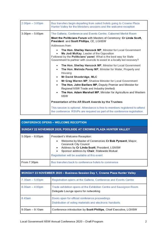
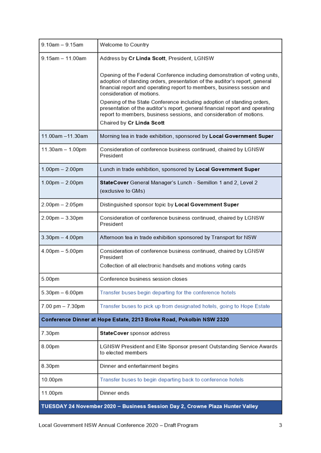
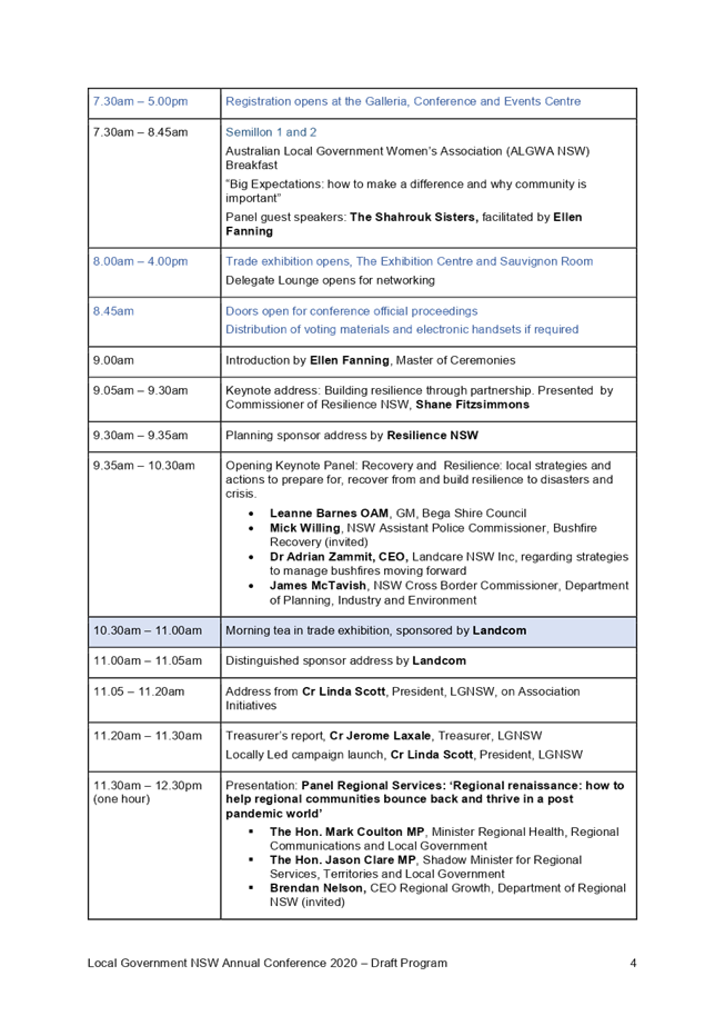
Local Government NSW Conference 2020
|
|
Strategic
Direction
|
Leading
through Collaboration
Strive for
best practice in all Council processes
|
|
File Ref
|
205990.2020
|
|
Report By
|
George
Georgakis - Manager Council and Executive Services
|
|
Approved
By
|
Andrew
Stevenson - Chief Strategy and Engagement Officer
|
The
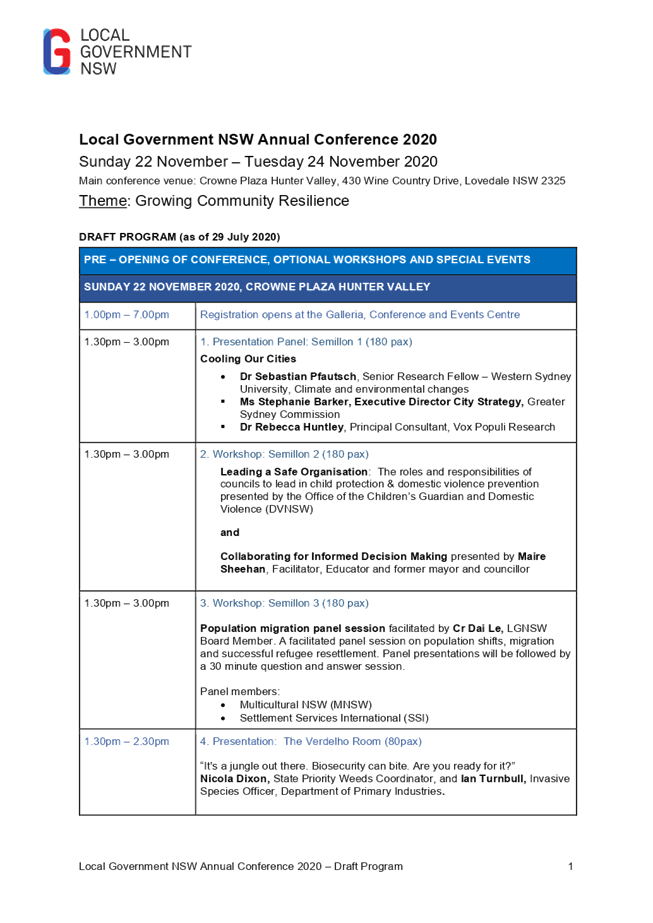
2020 Local Government NSW Annual Conference is scheduled to be held in the
Hunter Valley from Sunday 22 to Tuesday 24 November 2020.
The
report addresses proposed motions to be submitted to the Conference and
provides information in relation to voting delegates which Liverpool City
Council will be entitled to for voting on motions. The deadline for motions to
be submitted for the conference is 28 September 2020.
|
That:
1. Any Councillors who wish to attend the
2020 Local Government NSW Annual Conference notify the Councillor Support
Officer by 4 September 2020;
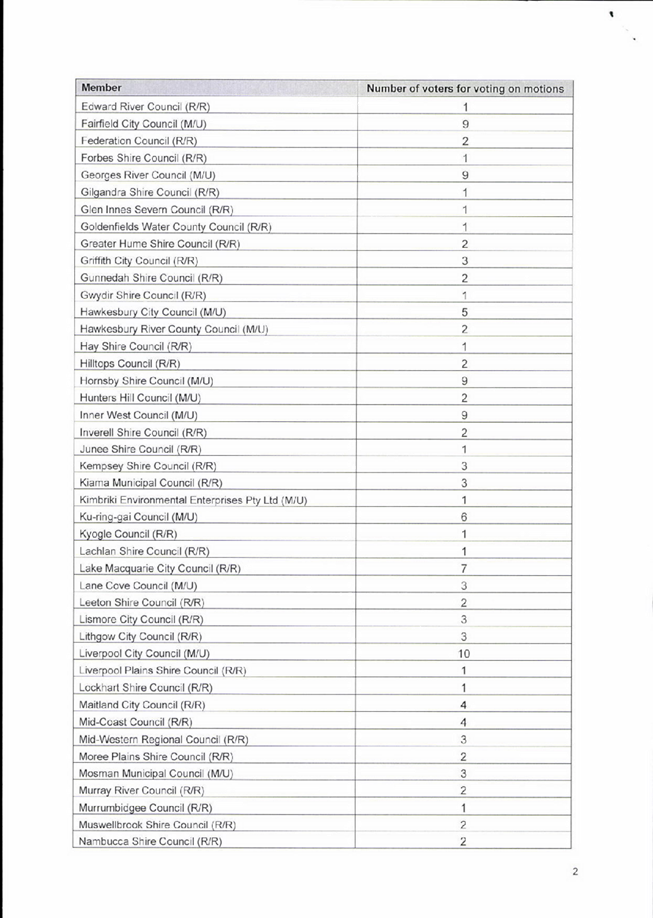
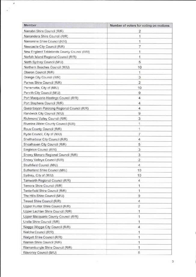
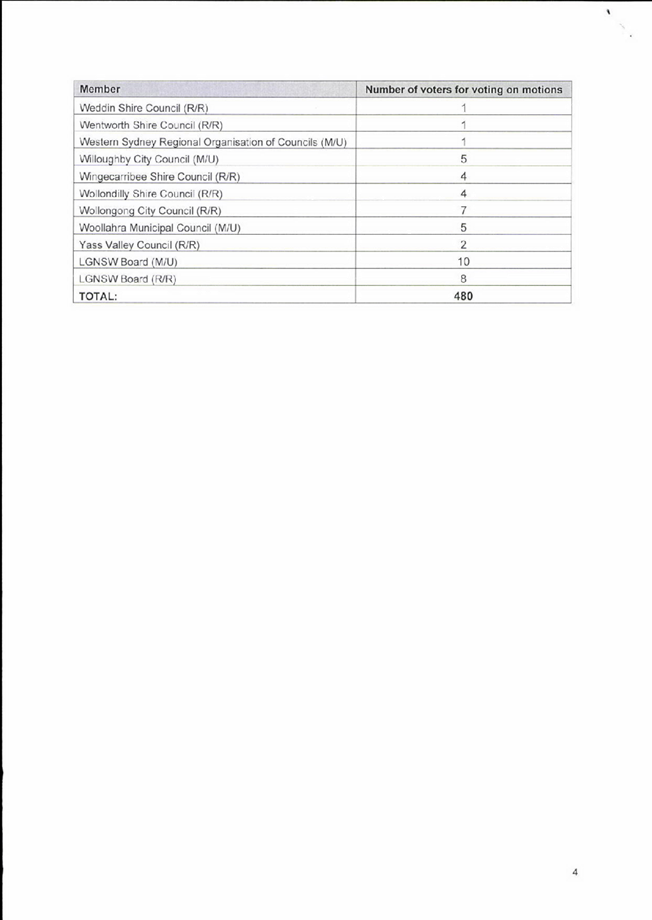
2. Council determine its voting delegates
for the Conference, noting that Liverpool City Council is entitled to 10
voting delegates for voting on motions and also noting that Councillor Hadid
is entitled to one vote as he is a Director of the Association; and
3. Endorse the motions as
outlined in the report to be submitted to the Conference.
|
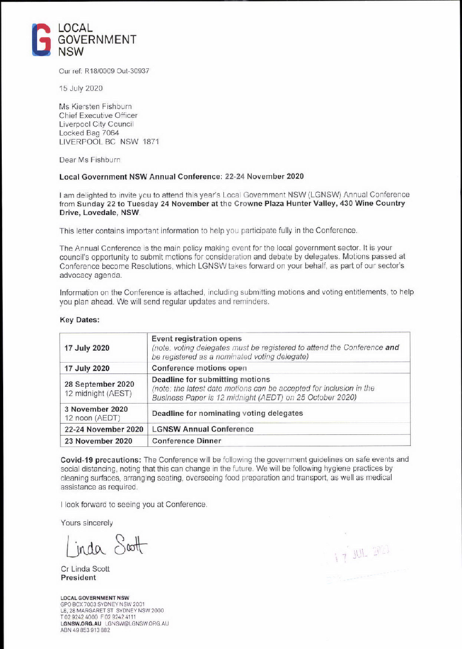
The 2020 Local Government NSW Annual
Conference is scheduled to be held at the Hunter Valley from Sunday 22 to
Tuesday 24 November 2020.
The Conference is the main policy making
event for the local government sector where issues are debated and motions put
forward for consideration by delegates.
This report addresses the determination of
voting delegates and the key issues to be submitted for consideration at the
Local Government (LGNSW) Annual Conference.
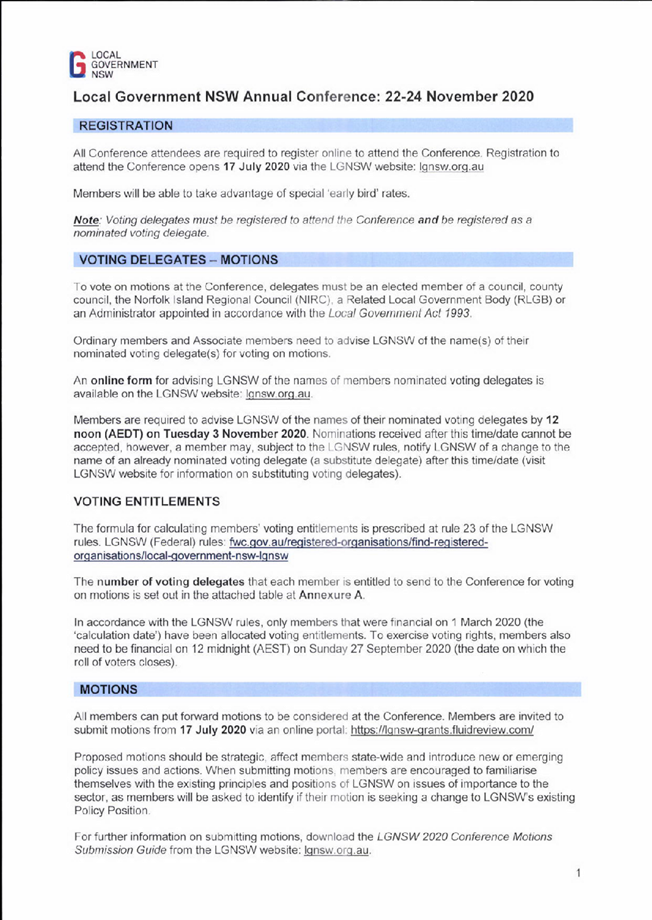
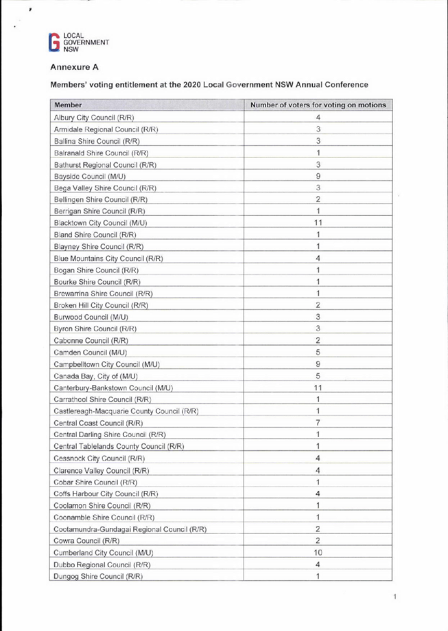
LGNSW have advised that Liverpool City
Council is entitled to the following:
- 10 voting delegates for voting on motions.
Note, Councillor Hadid is entitled to one
vote as he is a Director of the Association.
Council will need to determine its voting
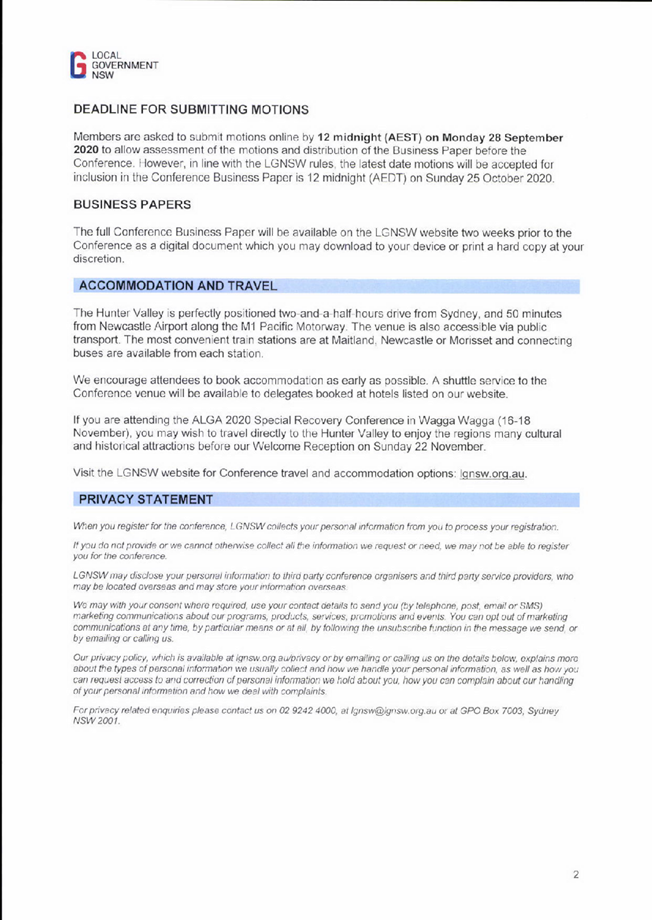
delegates and the deadline for nominating voting delegates is 3 November.
Correspondence from LGNSW is attached to
this report. The draft Conference Program is also attached.
LGNSW Board have resolved that motions will
be included in the Business Paper for the Conference only where they:
1. Are consistent with the objects of the
Association (See Rule 4 of the Association’s rules);
2. Relate to Local Government in NSW and/or
across Australia;
3. Concern or are likely to concern Local
Government as a sector;
4. Seek to advance the Local Government policy
agenda of the Association and/or improve governance of the Association;
5. Have a lawful purpose (a motion does not
have a lawful purpose if its implementation would require or encourage
non-compliance with prevailing laws);
6. Are clearly worded and unambiguous in
nature; and
7. Do not express preference for one or
several members over one or several other members.
Motions are to be submitted by 28 September
2020.
It is recommended that Council submit the
following motions on issues drawn from recent Council resolutions and feedback
from Councillors to be considered for inclusion in the Conference Business
Paper:
1. Sustainable Housing Development
That the NSW Conference advocate to the NSW Government
to amend the State Environmental Planning Policy (Exempt and Complying
Development Codes) to limit housing developments to cover no more than 40% of
block size in urban Developments excluding secondary developments.
2. Stray Cats in urban areas
That the NSW Conference advocate for:
· tighter restrictions on cat owners
(including that all cats to be microchipped and desexed) to be included in the
NSW Companion Animals Act 1998;
· Councils be funded to provide services that
identify stray cats that are not microchipped, nor desexed and found on the
streets, to be microchipped, desexed and housed until rehomed; and
· Changes be made to section 11 of the Prevention of
Cruelty to Animals Act 1979 (NSW) to permit the release of cats under a Trap
Neuter Return Program.
3. Fast track Western City Rail transportation
network
That the NSW Conference call on the State
Government to provide funding to fast track the Leppington to Western Sydney
Airport rail link extension and the Sydney Metro City and South West project
from Bankstown to Liverpool as well as funding for the Fifteenth Avenue Rapid
Transit Corridor project from Liverpool to Western Sydney Airport.
4. Koala Sanctuary and Wildlife hospital
That the NSW Conference advocate for the creation of a Georges River
National Park and establishment of a well-resourced wildlife hospital in South
West Sydney.
5. Renew Our Libraries Phase Two
That the NSW Conference
advocate for:
· a sustainable state funding model for the
ongoing provision of public library services; and
· Call for bi-partisan support for Consumer
Price Index (CPI) indexation of state funding for NSW public libraries, as well
as legislation of all elements of the 2019-20 to 2022-23 NSW state funding
model.
6. Hotel Liquor Licence Applications
That the NSW Conference:
· Advocates to NSW Government for increased
Local Government decision making in gaming machine provisions, including the changed
Local Impact Assessment Band that allows moving of or increase of poker
machines within the respective local government areas;
· Advocates to NSW Government for local
government’s Social Impact Assessments to be prioritised in
considerations relating to gaming machine provisions and determination of the
band assessment’s allocations; and
· Considers a policy position, where public
interest is in the forefront of all such decisions, including investigating
measures of non-association with alcohol and gambling industries.
7. Covid-19 related
· That the NSW Conference note the collapse in revenues and seek a
rates guarantee to ensure financial liquidity, financial assistance to maintain
existing employment levels and explicit inclusion of local government in any
future stimulus packages;
· Support LGNSW’s campaign to suspend
Fit for the Future (FFF) guidelines given current circumstances, including
writing to Minister for Local Government as appropriate; and
· Councils believe FFF targets and benchmarks
are now outdated and should be abandoned as councils will be increasingly
unable to meet targets and benchmarks during the pandemic.
8. Tolls in Sydney
That the NSW Conference request:
· a toll-free period on the M8;
and
· suggest the removal of the toll, or a cash
back scheme, or other measures to alleviate the financial burden on residents
on the old M5 East.
9. Standardisation
of speed limits for Schools, towns and CBDs throughout NSW
In feedback from Councillors
prior to finalising this report, Councillor Rhodes has proposed that the
following motion be submitted to the Conference:
That the NSW Conference:
Lobby for universal standardisation of speed limits in
school areas, and shopping areas in CBDs in towns and suburbs throughout NSW.
Current speed limits are different from suburb to
suburb in cities and towns throughout NSW, this is not only confusing but
dangerous to drivers and pedestrians alike.
Consistent speed zones throughout the state in these
situations will provide a safer and more consistent understanding of what the
road rules are, thereby minimising accidents and saving lives.
|
Economic
|
Costs in the order of $2,500 per delegate for
registration, travel, accommodation and meals which has been budgeted for in
the 2020/21 budget.
|
|
Environment
|
Raise community awareness and support action in relation to
environmental issues.
|
Social
|
Raise awareness in the community about the available services and
facilities.
|
Civic
Leadership
|
Act as an environmental leader in the community.
Provide information about Council’s services, roles and decision
making processes.
Operate a well-developed governance system that demonstrates
accountability, transparency and ethical conduct.
Actively advocate for federal and state government support, funding and
services.
|
|
Legislative
|
There are no legislative considerations relating to
this report.
|
|
Risk
|
The risk is deemed to be low and is
within Council’s risk appetite.
|
1. Letter
from LGNSW - invitation to attend LGNSW Conference 22 - 24 November 2020
2. Draft
Program - LGNSW Annual Conference 2020
|
0
|
|
CEO
01
|
Local
Government NSW Conference 2020
|
|
Attachment
1
|
Letter
from LGNSW - invitation to attend LGNSW Conference 22 - 24 November 2020
|
|
0
|
|
CEO
01
|
Local
Government NSW Conference 2020
|
|
Attachment
2
|
Draft
Program - LGNSW Annual Conference 2020
|

Ordinary Meeting
26 August 2020
Chief Executive Officer Report
|
CEO 02
|
Biannual Progress Report
|
|
Strategic
Direction
|
Leading
through Collaboration
Strive for
best practice in all Council processes
|
|
File Ref
|
209245.2020
|
|
Report By
|
Hiba Soueid
- Manager Corporate Strategy and Performance
|
|
Approved
By
|
Andrew
Stevenson - Chief Strategy and Engagement Officer
|
The
Biannual Progress Report provides an overview of Council’s progress on
the Principal Activities that were scheduled for the January to June 2020
period. This is reported against the Delivery Program 2017-2022 and Operational
Plan 2019-2020.
This
is the second and final Biannual Progress Report for 2019-20 and has been
prepared in line with the Office of Local Government Integrated Planning and
Reporting Guidelines
|
That Council notes and receives the Biannual Progress
Report which outlines the progress of Principal
Activities detailed in the Delivery Program 2017-2022 and Operational Plan
2019-2020.
|
On 26 April 2017, Council adopted the
Community Strategic Plan, Our Home, Liverpool 2027. Our Home,
Liverpool 2027 outlines the community’s vision and priorities for
Liverpool. The Plan was developed after extensive engagement with the community
and contains four key directions for the future of Liverpool. These directions
guide Council’s operations and service delivery for the next ten years.
Council’s Delivery Program 2017-2022
and Operational Plan and Budget 2019-2020 outline Council’s commitment to
the community. The combined document details 107 Principal Activities that
Council has committed to delivering.
Section 404 (5) of the Local Government
Act (1993) requires the Chief Executive Officer (CEO) to ensure that a
progress report is provided to Council at least every six months. It should
include information and updates on the Principal Activities that have been
detailed in the four-year Delivery Program. This allows Council and the public
to monitor progress.
During the January to June 2020 reporting period, Council
experienced several natural disasters, including bushfires, floods and the
current COVID-19 pandemic. These uncertain times bought about continuous and
rapid change in Council’s daily operations including the cancellation of
major events, the closure of many of Council’s facilities and
mobilisation of staff to work from home. This has impacted the local community,
economy and Council’s operations and financial performance.
Council’s priority during this period was the
safety of residents and staff. Council followed federal and state government
advice and developed local initiatives tailored to meet the needs of the
community. This included a comprehensive package to support local businesses affected by
the COVID-19 pandemic and hardship provisions for ratepayers.
By the end of
June 2020, 69% of actions in the Delivery Program and 2019-20 Operational Plan
were on track or completed. Of the remaining actions, 31% were affected by the
COVID-19 pandemic. The attached report provides detailed information on each of
the 107 Principal Activities detailed in the Delivery Program 2017-2022.
Governance
|
The Delivery Program and Operational Plan sets the direction for
Council’s strategic agenda, including all economic, environmental,
social and civic leadership requirements.
|
Legislation
|
The Delivery Program and Operational Plan have been
developed in line with the Local Government Act 1993
In particular Section 404 (5) of the Local Government Act states:
“The
general manager must ensure that regular progress reports are provided to the
council reporting as to its progress with respect to the principal activities
detailed in its delivery program. Progress reports must be provided at least
every 6 months.”
|
|
Risk
|
The risk is deemed to be High. Failure to provide
regular progress reports to the council with respect to the principal
activities detailed in its delivery program at least every 6 months may
result in non-compliance with the above legislation and may result in
enforceable action by the Office of Local Government, Planning Policy.
|
1. Biannual
Progress Report January-June 2020 (Under separate cover)
Ordinary Meeting
26 August 2020
City Economy and Growth Report
|
EGROW 01
|
Draft
Warwick Farm Racing Precinct Structure Plan, Planning Proposal and Local
Contributions Plan
|
|
Strategic Direction
|
Strengthening and Protecting our Environment
Exercise planning controls to create high-quality, inclusive urban
environments
|
|
File Ref
|
144667.2020
|
|
Report By
|
Graham Matthews - Senior Strategic Planner
|
|
Approved By
|
David Smith - Acting Director City Economy and Growth
|
At
its meeting of 11 December 2019, Council resolved (EGROW 02) to direct the CEO
to engage consultants to prepare a structure plan, planning proposal and
developer contributions plan for the Warwick Farm racing precinct to support a
rezoning of the precinct.
This
report presents the draft structure plan, planning proposal and local
contributions plan, pursuant to the above Council resolution for
Council’s consideration.
A
Councillor briefing on the draft plans was held on 1 July 2020. Responses to
questions from Councillors taken on notice at the briefing is provided in this
report.
It
is recommended that Council place the draft structure plan, planning proposal,
and local contributions plan and supporting documents on public exhibition for
28 days, pursuant to the Liverpool Community Participation Plan 2019.
Following
public exhibition, a further report will be prepared for Council’s
consideration responding to submissions received, any amendments proposed, and
to endorse the planning proposal for submission to the Department of Planning,
Industry and Environment for a Gateway determination.
|
That Council:
1. Notes the advice of the Liverpool Local
Planning Panel;
2. Notes that a feasibility
study will be completed as recommended by the Liverpool Local Planning Panel;
3. Places the draft structure plan, planning
proposal and local contributions plan on public exhibition, pursuant to the
Liverpool Community Participation Plan 2019 for 28 days; and
4. Receives a further report,
following public exhibition, detailing any submissions received and any amendments proposed to the structure
plan, planning proposal and/or local contributions plan.
|
Background
At its 11 December 2019 meeting,
Council resolved (EGROW 02) to direct the CEO to engage consultants to prepare
a structure plan for the Warwick Farm racing precinct.
Council resolved that the structure
plan was to address the following:
· the appropriate density of development in
the precinct, including built form; and
· building typologies including height and
floor space ratio development standards for:
i. open space, community and recreation
facilities to support urban renewal;
ii. likely traffic and transport upgrades;
iii. amenity issues;
iv. flooding considerations; and
v. development contributions.
The resolution went on to establish the following
considerations for the preparation of the structure plan:
Directs the CEO to allocate
funding from general funds and to prepare a structure plan for the Warwick Farm
Racing precinct and a planning proposal to support a rezoning of the Warwick
Farm racing precinct from Scrivener Street to Hume Highway to Governor Macquarie
Drive relevant to B4 with mixed business noting that zoning is consistent with
the State Governments planning advice to maximise densities close to rail
stations and this precinct is immediate to the Warwick Farm Railway station;
and
a) notes the AEC Report June 2017 specifically
27.3
“27.3 should the horse training stabling
functions of Munday Street Precinct be viably relocated to the racecourse,
opportunities arise for Munday Street Precinct and Lot 1 to collectively
deliver a masterplanned outcome that incorporates a range of housing types,
required urban and retail amenity as well as meet social/community
infrastructure need”, and
b) noting that there is a local Warwick Farm
School and 5 other Schools already within the Liverpool CBD that are all within
walking distance of this precinct and
c) that the precinct has the most expensive
recreational park in the LGA that could be made open to the public and that
this precinct is also within walking distance to the open space surrounding The
Georges River, and
d) that existing jobs in this precinct will be
supported by B4 zoning as training facilities will be relocated on track, and
work force will still live in the area close to their employment through the B4
zoning, and
e) that the area below Scrivener Street to
Georges River is already zoned industrial and is best situated to be renewed as
a hi-tec education hospital and technology park, which will also provide job
opportunities to support the increase in density in the B4 zoning and
f) that there is already employment
opportunities in the hospital universities race track and The Inglis Hotel and
function precinct and in the industrial site, and also at a shopping centre
less than 100 metres from the Warwick Farm racing precinct
g) that Moore Point and Hargrave Park will be
also be identified on the structure plan as the River Precinct separate from
the Warwick Farm Racing Precinct, and
h) as the River Precinct plans for Moore Point
and Hargrave Park already exist there is no need to allocate funding for new
plans.
The Council resolution also required that:
9. The
report to be submitted to the May 2020 Council meeting.
A report to the 27 May 2020 Council meeting
provided an update on the progress in drafting the structure plan. Council
resolved (EGROW 01 of 27 May 2020):
That Council:
1. Receives and notes this report; and
2. Receives a further report on the draft
structure plan, draft planning proposal and draft contributions plan for the
Warwick Farm racing precinct at the 26 August 2020 Council meeting.
Draft Warwick Farm Racing
Precinct Structure Plan
As noted in the report to
Council of 27 May 2020, Conybeare Morrison International were engaged by
Council as the lead consultant to prepare the structure plan, planning proposal
and amendment to the Liverpool Contributions Plan 2009. The structure plan has
been prepared in line with the requirements of Council resolution EGROW 02 and
EGROW 09 of 11 December 2019.
The precinct has an area of approximately
28.4 hectares and is bounded by the Hume Highway to the northwest, the railway
corridor to the west, Priddle Street to the south, Horseshoe Pond to the east
and Governor Macquarie Drive to the northeast. It is comprised of land zoned R2
Low Density Residential, R3 Medium Density Residential, RE1 Public Recreation
(Rosedale Park) and RE2 Private Recreation.
A recent aerial photograph of the Warwick
Farm racing precinct (see Figure 1), illustrates the characteristic
low-scale residential development existing within the precinct. It also shows
the widespread use of the precinct for thoroughbred horse training/stabling
facilities.
Figure 1: Aerial view of the Warwick Farm
precinct
NB: 240 Governor Macquarie Drive, depicted
at the top of the picture, is not included among the lots subject to the
planning proposal.
Source: Nearmap 15 April
2020
The northernmost lot, 240 Governor
Macquarie Drive, is currently zoned B5 Business Development. Council separately
provided in principle support to the rezoning of that lot to part B4 Mixed Use
and part R4 High Density Residential at its 11 December 2019 meeting (EGROW 09).
This planning proposal was lodged with the Department of Planning, Industry and
Environment in February 2020 for a Gateway review. Figure 2 below, illustrates the existing zoning
applying to the Warwick Farm racing precinct.
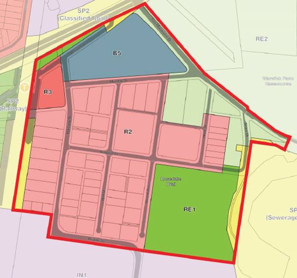
Figure 2:
Warwick Farm existing zoning
Source:
Conybeare Morrison International
The draft structure plan
(depicted in Figure 3 below) provides a conceptual framework for the
redevelopment of the Warwick Farm racing precinct for a mix of uses, including
B4 zone in accordance with Action 10.2 of the Liverpool Local Strategic
Planning Statement (LSPS), Connected Liverpool 2040.
The draft structure plan
envisages the rezoning of the Warwick Farm racing precinct for the following
uses:
· B4 Mixed Use in the west of the precinct, in the immediate
vicinity of Warwick Farm train station;
· R4 High Density Residential in the east and south; and
· RE1 Public Recreation in the lowest-lying land in the precinct in
the east and south, generally within the Warwick Farm Sewage Treatment Plant
odour buffer area and adjacent to Rosedale Park and Horseshoe Lagoon.
The structure plan envisages
that the redevelopment of the Warwick Farm racing precinct (including 240
Governor Macquarie Drive) will deliver in excess of 200,000 m² of
residential floor space, equating to over 2,200 dwellings and 25,000 m² of
commercial floor space.
The structure plan also
envisages the development of a pedestrian footbridge, to increase the
connectivity of the precinct with Liverpool city centre. The footbridge would
link the precinct with Hart Park and provide easy access to the employment and
amenities of Liverpool city centre. It is depicted on Figure 3 below.
The structure plan also depicts
the proposed route for the Manning Street bypass, which would divert heavy
vehicles from the industrial land to the south, to the south and east of
Rosedale Park and via Shore Street to and from Governor Macquarie Drive. An alternative
bypass route, utilising existing roads including Stroud Avenue, National Street
and Shore Street is discussed in response to questions raised at the Councillor
briefing, below.
The proposed bypass has been
the subject of previous Council’s resolutions over the years and is a top
priority for Council as resolved by Council in December 2019. The local
contributions plan will provide an additional funding source for the
construction of the bypass.
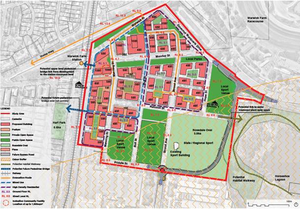
Figure 3: Draft Warwick Farm structure plan NB: 240 Governor Macquarie
Drive, located the top of the picture, is not included in land subject to
the planning proposal. Source: Conybeare Morrison International
Constraints
The structure plan seeks to
provide a framework for the urban redevelopment of the Warwick Farm racing
precinct, while responding to the environmental constraints impacting the
precinct, including the potential for flooding and land use conflict (primarily
with industrial heavy vehicles, in addition to the impacts of odour from the
adjacent Warwick Farm sewage treatment plant).
In consideration of the NSW
Flood Prone Land Policy, the height of the ground floor of all new development
must be at the 1 in 100-year flood level (1% AEP), in addition to 0.5m
freeboard (the flood planning level). The 1% AEP applying to the Warwick Farm
racing precinct is 8.5m AHD, meaning that the ground floor of all new
development must be no lower than 9m AHD. Additionally, to ensure safe
evacuation in case of flood, the height of all internal roads must be increased
to the 1% AEP (i.e. 8.5m AHD), with a gradual increase in the height of
internal roads approaching Manning/Warwick Streets, providing a safe route for
evacuation from the precinct west along the Hume Highway, towards Liverpool
city centre.
All filling of flood-prone land
must be balanced by compensatory excavation, to ensure there are no adverse
flooding impacts off-site due to a loss of flood storage. Hence, the land
filled on development sites must be balanced with the same volume of excavation
elsewhere in the precinct.
In order to fill land close to
the Warwick Farm station for redevelopment, the structure plan proposes that
land furthest from the station must be excavated and preserved as public open
space, so as not to reduce the overall flood storage capacity of the precinct
as a whole. As a result, the structure plan seeks to rezone some land currently
zoned RE2 Private Recreation and R2 Low Density Residential to RE1 Public
Recreation, to enable acquisition of this land by Council to provide requisite
land for flood storage.
Figure 3 above depicts the draft
structure plan (also included in Attachment 6). Most of the R2 Low
Density Residential land to be rezoned RE1 Public Recreation is also within the
Warwick Farm Sewage Treatment Plant Odour Buffer Area. According to the
Liverpool Local Strategic Planning Statement (LSPS), odour sensitive
development (including residential development) should be avoided in this area.
Manning Street bypass road
The urban redevelopment of the
Warwick Farm racing precinct is also constrained by traffic impacts. Heavy
vehicles servicing the Scrivener Street industrial precinct to the south,
currently travel through the precinct via Munday, Manning and Priddle Streets.
The passage of heavy vehicles through the Warwick Farm racing precinct creates
considerable land use conflict, which would only be exacerbated once the
precinct is developed for high density residential uses.
The planning proposal does not
seek to rezone land for the planned Manning Street bypass (providing a direct
route for heavy vehicles to and from the Scrivener Street precinct and Governor
Macquarie Drive) to SP2 (Local Road), pursuant to Council resolution EGROW 11
of 25 March 2020. The rezoning of the Manning Street bypass road is
unnecessary, as all existing/proposed zones over which the bypass road is
planned to traverse, already permit the development of "Roads".
In addition, owing to
additional environmental constraints associated with the Horseshoe Lagoon
coastal wetland (which is intersected by the proposed route of the bypass),
seeking to rezone the Manning Street bypass road SP2 (Local Road) may
significantly delay the finalisation of the planning proposal as a whole. As
noted in the planning proposal:
The proposed route of the
road currently traverses through land zoned RE1 Public Recreation, RE2 Private
Recreation and SP2 Sewerage System. As noted above, all these zones permit
“roads” as a land use which is permissible with the consent of
Council. The bypass road does therefore not require rezoning and can be
delivered if further ecological investigations confirm it could be approved
under the Coastal Management SEPP.
The rezoning of the bypass
route into the Planning Proposal requires justification for the change from the
existing zoning. It is recommended that ecological advice be sought to confirm
the road could be approved meeting the specific requirements of the Coastal
Management SEPP and that discussions occur with Crown Lands and if required Sydney
Water to ensure owners consent will be forthcoming and any additional
acquisition requirements. This will avoid delays with adopting an SP2 Local
Road in this report that requires further investigations. The draft Local
Contributions Plan has included an amount for this land to be acquired subject
to the above occurring. Provision of the Manning Street bypass road, as an infrastructure
improvement, in addition to proposed widening of Governor Macquarie Drive and
the development of additional shared paths, will effectively mitigate traffic
impacts.
(Planning proposal,
Attachment 1, page 17)
Opportunities
While the structure plan
applies to the Warwick Farm racing precinct as a whole, Council resolved to
rezone the ‘Masters’ site (240 Governor Macquarie Drive, Warwick
Farm) separately, pursuant to EGROW 09 of 11 December 2019. As noted in the
report to Council EGROW 01 of 27 May 2020, Council forwarded the planning
proposal to rezone 240 Governor Macquarie Drive to DPIE in February 2020. DPIE
is yet to issue a Gateway determination at the date of writing this report.
For the purposes of the
structure plan, the final built form for 240 Governor Macquarie Drive is
assumed to be identical to that put forward in the proponent's Urban Design
Plan. Final development outcomes for 240 Governor Macquarie Drive are assumed
to be as follows:
· Floor space ratio (FSR) 3:1;
· Approximately 830 dwellings; and
· 5000 m² of commercial floor space.
Taking account of development
outcomes at 240 Governor Macquarie Drive and considering the Warwick Farm
racing precinct as a whole, the structure plan projects the development of
2,252 dwellings and over 24,400 m² of commercial floor space. In addition
(and noting flooding/odour constraints described above), the structure plan
also projects the zoning of 46,829 m² of land RE1 Public Recreation for
local open space (16.5% of the site area), in addition to Rosedale Oval, which
is 49,927 m² and reserved for district open space purposes.
Flood, Traffic and Social
Impact Assessments
Conybeare Morrison
International has engaged a team of consultants to make assessments of the
potential impacts of the proposed redevelopment and to make recommendations to
mitigate those impacts. These sub-consultants include:
· WMA Water, stormwater and flooding engineers;
· SCT Consulting, traffic and transport engineers; and
· CRED Consulting, social infrastructure planning consultants.
Flood mitigation
As noted above, the Warwick
Farm racing precinct is situated on a floodplain. Much of the land is situated
below the 1% AEP level and would be inundated in a one in 100-year flood. Urban
redevelopment of the precinct will require the raising of the land of
development sites to the flood planning level (1% AEP level +500 mm freeboard).
This will require compensatory excavation, to ensure no loss in flood storage
throughout the precinct.
WMA Water has prepared a Flood
Impact Assessment (Attachment 2) which recommends appropriate cut and
fill to facilitate the proposed redevelopment. Mitigating measures proposed
include the following:
· the rezoning of land for recreational purposes, its acquisition by
Council and excavation for compensatory flood storage purposes;
· increasing the height of internal roads to the 1% AEP level; and
· developing a flood evacuation path via Manning/Warwick Streets to
the Hume Highway and west to the Liverpool city centre.
Much of the additional land to
be rezoned RE1 Public Recreation is also located within the Warwick Farm Sewage
Treatment Plant Odour Buffer Area, which according to the Liverpool Local
Strategic Planning Statement (LSPS), odour sensitive development (including
residential development) should be avoided.
Traffic mitigation
SCT Consulting has prepared a
Traffic Impact Assessment (TIA) (Attachment 3) in support of the
proposed rezoning of the Warwick Farm racing precinct. The TIA estimates the
impact of redevelopment on the surrounding road network and recommends road
upgrade works to mitigate the impacts, including intersection improvements, the
widening of Governor Macquarie Drive and the development of additional shared
paths to improve access to the Georges River foreshore. The TIA also models the
proposed Manning Street bypass, which will divert heavy vehicles around the
precinct, to and from Governor Macquarie Drive.
While the SCT TIA has estimated
the cumulative impacts of development elsewhere in the vicinity (such as Moore
Point and Moorebank East), Transport for NSW (TfNSW) have stated that they will
require the integration of the Warwick Farm TIA into a broader transport impact
assessment underway for the Liverpool Collaboration Area, considering the
impacts of all planned future development on the district road network.
It is expected that TfNSW will
require the integration of the SCT TIA with the broader transport study, after
the issue of a Gateway determination.
Social impacts
Social planning consultancy
CRED Consulting were contracted by Conybeare Morrison International to draft
the Community Needs Assessment (Attachment 4). The Community Needs
Assessment recommends that the following social infrastructure be provided to
support the urban redevelopment of the Warwick Farm racing precinct:
· A 1000 square metre multipurpose community facility in the
vicinity of Warwick Farm railway station;
· 9.5 ha of open space;
· Provision of between 5-10% affordable housing in new development;
· Improved pedestrian/cycling connections; and
· A range of other, more minor, social infrastructure improvements.
The recommendations of the
Community Needs Assessment have been addressed in detail in Section 3.9 of the
planning proposal.
Planning Proposal and Liverpool
Contributions Plan 2009 Amendment
GLN Planning were subcontracted
by Conybeare Morrison to draft the planning proposal (Attachment 1)
pursuant to the uses depicted in the structure plan. Studies undertaken in
support of the planning proposal also assess the impact of increased
development on the surrounding road network, flooding impacts and social
infrastructure requirements, including provision of open space.
The planning proposal seeks to
rezone land in the Warwick Farm racing precinct (excluding 240 Governor
Macquarie Drive, for which a planning proposal has already been lodged) from R2
Low Density Residential, R3 Medium Density Residential and RE2 Private
Recreation; to B4 Mixed Use, R4 High Density Residential and RE1 Public
Recreation.
The planning proposal also
seeks to amend development standards applying to land in the Warwick Farm
racing precinct. It seeks to increase the maximum height of buildings for lots
to be redeveloped, from 8.5 m to between 14m and 49 m. It also seeks to
increase floor space ratio (FSR) across lots to be redeveloped from 0.5:1 to
between 1.3 and 3.6:1.
The structure plan projects the
development of 2,252 dwellings and 24,400 m² of commercial floor space
across the Warwick Farm racing precinct. 500 to a maximum of 830 dwellings
could be developed at 240 Governor Macquarie Drive, with a further 1,422
developed elsewhere in the precinct.
In order to facilitate the
development of the projected 2,252 dwellings and 24,400 m² of commercial
floorspace, the planning proposal foreshadows the development of supporting
infrastructure for the purposes of flood mitigation, to provide social
infrastructure for a much larger population and to alleviate traffic impacts
(including the development of the Manning Street bypass, diverting heavy
vehicles around the precinct to be developed), in particular.
In order to fund required
infrastructure, an amendment to the Liverpool Contributions Plan 2009 has been
drafted by GLN planning. The proposed Contributions Plan amendment (Attachment
5) has been drafted to fairly apportion the cost of infrastructure and to
permit the rollout of infrastructure to proceed as development takes place.
A detailed merit assessment of
the planning proposal for the proposed rezoning of the Warwick Farm racing
precinct, was made in the officer's report to the Liverpool Local Planning
Panel. The officer's report determined that the proposal has both strategic and
site merit. The report is attached as Attachment 7.
Liverpool Local Planning Panel
(LPP) advice
According to the requirements
of the Ministerial Direction, a merit assessment of the planning proposal was
presented to the LPP at its 27 July 2020 meeting. The advice of the LPP (Attachment
8) is as follows:
The Panel members have
familiarised themselves with the site and have been provided with the Council
officer’s report and the documents supporting the planning proposal. The
Panel had the benefit of a briefing from Council’s staff and
Council’s consultant team for the project.
The Panel accepts that the
planning proposal may meet the strategic merit test given the Greater Sydney
Commission’s assurance of Council’s Local Strategic Planning
Statement.
However, the Panel is not
satisfied that the proposal meets the site-specific merit test.
The Panel does not support
the planning proposal proceeding to a gateway determination at this stage. The
Panel recommends that the planning proposal not proceed because the following
matters have not been satisfactorily addressed:
1)
Updating of the Flooding Assessment to have regard to the 2020 Georges River
Flood Study (BMT, January 2020) and its implications for this site;
2)
Preparation of a development feasibility study having regard to the need for
consolidation of fragmented sites, flood mitigation works, open space
acquisition, the truck bypass route, pedestrian links across the railway and
the proposed development yield;
3) A
report addressing whether, given the cap of 18,800 additional dwellings for
Liverpool Collaboration Area Place Strategy, this site is the optimum location
for the provision of additional housing given the constraints of the site
including flooding and difficulty of evacuation; and
4)
Further analysis of the potential environmental impacts of the proposed truck
bypass route and the changes to ground levels for flood mitigation having
regard to vegetation, acid sulfate soils and water table level.
Response to LPP advice
The proposal to rezone the
Warwick Farm racing precinct clearly has strategic merit as it flows from a
direction of the Liverpool LSPS, which was granted assurance by the Greater
Sydney Commission (GSC) in March 2020 and is in force. The strategic merit of
the proposal is demonstrated in the officer's report to the LPP.
With regard to site-specific
merit, Council officers’ response to the concerns of the LPP are as
follows:
1) It is not
necessary to update the Flooding Assessment to have regard to the 2020 Georges
River Flood Study, as advised by the LPP.
The currently adopted Georges River Floodplain
Risk Management Study and Plan 2004 (FRMP) was developed by eight participating
councils sharing the catchment of the river including Liverpool, Bankstown,
Fairfield, Campbelltown and Sutherland Councils. The adopted flood levels in
the FRMP are being widely used by all participating councils for planning and
development of flood prone lands in the catchment of the river.
Recently, the Georges River Floodplain Risk Management
Committee (which includes the eight councils, the DPIE, SES and the Georges
Riverkeeper) initiated a review of the FRMP 2004, which is being led by
Fairfield City Council.
The first stage of the works has commenced, and a
consultant has been engaged and involves a review of existing data and data
collection in accordance with the guidelines of the NSW Floodplain Development
Manual. Following completion of the current works, a detailed flood study
will be undertaken and subsequently the FRMP will be reviewed and updated. It
is expected that the review of the Georges River FRMP will be completed by the
2022-23 financial year subject to grant funding approval.
Regarding the recent Georges River Flood Study (BMT, January
2020), the Study was
undertaken jointly by Liverpool City Council (LCC) and Canterbury Bankstown
City Council (CBCC). The primary objective of the flood study was to develop a
flood model with new flood modelling techniques (2D TUFLOW model) to assess the
impacts on flood behaviour due to recent developments that have occurred within
Liverpool and Bankstown catchment areas since 2004.
The 1% AEP (or 1 in 100 year)
flood levels in the new model are generally consistent with the currently
adopted flood levels across the river. It should be noted that 1% AEP flood
level is the basis of development controls for residential and commercial
developments across the LGA, as explained in Clause 7.8 of LLEP 2008.
Variation was observed in the
probable maximum flood levels (PMF) in the 2020 model. However, as PMF is not
the development control criteria for residential and commercial developments
and is predominantly used for flood evacuation consideration, it was agreed
that the model will be used for flood impact assessment for new developments
but that both councils will continue to use the adopted flood levels in the
Georges River FRMP 2004, until the current review of the FRMP is completed and
adopted by councils.
Accordingly, flood impact
assessment of the proposed Warwick Farm structure plan was undertaken based on
the adopted flood levels of the Georges River FRMP 2004.
2) With respect to the recommendation of the LPP to prepare a
feasibility study, Conybeare Morrison International, the consultants who
prepared the Warwick Farm racing precinct structure plan and other documents,
have provided Council with a fee proposal for the preparation of a feasibility
study. The feasibility study would make recommendations as to any required
amendments to proposed development standards that would be required to ensure
the feasibility of the proposed rezoning.
Council will complete the feasibility
study at the same time that the draft structure plan and supporting
documentation is on public exhibition. A subsequent report to Council would
both respond to submissions received in addition to outlining any proposed
amendments to the structure plan, planning proposal and local contributions
plan required to ensure the feasibility of the proposal.
3) With respect to the LPP’s comment about whether this
precinct is the optimum location for additional housing, it is the professional
opinion of Council planning staff, that an additional report, demonstrating the
merits of the proposed rezoning of the Warwick Farm racing precinct, is not
required. The planning proposal and supporting documents and the officer's
report to the LPP clearly demonstrate that the proposal has both strategic and
site-specific merit and addresses site constraints including flooding and
evacuation and includes appropriate mitigation measures that ensure that the
flood-prone land may be developed safely and in accordance with the NSW
Floodplain Development Manual.
4) The proposed Manning Street bypass is not a matter under
consideration regarding the planning proposal. As noted above, all
existing/proposed zones along the route of the proposed bypass permit the
development of "Roads" with consent. The environmental impacts of the
proposed Manning Street bypass would be considered as part of a Review of
Environmental Factors (REF) or Environmental Impact Statement (EIS), separately
prepared by Council at such time as it resolves to proceed with the
construction of the bypass road.
With respect to "changes to ground levels for flood
mitigation having regard to vegetation, acid sulfate soils and water table
level", it is be
noted that:
i. None of the lots identified for
flood mitigation purposes (i.e. excavation for compensatory storage purposes)
are currently vegetated. All are currently developed for horse
training/stabling purposes to varying degrees.
ii. With respect to planning proposals,
Ministerial Direction 4.1 Acid Sulphate Soils states:
A relevant planning
authority must not prepare a planning proposal that proposes an intensification
of land uses on land identified as having a probability of containing acid
sulfate soils on the Acid Sulfate Soils Planning Maps unless the relevant
planning authority has considered an acid sulfate soils study assessing the
appropriateness of the change of land use given the presence of acid sulfate
soils. The relevant planning authority must provide a copy of any such study
to the Director General prior to undertaking community consultation in
satisfaction of section 57 of the Act (emphasis added).
While an acid
sulfate soil study, assessing the appropriateness of the proposed compensatory
excavation may be required by DPIE, this need not be undertaken until after the
issuing of a Gateway determination, before commencing community consultation.
Nothing in the Ministerial Direction prevents Council forwarding the proposal
to DPIE for a Gateway determination, prior to commissioning an acid sulfate
soils study, which would be both costly and intrusive to undertake.
Meanwhile, should
any excavation be undertaken on acid sulfate liable soils in the precinct, any
works would be required to comply with Clause 7.7 of LLEP 2008.
iii. There are no specific LEP
requirements which deal primarily with water table levels. It is noted that
Clause 7.7 (2) of LLEP 2008 requires development consent for works with respect
to Class 5 Acid Sulphate Soils, where:
Works within 500 metres
of adjacent Class 1, 2, 3 or 4 land that is below 5 metres Australian Height
Datum by which the watertable is likely to be lowered below 1 metre Australian
Height Datum on adjacent Class 1, 2, 3 or 4 land.
Any potential for excavation to
impact the water table could therefore be considered as part of an acid sulfate
soil study, should that be required as a Gateway condition by DPIE pursuant to
Ministerial Direction 4.1, as discussed above.
According to the requirements
of State Environmental Planning Policies and Ministerial Directions, as noted
in the planning proposal, no additional analysis/studies need be undertaken,
prior to submitting the planning proposal to DPIE for a Gateway determination.
LEP Review Funding
As advised in a memo to
Councillors dated 24 June 2020, the DPIE has agreed to allow Council to use LEP
review funding, to offset the costs of preparing the Warwick Farm racing
precinct structure plan and related documents. The agreement requires that
Council consult with public authorities including the Greater Sydney Commission, DPIE and TfNSW.
Should Council resolve to
publicly exhibit the structure plan, planning proposal and contributions plan
according to the requirements of the Community Participation Plan 2019, it is
proposed that Council staff will consult with public authorities during that
period and respond to any submissions received in the foreshadowed report to
Council.
Councillor briefing and
response to questions
On 1 July 2020, a briefing for
Councillors was held. Questions taken on notice and the response from staff and
consultants, are detailed below:
1. A question was raised regarding whether reducing the
amount of open space provided to land within the odour buffer would halve
acquisition costs. It was also queried if an opportunity exists to provide
compensatory flood storage around the site rather than on the site.
Response:
Open Space and Compensatory Storage
· The quantum of open space in the Structure
Plan is that required for the future population envisaged by the Structure Plan
presented to Council. Any substitution of open space by residential development
is likely to increase the need for additional open space or an acceptance that
Council will reduce the standard provision of open space as a means to reduce
contributions.
· The odour buffer to the sewerage works
means that for the most part the required open space can sit within the buffer
area, where it is recommended that residential development does not occur.
· Figure 4, below, shows the odour buffer superimposed over the
Structure Plan and in turn those areas of open space not affected by this
constraint. These areas are bordered in red and discussed below.
· There are a small number of areas nominated
for open space outside the odour buffer. These include:
- Open space areas to the north of the buffer
zone bordered by the proposed bypass road as it aligns back to Shore Street and
Governor Macquarie Drive. The conversion of this land to residential would be
in conflict with the reason for the proposed bypass road to take industrial
traffic out of and from travelling in front of residential zones.
- Open space areas to the west on the corner
of Stroud Avenue and National Street which abuts the proposed alternative
bypass route. There may be some scope to consider zoning this land for High
Density Residential purposes, but only if Council is agreeable to reduced open
space provision. If the proposed alternative bypass route is realised,
then the orientation of development of this land must be carefully considered
to avoid conflicts with truck traffic and noise attenuation measures would also
be required.
- Land adjacent to Manning Street near the
corner of Priddle Street. This is a small irregular area outside the
buffer. It would provide a marginal increase of two lots to add to the
Structure Plan for residential use.
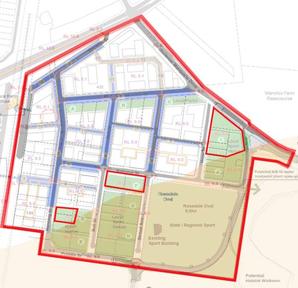
Figure 4: Lots currently designated
for open space, which may be developed for residential purposes
Source: Conybeare Morrison
International
· The Structure Plan has included the filling
of land including roads to provide a flood evacuation route. At least
some of this material can be taken from the proposed open space land as part of
its embellishment.
· The quantum of land proposed for open space
is sufficient to provide a source of fill and in turn excavation to ensure
compensatory storage required prevent flood impacts elsewhere in the flood
catchment. There is some economy in being able to undertake the
earthworks for the embellishment of the open space including also reducing
cartage costs to that material suitable for filling the land.
· A reduction in the quantum of open space
could lead to either further (deeper) excavations of these areas or
compensatory storage off site and outside the Precinct. Deeper excavation will
ultimately create further issues in draining these areas, encountering acid
sulfate soils and delivering appropriate landform for future recreation
activities.
Providing land for flood mitigation
"off-site"
2. A question was also asked whether it was possible to
consider providing land for flood mitigation "off-site".
Response:
In line with its requirements under the Liverpool
Collaboration Area Place Strategy, Council commissioned the drafting of the
Liverpool Collaboration Area Place Strategy Flood Constraints Study, which was
finalised in May 2020. With respect to the “Munday Street
precinct”, which largely coincides with the Warwick Farm racing precinct,
the report acknowledges that the land is below the 1:100-year flood level and
will require filling, in order for it to be developed. With respect to
provision of compensatory flood storage, the report notes the following:
New
development is generally required to be located on land above the 100-year
flood level, and with minimum floor levels at the flood planning level
(100-year flood plus 0.5m freeboard). This will require filling of new
development sites to raise the area above the 100-year flood. This filling will
result in a loss in flood storage and will need to be accompanied by
compensatory excavation to ensure that flood levels in [the river and
on adjoining properties including] the area behind Governor Macquarie Drive does not increase.
Previous
investigations for Council (FloodMit, 2007) showed that filling the full
Collaboration Area would lead to a loss in flood storage of up to 107,000m3 in
a 100-year flood. It is unlikely that compensatory excavation of this amount
could be undertaken from a site external to the Munday Street Place Area, and a
combination of cut and fill earthworks within new development sites may need to
be adopted. This lends itself mostly to larger sites that can be judicially
raised (where development is to be located) and lowered (e.g. depressions or
water features). Smaller sites may need to be consolidated prior to developing
proposals in these areas.(FloodMit
p33)
Should Council support the principle of providing
compensatory flood storage “off-site”, any proposed off-site flood
mitigation works would need to be hydraulically modelled and tested to
ascertain the suitability of the site for flood mitigation before proceeding.
3. A question was raised querying whether there could be
cost savings by relocating the Manning Street bypass to the west of Rosedale
Oval as opposed to the east. Savings figures were requested.
Response:
Council has investigated a proposed alternative route
for the Manning Street bypass, utilising existing streets including Stroud
Avenue, National Street and Shore Street. The proposed alternative route would
need to be a low-speed bypass route for large trucks travelling to and from
Governor Macquarie Drive and the Scrivener Street industrial area. The proposed
alternative route is depicted in Figure 5 below.
Approximate costings are preliminary, but there is the
potential for significant cost saving due to significantly reduced land
acquisition and reduced costs associated with the construction of a retaining
wall for the road.

Figure 5: Alternative route for
Manning Street bypass via existing roads: Stroud Avenue, National Street and
Shore Street.
Source: Liverpool City Council
Details of the proposed alternate route, road and
intersection treatments and land acquisition requirements for the proposed
alternative Manning Street bypass route are provided in Attachment 9.
It is recommended that details of the proposed
alternative route of the Manning Street bypass be exhibited with the structure
plan for 28 days for public consideration.
While the route of the proposed Manning Street bypass
is not part of the planning proposal to rezone the Warwick Farm racing
precinct, it is nevertheless a significant infrastructure investment, which
will facilitate the redevelopment of the precinct.
4. A question was raised querying whether flood
mitigation works could be provided off-site at Coopers Paddock on Governor
Macquarie Drive.
Response:
To mitigate the adverse cumulative impacts of filling
of flood prone lands (increased flood levels, flow velocities), compensatory
excavation is provided at each development site. Council has adopted this
principle and it has been found to be effective in mitigating adverse impacts
of filling of flood prone lands.
Coopers Paddock is situated on very low lying (between
2-4 m AHD) land downstream of the Warwick Farm racing precinct. It is affected
by Class 2 Acid Sulphate Soils, zoned as E2 Environmental Conservation and
largely vegetated by an endangered ecological community.
It has been Council practice to provide necessary
compensatory flood storage within the vicinity of the development. A complex
hydraulic assessment would need to be undertaken to confirm the hydraulic
performance of the offsite detention to effectively mitigate the flood risk
associated with the filling of the flood affected land.
Coopers Paddock may not be an appropriate location for
compensatory excavation to balance required fill for flood mitigation required
for the redevelopment of the Warwick Farm racing precinct. However, Council
would need to undertake extensive investigation, including environmental impact
assessment and hydraulic modelling, to assess the suitability of the location
for flood mitigation works.
5. A question was raised querying whether any Aboriginal
significance is present on the land around the proposed bypass road, in
addition to claims of Crown Land.
Response:
The Aboriginal Claim Assessment Team, from DPIE,
confirm that Lot 7001 DP 1027994 (Rosedale Park) is subject to an undetermined
Aboriginal Land Claim 42491 lodged with the Aboriginal Land Rights Registrar by
New South Wales Aboriginal Land Council on the 19 December 2016.
Council is seeking to establish a protocol with
Gandangara Local Aboriginal land Council in dealing with these claims in the
future.
A Native Title request has been lodged over some land
in Liverpool City Council (around Pleasure Point/Voyager Point), but not
including Rosedale Park.
Section 10 of the Liverpool Community Participation
Plan (CPP) 2019 states the following:
For large scale planning proposals, Council
will also exhibit the planning proposal for 28 days prior to a Council decision
on whether to endorse the planning proposal for a Gateway determination.
Feedback from the community will be incorporated into a report to Council.
It is recommended that Council places the draft
structure plan, planning proposal, local contributions plan and supporting
documents on public exhibition for 28 days.
Conclusion
Pursuant to Council resolution EGROW 02 of 11 December
2019, Council engaged consultants to draft a structure plan to support the
rezoning of the Warwick Farm racing precinct for a mix of uses, including B4.
The Warwick Farm structure plan and associated planning proposal and draft
amendment to the Liverpool Contributions Plan 2009, will facilitate the urban
redevelopment of the Warwick Farm racing precinct and the development of more
than 2,250 dwellings, 24,000 m² of commercial floor space and necessary
supporting infrastructure.
The proposal has both strategic and site merit.
Concerns raised by the LPP in its advice to Council, have been thoroughly
addressed in the body of this report.
It is recommended that Council place the draft
structure plan, planning proposal, local contributions plan and supporting
studies on public exhibition for 28 days, in line with the requirements of
Council’s Community Participation Plan 2019.
It is proposed that as part of the public exhibition,
the two potential routes for the Manning Street bypass (i.e. the route to the
east of Rosedale Oval, intersecting Horseshoe Lagoon and that to the west,
using the existing Stroud Avenue, National Street and Shore Street) both be
exhibited.
It is also recommended that Council undertake a
feasibility study to support the proposed rezoning of the Warwick Farm racing
precinct.
At the conclusion of the public exhibition, Council
will receive a further report detailing any
submissions received and any amendments proposed to the structure plan, planning proposal and/or
local contributions plan. Council
would then be at liberty to amend the planning proposal (if required) and to
resolve to forward the planning proposal to DPIE for a Gateway determination.
|
Economic
|
Facilitate economic development.
|
|
Environment
|
Promote an integrated and user friendly public transport service.
|
Social
|
Regulate for a mix of housing types that responds to different
population groups such as young families and older people.
|
Civic Leadership
|
There are no civic leadership and governance
considerations.
|
|
Legislative
|
Environmental Planning and Assessment Act 1979.
|
|
Risk
|
The risk is deemed to be Low.
The risk is considered within Council’s risk
appetite.
|
1. Draft
Planning proposal (Under separate cover)
2. Flood
Impact Assessment (Under separate cover)
3. Traffic
Impact Assessment (Under
separate cover)
4. Community
Needs Assessment (Under
separate cover)
5. Draft
Liverpool Contributions Plan 2009 Amendment (Under separate cover)
6. Draft
Structure Plan (Under
separate cover)
7. Planning
Assessment Report to Local Planning Panel (Under separate cover)
8. Local
Planning Panel Advice
(Under separate cover)
9. Proposed
Bypass Alternative Route
(Under separate cover)
Ordinary Meeting
26 August 2020
City Economy and Growth Report
|
EGROW 02
|
Report back - Consideration of implementing a
Development Assessment Compliance Policy
|
|
Strategic Direction
|
Leading through
Collaboration
Strive for best
practice in all Council processes
|
|
File Ref
|
184343.2020
|
|
Report By
|
Nada Mardini - Manager
Community Standards
|
|
Approved By
|
David Smith - Acting
Director City Economy and Growth
|
Council
resolved on 24 June 2020 to investigate implementing a compliance policy
dealing with issues raised by residents relating to matters privately certified
or relating to the Environment Protection Authority (EPA).
Council
in 2019 flagged the possibility of initiating proactive building inspections
where Council is not the appointed certifier. This was referred to the
Audit, Risk and Improvement Committee (ARIC) who expressed concerns if Council
took responsibilities which are currently being regulated by other
bodies. Advice was also received from Council’s Operational Risk
and Insurance Coordinator that indicates that Council’s insurance policy
would not cover Council staff carrying out such work.
In
addition, recent changes to the certification legislation has placed responsibility
for registration and disciplining of certifiers with the Commissioner of Fair
Trading. Under this legislation, the certifier must by law deal with
non-compliance with a development site.
The
Protection of the Environment Operations Act 1997 states that the EPA is the
appropriate regulatory authority for the purposes of the Act except in limited
circumstances.
Council
has an adopted Enforcement Policy which details how Council undertakes its
enforcement activities. Given recent legislative changes, and Council’s
current policy, a separate development assessment compliance policy is not
considered necessary or appropriate.
|
That Council receive and
note the report.
|
Council resolved on 24 June 2020 to:-
1. Investigate implementing a development
assessment compliance policy dealing with compliance issues raised by residents
irrespective of whether it is a Private Certifier, Private Certifying Authority
or Environmental Protection Authority issue; and
2. A report to be brought to the
August 2020 Council meeting addressing issues related to implementing such a
policy including budgetary implications.
Council in 2019 flagged the possibility of initiating
proactive building inspections where Council is not the appointed
certifier. At the Council meeting on 31 July 2019, Council resolved that
proactive building inspections be referred to the Audit, Risk and Improvement
Committee (ARIC) for advice.
On 18 October 2019, ARIC received a report on the
risks associated with proactive monitoring of private certified
developments. In relation to this report the ARIC minutes state that:
The Chairperson expressed concerns that if Council
took responsibilities which are currently being regulated by other bodies, it
may expose Council to additional risks that fall outside Council’s
current function under the Act.
The ARIC recommended:
1. Caution proceeding toward acting as a
regulator within such an environment; and
2. Recommend that Council acts to work with
the industry and the Building Commissioner to advance progress in this area.
Council’s Manager Community Standards is
representing Liverpool City Council on workshops conducted by David Chandler,
NSW Building Commissioner considering reforms to the Building Industry.
In addition, recent changes to the certification
legislation through the commencement of the Building and Development Certifiers
Act 2018 and regulations clarifies the obligation of registered certifiers and
increases penalties for offences under the Act. This new legislation
commenced on 1 July 2020. Under this legislation, the Commissioner for
Fair Trading is now responsible for the new regime including registration and disciplining
of certifiers.
Following the new legislation, Fair Trading recently
released information about registered certifiers which states the following:
If the principal certifier becomes aware of a
non-compliance with the development approval, the certifier must, by law,
issue a direction to you and/or the builder, requiring the
non-compliance to be addressed. If it is not, the certifier must notify
the Council which may take further action.
The certifier is also required to respond
appropriately if a complaint is made about the development.
Given the above recommendation by ARIC and NSW Fair
Trading recent releases, it is not for Council to investigate or inspect
development where Council is not the Principal Certifier. However,
Council under legislation has a role if notified by the Certifier that
non-compliance is not addressed by the builder/applicant. Council then takes
over the process, investigates the issue and if established that a
non-compliance exists, a notice under the Environmental Planning and Assessment
Act is issued. The notice is then followed by an order and if the order
is not complied with legal action will be taken. Council’s current
Enforcement Policy applies in this instance (Attachment 1).
In addition, Council’s Operational Risks and
Insurance Coordinator, has advised Council’s insurance policy would not
cover Council staff monitoring private certifiers and inspecting buildings for
which Council has no specific legislative statutory obligation to inspect.
Section 6 of the Protection of the Environment
Operations Act 1997 (POEO Act) sets out the appropriate regulatory authority
for enforcement under the POEO Act. Subsection (1) states that “The
EPA is the appropriate regulatory authority for the purposes of the Act” except
in limited circumstances. Given the limitation set under the POEO Act, Council
cannot investigate matters where the appropriate regulatory authority is the
EPA.
Given
recent legislative changes, and Council’s current Enforcement Policy, a
separate development assessment compliance policy is not considered necessary
or appropriate.
|
Economic
|
There are no economic and financial considerations.
|
|
Environment
|
Manage
the environmental health of waterways.
Manage
air, water, noise and chemical pollution.
Enhance
the environmental performance of buildings and homes.
|
Social
|
There are no social and cultural considerations.
|
Civic Leadership
|
Provide
information about Council’s services, roles and decision-making processes.
Operate
a well-developed governance system that demonstrates accountability,
transparency and ethical conduct.
|
|
Legislative
|
Environmental Planning & Assessment Act 1979
Environmental Planning & Assessment Regulation 2000
Protection of the Environment Operations Act 1997
Development Certifiers Act 2018
Development Certifiers Regulation 2020
|
|
Risk
|
The risk is deemed to be Low.
The risk is considered within
Council’s risk appetite.
|
1. Enforcement
Policy (Under separate cover)
Ordinary Meeting
26 August 2020
City Economy and Growth Report
|
EGROW 03
|
Post Exhibition Report - Liverpool
Local Environmental Plan 2008 Amendment 71 - Rezoning of certain lands in
Prestons for Environmental Conservation
|
|
Strategic
Direction
|
Strengthening
and Protecting our Environment
Exercise
planning controls to create high-quality, inclusive urban environments
|
|
File Ref
|
203447.2020
|
|
Report By
|
Luke Oste -
Executive Planner
|
|
Approved
By
|
David Smith
- Acting Director City Economy and Growth
|
On 7 February 2018, Council resolved to provide
in-principle support to rezone Lot 10 DP 1003837 and Part Lot 11 DP 1228445
from IN3 Heavy Industry to E2 Environmental Conservation.
A planning proposal (Liverpool Local Environmental
Plan 2008 Draft Amendment 71) was prepared and submitted to the Department of
Planning, Industry and Environment (DPIE) for a Gateway determination in
accordance with Council’s resolution. A Gateway determination was issued
by DPIE on 7 May 2018. The planning proposal was publicly exhibited from 23 May
2018 to 20 June 2018. Four submissions, two in support and two in opposition
were received.
On 12 December 2018, a post exhibition report was
considered by Council. Council resolved
to defer finalisation of the planning proposal until the NSW Land and
Environment Court (LEC) had finalised proceedings in relation to appeals on
development applications (DA) for the sites that are to be rezoned. The Court
has now issued judgments on both applications, dismissing the appeals and refusing
the development applications.
This
report details the post-Gateway actions that have been undertaken, including
consultation, and recommends that Council finalises the planning proposal and
delegates to the A/CEO (or his delegate) authority to liaise with the
Department of Planning, Industry and Environment and the Parliamentary
Counsel’s Office to finalise the Amendment.
|
That Council:
1. Notes the judgements of the Land & Environment Court relating
to development applications on the subject sites;
2. Notes the Gateway determination (and Gateway alterations) for
Liverpool Local Environmental Plan 2008 Amendment 71 and the submissions
received;
3. Proceeds with Amendment 71 and delegates authority to the A/CEO
(or his delegate) to liaise with the NSW Parliamentary Counsel’s Office
and the Department of Planning, Industry and Environment to finalise the
amendment; and
4. Notify the submitters of Council’s decision.
|
Background
At its meeting on 7 February 2018, Council
resolved to:
1. Provide in-principle support for the
rezoning of Lot 10 DP 1003837 and Lot 11 DP 1228445 from IN3 Heavy Industry to
E2 Environmental Conservation; and
2. Delegate to the CEO to prepare a planning
proposal and forward it to the Department of Planning and Environment seeking
gateway determination.
A planning proposal (Liverpool Local Environmental
Plan 2008 Amendment 71) was prepared and submitted to DPIE for a Gateway
determination. A Gateway determination was issued by the Department on 7 May
2018. The planning proposal was publicly exhibited from 23 May 2018 to 20 June
2018. Four submissions, two in support and two in opposition were
received.
On 12 December 2018, a post-exhibition
report was considered by Council (Attachment 1). Council resolved to defer finalisation of the planning
proposal until the NSW Land and Environment Court (LEC) had finalised
proceedings in relation to appeals on development applications (DA) for the
sites that are to be rezoned (Attachment 2). The Court has now issued
judgments on both applications, dismissing the appeals and refusing the
development applications.
Site
Description
The sites subject to the planning proposal are located
within the Prestons industrial estate, and known as 36 Lyn Parade, Prestons
(Lot 10 DP 1003837) and Part Lot 11 Progress Circuit, Prestons (Part Lot 11 DP
1228445), depicted in Figure 1. The western section of Lot 11, not included in
this proposal, is zoned SP2 (Drainage), indicating its primary purpose as a
riparian buffer and drainage basin for Maxwell’s Creek.
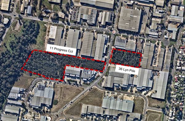
Figure 1 – Aerial Map of
Subject Sites (Near Map)
These two vegetated sites have high ecological
significance and have been encumbered by an existing Section 88B instrument
under the Conveyancing Act 1919 that does not permit development on the land.
Planning Proposal
The planning proposal (also known as Liverpool Local
Environmental Plan Draft Amendment 71) proposes changes to the planning
controls as listed in Table 1.
Table 1 – Current and proposed
controls for the subject sites.
|
Control
|
Current
|
Proposed
|
|
Zoning (LZN)
|
IN3 Heavy Industrial
|
E2 Environmental Conservation
|
|
Maximum height of building (HOB)
|
30m
|
N/A
|
|
Minimum lot size (LSZ)
|
2000m2
|
N/A
|
The rationale behind Amendment 71 is to provide
protection for sites that contain endangered ecological communities and
threatened species, in particular Acacia pubescens. Furthermore, the two
sites are both burdened by Section 88B instruments under the Conveyancing
Act 1919 that require:
· For Lot 10 DP 1003837, the permanent
protection and management of the site through a conservation management plan
and that any development of the site is prohibited; and
· For Lot 11 DP 1228445, no alteration of
native vegetation and the land to be retained as bushland and managed through a
management plan.
The rezoning of this land will ensure consistency
between the restriction on title, and the land use planning controls. There is
no actual loss of employment land as development on the subject sites is not
permitted due to the respective restrictions on title through the s88B
Instruments.
Despite the s88B Instruments applying to the site,
development applications (DAs) have been lodged with the intention of removing
the vegetation on 36 Lyn Parade (DA-1250/2016) and Lot 11 Progress Circuit (DA-
734/2018). The refusal, or deemed refusal of the respective DAs by Council,
resulted in Land and Environment Court proceedings which are detailed within
this report. The Court has issued judgments for both application by refusing
the applications.
The rezoning will not only provide greater legislative
protection for the high ecological value of the two sites, but also reduces
uncertainty that may result from the misalignment of the s88B instruments and
zoning.
Gateway determination
DPIE issued a Gateway Determination on 7 May 2018 (Attachment
4). The Gateway conditions required Council to undertake a number of
actions, including:
· Publically exhibit the proposal and
relevant documentation for a minimum of 28 days; and
· Provide a minimum of 21 days to the
following public authorities to comment on the proposal:
o NSW Office of Environment and Heritage;
o NSW Office of Environment and Heritage
– Heritage Division;
o NSW Rural Fire Service;
o NSW Department of Industry; and
o Australian Department of the Environment
and Energy.
The Gateway determination also authorised Council as
the local plan-making authority to make LLEP Amendment 71.
On 1 November 2018, DPIE altered the Gateway
Determination to require the inclusion of “a savings provision to
ensure that the proposed amendments do not affect any development applications
or appeal processes”. The planning proposal was amended to reflect
this change (Attachment 5). The purpose of this amendment is to ‘save’
any development approvals that may be granted by the Land and Environment
Court stemming from the legal proceedings in relation to the DA at Lot 11
Progress Circuit. As Council deferred consideration of this planning proposal,
until after the Court issued judgments on these appeals, and the fact the Court
has refused both DAs, this Clause may no longer be required. This will be
confirmed by DPIE during finalisation of the amendment.
Public authority consultation
In accordance with the Gateway determination, a copy
of the relevant documentation was forwarded to the specified public authorities
for comment from 10 May 2018 to 8 June 2018. Summaries of each submission and
the officer response are listed in Table 2 and original copies are included in Attachment
6. No changes are required as a result of public authority consultation.
Table 2 – Public authority
submissions and officer response.
|
Public authority
|
Summary of submission
|
Officer comments
|
|
NSW Office of Environment and Heritage
|
Support for the planning proposal and
the additional environmental protection for the endangered ecological
communities and threatened species on the site.
|
No response required.
|
|
NSW Office of Environment and Heritage –
Heritage Division
|
Noted. No objections raised.
|
No response required.
|
|
NSW Rural Fire Service (RFS)
|
Noted. No objections raised.
|
The planning proposal seeks
to rezone bushfire prone land. In accordance with Section 9.1 Ministerial
Direction 4.4 Planning for Bushfire Protection, Council must obtain
written advice from the RFS that notwithstanding any non-compliance with the
direction, the RFS does not object to the progression of the planning
proposal. The letter indicating the RFS has no objection provides this
written advice.
|
|
NSW Department of Industry
|
No comments received.
|
No response required.
|
Community consultation
In accordance with the Gateway
determination, the planning proposal and relevant documents were placed on
public exhibition from 23 May 2018 to 20 June 2018. Notices were placed on
Council’s website and the Liverpool Leader and letters were sent to the
two affected landowners and neighbouring landowners and occupiers. Four
submissions were received, two in support and two in objection. The two
objections were from the landowners of the respective sites. Summaries of each
submission and the officer response are listed in Table 3 and original copies
are included in Attachment 7. An independent peer review of one of the
objections was also undertaken (Attachment 8). No changes are proposed
as a result of community consultation.
Table 3 – Community submissions
and officer response (O: Objection, S: Support)
|
No.
|
Summary of submission
|
Officer comments
|
|
O1
|
Financial burden of owning the property and unable
to sell land despite no benefit to landowner
|
The subject site was an ecological offset site as
part of the previous industrial subdivision of the parent lot. The original
development consent required the concurrence of the National Parks and
Wildlife Service in order for the subdivision application to be approved. As
a result, 4.4ha of native vegetation was protected and its ongoing protection
was secured by an s88B Instrument.
|
|
Requests Council to purchase property
|
Council is under no obligation to purchase the site
and the landowner is required under the s88B Instrument to maintain the site.
|
|
S1
|
Support for the preservation of the endangered Acacia
Pubescens
|
Support noted.
|
|
Potential for the sites to be educational
demonstration areas and viable seedbank for future regeneration work throughout
the LGA
|
|
S2
|
Support for the protection of the last piece of
native bushland between Brickmakers and Cabramatta Creeks providing corridor
of habitat for fauna and flora including endangered Acacia Pubescens.
|
Support noted.
|
|
O2
|
Site purchased for the express purpose of developing
site for industrial purposes.
|
The subject site was offset as part of the
industrial subdivision. The s88B Instrument was signed by the current
landowner and they have already commercially benefited from the clearing of
native vegetation for industrial development.
|
|
Outline of a hypothetical industrial development
scenario which would achieve commercial viability
|
|
A Species Impact Statement (SIS) has been submitted
to support the proposed development scenario.
|
The submitted SIS was independently peer reviewed by
a SIS consultant engaged by Council. The review found that the submitted SIS
fails to comply with several Office of Environment and Heritage (OEH) Chief
Executive’s Requirements (CER). It was also found that the SIS makes no
reference to the site history or any details of the existing s88B
covenant.
Based on the result of the peer review, the SIS
provides insufficient information to substantiate the argument that the
proposed rezoning of the subject land to E2 — Environmental
Conservation should not go ahead.
|
|
If no development occurs, the vegetation will
degrade.
|
The s88B instrument, to which the landowner is a
signatory, requires the landowner to manage and retain the vegetation in
accordance with the Vegetation Management Plan. Should vegetation degradation
occur, this is a violation of the underlying development consent and s88B
instrument and enforcement action can be taken.
|
Court Proceedings
Since the deferral of this matter by Council in
December 2018, the NSW Land and Environment Court (LEC) proceedings have now
been finalised. The following provides a summary of the court proceedings on
both sites.
· Timpag Investments Pty Limited v Liverpool
City Council [2018] NSWLEC 1296 – This court case applied to 36 Lyn Parade and was a Class 1
appeal against Council’s refusal of DA-1250/2016. This DA sought consent
for the clearing of vegetation, site levelling and earth works for a warehouse.
The judgement of the LEC dismissed the appeal and upheld the refusal on 20 June
2018. This judgement is provided at Attachment 9.
· Denoci Pty Limited v Liverpool City Council
[2019] NSWLEC 1643 –
This Court case was active when Council deferred its consideration of the
post-exhibition Council report in December 2018 in relation to 11 Progress
Circuit. The Court issued its judgement on 24 December 2019. This was a Class 1
appeal against Council’s deemed refusal of DA-734/2018. This DA sought
consent for site earthworks and the removal of vegetation to accommodate a
future footprint for two warehouse buildings. The Commissioner of the Court
dismissed the appeal and determined by refusal the DA on 24 December 2019. This
judgement is provided at Attachment 10.
· Denoci Pty Ltd v Liverpool City Council
[2020] NSWLEC 102 –
Following the judgement that refused DA-734/2018, the applicant appealed this
decision from the Commissioner of the Court and sought a final decision from a
Judge at the LEC. Justice Brian J Preston dismissed this appeal from the
applicant in his decision on 30 July 2020. This judgement is provided at Attachment
11.
Alterations to Gateway determination
Given the numerous court cases and subsequent delays
in finalising the planning proposal, the Department of Planning, Industry and
Environment (DPIE) issued a number of Gateway alterations to extend the
timeframe for finalising Amendment 71. Below is summary of these Gateway
alterations since the post-exhibition report was considered by Council in
December 2018:
· Extension until 6 December 2019 –
Granted on 5 June 2019;
· Extension until 6 May 2020 – Granted
on 15 December 2019 ; and
· Extension until 6 November 2020 –
Granted on 7 July 2020.
These Gateway alterations are compiled with the
original Gateway determination (Attachment 4).
Conclusion
The Gateway requirements, including
consultation for Draft Amendment 71 have been satisfied, submissions received
have been addressed and the planning proposal has been updated as required by
the gateway determination. Council deferred the post-exhibition report due to
the court proceedings underway at the 12 December 2018 Council meeting. Since
this Council decision, the Court has finalised all appeals relating to the
subject sites and confirmed the refusal of each DA. Therefore, Council can now
proceed to finalise this planning proposal.
This report recommends that Council
proceeds with Amendment 71 and liaises with the Parliamentary Counsel’s
Office and DPIE for the amendment to be gazetted.
|
Economic
|
There are no economic and financial considerations.
|
|
Environment
|
Protect, enhance and maintain areas of endangered ecological
communities and high-quality bushland as part of an attractive mix of land
uses.
|
Social
|
There are no social and cultural considerations.
|
Civic Leadership
|
Act as an environmental leader in the community.
Undertake communication practices with the community and stakeholders
across a range of media.
Operate a well-developed governance system that demonstrates
accountability, transparency and ethical conduct.
|
|
Legislative
|
Environmental Planning and Assessment Act 1979
Conveyancing Act 1919
|
|
Risk
|
The risk is considered to be Low.
The risk is considered within
Council’s risk appetite.
|
1. Post-exhibition
Council report - 12 December 2018 (Under separate cover)
2. Council
Resolution - 12 December 2018 (Under separate cover)
3. Council
Resolution - 7 February 2018 (Under separate cover)
4. Gateway
determination and alterations (Under separate cover)
5. Planning
Proposal LLEP 2008 Amendment 71 (Under separate cover)
6. Public
Authority Submissions (Under separate cover)
7. Community
Submissions (Under separate cover) - Confidential
8. Independent
Peer Review of Species Impact Assessment (Under separate
cover)
9. Judgement
of Land & Environment Court – Refusal of DA-1250/2016 at 36 Lyn
Parade, Prestons (Under separate cover)
10. Judgement
of Land & Environment Court – Refusal of DA-734/2018 at 11 Progress
Circuit, Prestons
(Under separate cover)
11. Judgement
of Land & Environment Court – Upheld Refusal of DA-734/2018 at 11
Progress Circuit, Prestons (Under separate cover)
Ordinary Meeting
26 August 2020
City Economy and Growth Report
|
EGROW 04
|
Status update on planning proposal
requests in Moorebank
|
|
Strategic
Direction
|
Strengthening
and Protecting our Environment
Exercise
planning controls to create high-quality, inclusive urban environments
|
|
File Ref
|
204535.2020
|
|
Report By
|
Luke Oste -
Executive Planner
|
|
Approved
By
|
David Smith
- Acting Director City Economy and Growth
|
At Council’s ordinary meeting on 29 July 2020,
Council considered item EGROW 03
concerning a planning proposal request to rezone land from RE2
(Private Recreation) to R3 (Medium Density Residential) at 146 Newbridge Road,
Moorebank (Attachment 1).
In
addition to adopting the recommendations relating to the planning proposal
request, it was resolved that Council:
Receive a further report with a status update on all the
outstanding planning proposals from Moorebank at the August 2020 Council
meeting.
This report has been prepared to provide a status
update on all outstanding planning proposals within Moorebank in accordance
with this resolution. A description of and status update for the following
planning proposal requests is provided:
· LEP Review Phase 1 (RZ-14/2015) relating to
the Moorebank Town Centre R4 zoning;
· Moore Point (RZ-6/2015) – Joint
Owners Group Proposal (JOP) – Coronation Property and Lemac Property
Group;
· Moore Point (RZ-4/2018) – Rose Group
/ Fortis;
· Site A Moorebank East (RZ-9/2017) –
‘Georges Cove Village’;
· Site B Moorebank East (RZ-4/2017) –
‘Flower Power’;
· Site C Moorebank East (RZ-1/2019) –
‘Georges Cove’;
· Site D Moorebank East (RZ-5/2018) –
‘Georges Cove Marina’; and
· Site E Moorebank East (RZ-2/2020) –
Lot 6 Newbridge Road.
A status update of all planning proposal requests, and
other strategic planning projects is also provided to Councillors quarterly at
the Strategic Panel meeting.
|
That Council receives and notes this report.
|
Background
At Council’s ordinary meeting on 29 July 2020,
Council considered a planning proposal
request to rezone land from RE2 (Private Recreation) to R3 (Medium Density
Residential) at 146 Newbridge Road, Moorebank. Council supported this planning
proposal request (RZ-1/2019) proceeded to a Gateway determination. In addition
to adopting the recommendations relating to the planning proposal request,
Council also resolved that Council:
Receive a further report with a status update on all
the outstanding planning proposals from Moorebank at the August 2020 Council
meeting.
This report has been prepared to provide a status
update on all outstanding planning proposals within Moorebank in accordance
with this resolution.
LEP Review Phase 1 – Moorebank Town Centre
Component
A planning proposal for the LEP Review Phase 1
involves numerous changes to the LEP applying across the Liverpool Local
Government Area (LGA). Of relevance to this report are changes proposed to the
LEP in Moorebank to rezone portions of the existing R4 (High Density
Residential) zone to R3 (Medium Density Residential) along with associated
amendments to development standards. Public consultation on this planning
proposal occurred from 10 June to 21 July 2020.
The LEP Review Phase 1 Post Exhibition report is on
the Agenda for this Council meeting. The funding agreement for the LEP review
requires Council to finalise this planning proposal and to submit it to the
Department of Planning, Industry & Environment (DPIE) for gazettal by 31
August 2020.
Moore Point
The Moore Point precinct (otherwise known as Georges
River North) refers to a number of sites totaling 38.5 hectares direct to the
east of the Liverpool City Centre bounded by the Georges River, Newbridge Road,
Haigh Park, Lake Moore and McMillan Park. The precinct is currently zoned IN2
(Light Industrial).
This precinct is identified in Council’s Local
Strategic Planning Statement (LSPS) as a future urban renewal area and states
that Council will ‘investigate residential/mixed use at Moore Point to
support the CBD and Innovation Precinct’. The timeframe provided in the
LSPS to progress planning is in the short-medium term (2020-2025).
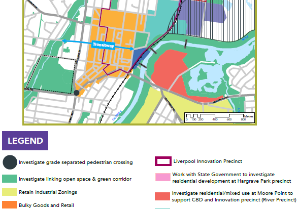
Figure 1 –Precinct
location (LSPS, Connected Liverpool 2040)
The precinct has been subject to numerous planning
proposals over the past five years. To appropriately manage future planning for
this area, Council advised the major landholders in the area that a precinct
wide approach to planning was necessary, supported by a comprehensive urban
design study and structure plan to guide development.
Joint Landowner Group Proposal – RZ-6/2015
The applicants planning proposal
justification report is provided at Attachment 2. A joint landowner group, comprising Leamac
Property Group and Coronation Property, which collectively owns the majority
(32 hectares;~83%) of the Moore Point precinct, submitted a revised planning
proposal request for their landholdings on 15 April 2020, which was accompanied
by an Urban Design Study, including illustrative master plan, for the entire
precinct to guide future planning and development.

Figure 2 – Precinct boundary
and land ownership. The land indicated in yellow and blue is subject to
RZ-5/2016 Planning Proposal (SJB Urban).
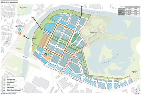
Figure 3 – Moore Point
illustrative master plan
The revised planning proposal request submitted by the
JLG replaces previous planning proposal RZ-6/2015 and the JLG also withdrew all
other previous site-specific proposals lodged by the proponents.
The revised planning proposal request seeks the
following amendments to the Liverpool Local Environmental Plan 2008:
· Rezone the site from IN2 (Light Industrial)
to B4 (Mixed Use) and B6 (Enterprise Corridor);
· Increase the maximum floor space ratio to
4.2:1 and 3.5:1;
· Increase the maximum height of buildings
from 18m and 15m to RL 136 and RL 108; and
· Introduce Division 1A into the LEP to
provide site specific development controls for the site including design
excellence, sun access controls, and requirements for preparation of a
site-specific development control plan.
In its entirety, the illustrative master plan for the
precinct would allow for 1,256,559m2 of residential GFA, equating to
around 14,783 dwellings, and 344,499m2 of mixed-use employment floor
space. Owing to the large scale of the planning proposal request it is expected
that development would be staged over a 30-40-year period.
Council has established three collaborative working
groups with the Joint Landowner Group, State Government stakeholders (including
Greater Sydney Commission, Transport for NSW and DPIE) and relevant consultants
to resolve planning and transport issues. The working groups, which meet
monthly, include:
· A transport infrastructure working group,
to oversee strategic transport modelling being conducted for the entire
Liverpool Collaboration Area. The group involves representatives from Council,
the JLG, Transport for NSW, DPIE, the Greater Sydney Commission, and
consultants;
· A placemaking working group, to collaboratively assess place-led opportunities to ensure the precinct
vision is delivered based on world’s best practice. The group involves
representatives from Council, the JLG and independent advisors to Council and
the JLG; and
· A statutory planning working group, to
resolve planning issues associated with the planning proposal prior to sending
the proposal to the Local Planning Panel, Council for consideration and DPIE
for a Gateway review. The group includes representatives from Council, the JLG,
and independent advisors to the JLG.
As well as working through issues as part of the
working groups, from April-July 2020 Council staff conducted extensive internal
consultation on the planning proposal request. This informed a ‘Request
for Information’ letter that was provided to the proponents on 3 August
2020. The proponents are currently responding to the issues raised during
Council’s assessment.
The planning proposal request timeline since lodgment
is summarised in Table 1 below:
Table 1 –
Moore Point (RZ-6/2015) timeline
|
Timeline
|
|
Date
|
Milestone/Event
|
|
05/06/2015
|
Original planning proposal request lodged with
Council.
|
|
14/12/2016
|
Council resolved to defer consideration
of the planning proposal request in order to enter into a collaborative
working relationship with the proponent to determine the appropriate controls,
including height and FSR, to apply to the precinct.
|
|
14/04/2020
|
Proponents present their vision for the site to
Councillors at the Strategic Panel meeting.
|
|
15/04/2020
|
Council receives an amended planning
proposal request covering 32 ha of the Moore Point area, with other planning
proposals on the subject land withdrawn.
|
|
24/04/2020
|
Internal referrals commenced
|
|
03/08/2020
|
Assessment of proposal completed and
request for additional information letter sent to proponent
|
In accordance with Council’s
resolution of 29 July 2020 and the requirements of the Liverpool Community
Participation Plan (CPP), the planning proposal request is currently on public
exhibition for 28 days.
Council is awaiting additional
information that was requested to complete the assessment of the planning
proposal request. Following completion of the assessment, advice will be sought
from the LPP and then a report will be prepared for Council’s
consideration.
Rose Group/Fortis (RZ-4/2018) – 335-349
Newbridge Road
Council has received a second planning proposal
request in the Moore Point precinct, covering two lots at 335-349 Newbridge
Road. The proposal was received on 19 June 2019 and replaces an earlier
proposal received on 13 June 2018, following acquisition of an additional lot. The applicants planning
proposal justification report is provided at Attachment 3.
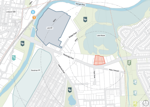
Figure 4 – Subject
site in red
The planning proposal request seeks the following
amendments to the Liverpool Local Environmental Plan 2008:
· Rezone the site from IN2 (Light Industrial)
to B4 (Mixed Use);
· Adopt a non-residential floor space ratio
of 0.4:1;
· Increase the maximum floor space ratio to
3.2:1; and
· Increase the maximum height of buildings to
60m.
The proposal seeks to provide approximately 45,650m2
of GFA that would account for a total of 536 dwellings, and 6,300m of
commercial floorspace on a total site area of 16,207m2.
This planning proposal request is currently under
assessment and Council has engaged with the proponent on the structure planning
work undertaken by the JLG and is currently undertaking internal consultation
on the proposal.
The planning proposal timeline since lodgment is
summarised in Table 2 below:
Table 2 –
Rose Group/Fortis (RZ-4/2018) timeline
|
Timeline
|
|
Date
|
Milestone/Event
|
|
13/06/2018
|
Initial planning proposal request lodged for 337-349
Newbridge Road received by Council.
|
|
19/06/2019
|
Updated planning proposal request
received following acquisition of adjoining property 335 Newbridge Road.
|
|
14/07/2020
|
Council meets with proponents to discuss planning
proposal request and Urban Design Study developed for the precinct by JLG
proponents
|
|
07/08/2020
|
Council receives formal feedback on
Urban Design Study from the proponents
|
|
10/08/2020
|
Internal referrals
|
In accordance with Council’s
resolution of 29 July 2020 and the requirements of the Liverpool Community
Participation Plan (CPP), the planning proposal request is currently on public
exhibition for 28 days and is under assessment.
Following completion of the
assessment, advice will be sought from the LPP and then a report will be
prepared for Councils consideration.
Moorebank East Precinct – Site and Locality
Description
The Moorebank East Precinct is a collection of sites
that are largely undeveloped located along the western bank of the Georges
River on the eastern border of the Liverpool LGA. The precinct is bounded by
the following:
· North – Newbridge Road initially, and then the
Chipping Norton industrial estate. To the north-west is the Chipping Norton
residential area. To the north-east is a significant expanse of green space
including Riverside Park.
· South – Brighton Lakes Golf Club initially, and then
the M5 South-West motorway. To the south-west is the Brighton Lakes residential
development.
· East – The site is bound by the Georges River, with
the Canterbury Bankstown LGA on the east side of the river. To the north-east
is the Davy Robinson Park and Boat Ramp, as well as some residential
development that is covered by the Moorebank Voluntary Acquisition Scheme.
Milperra is located on the east side of the river, with significant open and
green space located in proximity to the precinct.
· West – Wurrungwuri Reserve initially and then
Brickmakers Drive. To the west of Brickmakers Drive is the Georges Fair
residential area and Moorebank Town Centre approximately 1km west from the
subject precinct.
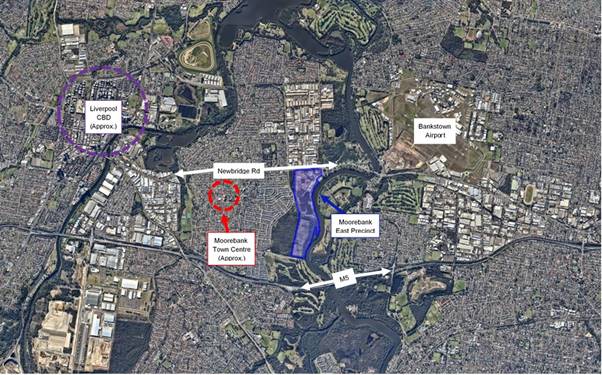
Figure 5 – Context Map
of the Subject Precinct (Source: Near Map)
The precinct has been divided into
five distinct sites in accordance with the varying developments being proposed
as part of both planning proposal requests and development applications (DA’s).
For simplicity, each distinct site within the precinct is identified this way
within this report and planning documentation. These are visually represented
in Figure 6 below.
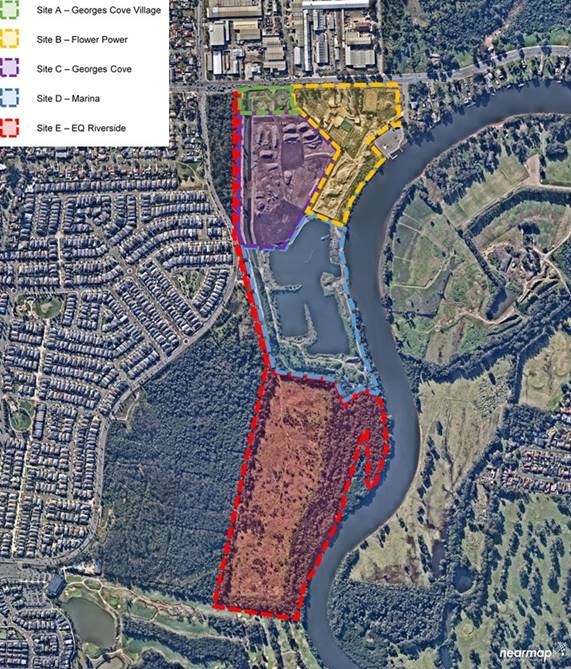
Figure 6 –
Aerial Map of the Subject Precinct and Sites A – E (Source: Near Map)
Moorebank East Precinct – Structure Plan
Given the number of planning
proposal requests in this area and the resulting complexity of the scale of
development proposed, Tract Consultants were engaged by Council to prepare a
high-level strategic plan to guide planning within the precinct.
Following collaboration between
Tract Consultants and the proponents for each site, a structure plan was
prepared as is illustrated in Figure 7 below. It should be noted that Site E
was not included in the structure plan as no planning proposal had been lodged
at the time this plan was prepared.
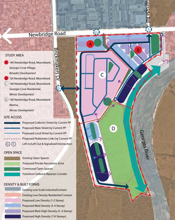
Figure 7 –
Draft Structure Plan Moorebank East (Source: Tract Consultants)
A site description, proposal
summary, and timeline is provided for each planning proposal request within the
subject precinct below.
Site A (RZ-9/2017) –
Georges Cove Village
The applicants planning proposal
justification report is provided at Attachment 4.
Site A is located within the broader
146 Newbridge Road lot which is legally described as Lot 7 DP 1065574. This
site is an irregular shaped allotment that is approximately 10,700m2
in size. The site adjoins Newbridge Road to the north and has been used for
extractive and recycling operations since a development consent was issued in
1992. The site currently contains some stockpiled soils and construction
materials.
The planning proposal request
originally submitted sought to enable:
· 97
seniors housing apartments;
· 65
dwellings;
· 9
serviced apartments; and
· Neighbourhood
retail and commercial facilities including a childcare centre, medical centre,
grocery shops and a gym.
Following the preparation of the
Moorebank East Structure Plan, a revised planning proposal request was
submitted which now seeks to enable:
· 126
dwellings;
· Medical
centre; and
· 4,200m2
retail floorspace.
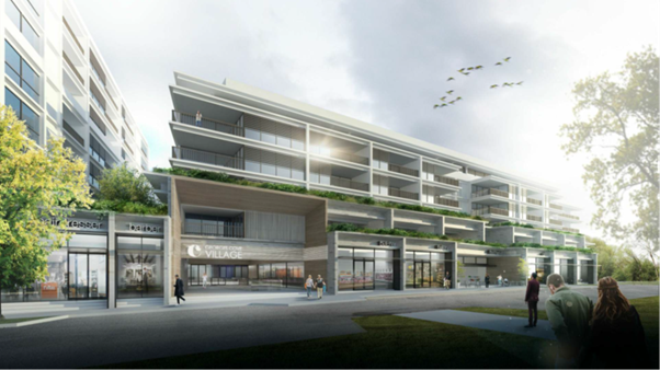
Figure 8 – Site A (Georges
Cove Village) Concept Design Extract (Source: Rothelowman)
The proposed amendments to the LEP
include:
· Increasing
the height of buildings development standard (HOB) from a maximum of 15m to
25m;
· Increasing
the floor space ratio (FSR) development standard from a maximum of 0.75:1 to
1.2:1; and
· Including
a Schedule 1 amendment to permit ‘health care facility’ (medical
centre) and 4,200m2 of retail.
The timeline of the planning
proposal request since lodgment is summarised in Table 3:
Table 3 –
Site A (RZ-9/2017) timeline
|
Timeline
|
|
Date
|
Milestone/Event
|
|
18/10/17
|
Planning proposal request lodged and received by
Council.
|
|
02/11/17
|
Letter received from NSW State Emergency
Services (SES) with concerns surrounding flooding and evacuation for Site D
(Marina proposal) within the site.
|
|
18/01/18
|
Internal referrals
|
|
11/01/18
|
Tract Consultants engaged to provide a
merit assessment of the Site A and Site B planning proposals and to prepare a
precinct wide structure plan
|
|
19/04/18
|
First iteration of Tract Consultants’
assessment report for Site A received.
|
|
26/06/18
|
Second iteration of Tract
Consultants’ assessment report for Site A and draft structure plan
received.
|
|
16/07/18
|
Meeting with proponent, Tract Consultants and
Council staff to discuss issues with the proposal and to discuss the draft
structure plan.
|
|
06/08/18
|
Proponent response letter sent to Tract
Consultants and Council staff.
|
|
Aug – Dec 2018
|
Waiting for other landowners within the precinct to
respond with comments on the draft Structure Plan and its impact on their
sites.
|
|
07/12/18
|
Tract Consultants response to proponents
regarding the planning proposal requests and draft Structure Plan.
|
|
19/12/18
|
Meeting with proponents regarding progression of
structure plan and their planning proposal request.
|
|
Jan – Apr 2019
|
Ongoing discussion between the applicant
and Council staff regarding a revised proposal.
|
|
24/05/19
|
Meeting between Council staff, Office of Environment
and Heritage (OEH) and SES regarding flooding concerns
|
|
27/05/19
|
Revised planning proposal request
submitted by the applicant with supporting documentation.
|
|
04/06/2019
|
Email sent to the applicant outlining the outcomes
of the meeting with OEH and SES, including the need for a comprehensive flood
emergency risk assessment for the precinct.
|
|
13/08/19
|
Inception meeting held with the flood
consultant (Molino Stewart), Council staff, and the applicants.
|
|
12/11/19
|
Molino Stewart comprehensive flood emergency risk
assessment finalised.
|
|
27/02/20
|
Response provided by the applicant to
Council staff offering solutions to the issues identified in the
comprehensive flood emergency risk assessment.
|
|
09/03/20
|
Internal referrals for the revised planning proposal
request and documentation submitted by the applicant.
|
|
27/03/20
|
Clarification provided by Molino Stewart
regarding the flood evacuation of Sites A, C and D.
|
|
21/05/20
|
Tract Consultants provide a report for the Local
Planning Panel’s advice for Site A.
|
|
29/06/20
|
LPP considers the Site A planning
proposal request and provided their advice.
|
In accordance with Council’s
resolution and the Community Participation Plan (CPP), the planning proposal
request is currently on public exhibition for 28 days. A report will be
prepared for Council that includes an assessment of the proposal, responses to
the LPP advice, and an outline of the community feedback received during the
exhibition period.
Site B (RZ-4/2017) – ‘Flower
Power’
The applicants planning proposal
justification report is provided at Attachment 5.
Site B is located at 124 Newbridge Road and is
legally described as Lot 2 DP 602988. The site is an irregular shaped
allotment that is approximately 70,430m2. The site adjoins Newbridge
Road to the north and Davy Robinson Reserve to the east. In October 2012,
Liverpool City Council approved DA-309/2011 for earthworks and filling of the
site in two stages, to raise the subject site to mitigate flooding impacts.
Stage 1 is currently being implemented, while Stage 2 applies to the Flower
Power occupied portion of the site and has not yet begun.
The planning proposal request
originally submitted sought to enable:
· 757
apartments;
· 188
serviced apartments; and
· 25,255m2
of commercial gross floor area (including serviced apartments);
Following the preparation of the
Moorebank East Structure Plan, an addendum to the Urban Design Report was
submitted with a slightly revised proposal to enable:
· 602
apartments;
· 167
serviced apartments; and
· 22,434m2
of commercial gross floor area (including serviced apartments).
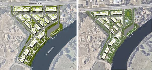
Figure 9 –
Concept Design for Site B (Original on the left and revised on the right)
(Source: AE Design Partnership)
The proposed amendments to the LEP
include:
· Rezoning the
current RE1 Public Recreation, RE2 Private Recreation and B6 Enterprise
Corridor to:
o B6 Enterprise
Corridor in the northern portion of the site;
o R3 Medium
Density Residential for the central portion of the site; and
o RE1 Public
Recreation along the river and Davy Robinson Reserve.
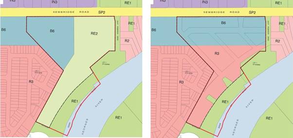
Figure 10
– Proposed rezoning of Site A (RZ-4/2017) – ‘Flower
Power’ (Source: SG Haddad Advisory and FGCS)
In addition to the proposed
rezoning, the following amendments are proposed to the LEP:
· Increase the maximum HOB in the
B6 Enterprise Corridor from 15m to 24m;
· Increase the maximum HOB from
15m to 30m for the remainder of the site;
· Increase the maximum FSR in the
B6 Enterprise Corridor from 0.75:1 to 1.5:1;
· Increase the maximum FSR for
the remainder of the site from 0.25:1 to 1.5:1; and
· Amend
Schedule 1 to permit residential flat buildings on the site.
It is noted that the revised concept
design was submitted by the applicant as an addendum to the Urban Design Report
originally submitted. This revised design offered a redistribution of density
(FSR) and height across the site. However, no specific changes were made to the
planning proposal request.
The timeline of the planning
proposal request since lodgment is summarised in Table 4:
Table 4 –
Site B (RZ-4/2017) timeline
|
Timeline
|
|
Date
|
Milestone/Event
|
|
07/06/17
|
Planning proposal request was lodged and received by
Council.
|
|
26/07/17
|
Internal referrals
|
|
08/08/17
|
Internal stakeholder meeting
|
|
02/11/17
|
Email sent to the applicant outlining
the various issues and inconsistencies with the proposal.
|
|
11/01/18
|
Tract Consultants engaged to provide a merit
assessment of the Site A and Site B planning proposals and to prepare a
precinct wide structure plan
|
|
15/02/18
|
Updated stormwater plans requested from
the proponent.
|
|
01/03/18
|
Stormwater plans provided to Council staff and Tract
Consultants.
|
|
21/03/18
|
Workshop between Council staff and Tract
Consultants
|
|
19/04/18
|
Draft planning proposal assessment and draft
structure plan provided by Tract Consultants to Council staff.
|
|
26/06/18
|
Revised draft planning proposal
assessment and draft structure plan provided by Tract Consultants to Council
staff.
|
|
18/07/18
|
Meeting held with the applicant regarding the draft
structure plan prepared by Tract Consultants.
|
|
28/08/18
|
Written response to the draft structure
plan provided by the applicant including an addendum to the Urban Design
Report. The revised design included the redistribution of density and height
across the site and additional open space provision. This resulted in a
reduction in the number of proposed serviced apartments from 188 to 154 and apartments
757 to 589.
|
|
15/01/19
|
Meeting between the applicant, Council Staff and
Tract Consultants to discuss the Site B revised design and the progress of
the structure plan.
|
|
11/02/19
|
The following was received from Tract
Consultants:
· Updated draft planning
proposal assessment received for Site A and Site B.
· Updated structure plan
received incorporating the changes negotiated with the applicants for Site A
and Site B.
· Draft DCP Amendment (Part
2.10 Development in Moorebank East).
|
|
22/03/19
|
Holistic Traffic Assessment received from the
applicants for Site A-D.
|
|
24/05/19
|
Meeting between Council staff, Office of
Environment and Heritage (OEH) and SES regarding flooding concerns
|
|
12/06/2019
|
Email sent to the applicant outlining the outcomes
of the meeting with OEH and SES, including the need for a comprehensive flood
emergency risk assessment for the precinct.
|
|
13/08/19
|
Inception meeting held with the flood
consultant (Molino Stewart), Council staff, and the applicants.
|
|
12/11/19
|
Molino Stewart comprehensive flood emergency risk
assessment finalised.
|
|
12/11/19
|
Email sent to the applicant providing
the Molino Stewart comprehensive flood emergency risk assessment and
outlining the issues needing to be resolved in order for the planning
proposal to progress.
|
In accordance with Council’s
resolution and the Community Participation Plan (CPP), the planning proposal
request is currently on public exhibition for 28 days.
Council is awaiting a response from
the applicant and a revised planning proposal request that addresses the
Moorebank East Structure Plan and Molino Stewart comprehensive flood emergency
risk assessment. Once this is received, Tract Consultants can compete their
assessment and advice can be sought from the LPP and a report prepared for
Council’s consideration.
Site C (RZ-1/2019)
This planning proposal request was considered by Council at the 29 July
2020 Council meeting. At this meeting Council resolved:
That Council
1. Notes the advice of the Liverpool Local Planning
Panel;
2. Endorses in principle the planning proposal
request;
3. Delegates to the CEO to prepare the formal
planning proposal including any typographical or other editing amendments if
required;
4. Forwards the planning proposal to the Department
of Planning, Industry and Environment, pursuant to Section 3.34 of the
Environmental Planning and Assessment Act 1979, seeking a Gateway
determination;
5. Subject to Gateway determination, undertake
public exhibition and community consultation on the planning proposal in accordance
with the conditions of the Gateway determination and Council’s Community
Participation Plan;
6. Receive a further report on the outcomes of
public exhibition and community consultation;
7. Receive a further report with a status update on
all the outstanding planning proposals from Moorebank at the August 2020
Council meeting; and
8. Publicly exhibit all of the outstanding planning
proposals in Moorebank now.
Council has forwarded the planning
proposal to the Department of Planning, Industry, and Environment (DPIE) and is
awaiting a Gateway determination.
Site D (RZ-5/2018) –
‘Georges Cove Marina’
The applicants planning proposal
justification report is provided at Attachment 6. Site D is
located in the southern portion of 146 Newbridge Road, Moorebank, legally
described as Lot 7 in DP 1065574. The specific area of application for this
planning proposal request is illustrated in Figure 11 below.
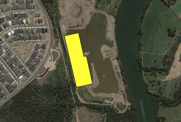
Figure 11 – Area of application
for Site D (RZ-5/2018) planning proposal (Source: Square Link Pty Ltd)
Following the Land and Environment Court granted consent for the
extraction of sand in 1993, the site has had extractive industries activity
occur via dredging and dry extraction methods. The site’s former
extractive industries use has reached the end of its economic life and various
proposals has been proposed for a marina development.
This specific marina portion of the 146 Newbridge Road site has had a
long and complicated history that has involved numerous court cases involving
both DA’s and a planning proposal (RZ-2/2015). This previous planning
proposal was supported by Council at its meeting on 31 August 2016 and
subsequently received a Gateway determination. However, this Gateway determination
was declared invalid by the Court of Appeal – NSW Supreme Court in
December 2018. It is noted that the DA for the marina proposal (DA-611/2018) is
currently under assessment that includes:
· A maritime building which will house a dry berth
facility (250 berths), a function centre, tourist, entertainment, recreation
and club facilities, a petrol storage tank (60,000 litres) and a diesel storage
tank (60,000 litres).
· A wet berth facility for 186 craft (including casual
berths) which will consist of a marina basin, rock protection of the basin and
foreshore, including embellishment and revegetation of the river foreshore,
construction of a navigation channel, construction of public recreational
facilities on the foreshore, floating berths and walkways, fuel pumping
facilities, sewage pump out facilities and emergency berth access.
· Construction of three external car parking areas and
basement car park providing a total of 637 car spaces.
· A private marina clubhouse.
· Associated works and support infrastructure including
power, water and sewerage.
The current planning proposal (RZ-5/2018) for Site D seeks to facilitate
a residential development consisting of 353 apartments and 21 terrace
dwellings. It is noted that the previously supported planning proposal
(RZ-2/2015) proposed to facilitate 125 apartments.
The following amendments are proposed to the LEP:
· Schedule 1 amendment to permit residential accommodation;
· Increase HOB from current 21m to RL 38.9m ; and
· Increase FSR from current 0.25:1 to 0.4:1.
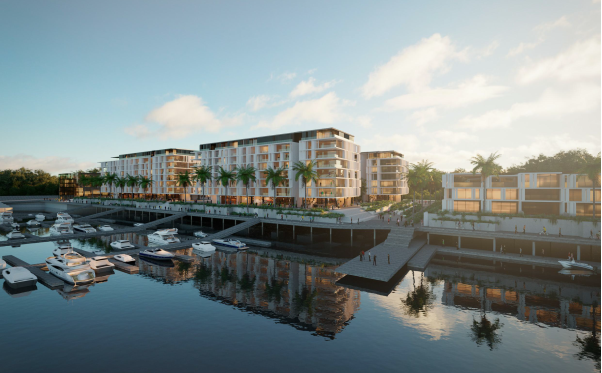
Figure 12 – Site D (Georges Cove Marina)
extract from Concept Design (Source: Mirvac)
The timeline of the planning
proposal since lodgment is summarised in Table 5:
Table 5 –
Site D (RZ-5/2018) timeline
|
Timeline
|
|
Date
|
Milestone/Event
|
|
06/07/18
|
Planning proposal was lodged and received by
Council.
|
|
14/08/18
|
Planning proposal was presented by the
applicant to Council’s Strategic Panel.
|
|
14/12/18
|
Court case determined for the previous planning
proposal (RZ-2/2015), resulting in the Gateway determination being declared
invalid.
|
|
18/01/19
|
Internal referrals
|
|
22/03/19
|
Holistic Traffic Assessment received from the
applicants for Site A-D.
|
|
16/04/19
|
Email sent to applicant outlining
flooding concerns raised from internal referrals and informing of a meeting
with OEH and SES.
|
|
01/05/19
|
Response provided by the applicant to
Council’s concerns regarding flooding.
|
|
09/05/19
|
OEH comments received for the planning
proposal and broader structure plan.
|
|
24/05/19
|
Meeting between Council staff, OEH and SES regarding
flooding concerns in the Precinct.
|
|
04/06/2019
|
Email sent to the applicant outlining
the meeting had with OEH and SES. The email also outlined the need for a
comprehensive flood emergency risk assessment for the precinct.
|
|
13/08/19
|
Inception meeting held with the flood consultant
(Molino Stewart), Council staff, and the applicants.
|
|
12/11/19
|
Molino Stewart comprehensive flood
emergency risk assessment finalised.
|
|
12/11/19
|
Email sent to the applicant providing the Molino
Stewart comprehensive flood emergency risk assessment and outlining the
issues needing to be resolved in order for the planning proposal to progress.
|
|
27/02/20
|
Response provided by the applicant to
Council staff offering solutions to the issues identified in the comprehensive
flood emergency risk assessment.
|
In accordance with Council’s
resolution and the Community Participation Plan (CPP), the planning proposal
request is currently on public exhibition for 28 days. Council is currently
finalising its assessment of the proposal and will be considered by the LPP
prior to report being prepared for Council’s consideration.
Site E (RZ-2/2020)
In 2018, the previous owner sold Lot 6
Newbridge Road.
At Council’s meeting on 30 May 2018,
Council resolved the following in relation to NOM 02:
That
Council:
1. In principle, support a proposal for a
residential (and auxiliary) land use on the site known as the Moorebank
Recyclers in lieu of a recycling facility;
2. Note that any proposal needs to undergo the standard
assessment process;
3. Work closely with the proponent to ensure the
best possible outcome for the site in a timely manner, should a proposal be
received; and
4. Organise
a community BBQ once and if the development approval for the recycling plant is
surrendered.
Site E is located at Lot 6 Newbridge
Road and is legally described as Lot 6 in DP 1065574. The site is currently
accessed via Newbridge Road to the north and
is bound by the Georges River to the east, Wurrungwuri Reserve to the west,
Site D (proposed Marina site) to the north and Brighton Lakes Golf Course to
the south. The site is currently zoned E2 (Environmental Conservation). Within
the site is a disused non-putrescible landfill which operated across the site
between 1972 and 1979. Along the sites borders and to the west within the
Wurrungwuri Reserve is good condition vegetation that includes threatened
ecological communities and some coastal wetlands along the banks of the river.
The Planning Assessment Commission (as it was
then known) issued a development consent on 11 September 2015 for a materials
recycling facility on the subject site. The Land and Environment Court
subsequently confirmed this approval on 14 July 2017 after Council appealed the
consent.
A planning proposal request (Attachment 7). was lodged on 5 March
2020 that sought to achieve the applicant’s vision, ‘to provide
a diverse, vibrant, active and accessible residential neighbourhood, bound by
the banks of the Georges River and surrounding river woodland, to create an
attractive place to live and play’. The proposal seeks to facilitate
the following development:
· 2,000
apartments;
· 800m2
of community facilities;
· 1,700m2
of retail, restaurant and associated uses;
· 730m of
foreshore walkway/activation waterfront, facilitating open space linkage to
adjoining residential and recreational sites; and
· A
series of ecological and recreational parks

Figure 13 – Site E (RZ-2/2020) extract
from Urban Design Report (Source: DEM)
To achieve this proposed development, the
planning proposal seeks to rezone:
· The
existing E2 (Environmental Conservation) land within Lot 6 Newbridge Rd to a
combination of R1 (General Residential) and RE1 (Public Recreation); and
· The
existing E2 (Environmental Conservation) land on land adjoining to the west to
SP2 (Infrastructure) to enable access to the site.
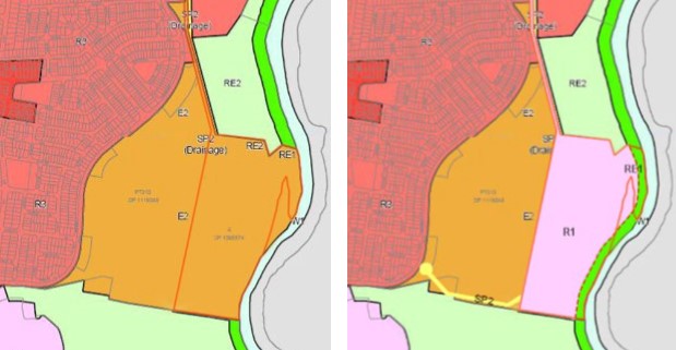
Figure 14
– Proposed rezoning of Site E (RZ-2/2020) – ‘Moorebank
recyclers’ (Source: SG Haddad Advisory and FGCS)
In addition to the proposed rezoning, the
following amendments to development standards within the LEP are proposed:
· Include
a maximum HOB control of 50m; and
· Increase
the maximum FSR control from 0.01:1 to 1:1.
The timeline of the planning
proposal request since this Council resolution is summarised in Table 6:
Table 6 –
Site E (RZ-2/2020) timeline
|
Timeline
|
|
Date
|
Milestone/Event
|
|
13/07/18
|
Meeting with proponent to discuss development of a
structure plan for the Moorebank East precinct
|
|
10/08/18
|
Meeting with proponent to discuss
density and height
|
|
20/02/19
|
Meeting to discuss planning positioning paper
prepared by the proponent. This document explained what the proponents were
considering for the site
|
|
25/02/19
|
Traffic Assessment provided by the
applicant to Council staff that assesses the cumulative impact of Sites A
– E.
|
|
01/04/19
|
Email sent to the proponent outlining Council
concerns regarding:
· Site access;
· Flooding and flood evacuation;
· Bushfire risk and evacuation; and
· Maximum height of buildings and the
Obstacle Limitation Surface (OLS) to Bankstown Airport.
|
|
11/04/19
|
Meeting with proponents to discuss their
concerns re timeframes with Director and Manager. Noting that no planning
proposal has been lodged.
|
|
22/07/19
|
Meeting held between the applicant and Council staff
to discuss the progression of lodgement of a planning proposal.
|
|
13/08/19
|
Inception meeting held with the flood
consultant (Molino Stewart), Council staff, and the applicants.
|
|
10/09/19
|
Flood evacuation report provided for Site E by the
applicant to Council staff and Molino Stewart.
|
|
20/09/19
|
Formal pre-planning proposal meeting
with the applicant and Council staff.
|
|
09/10/19
|
Detailed pre-planning proposal advice provided to
the applicant.
|
|
12/11/19
|
Molino Stewart comprehensive flood
emergency risk assessment finalised.
|
|
05/03/20
|
Planning Proposal request lodged and received by
Council.
|
|
03/06/20
|
Internal referrals
|
|
30/06/20
|
Letter detailing the outcomes of the initial
assessment and required additional information sent to the applicant.
|
|
28/07/20
|
Meeting between the applicant and
Council staff regarding the issues identified in the initial assessment.
|
In accordance with Council’s
resolution and the Community Participation Plan (CPP), the planning proposal
request is currently on public exhibition for 28 days. Council is awaiting
additional information that was requested to enable the complete assessment of
the proposal. Once this is received, Council staff will compete their
assessment and advice will be sought from the LPP. Once this advice is
provided, a report will be prepared for Council’s consideration that
includes an assessment of the proposal, responses to the LPP advice provided,
and an outline of the community feedback received during the exhibition period.
Conclusion
This report provides a status
update on the planning proposals within Moorebank.
It is recommended that Council receives and notes this
report. Further reports will be received by Council as each planning proposal
progresses.
|
Economic
|
Facilitate economic development.
|
|
Environment
|
Manage the environmental health of waterways.
Manage air, water, noise and chemical pollution.
Protect, enhance and maintain areas of endangered ecological
communities and high quality bushland as part of an attractive mix of land
uses.
|
Social
|
Regulate for a mix of housing types that responds to different
population groups such as young families and older people.
|
Civic Leadership
|
Encourage the community to engage in Council initiatives and actions.
Provide information about Council’s services, roles and decision
making processes.
Operate a well-developed governance system that demonstrates
accountability, transparency and ethical conduct.
|
|
Legislative
|
Environmental Planning and Assessment Act 1979
|
|
Risk
|
There is no risk associated with this
report.
|
1. Council
Resolution - 29 July 2020 (EGROW 03) (Under separate
cover)
2. RZ-6/2015
- Planning Proposal Justification Report (Under separate
cover)
3. RZ-4/2018
- Planning Proposal Justification Report (Under separate
cover)
4. Site
A (RZ-9/2017) - Planning Proposal Justification Report
(Under separate cover)
5. Site
B (RZ-4/2017) - Planning Proposal Justification Report
(Under separate cover)
6. Site
D (RZ-5/2018) - Planning Proposal Justification Report
(Under separate cover)
7. Site
E (RZ-2/2020) - Planning Proposal Justification Report
(Under separate cover)
Ordinary Meeting
26 August 2020
City Economy and Growth Report
|
EGROW 05
|
Street Naming Request - Austral
|
|
Strategic
Direction
|
Generating
Opportunity
Advocate
for, and develop, transport networks to create an accessible city
|
|
File Ref
|
207685.2020
|
|
Report By
|
Christopher
Jattan - Administration Officer - Planning & Transport Strategy
|
|
Approved
By
|
David Smith
- Acting Director City Economy and Growth
|
This report seeks a Council resolution on a street re-naming request
in Austral.
· Catanzariti Drive, currently known as Kalbian Street, located
between Thirteenth Avenue and Twenty Eighth Avenue, Austral.
The proposed name has been assessed using Council’s Naming
Convention Policy and has been granted pre-approval by the Geographical Names
Board (GNB) of NSW.
|
That Council:
1. Supports the re-naming of Kalbian Street to Catanzariti Drive, Austral.
2. Forwards the name to the Geographical Names
Board (GNB), seeking formal approval;
3. Publicly exhibit the name in accordance with Council’s
Naming Convention Policy, for a period of 28 days, following formal approval
from the GNB; and
4. Authorises the Chief Executive Officer (CEO) to undertake the
process of gazettal, if there are no submissions received during public
exhibition.
|
This street naming proposal was received in July 2020. The proposed
street name has been assessed using Council’s Naming Convention Policy
and has been granted pre-approval from the Geographical Names Board of NSW
(GNB). The name has been checked for duplication using the GNB’s Online
Road Naming System.
Council had assigned the name Kalbian Street for the proposed street
which has now been constructed. It is located between Thirteenth Avenue and
Twenty Eighth Avenue, Austral as shown in Figure 1 below. Council approved this
name, and names for all other proposed streets in Austral in 2018 and they have
subsequently been gazetted by the Geographical Names Board of NSW.
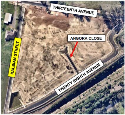
Figure 1 – Current
assigned name for proposed street in Austral
The applicant has requested the street be renamed to reflect their
family who owned the property.
The applicant has provided information about her late grandparent,
to support the application (Attachment 1). Catanzariti
Drive is consistent with the Austral street naming
theme and has been granted pre-approval from the Geographical Names Board.
Next
Steps
If
supported by Council, the name will be forwarded to the GNB for formal approval
and if approved, placed on public exhibition for 28 days on Council’s
website and notified to relevant stakeholders, seeking endorsement.
Relevant
stakeholders include Australia Post, NSW Ambulance, Fire and Rescue NSW, NSW
Rural Fire Service, NSW State Emergency Service, NSW Volunteer Rescue
Association, Transport for NSW and NSW Police Force.
Council
officers will consider all submissions during the public notification period.
The three potential scenarios following exhibition are as follows:
· If there are objections from the relevant agencies,
Council will not proceed with the naming request. The applicant will be
notified of the outcome. A report to Council will be prepared for the next
available meeting outlining the reason for rejection.
· If there are no objections, the naming request will
proceed to the NSW Parliamentary Counsel’s Office (PCO) for gazettal
under the delegation of the Chief Executive Officer (or delegate).
· Any submissions from the community during the public
notification period will be considered. If there is strong community
opposition, or reason to reconsider the proposed names, a report will be
prepared for the next available Council meeting recommending withdrawal of the
naming proposal. If Council decides to support the proposal, the naming request
will proceed to the PCO for gazettal under the delegation of the Chief
Executive Officer (or delegate). If Council decides not to adopt the naming
proposal, the applicant will be notified in writing outlining the reason for
rejection.
|
Economic
|
There are no economic and financial considerations.
|
|
Environment
|
There are no environmental and sustainability considerations.
|
Social
|
Preserve and maintain heritage, both landscape and cultural as urban
development takes place.
|
Civic
Leadership
|
Foster neighbourhood pride and a sense of responsibility.
|
|
Legislative
|
Roads Act 1993.
|
|
Risk
|
There is no risk associated with this
report.
|
1. Additional
information in support of street renaming to Catanzariti Drive
|
0
|
|
EGROW
05
|
Street
Naming Request - Austral
|
|
Attachment
1
|
Additional
information in support of street renaming to Catanzariti Drive
|
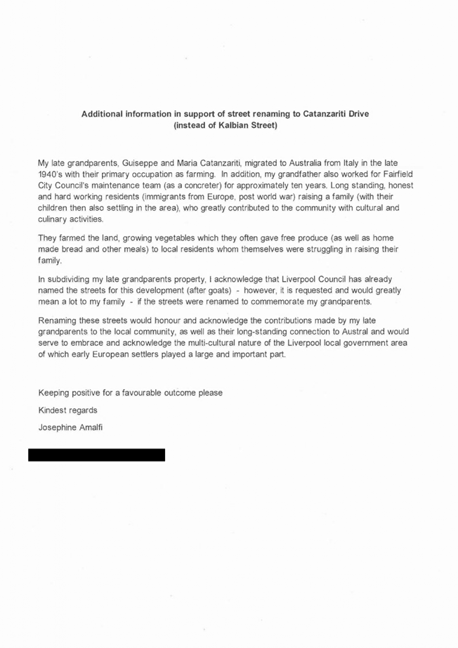
Ordinary Meeting
26 August 2020
City Community and Culture Report
|
COM 01
|
Report back to Council - Alcohol-Free
Zones Public Exhibition
|
|
Strategic
Direction
|
Creating
Connection
Create a
dynamic, inclusive environment, including programs to support healthy living
|
|
File Ref
|
194252.2020
|
|
Report By
|
Galavizh
Ahmadi Nia - Manager Community Development and Planning
|
|
Approved
By
|
Tina
Sangiuliano - Acting Director City Community and Culture
|
At its meeting on 29 April 2020, Council resolved to:
1. Endorse the recommended sites for
re-establishment of Liverpool Alcohol-Free Zones (AFZs);
2. Place the recommended AFZs on public
exhibition for a period of 30 days as required by the Ministerial Guidelines on
Alcohol-Free Zones; and
3. Delegate to the CEO the
finalisation of the recommended
AFZs if no
submissions are received; or receive a further report outlining details of the
submissions received at the conclusion of the exhibition period.
The endorsed Alcohol-Free Zones (AFZs) sites were
placed on public exhibition for a period of 30 days, commencing 13 May 2020.
One submission from a member of the public was received during the public
exhibition period. This submission recommended that Council consider including
Collimore Park as an AFZ site and installing an AFZ sign.
In consultation with relevant stakeholders, including
the Liverpool City Police Area Command, Council staff have determined
installing an AFZ sign in Collimore Park would be beneficial to ensuring the
safety and wellbeing of community members. Subsequently, the additional site
was submitted to the Anti-Discrimination NSW for endorsement. The
Anti-Discrimination NSW has confirmed that Council has complied with the
required 30-day public exhibition period for AFZs and the new AFZ in Collimore
Park does not require a further period of public exhibition.
|
That Council
endorse the re-establishment of Liverpool’s Alcohol-Free Zones for a
period of four years to 1 September 2024.
|
1. BACKGROUND
AFZs are implemented as an early
intervention method to prevent the escalation of irresponsible street drinking.
The AFZs aim to:
· Create easily identifiable locations where street
drinking is prohibited;
· Intervene and prevent the escalation of irresponsible
street drinking;
· Reduce and prevent alcohol related crime and
behaviour;
· Inform and educate community members about
the importance of eradicating alcohol consumption within these areas;
· Create a safe environment for all community members;
· Provide opportunities for collaboration with the
Liverpool City Police Area Command and relevant community organisations to
promote healthier behaviours; and
· Monitor alcohol consumption in known hotspot
locations.
Liverpool’s AFZs identify small areas of public
space, typically in locations adjacent to outlets supplying alcohol such as
pubs, clubs and liquor stores, where the consumption of alcohol is prohibited.
Liverpool City’s AFZs were implemented and enforced for a four-year
period from 2015 to 2019. The AFZs have been implemented in known hotspots for
inappropriate street drinking, aiming to create a safer environment for
community members. These locations were identified in consultation with local
Police, service providers, and internal stakeholders including the Community
Standards team.
2. RENEWAL PROCESS
The Ministerial Guidelines for AFZs, overseen by
Anti-Discrimination NSW, requires that requests for AFZs must be made to
Council by a member of the NSW Police Force, community organisation or a member
of the general public. The proposed zones are then submitted to
Anti-Discrimination NSW, the approving authority, for their review and
approval. This process also requires a public exhibition period of 30 days to
allow comment and feedback from the community.
36 zones were submitted to the Anti-Discrimination NSW
on 24 January 2020 for renewal. Correspondence received from the
Anti-Discrimination NSW on 2 March 2020 has authorised Council to reestablish
Liverpool’s AFZs.
3. PUBLIC EXHIBITION
Liverpool’s proposed AFZs were placed on public
exhibition on 13 May 2020 for a period of 30 days. One response was received
from a member of the public recommending Collimore Park as an AFZ site.
Collimore Park is a high traffic area due to its proximity to residential
buildings, popular public amenities such as basketball courts and play
equipment, and copious access to free commuter parking.
4. OUTCOME
Council officers have consulted Liverpool City Police
Area Command on the recommendations to include Collimore Park in the AFZs.
Police have agreed the site would benefit from being included as an AFZ in
Liverpool. Subsequently, Council
submitted an application to the Anti-Discrimination NSW to include Collimore
Park as an AFZ in Liverpool. Advice received from the Anti-Discrimination NSW
confirms that Council has complied with the required 30-day public exhibition
period for AFZs and the new AFZ in Collimore Park does not require a further
period of public exhibition.
The AFZs signs will be in place and enforced from 1
September 2020. Existing signage in Liverpool’s AFZs
is out-of-date and reflects the previous AFZ term. As part of the renewal
process, up-to-date signage stipulating the new enforcement dates will be
installed in all identified locations. The new signs will be treated with a
UV-resistant coating to ensure the signs’ longevity and prevent fading.
5. ENFORCEMENT
Once implemented, the AFZs may be enforced
by any officer of the NSW Police Force.
The power to seize and tip out or otherwise
dispose of alcohol without the need to issue a warning applies within an
alcohol-free zone. A Police Officer may use their discretion to issue a warning
to a person who is drinking in an alcohol-free zone. An individual who does not
comply with an AFZ, at the direction of a Police Officer can be charged with
obstruction under Section 660 of the Local Government Act 1993. This offence
carries a maximum penalty of $2,200.
6. IMPLEMENTATION
It is recommended that Council endorse the
re-establishment of Liverpool’s Alcohol-Free Zones for a period of four
years to 1 September 2024. Up-to-date signage will be installed in all
locations by 30 September 2020.
|
Economic
|
There are no economic and financial considerations.
|
|
Environment
|
There are no environmental and sustainability
considerations.
|
Social
|
Support policies and plans that prevent crime.
|
Civic
Leadership
|
There are no civic leadership and governance
considerations.
|
|
Legislative
|
There are no legislative considerations relating to
this report.
|
|
Risk
|
There is no risk associated with this
report.
|
Nil
Ordinary Meeting
26 August 2020
City Community and Culture Report
|
COM 02
|
Report Back to Council - Mimosa Park,
22 Box Rd, Casula
|
|
Strategic
Direction
|
Creating
Connection
Implement
access and equity for all members of the community
|
|
File Ref
|
201003.2020
|
|
Report By
|
Galavizh
Ahmadi Nia - Manager Community Development and Planning
|
|
Approved
By
|
Tina
Sangiuliano - Acting Director City Community and Culture
|
In response to a Council resolution from 31 July 2019,
a report was presented to Council’s meeting on 11 December 2019,
exploring opportunities for the repurposing of Council owned or controlled land
in the Local Government Area (LGA) for the purpose of affordable housing. At
this meeting, Council resolved to:
1. Keep the vacant block of land on 22 Box
Road Casula, for it to be turned into a park;
2. Prepare a report outlining options for
community use of the land including consultation of the local residents and
also consider only unused and underutilised land;
3. Be provided with funding options to
implement above or alternate options;
4. Note that 22 Box Road, Casula (this block
is approximately 550 sqm) is currently zoned RE1 public recreation and is
surrounded by R2 low density residential;
5. Receives and notes the report and has a
further briefing in March 2020 and makes available all reports regarding land
usage that is underutilised. Councillors be provided with any other relevant
reports given to the previous term of Council.
This report responds to resolutions 1 – 4 above,
including a review of key planning and recreation
strategic documents, site feasibility and analysis, and a review of
existing recreation infrastructure around the subject site, being 22 Box Rd, Casula. The report
presents the key findings of the above review and recommends options to develop
the site for community’s recreational use; and options for funding and
delivery of Mimosa Park.
In reference to the response to resolution
point 5. Councillors be provided with all reports regarding land usage that is
underutilised and any other relevant reports given to the previous term of
Council, this has been referred to Property, who will provide a report to the
November 2020 Council meeting.
|
That Council:
1. Receives and notes the report; and
2. Subject to Council’s decision to develop Mimosa Park into a
local park for community use, allocate funds to planning delivery stages;
3. Commission a site feasibility study and environmental testing; and
4. Commission a detail design stage including concept designs for
community consultation and construction.
|
1. Background
At the Ordinary meeting held on 31 July 2019, Council
resolved to:
· Direct the CEO to provide a report back to Council by
December 2019 detailing opportunities for the repurposing of Council owned or
controlled land in the LGA for the purpose of affordable housing, noting any
action on any report will be subject to community consultation
In response to Council’s resolution of 31 July
2019, a report was presented to Council at its meeting held on 11 December
2019, exploring the opportunities for the repurposing of the Council owned or controlled
land in the LGA for the purpose of affordable housing. Based on the broad
outcomes of the Community Facilities Strategy and the State Environmental
Planning Policy (SEPP) 2019 (Affordable Rental Housing), the report produced a
detailed investigation of the identified land parcels as suitable land/s to be
repurposed for affordable housing. At its meeting held on 11 December 2019,
Council resolved to:
1. Keep the vacant block of land on 22 Box Road Casula,
in order for it to be turned into a park;
2. Prepare a report outlining options for
community use of the land including consultation of the local residents and
also consider only unused and underutilised land;
3. Be provided
with funding options to implement above or alternate options;
4. Note that 22
Box Road, Casula (this block is approximately 550 sqm) is currently zoned RE1
public recreation and is surrounded by R2 low density residential;
5. Receives and notes the report and has a
further briefing in March 2020 and makes available all reports regarding land
usage that is underutilised. Councillors be provided with any other relevant
reports given to the previous term of Council.
This report responds to items 1 – 4 of the
resolution and presents the key findings from the review of planning documents,
site feasibility and analysis review, and recommends funding options to develop
Mimosa Park for community’s recreational use. In reference to the response to resolution point 5.
Councillors be provided with all reports regarding land usage that is
underutilised and any other relevant reports given to the previous term of
Council, this has been referred to Property, who will provide a report to the November
2020 Council meeting.
2. Strategy Review - Recreation, Open Space and Sports
Strategy (ROSS Strategy)
Adopted in 2018, the ROSS Strategy is a principal
document that provides direction and guidance to Council for planning and
development of Public Recreation (RE1) land. This includes planning for the
current and future recreation, open space and sporting needs in the Liverpool
LGA. The ROSS Strategy provides guidance on the delivery of high quality,
integrated and multi-functional, recreation, open space and sporting
infrastructure.
The ROSS Strategy recognises the undersupply of active
and passive recreation facilities across the LGA, specifically in the new
release suburbs of Austral, Carnes Hill, Edmondson Park and Middleton Grange.
It also provides hierarchy classification for parks and open spaces.
Mimosa Park is classified as a local park. The fundamental function of a local park is to provide for
a basic playground and connectivity to open space network. Local parks are
generally utilised on a daily basis by the residents in the immediate catchment
area (400m radius- 4-5 min walking distance).
The table below presents the classification of open space as per ROSS Strategy:
|
Classification
|
Size (sqm)
|
Description
|
|
Regional
|
10,000
or more
|
Within
5km of homes and places of work:
· 5 minute drive
· 15-20min bike ride
|
|
District
|
5,000-10,000
|
1-2 km safe
walking distance:
· 15-20 minute walk
· 5 minute bike ride
|
|
Neighbourhood
|
1,500-5,000
|
800m
safe walking distance:
· 10 minute walk
|
|
Local
|
500-1,500
|
400m safe
walking distance:
· 5 minute walk
|
|
Pocket
|
100-500
|
200-400m
safe walking distance:
· 2-5 minute walk
|
In addition, one of the strategic actions within the
ROSS Strategy currently being investigated by Council staff is an audit of the
existing parks and open spaces across the Liverpool LGA. This audit will be a
critical tool to document and assess the provision of facilities within
existing parks and open spaces. The audit of existing provision of facilities
will be evaluated against the required facilities as per the hierarchy and
specifications of open space identified in the ROSS Strategy. This evaluation
will assist Council in identifying gaps within the provision of facilities and
guide the process of upgrading parks and open spaces to high quality,
multipurpose and adaptive places. The audit findings will also assist in
identifying unused and/or underutilized open spaces within the LGA, which could
be included in the upgrade program or repurposed for other uses.
3. Need and demand
analysis
Current parks and open spaces in Casula
The table below outlines the current
provision of parks and open spaces within a 1,200m catchment area of Mimosa
Park.
|
|
Name and location
|
ROSS Strategy classification
|
Main functions
|
Approx. distance from Mimosa Park
|
|
A.
|
Daruk Park,
Casula
Ingham Drive
|
District Park
|
· Sports field
· Amenity building
· Community centre
· Library
|
820m
|
|
B
|
Jardine Park, Casula
Reserve Road
|
District Park
|
· Sports field
· Basketball court
· Netball court
· Playground
· Amenity building
|
1.5k
|
|
C
|
Peter Miller
Reserve, Casula
Cedar Road
|
District Park
|
· Sports field
· Basketball half court
· Cricket nets
· Playground
· Amenity building
|
280m
|
|
D
|
Gandangara Park, Casula
Strawberry Road
|
Neighbourhood Park
|
· Drainage corridor
· Pedestrian pathway
|
700m
|
|
E
|
Tharawal
Park, Casula
Gunsynd Avenue
|
Local Park
|
· Children’s playground
|
1.3km
|
|
F
|
Bill Wilson Park, Casula
Maple Road
|
Local Park
|
· Children’s playground
· Picnic shelters
|
1.5km
|
|
G
|
Acacia Park,
Prestons
72A Grevillea
Crescent
|
Local Park
|
· Children’s playground
· Picnic shelters
|
500m
|
Table 3.1: Classification of parks and their function
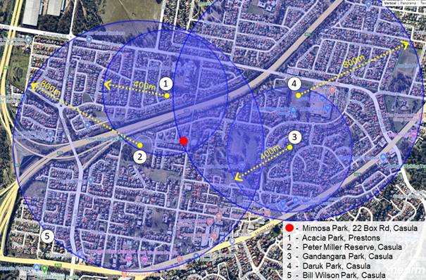
Figure 3.2: Catchment area of
accessible parks around Mimosa Park
In reference to table 3.1 and figure 3.2,
the community residing around Box Rd has access to the following hierarchy of
parks:
· Peter Miller Reserve - District Park;
· Acacia Park - Local Park;
· Gandangara Park - Neighbourhood Park;
· Daruk Park - District Park; and
· Mimosa Park - classified as a local park
and serves the daily needs of the residents in the area.
Demand analysis of parks and open spaces in Casula
It is estimated that Casula will have a shortfall of
4.97ha of sportsground and a surplus of 9.97ha of parks and open space by 2031[1].
It should be noted that approx. 30% of the surplus in the local park network
fall within the riparian zones along creeks, and approx. 60% falls within the
1:100 flood plain. Therefore, of the 9.97ha of surplus parks and open space,
approximately 90% of the land is subject to some level of restrictions, and
their functions and opportunities for access by community will be limited.
Site Feasibility and Analysis of the park
Site Analysis:
Mimosa
Park is grassed and is currently maintained by Council’s City Presentation team. The land is fully
vacant and serves no purpose for community use.
The land drops approximately 4-5 metres from the front of the site to the back and has a gradient
close to 1:10, which would require extensive earthwork and retaining walls to
install a playground. The Preliminary site analysis has identified major
upgrade requirements to make the site safe, including the construction of a
retaining wall, back filling, levelling and fencing. Due to the topography
conditions, the site does not meet the requirements for provision of an
inclusive playground.
To
meet the community requirements, a playground, outdoor gym, shade and circular
walking tracks are provided at Peter Miller Park, which is within the catchment
of this park, approximately 170 metres away. In addition, there is no fencing
between Council’s property and the private properties at this site, which
is considered a risk to children accessing the park.
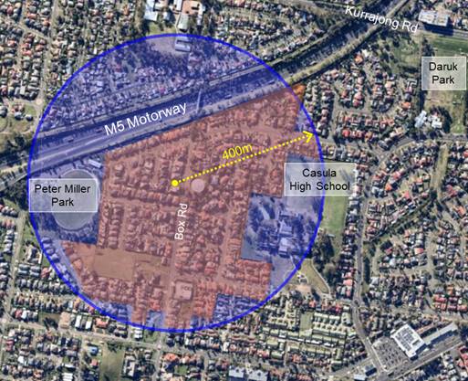
Figure 3.3: Primary catchment area of
Mimosa Park
Site feasibility:
Mimosa
Park is classified as a local park. Currently, Mimosa Park is a small,
undeveloped area of land located within the residential area at the western end
of Box Rd, Casula. Considering the size and grade of Mimosa Park, it can only
provide limited recreational opportunities.
The table below provides a brief description of the
facilities to be considered for Mimosa Park:
|
Recommended Functions
|
Description
|
Specifications
|
|
Play area
|
Natural
play area
|
· Nature play
· Wooden logs at different heights to climb
· Natural hills and mounds utilising the site
topography
· Stepping stone play
|
|
Connectivity
|
Transparency and
inclusivity with playground spaces
|
Connectivity to
the existing footpath on Box Rd
|
|
Trees
|
· Shade providing trees
· Garden beds
|
Visibility
to the street
|
|
Passive
open space
|
Grassed area for
informal play
|
The park is sloped
(1:10) towards the rear, then drops dangerously near the rear properties
|
|
Informal seating
|
Informal
seating benches
|
Benches
and informal seating
|
Table 3.4: Functional Brief of proposed facilities at Mimosa Park
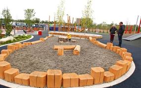
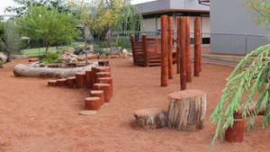
Fig 3.5:
sample image of natural play area
4. Funding and delivery
options
The
design stages (concept and detailed) and the construction of local parks such
as Mimosa Park are ideally identified within the Capital Works Program for a
particular financial year,
whereas the construction cost is identified within the Contributions Plan for
the suburb/area.
The collected contributions for the established areas
of Liverpool LGA are either exhausted or insufficient to
deliver all parks and open spaces (new works and upgrade works). Currently,
there is a limitation within the collected contributions for the capital works
program, which only allows for basic embellishments for a given park. This
creates a gap in funds available for the delivery of high quality, versatile
and inclusive parks and open space.
Despite its open space zoning, Mimosa Park has not
been identified as a contribution plan item. At present, there is no ability to
fund Mimosa Park through infrastructure contribution. The Park is not
identified as an item in Liverpool Contributions Plan 2009 (Cabramatta
Creek/Carnes Hill/Prestons). As such, funds cannot be allocated to the upgrade
of this open space from contributions, which require Council to identify and
allocate a funding source. The remaining funds for open space in this catchment
are required to support open space projects still to be delivered under
Contributions Plan 2009.
It is noted that Contributions Plan 2009 identified
Peter Miller Park as the key open space precinct within this area. Over 15
years ago, Council invested in excess of $3,000,000 to deliver Peter Miller
Park.
It is recommended to undertake further site
investigations, including environmental testing to determine the feasibility of
the site, develop a concept design and complete community consultation. The high level costing for development and
construction stage of this project is estimated at $150,000. Budget phasing is
outlined in the table below:
|
YEAR
|
ITEM
|
BUDGET
|
|
2020/21
|
Feasibility
Study, Environmental Testing, Concept Development, Community Consultation
|
$10,000
|
|
2021/22
|
Detail
Design, Procurement and Construction
|
$140,000
|
The table below outlines a high-level timeline for the
project development and delivery stages:
|
Development stage 2020/21
|
Estimated duration
|
|
a. Needs, demand analysis; and feasibility
analysis
|
2 weeks
|
|
b. Site environmental testing
|
12 weeks
|
|
c. Developing concept design (subject to
availability of funding)
|
4 weeks
|
|
d. Stakeholder consultation:
· Internal Stakeholders
· Local community consultation: Liverpool
Listens, Letter box drop, community notice boards, Pop-up stalls (subject to COVID-19
restrictions)
|
2 weeks
4 weeks
|
|
e. Review of stakeholder consultation
|
2 weeks
|
|
f. Amend concept design as per stakeholder feedback
|
2 weeks
|
|
g. Resident Notification Letter (Final
Concept)
|
2 weeks
|
|
Construction Stage 2021/22
|
Estimated duration
|
|
h. Detailed design
|
10 weeks
|
|
i. Procurement
|
10 Weeks
|
|
j. Construction, establishment and maintenance
|
20 weeks
|
5. Conclusion
With consideration to the hierarchy of open space
identified in Council’s ROSS Strategy, Mimosa Park is classified as a
local park. The park is surrounded by low density residential. As a local park,
Mimosa Park will respond to the daily recreation needs of the local community
and will serve as a place for relaxation and play. Aligned with the
specifications of a local park, this report proposes a natural play space
(natural playground), tree planting, grassed informal play area and informal
seating benches.
Subject to the availability of funds, a project
program is required to be developed to stage the design and construction of the
park, inclusive of community consultation.
|
Economic
|
Currently no budget is allocated to deliver this project.
|
|
Environment
|
Raise community awareness and support action in relation to
environmental issues.
|
Social
|
Raise awareness in the community about the available services and
facilities.
Support access and services for people with a disability.
Deliver high quality services for children and their families.
|
Civic
Leadership
|
Act as an environmental leader in the community.
Undertake communication practices with the community and stakeholders
across a range of media.
Encourage the community to engage in Council initiatives and actions.
|
|
Legislative
|
There are no legislative considerations relating to
this report.
|
|
Risk
|
The risk level of this project is deemed
low. The risk is considered to be within Council’s risk appetite.
|
Nil
Ordinary Meeting
26 August 2020
City Community and Culture Report
|
COM 03
|
COVID-19
Impact on Sporting Field Hire Revenue
|
|
Strategic Direction
|
Creating Connection
Deliver a range of community events and activities
|
|
File Ref
|
203891.2020
|
|
Report By
|
Mark Westley - Manager Recreation and Community Outcomes
|
|
Approved By
|
Tina Sangiuliano - Acting Director City Community and Culture
|
The
COVID-19 shutdown period has had the effect of disrupting sporting field hirers
from running their winter season activities and consequently will then have a
flow on effect into the coming summer season.
Council
defines the winter season as between 1 March and 31 August. The month of
March typically sees winter sports finalising their pre-season preparation for
their competitions to commence early April. This year NSW Government
restrictions introduced in response to the COVID-19 pandemic in late March
resulted in hirers taking the responsible approach of initially postponing
their season start, and later in April the government restrictions mandated
that they were unable to commence their winter competitions.
In
June 2020 the NSW Government agreed that local sporting competitions could
resume for both junior and senior competitions from 1 July 2020 which resulted
in modified training resuming earlier in June. To support the resumption of
sport in our community Council supported a redefined 15 weekend winter season,
1 July to 11 October, agreed by the state sporting organisations representing the major football codes and
cricket and the subsequent modification of the coming summer season.
As a consequence
of COVID-19 sports associations and clubs within the LGA are reporting a
substantial loss of player registration and difficulty of fielding sufficient
teams to maintain competitions. The reduction in player registrations has
impacted the financial viability of some clubs where registration fees represent
an important source of revenue. In the case of the Liverpool City Robins
Soccer Club their season has been further impacted by the use of their home
ground as a NSW Health drive-through COVID Clinic.
Council’s
Fees and Charges document defines fees and charges for community
sporting groups based on a seasonal flat rate for field use and floodlighting.
The fee applied is the same whether the hirer uses the field 10 times or 26
times during the season. There is no ability for the reduction of the fees
payable by community sport except through Council resolution.
In
recognition of the impact on sports field hirers from the COVID-19 shutdown,
this report is provided to enable Council to establish a mechanism for the
application of a fee relief plan to reflect the reduced 2020 winter season, the
coming 2020/2021 summer season and the other impacts on Community sport.
|
That Council:
1. Endorse the application of approved
2019/2020 and 2020/2021 sporting field fees and charges on a pro-rata basis
for the 2020 winter and 2020/2021 summer seasons.
2. Endorse the waiving of winter
season 2020 fees charged to the Liverpool City Robins Sports Club.
|
The
COVID-19 shutdown period has had the effect of disrupting sporting field hirers
from running their winter season activities and will have a flow on effect into
the coming summer season.
Council
defines the winter season as between 1 March and 31 August. The month of
March typically sees winter sports finalising their pre-season preparation for
their competitions to commence early April. This year NSW Government
restrictions introduced in response to the COVID-19 pandemic in late March
resulted in hirers taking the responsible approach of initially postponing
their season start, and later in April the government restrictions mandated
that they were unable to commence their winter competitions.
In
June 2020 the NSW Government agreed that local sporting competitions could
resume for both junior and senior competitions from 1 July 2020 with modified
training resuming earlier in June. The state’s major football codes along
with Cricket lobbied support from local government agencies to adopt an agreed
winter season length of 15 weeks. To support the resumption of sport in our
community, and recognising the advantages of streamlining the winter sporting
season to be consistent with neighbouring Councils, Council staff supported the
redefined 15 weekend winter season between 1 July and 11 October.
Sporting
associations operating within the Liverpool LGA have taken a range of
approaches to the redefined season with the majority seeking to operate a
reduced season and others electing to cancel their season or run a yet to be
determined “spring” competition in the hope that the risk of
COVID-19 will be more settled at that time. The reality our community is
facing at this time is that there is no guarantee that winter sports will be
able to fulfil their redefined seasons due to the potential reintroduction of
COVID-19 restrictions that stop sport.
Sports
associations and clubs within the LGA are reporting a substantial loss of
player registrations. In addition to the difficulty of fielding
sufficient teams to maintain competitive competitions, the reduction in player
registrations has impacted on the financial viability of some clubs where
registration fees represent an important source of revenue.
Council’s
Fees and Charges document defines fees and charges for community
sporting groups based on a seasonal flat rate for field use and floodlighting.
The fee applied is the same whether the hirer uses the field 10 times or 26
times during the season. There is no ability for the reduction of the fees
payable by community sport except through Council resolution.
To support sports clubs and associations, through such
a challenging and unprecedented time, a mechanism is required to allow the
application of fees that reflects the reduced season. To achieve a reasonable compromise that
acknowledges the financial impact of COVID-19 on clubs and recognises that
Council continues to incur costs such as field preparation and floodlighting
costs, a pro-rata application of Council’s fees is proposed.
Under this formula the seasonal hire fee
applicable to a booking will be divided by the number of weeks in a regular
season (26 weeks). This weekly amount will then be multiplied by the
number of weeks in the redefined season. The pro-rata application of fees will
also enable Council to apply consistent fees to competitions that straddle the
redefined winter and summer seasons.
The financial impact of the pro-rata
application of fees on the 2020 winter season is detailed in the table
below. For the majority of sporting codes the application of a 15 week
competition will result in a 42% reduction in the fees payable to
Council. As illustrated in the table, the income invoiced by Council in the 19/20 financial
year for hirers opting to continue their winter competition will reduce by
$48,769 from $115,273 to $66,503.
|
Venue
|
Hirer
|
Total full season Charges
|
Revised Season Competition Length
Total Weeks
|
Proposed revised Charges
|
Discount on seasonal charges
|
|
Amalfi Memorial Park
|
FC Bossy Liverpool Youth
|
$ 3,029
|
15
|
$ 1,748
|
$ 1,282
|
|
Australis Park
|
Fight For it PT
|
$ 215
|
15
|
$
124
|
$
91
|
|
Australis Park
|
Commit2fit Personal Training
|
$ 215
|
15
|
$
124
|
$
91
|
|
Australis Park
|
Liverpool Oztag
|
$ 3,095
|
15
|
$ 1,786
|
$ 1,309
|
|
Brownes Farm Reserve
|
Dion Kallistros - fitness hirer
|
$ 215
|
15
|
$
124
|
$
91
|
|
Brownes Farm Reserve
|
Southern DIstricts Soccer Football Association (SDSFA)
|
$ 4,640
|
15
|
$ 2,677
|
$ 1,963
|
|
Bill Anderson Reserve
|
Kemps Creek United Soccer Club
|
$ 535
|
15
|
$
309
|
$
226
|
|
Blamfield Oval
|
Preston Soccer Club
|
$ 2,814
|
15
|
$ 1,623
|
$ 1,191
|
|
Bringelly Reserve
|
(SDSFA)
|
$ 3,029
|
15
|
$ 1,748
|
$ 1,282
|
|
Childs Park
|
Iron Up Fitness
|
$ 1,686
|
15
|
$
973
|
$
713
|
|
Venue
|
Hirer
|
Total full season Charges
|
Revised Season Competition Length
Total Weeks
|
Proposed revised Charges
|
Discount on seasonal charges
|
|
Craik Park
|
West Sydney Gridiron
|
$ 2,424
|
15
|
$ 1,399
|
$ 1,026
|
|
Craik Park
|
Austral City Bears Rugby League Football Club
|
$ 2,142
|
15
|
$ 1,236
|
$
906
|
|
Daruk Park
|
Casula Lakers Baseball Club
|
$ 1,663
|
15
|
$
960
|
$
704
|
|
Durrant Oval
|
(SDSFA)
|
$ 6,058
|
15
|
$ 3,495
|
$ 2,563
|
|
Dwyer Oval
|
Liverpool City Cougars JRUC
|
$ 1,753
|
15
|
$ 1,011
|
$
742
|
|
Edwin Wheeler Oval
|
South West Wanderers
|
$ 2,035
|
15
|
$ 1,174
|
$
861
|
|
Ernie Smith Reserve - Soccer
|
(SDSFA)
|
$ 2,942
|
15
|
$ 1,697
|
$ 1,245
|
|
Freeman Oval
|
Werriwa All Breeds Dog Training Club Inc
|
$
67
|
15
|
$
39
|
$
28
|
|
Greenway Park
|
Tekniq Training
|
$ 1,686
|
15
|
$
973
|
$
713
|
|
Greenway Park
|
South West Tigers Junior AFL
|
$ 4,567
|
15
|
$ 2,635
|
$ 1,932
|
|
Greenway Park
|
Roy Gallucio / The Athletic Hub
|
$ 2,317
|
15
|
$ 1,337
|
$
980
|
|
Hammondville Park - Cricket
|
Sydney Junior Winter Cricket Association
|
$ 384
|
15
|
$
222
|
$
163
|
|
Hammondville Park - Netball
|
Moorebank Sports Netball Club
|
$ 2,241
|
15
|
$ 1,293
|
$
948
|
|
Hammondville Park - Soccer
|
Moorebank Sports Soccer Club
|
$ 623
|
15
|
$
360
|
$
264
|
|
Hillier Oval
|
All Saints JRLC
|
$ 3,029
|
15
|
$ 1,748
|
$ 1,282
|
|
Hoxton Park Reserve
|
Liverpool Olympic Sports & Social Club
|
$ 3,365
|
15
|
$ 1,942
|
$ 1,424
|
|
Ireland Park
|
Liverpool Rangers Soccer Club
|
$ 5,103
|
15
|
$ 2,945
|
$ 2,159
|
|
Jardine Park
|
Casula United Football Club
|
$ 3,029
|
15
|
$ 1,748
|
$ 1,282
|
|
Kokoda Oval
|
Sydney Junior Winter Cricket Association
|
$ 384
|
15
|
$
222
|
$
163
|
|
Venue
|
Hirer
|
Total full season Charges
|
Revised Season Competition Length
Total Weeks
|
Proposed revised Charges
|
Discount on seasonal charges
|
|
Larry Grant Oval (Landa Park)
|
Hinchinbrook Sports Club
|
$ 4,146
|
15
|
$ 2,392
|
$ 1,754
|
|
McGirr Park
|
Green Island FC/Australian North Cyrpus Friendship
Association
|
$ 1,471
|
15
|
$
849
|
$
622
|
|
Paciullo Oval
|
Flow Futbol Academy
|
$ 2,599
|
15
|
$ 1,499
|
$ 1,100
|
|
Paciullo Oval
|
Sydney Junior Winter Cricket Association
|
$ 384
|
15
|
$
222
|
$
163
|
|
Paciullo Oval
|
Liverpool Touch Football
|
$ 1,753
|
15
|
$ 1,011
|
$
742
|
|
Paciullo Oval
|
Ultimate Frisbee
|
$ 3,506
|
15
|
$ 2,023
|
$ 1,483
|
|
Peter Miller Park
|
Liverpool Eagles Junior AFL
|
$ 2,424
|
15
|
$ 1,399
|
$ 1,026
|
|
Powell Park
|
Sydney Morning Cricket Association
|
$ 384
|
15
|
$
222
|
$
163
|
|
Riverside Park
|
Canterbury Bankstown District Baseball Club Inc
|
$ 3,711
|
15
|
$ 2,141
|
$ 1,570
|
|
Ron Darcy Oval
|
Kraljeva Sutjeska Social Soccer Club
|
$ 1,753
|
15
|
$ 1,011
|
$
742
|
|
Rosedale Oval
|
South West Sydney Magpies AFL
|
$ 2,706
|
15
|
$ 1,561
|
$ 1,145
|
|
Scott Memorial Park
|
Austral Soccer Club
|
$ 535
|
15
|
$
309
|
$
226
|
|
Schell Park
|
Sydney Junior Winter Cricket Association
|
$ 307
|
15
|
$
177
|
$
130
|
|
South Park
|
Chipping Norton FC
|
$ 5,350
|
15
|
$ 3,087
|
$ 2,263
|
|
Stanwell Oval
|
(SDSFA)
|
$ 3,029
|
15
|
$ 1,748
|
$ 1,282
|
|
Whitlam Park No.2
|
(SDSFA)
|
$ 3,029
|
15
|
$ 1,748
|
$ 1,282
|
|
Whitlam Park No.3 and No.4
|
(SDSFA)
|
$ 6,058
|
15
|
$ 3,495
|
$ 2,563
|
|
Wheat Park
|
Liverpool Sports Club
|
$ 3,029
|
15
|
$ 1,748
|
$ 1,282
|
|
Winnal Reserve
|
Hinchinbrook Hornets
|
$ 3,808
|
15
|
$ 2,197
|
$ 1,611
|
|
|
|
Total full season Charges
|
|
Proposed revised Charges
|
Total Discount on full seasonal
charges
|
|
|
TOTALS
|
$115,273
|
|
$ 66,503
|
$ 48,769
|
It
should be noted that the following hirers have opted to cancel their winter
season use and will receive a full refund of fees and charges.
|
|
|
Total full season Charges Refunded
|
|
Peter Miller Park
|
Club Marconi
|
$
2,317
|
|
Childs Park Netball
|
Chipping Norton Netball Club
|
$
1,576
|
|
Jacquie Osmond Reserve
|
Southern Districts Softball Association Inc
|
$
1,471
|
|
Woodward Park Netball
|
Liverpool Netball Association
|
$
7,870
|
|
|
Total
|
$ 13,234
|
Additionally,
the Liverpool City Robins Sports Club based at Ash Road Sporting Complex have
had their access to this venue impacted greatly by the NSW Health
Department’s use of this venue as a COVID-19 testing Clinic. The clinic
commenced 14 July and currently is due to finish at the end of August although
a further extension is likely. Council has relocated club training where
possible however, in recognition of the disruption caused, it is proposed that
Council waive all winter season hire fees applied to the Liverpool City Robins.
Under the pro-rata mechanism this is a waiver of $4,164.
|
Venue
|
Hirer
|
Total full season Charges
|
Revised Season Competition Length
|
Proposed revised Charges
|
Discount on seasonal charges
|
|
Ash Road Sports Complex
|
Liverpool City Robins Sports Club
|
$ 7,217
|
15
|
$ 4,164
|
$ 3,054
|
The
ongoing threat of COVID-19 within the community means that there is no
guarantee that winter sports will get to complete their season and the pro-rata
fees system will allow Council the flexibility to adjust fees payable by hirers
should the reintroduction of COVID-19 restrictions further reduce the winter
season.
In
terms of the 2020/2021 summer sporting season, Council will again align itself
with the collective position received from state sporting organisations
representing the major football codes and cricket, which defines the season as
starting 17 October and finishing no later than 5 April 2021. This
represents a 25-week season for full season competitions.
Given
the possibility of further COVID-19 impact it is proposed that Council also
apply fees for the summer season on a pro-rata basis which allows Council to
accommodate sports who have cancelled completely their winter competitions and
are planning “spring” competitions that will straddle the winter
and summer seasons.
This
position will have approximately a 4% reduction on summer season income where
the entire summer season is played without COVID-19 interruption.
Community
sporting clubs and physical exercise activities conducted in Council’s
parks and reserves are a vital part of the creation of connection and
liveability of our city. It is important that Council responds to the
impact of COVID-19 on these organisations and providers in a balanced
sustainable way.
|
Economic
|
The pro-rata mechanism will reduce the income invoiced by Council
in the 19/20 financial year by $48,769 from $115,273 to $66,503.
Fee relief will assist the financial sustainability of community
sport during the COVID-19 pandemic.
|
|
Environment
|
There are no environmental and sustainability considerations.
|
Social
|
Support community organisations, groups and volunteers to deliver
coordinated services to the community.
|
Civic Leadership
|
There are no civic leadership and governance
considerations.
|
|
Legislative
|
There are no legislative considerations relating to
this report.
|
|
Risk
|
There is no risk associated with this report.
|
Nil
Ordinary Meeting
26 August 2020
City Community and Culture Report
|
COM 04
|
Collingwood Visitation Precinct
Masterplan
|
|
Strategic
Direction
|
Creating
Connection
Implement
access and equity for all members of the community
|
|
File Ref
|
206666.2020
|
|
Report By
|
Galavizh
Ahmadi Nia - Manager Community Development and Planning
|
|
Approved
By
|
Tina
Sangiuliano - Acting Director City Community and Culture
|
At its meeting on 27 May 2020, Council
resolved to prepare a Masterplan for the Collingwood Visitation Precinct
(Collingwood Precinct).
The development of the Collingwood Precinct represents a unique
opportunity for Council to advantageously position this iconic site in
alignment with key growth trends occurring and emerging in Liverpool.
Envisioning the Collingwood Precinct as a cultural and historical gateway for
local residents and tourists, the site will preserve and recognise the values,
virtues, and vision of a diverse community that call Liverpool home.
Collingwood Precinct was listed as an Aboriginal
Place, under the National Parks and Wildlife Act 1974, on 6 March 2009. The
Aboriginal Place is associated with early engagement, and at times conflict,
between colonial settlers and Aboriginal people.
Originally known as Bunker’s Farm, the Collingwood Precinct
represents a rare and insightful glimpse into the development and expansion of
colonial settlement in the Liverpool region, providing evidence as an
influencer of agricultural, economic, and industrial growth for the area.
Today, the Collingwood Precinct Aboriginal Place is
important to Aboriginal people because the location and outlook provide a
connection to Country and culture. The site also continues to be used as a
meeting place by Aboriginal community.
Currently located at the Collingwood
Precinct are the Liverpool Regional Museum, the Collingwood House and Discovery
Park. It is a place of significant cultural and heritage value for the
Aboriginal Community, coupled with an important colonial history. These factors
place the Collingwood Precinct among the most unique places in Liverpool.
The development of the Collingwood Precinct establishes a
significant benefit between
linking heritage and tradition, local connection, national recognition, and
global interest, and has the potential to command national and international
attention to install Liverpool as an unmissable travel destination.
The redevelopment of Collingwood Precinct will be a proactive response to the projected
economic growth in Liverpool, the projected tourist traffic generated from
the
future Western
Sydney Airport, and the proximity to
the City Centre and the Georges River. The Masterplan will seek to further
enhance Liverpool’s reputation as a welcoming place for all and provide
an opportunity to deeply explore and connect the many cultural, historical, and community-driven aspects that contribute to Liverpool’s diversity by:
· Establishing a First Nations’ culture
and heritage centre, with indoor and outdoor areas devoted to telling the
stories of and celebrating the culture of the local Indigenous communities
past, present and emerging;
· Preserving the post-colonial character and
connect Collingwood Precinct to the Museum (and possibly the Library Heritage
Section) and the School of Arts, using the Georges River walk/cycleway;
· Connecting Collingwood Precinct to Casula
Parklands, Environmental Education Centre, Casula Powerhouse Art Centre and
Georges River;
· Increasing accessibility and connectivity
of Collingwood Precinct to significant transport modes, and pedestrian and bike
networks; and
· Developing the open space and parklands
that celebrates the Aboriginal heritage, the colonial history and today’s
multicultural city.
There is currently no funding included in
Council’s 2020/2021 budget for this project. The engagement of a
consultant to undertake the Masterplan process is estimated to cost between
$150,000 and $200,000.
This report seeks endorsement for the allocation of
funds for the development of the Masterplan
for the Collingwood Precinct to
include existing infrastructure and assets. A Conservation Management Plan is currently being prepared
for Collingwood House, which will be a key reference document for the
preparation of the Masterplan.
The Masterplan
scope will include
the cost estimate
of recommended redevelopments and will form the
basis
to lobby
the
State and Federal
Governments for funding.
|
That Council:
1. Receives and notes the report; and
2. Endorses funds of $150,000 – 200,000 in
the 2020/21 financial year to engage a consultant to undertake the
Masterplan.
|
1. Background
At the Ordinary Meeting held on 27 May
2020, Council resolved to:
1. Prepare
a Masterplan for a Visitation Precinct that includes:
· Collingwood
House;
· Liverpool
Museum;
· New
Liverpool Historical Society building;
· An
Aboriginal Arts, Culture and Learning facility;
· Café;
and
· Car and Bus Parking.
For
the land bounded by the Hume Highway, Congressional Drive and Birkdale Crescent
Liverpool.
2. Prepare the Visitation Concept
Precinct Masterplan design and possible cost and Report back to Council at the
29 July Council Meeting in order to further place on Exhibition for Community
Consultation.
3. Lobby State and Federal Governments
for funding and include the Visitation Precinct Masterplan in the 10-year plan
of Council.
4. Consider the Government initiative
for TCorp loans for community projects that could be applicable for this
project at the next Budget Review Meeting.
There is currently no funding included in
Council’s 2020/2021 budget for this project. The engagement of a
consultant to undertake the Masterplan process is estimated to cost between
$150,000 and $200,000.
This report seeks endorsement for the allocation of
these funds for the development of the masterplan for Collingwood Precinct to
include existing infrastructure and assets. A Conservation Management Plan is
currently being prepared for Collingwood House, which will be a key reference
document for the preparation of the Masterplan. The Masterplan scope will
include the cost estimate of recommended redevelopments and will form the basis
to lobby the State and Federal Government for funding.
Originally
known as Bunker's Farm, the estate was one of the earliest and largest land
grants in the Liverpool region, and influenced the economic growth of the
estate lands. This played an essential role in the development of agriculture
and early industries in the colony. The Collingwood Precinct is comprised of
three key assets:
· The Collingwood House and garden;
· The Liverpool Regional Museum; and
· The parklands,
inclusive of Discovery Park.
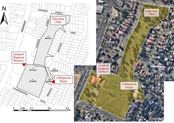
Figure 1.1: The scope of Collingwood Precinct
2. The historical context
of Collingwood Precinct
Aboriginal Significance
The Collingwood Precinct was listed as an Aboriginal
Place, under the National Parks and Wildlife Act 1974, on 6 March 2009. The land on which the Collingwood Estate
(Bunker’s Farm) is located is associated
with the Tharawal, Dharug and Gundungurra peoples. The Precinct is located within the boundaries of the Tharawal Local
Aboriginal Land Council (bordering Gandangara Local Aboriginal Land Council)
and is of significance to the Tharawal and Dharug people.
The hilltop and ridgeline at Collingwood are
understood to have been a meeting place for the Tharawal and Dharug people and
a vantage point enabling the Country to be observed and monitored. Aboriginal
community members have advised that when meeting, it was important for
Aboriginal people to be still able to see their own country. It is also
understood that this high point was used by Aboriginal people as a look out
across the Georges River to the East and the mountains to the West. The lookout
provided views across the landscape, which allowed for observations of weather
patterns, movements, threats from fire and changes in seasonal vegetation. The
'vista' from the high ground provides a view corridor southeast to the Georges
River.[2]
Aboriginal community members have advised that
Aboriginal artefacts have been found in the vicinity of the house and scarred
trees were a feature of the Collingwood Estate.
Today, the Collingwood Precinct Aboriginal Place is
important to Aboriginal people because the location and outlook provide a
connection to Country and culture. The site also continues to be used as a
meeting place for Aboriginal people. As such, input and directions on the
vision and aspiration for this Aboriginal significant place from the Aboriginal
community, including the Aboriginal Consultative Committee, Tharawal and
Gandangara Aboriginal Land councils and other key stakeholders will be of high
importance. Initial discussions have occurred with Tharawal Local Aboriginal
Land Council on the intention to redevelop this site. In these discussions,
Council have highlighted the importance of the land council’s playing a
key role in the planning and implementation of the Masterplan.
The Colonial Significance
The Collingwood House Estate is a remnant cultural
landscape that demonstrates the changing use and occupation of the site and the
significant transition of the place from an agricultural estate to an
industrial estate during the 19th century.
The homestead complex is a rare example of a modified
colonial Georgian residence that demonstrates the evolution of domestic
colonial architecture and its adaptation to the Australian environment from the
early 1800s to the early 1900s. It is one of only a small number of houses that
remain from the Macquarie period and one of only a small number of examples
remaining of the homesteads which once occupied the shores of the Georges
River, another being Glenfield Farm. The evolution of the house and its fabric,
dimensions, and layout are illustrative of the social and economic standing of
its various owners within the colony, their resources, and the genteel
lifestyle to which they aspired.[3]
The Liverpool Regional Museum
Liverpool Regional Museum was opened on 3 June 1989 as
part of Australia's Bicentennial celebrations. The museum was initially managed
by the Liverpool and District Historical Society, with Council assuming full
responsibility for the museum during the 1990s. The museum curates and exhibits
items reflecting environmental, heritage, and social themes within South-West
Sydney while preserving and promoting Liverpool's cultural heritage, history
and stories through collections, exhibitions, and public programs.
The Liverpool Regional Family History Centre
The Liverpool Regional Family History Centre opened in
August 2009, with the relocation of the Liverpool Genealogy Society from the
Liverpool City Library to the Liverpool Regional Museum. The Centre
features specialised family history resources and provides a unique
research centre for the study of worldwide family history. The Centre is
also home to the Liverpool Genealogy Society Inc. who together with the Council, has a
mutual interest in preserving, promoting, and providing access to a wide range
of family history resources.[4]
The Parklands/Discovery Park
Discovery Park was developed and officially opened by
Captain JA Shearing R.A.N on 7 March 1970 as Liverpool’s contribution to
the commemoration of Australia’s 200th Anniversary. Originally
located at the corner of George and Moore Streets, the site included a
relocated obelisk to serve as the centrepiece of Discovery Park and was
Liverpool’s contribution to the Bicentennial celebrations of the
‘discovery’ of Australia by Captain Cook.
In 2017, the obelisk was removed from Discovery Park,
and in 2018 was relocated back to Bigge Park and restored to its original
height and form.
Discovery
Park currently has little in the way of embellishments. There is a small garden area recognizing
Captain James Cook. There is no play equipment or park furniture.
3. Current context
|
Current
zoning
|
|
   
|
|
Total
area of Collingwood Precinct
(inclusive
of The Collingwood House, Liverpool Regional Museum and Discovery Park)
|
52,396.7
sqm/5.24ha
|
|
Current
use:
· Collingwood House- Normally open for heritage tours, but currently
closed for conservation works.
· The Liverpool Regional Museum and Family History
Centre- Visitors tours,
exhibitions, heritage, and other collections
· Discovery Park- Passive recreation
|
Collingwood Precinct, inclusive of the
Discovery Park, is zoned under RE1- Public Recreation. Discovery Park is
classified as a district level park and is surrounded by a network of local and
neighborhood parks and open spaces. The table below provides further
information on the surrounding land use and provision of parks and open spaces:
Local context:
The figure below records the existing network of parks
and open spaces around Collingwood Precinct. Other local and neighborhood parks
include:
|
Park
|
Area
(sqm)
|
Classification
|
|
Hazel
Bradshaw Park
|
1,587
|
Neighborhood
Park
|
|
Congressional Park
|
557.40
|
Local Park
|
|
Kiwi
Grove
|
3,452
|
Neighborhood
Park
|
|
Everett Park
|
3,914
|
Neighborhood Park
|
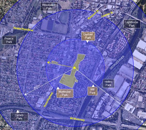
Figure 2.1: Existing parks and open spaces around
Collingwood Precinct
4. Strategic alignment
The
Masterplan will require alignment with the following strategies and plans:
· Liverpool Local Strategic Planning
Statement;
· Recreation, Open Space and Sports Strategy;
· Destination Management Plan;
· Liverpool City Centre Public Domain
Masterplan;
· Georges River Parklands and Chipping Norton
Lakes Spatial Framework - A Masterplan process will be commenced in August
2020;
· Connectivity to the proposed Environmental
Education Centre at Casula Parklands;
· Western Sydney District Plan;
· Collingwood Precinct Plan of Management
(2011); and
· Conservation Management Plan for
Collingwood House.
There is an excellent opportunity for the Visitation
Precinct to be a key destination in a regionally significant green and cultural
precinct, including the Georges River Parklands, Casula Parklands, Casula
Powerhouse Arts Centre, and the future Environmental Education Centre.
5. Masterplan Scope
A workshop among key internal stakeholders
was conducted to formulate preliminary scope of the Masterplan, aligned with
key strategic directions and community’s feedback and aspiration for the
Precinct. The following preliminary scope was outlined for further
investigation through a comprehensive Masterplan process:
· Establish a First Nations’ culture and heritage
centre, with indoor and
outdoor areas devoted to telling the stories of and celebrating the culture of
the local Indigenous communities past, present and emerging;
· Preserve the post-colonial character and connect
Collingwood Precinct to the Museum (and possibly the Library Heritage Section)
and the School of Arts, using the Georges River walk/cycleway;
· Connect Collingwood Precinct to Casula Parklands,
Environmental Education Centre, Casula Powerhouse Art Centre and Georges River;
· Increase accessibility and connectivity of Collingwood
Precinct to significant transport modes, and pedestrian and bike networks; and
· Develop the open space and parklands that
celebrates the Aboriginal heritage, the colonial history and today’s
multicultural city. A welcoming place for all, incorporating music, dance, art,
food and passive recreational uses.
Community consultation will be critical in
the development of the masterplan and the formulation of the scope. It will
likely involve the establishment of a community reference or working group
including Indigenous and non-indigenous representatives from the community.
High level program for the Masterplan
There is currently no funding included in
Council’s 2020/2021 budget for this project. The engagement of a
consultant to undertake the Masterplan process is estimated to cost between
$150,000 and $200,000. Council may have to explore the option of redirecting
existing funds (if available) towards the preparation of the Masterplan for
Collingwood Precinct. It should be noted that Council currently has a shortfall
in the delivery of social infrastructure.
Subject to
Council’s funding of the Masterplan preparation, the following table
presents a high-level timeline for the various critical stages of this project:
|
Stage
|
Estimated duration
|
Estimated Start
|
Estimated Finish
|
|
1. Preparation
of the project brief
|
3-4 weeks
|
September 2020
|
September 2020
|
|
2. Procurement
of external consultants
|
6 weeks
|
October 2020
|
November 2020
|
|
3. Preparation
of a draft masterplan
|
16 weeks
|
November 2020
|
May 2021
|
|
4. Council
endorsement of the draft Masterplan
|
|
|
June 2021
|
|
5. Public
exhibition of the Council endorsed draft Masterplan
|
|
|
July 2021
|
|
6. Adoption of
final Masterplan by Council
|
|
|
September 2021
|
Note: Community consultation and engagement is a
critical part of the masterplan process. Stage 3 (table above) is inclusive of
the community engagement. Considering the historical and Aboriginal
significance attached to the components of Collingwood Precinct, a
comprehensive consultation with the community (inclusive of Indigenous and
non-indigenous representatives) is required, which can potentially prolong the
masterplan process.
Conclusion:
The development of the Collingwood Precinct
represents a unique opportunity for Council to advantageously position this
iconic site in alignment with key growth indicators occurring and emerging in
Liverpool. The intended key outcomes of master planning are to:
· Establish Collingwood Precinct as a
historically and culturally significant tourist destination strengthening local
and regional heritage; and local character of Liverpool;
· Enable the translation of the vision into a
key strategic document to lobby for the State and Federal Government for
funding; and
· Further enhance Liverpool’s
reputation as a welcoming place for all and provide an opportunity to explore
and connect Liverpool’s cultural and historical diversity.
|
Economic
|
Enhance the environmental performance of buildings and homes.
|
|
Environment
|
Enhance the environmental performance of buildings and homes.
Protect, enhance, and maintain areas of endangered ecological
communities, and high-quality bushland as part of an attractive mix of land
uses.
Raise community awareness and support action in relation to environmental
issues.
|
Social
|
Raise awareness in the community about the available services and
facilities.
Support access and services for people with a disability.
Deliver high-quality services for children and their
families.
|
Civic
Leadership
|
Act as an environmental leader in the community.
Undertake communication practices with the community and stakeholders
across a range of media.
Encourage the community to engage in Council initiatives and actions.
Provide information about Council’s services, roles, and decision
making processes.
Deliver customer-focused services.
|
|
Legislative
|
There are no legislative considerations relating to
this report.
|
|
Risk
|
The risk level of this project is deemed
low. The risk is considered within Council’s risk appetite.
|
Nil
Ordinary Meeting 26 August 2020
|
CORP 01
|
Investment Report July 2020
|
|
Strategic
Direction
|
Leading
through Collaboration
Seek
efficient and innovative methods to manage our resources
|
|
File Ref
|
201823.2020
|
|
Report By
|
John Singh -
Accountant - Investments & Treasury Management
|
|
Approved
By
|
Vishwa Nadan
- Chief Financial Officer
|
This report details Council’s investment
portfolio and its performance for the month ended 31st July 2020:
· Council held investments with a market
value of $287 million;
· The economic environment globally,
including Australia, suffered significantly from the start of the COVID-19
pandemic in March. The market value of Council’s investment in Floating
Rate Notes (FRN) has since improved;
· The portfolio yield was 125 basis points
above the AusBond Bank Bill index;
|
|
AusBond Bank Bill Index (BBI)
|
|
Benchmark
|
0.73%
|
|
Portfolio yield
|
1.98%
|
|
Performance above benchmarks
|
1.25%
|
· Return
on investment was $166k lower than the original budget;
· Council’s
investment advisor, Amicus Advisory, has completed its review of Emerald
Mortgage Backed Securities and recommends Council continue to hold its
investments in the “Class A” and both “Class C”
securities given current poor market pricing. MBS Securities are now not rated;
· Council’s investments and reporting
obligations fully complied with the requirements of section 625 of the Local
Government Act 1993 and clause 212 of the Local Government (General)
Regulation 2005;
· Council’s portfolio also fully
complied with limits set out in its current Investment Policy; and
· Council is committed to NSW TCorp’s
balanced investment framework and held 19.51% of its portfolio in ADI’s
rated BBB and below.
|
That Council
receives and notes this report.
|
Clause 212 of the Local Government (General)
Regulation 2005 requires that the Responsible Accounting Officer must
provide Council with a written report setting out details of all money that
Council has invested under section 625 of the Local Government Act 1993.
Council’s Portfolio
At 31st July 2020, Council held investments
with a market value of $287 million. Council’s investment register
detailing all its investments is provided as an attachment to this report. In
summary, Council’s portfolio consisted of investments in:
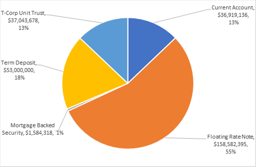
The ratio of market value compared to face
value of various debt securities is shown in the table below.
|
Asset
Class
|
Jul-20
|
Jun-20
|
|
Senior
Debts (FRN's ,TCD's & FRB)*
|
101.20%
|
100.75%
|
|
MBS
(Reverse Mortgage Backed Securities)
|
62.07%
|
62.11%
|
|
T-Corp
Unit Trusts
|
102.90%
|
102.81%
|
*Definition of terms
· Transferrable Certificate of Deposit (TCD)
- security issued with the same characteristics as a Term Deposit however it
can be sold back (transferred) in to the market prior to maturity. A floating
TCD pays a coupon linked to a variable benchmark (90 days BBSW).
· Fixed Rate Bond (FRB) – returns Fixed
Coupon (interest) Rate and is tradeable before maturity.
The economic environment globally, including
Australia, suffered significantly from the start of the COVID-19 pandemic in
March. The market value of Council’s investment in FRN’s has since
improved. Council has sufficient funds in its current account and has no plans
at this stage to sell off any of its FRN’s to meet its short-term
cashflow requirements.
Council is fully compliant with the requirements of
the Ministerial Investment Order including the grandfathering provisions. The
grandfathering provisions state that Council may continue to hold to maturity,
redeem or sell investments that comply with previous Ministerial Investment
Orders. Any new investments must comply with the most recent Order. Council
continues to closely monitor the investments in its portfolio to ensure
continued compliance and minimal exposure to risk.
Council is committed to NSW TCorp’s balanced
investment framework and held 19.51% of its portfolio in ADI’s rated BBB
and below.
Emerald – Mortgaged Backed Securities
Council’s new investment advisor, Amicus
Advisory, was asked on appointment to review Council’s investments in
“grandfathered” mortgage backed securities. Amicus has completed
its review and recommends Council continue to hold its investments in the
“Class A” and both “Class C” securities given current
poor market pricing. Notwithstanding this recommendation, Amicus has assessed
both “Class C” securities are likely to eventually default.
However, Council will continue to receive interest up until default which is
likely many years away. Fitch Rating Agency has decided to withdraw its rating
on mortgage backed securities and as a result, Council investments in these
securities are now classed non-rated.
Portfolio Maturity Profile
The table below shows the percentage of funds invested
at different durations to maturity.
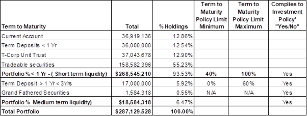
Market Value
by Issuer and Institution Policy limit as per Investment Policy
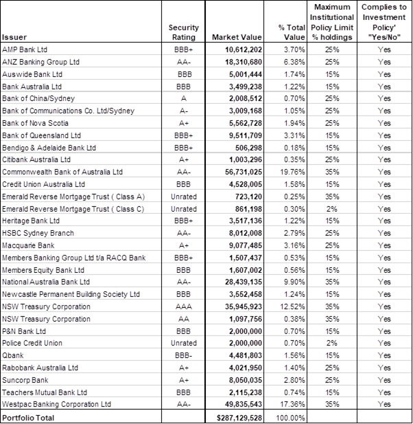
Overall Portfolio Credit Framework compliance to Investment Policy
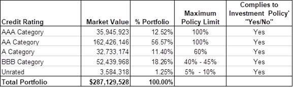
Portfolio
performance against relevant market benchmark.
Council’s Investment Policy prescribes the
AusBond Bank Bill Index (ABBI) as a benchmark to measure return on cash and
fixed interest securities. The ABBI represents the average daily yield of a
parcel of bank bills. Historically there has been a positive correlation
between changes in the cash rate and the resulting impact on the ABBI
benchmark.
The portfolio yield to 31st July 2020 exceeded the AusBond Bank Bill index by 125 basis
points (1.98% against 0.73%)
Council portfolio continues to perform at above
benchmark rates despite ongoing margin contraction and significantly lower
market term deposit yields. Comparative yields for the previous months are
charted below:
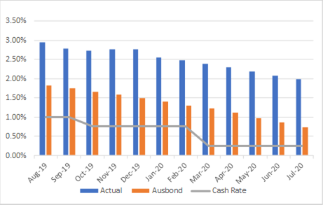
Performance
of Portfolio Returns against Budget
Council’s investment income for July 2020 is
lower than the original budget by $166k.
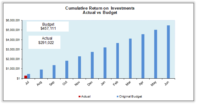
Investment
Portfolio at a Glance
|
Portfolio
Performance
|
![MCWB01114_0000[1]](CO_20200826_AGN_413_AT_files/image057.png)
|
The portfolio
yield to 31st
July 2020 exceeded the
AusBond Bank Bill index by 125 basis points (1.98% against 0.73%).
|
|
Annual Income
vs. Budget
|
|
Council’s investment interest income is lower
than the original budget by $166k as at 31st July 2020 and will be closely monitored.
|
Investment
Policy Compliance
|
Legislative Requirements
|
|
Fully Compliant
|
|
Portfolio Credit Rating Limit
|
|
Fully Compliant
|
|
Institutional Exposure Limits
|
|
Fully Compliant
|
|
Overall Portfolio Credit Limits
|
|
Fully Compliant
|
|
Term to Maturity Limits
|
|
Fully Compliant
|
Economic Outlook – Reserve Bank of Australia
The Reserve Bank has left the official cash rate on hold at
0.25 per cent in its meeting on 4th August 2020.The current 0.25 per
cent cash rate is at a historically
low level and impacts returns on investment.
Certificate of Responsible Accounting Officer
The Chief Financial Officer, as Responsible
Accounting Officer, certifies that the investments listed in the attached
report have been made in accordance with section 625 of the Local Government
Act 1993, clause 212 of the Local Government (General) Regulation 2005
and Council’s Investment Policy at the time of their placement. The
previous investments are covered by the grandfathering clauses of the current
investment guidelines issued by the Minister for Local Government.
Independent verification by Head of Audit, Risk and
Improvement (HARI)
Council had previously requested an on-going
independent review of its investment portfolio by the Audit Risk and
Improvement Committee (ARIC) or its representative under delegated authority.
At its meeting on 29th July 2020, Council resolved to discontinue
this requirement. NSW Audit Office, as part of their annual audit procedure
will obtain confirmation from respective financial institutions and validate
Councils investments.
|
Economic
|
Council’s investment interest income is lower
than the original budget by $166k as at 31st July 2020 and will be closely monitored.
|
|
Environment
|
There are no environmental and
sustainability considerations.
|
Social
|
There are no social and cultural considerations.
|
Civic
Leadership
|
There are no civic leadership and
governance considerations.
|
|
Legislative
|
Council is fully compliant with the
requirements of the Local Government Act 1993 – Investment Order
(authorized investments) and with reporting requirements under clause 212 of
the Local Government (General) Regulation 2005.
|
|
Risk
|
The capital value and return on
investment is subject to market risks. Investment limits prescribed in
Council’s policy framework is aimed to mitigate these risks.
|
1. Investment
Portfolio - July 2020
|
0
|
|
CORP
01
|
Investment
Report July 2020
|
|
Attachment
1
|
Investment
Portfolio - July 2020
|
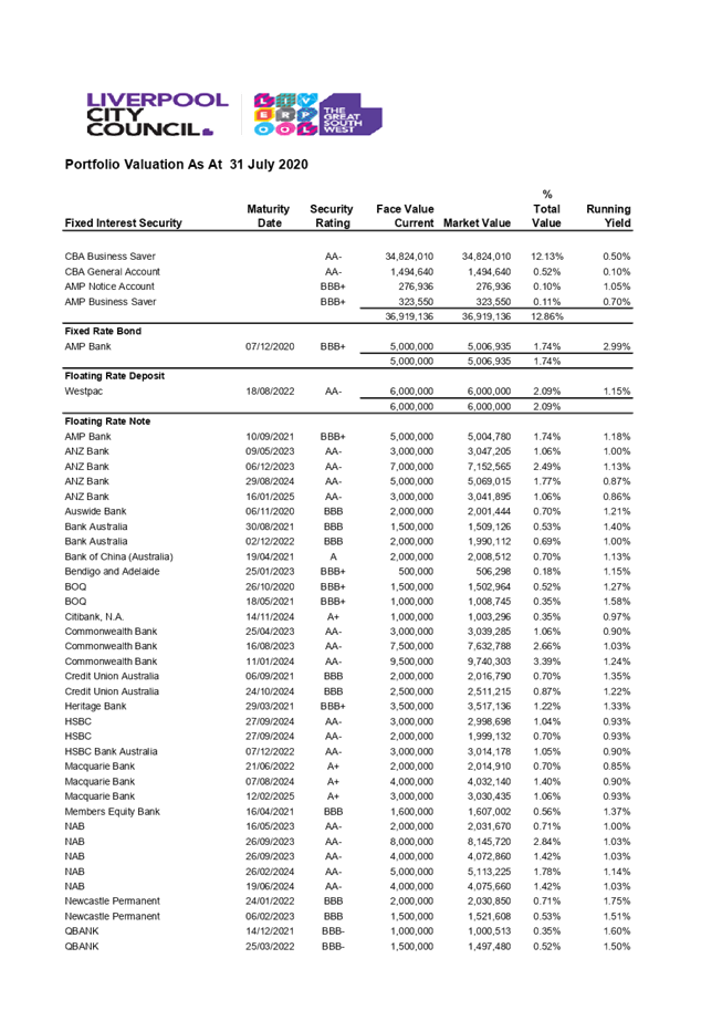
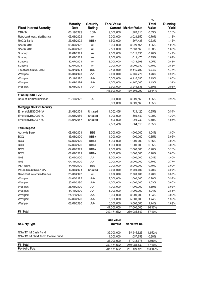
Ordinary Meeting
26 August 2020
|
CTTE 01
|
Minutes of the Environment Advisory
Committee held on 22 June 2020
|
|
Strategic
Direction
|
Strengthening
and Protecting our Environment
Develop, and
advocate for, plans that support safe and friendly communities
|
|
File Ref
|
191798.2020
|
|
Report By
|
Michael
Zengovski - Manager City Environment
|
|
Approved
By
|
Raj Autar -
Director City Infrastructure and Environment
|
This report is tabled in order to present
the Minutes of the Environment
Advisory Committee
Meeting held on 22 June 2020.
|
That Council receives and
notes the Minutes of the Environment
Advisory Committee Meeting held on 22 June
2020.
|
The Minutes of the Environment Advisory Committee held on 22 June 2020 are
attached for the information of Council.
The Minutes identify a number
of actions that require Council staff to undertake, none of which will have any
financial impact on Council.
|
Economic
|
Enhance the environmental performance of buildings and homes.
|
|
Environment
|
Minimise household and commercial waste.
Manage the environmental health of waterways.
Manage air, water, noise and chemical pollution.
Retain viable opportunities for local food production while managing
land use to meet urban growth.
Enhance the environmental performance of buildings and homes.
Protect, enhance and maintain areas of endangered ecological
communities and high quality bushland as part of an attractive mix of land
uses.
Raise community awareness and support action in relation to
environmental issues.
|
Social
|
Raise awareness in the community about the available services and
facilities.
Preserve and maintain heritage, both landscape and cultural as urban
development takes place.
Support community organisations, groups and volunteers to deliver
coordinated services to the community.
|
Civic
Leadership
|
Act as an environmental leader in the community.
Foster neighbourhood pride and a sense of responsibility.
Facilitate the development of community leaders.
Encourage the community to engage in Council initiatives and actions.
Provide information about Council’s services, roles and decision
making processes.
|
|
Legislative
|
There are no legislative considerations relating to
this report.
|
|
Risk
|
There is no risk associated with this
report.
|
1. Minutes
of the Enviroment Advisory Committee Meeting - 22 June 2020
|
0
|
|
CTTE
01
|
Minutes
of the Environment Advisory Committee held on 22 June 2020
|
|
Attachment
1
|
Minutes
of the Enviroment Advisory Committee Meeting - 22 June 2020
|
Ordinary Meeting
26 August 2020
|
CTTE 02
|
Minutes of the Liverpool Pedestrian,
Active Transport and Traffic Committee meeting held on 22 July 2020
|
|
Strategic
Direction
|
Generating
Opportunity
Advocate
for, and develop, transport networks to create an accessible city
|
|
File Ref
|
207606.2020
|
|
Report By
|
Charles
Wiafe - Service Manager Traffic and Transport
|
|
Approved
By
|
David Smith
- Acting Director City Economy and Growth
|
This
report presents the recommendations of
the Liverpool Pedestrian, Active Transport and Traffic Committee meeting held
on 22 July 2020. At the meeting, the Committee considered eight (8) agenda
items, four (4) technical discussion items and nine (9) general business items.
A
copy of the meeting minutes, incorporating the Committee’s
recommendations on the agenda items is included as Attachment 1.
|
That Council adopts the following recommendations of
the Committee:
Item
1 - Kurrajong Road and
Wingham Road roundabout, Carnes Hill – Proposed raised threshold across
the eastbound approach.
· Council approves the proposed raised threshold for eastbound
traffic on the approach to Kurrajong Road/William Buckley Drive/ Wingham Road
roundabout.
· The project is to include tree planting
and landscaping in the central island.
Item
2 - Sandringham Drive, Cecil
Hills – Reconfiguration to permit additional on-street parking.
· Council approves the proposed signs and line marking
associated with localised road widening of the section of Sandringham Drive
in front of Cecil Hills Heritage Farm.
Item
3 - Seventeenth Avenue,
Austral – Proposed children’s crossing and associated signs and
line marking Scheme.
· Council approves the proposed children’s crossing and
associated signs and line marking scheme.
Item
4 - Flynn Avenue, Middleton
Grange – Proposed raised threshold.
· Council approves installation of a raised
threshold in the form of asphaltic concrete as a temporary facility until
such a time that the road section is reconstructed.
Item
5 - Reilly Street and Gill
Avenue, Liverpool – Proposed roundabout upgrade.
· Council approves the proposed raised
thresholds and associated signs and line marking scheme.
· The project is to investigate the
inclusion of landscaping in the central island.
Item
6 - Soldiers Parade,
Edmondson Park – Additional on-street parking.
· Council approves on-street kerbside parking with associated
signs and line marking along the western side of Soldiers Parade.
· Council approves installation of a raised
median island as part of the kerbside parking works.
Item
7 - Heathcote Road/Bardia
Parade/Walder Road intersection upgrade, Holsworthy - Signs and line marking
Scheme.
· Council approves the signs and line marking
along Bardia Parade and Walder Road as well as a central median island on the
Walder Road approach to Heathcote Road.
Item 8 - Kelly Street, Austral – Proposed roundabout and signs and line
marking scheme.
· Council approves the proposed traffic facilities including the
roundabout and associated signs and line marking scheme.
· The project is to investigate tree
planting and landscaping in the central island.
Item
9 - Items approved under delegated authority
· Council notes the traffic facilities
approved under delegated authority between 20 May 2020 and 22 July 2020.
|
This
report presents the recommendations of
the Liverpool Pedestrian, Active Transport and Traffic Committee meeting held
on 22 July 2020. At the meeting, the Committee considered eight (8) agenda
items, four (4) technical discussion items and nine (9) general business items.
A
copy of the meeting minutes, incorporating the Committee’s
recommendations on the agenda items and actions in response to the technical
discussion and general business items is included as Attachment 1. It is
recommended that Council adopts the Committee’s recommendations on the
agenda items as outlined above.
Three Technical Discussion and nine General Business
items were considered, and the recommended actions are as follows:
Technical Discussion
Items
TD1 - Governor Macquarie Drive, Chipping Norton
– Reconfiguration and upgrade to a four-lane road.
Council has
received funding to extend the existing right lane from Governor Macquarie
Drive (GMD) into Newbridge Road and rehabilitate the section of GMD between
Newbridge Road and Alfred Road.
The project
includes extension of the existing right turn from Governor Macquarie Drive
into Newbridge Road from 80 to 180 metres in order to address queuing during
the morning peak hours. In consultation with TfNSW, it is proposed to restrict
turning movements at the GMD/ Balanada Avenue intersection to left in left out.
The Transdev representative has advised that a revised bus route along Governor
Macquarie Drive with a U-turn will be used and hence the left-in left-out
configuration would not affect their school bus service. Consultation will be
carried out with the local residents during detailed design and prior to
construction.
TD2 - Overview of Road Safety Program 2019/2020.
This is an
overview of the major projects conducted by the Road Safety Program over the
past financial year. A report on the overview is attached in the booklet.
Council’s
road safety officers provided an update on the local government road safety
program and advised as follows:
· Six child restraint checking events were conducted
by Council in the 2019/20 financial year. It was found that 85% of the
restraints were fitted incorrectly.
It was discussed and agreed that parents may be given the opportunity to
book online.
· A slowdown campaign initiative was carried
out along seven local streets. This aims to increase driver awareness on the
need to slow down along local streets.
· TfNSW provides funding for workshops titled
“Helping Learner Drivers Become Safer Drivers” It aims to provide
parents and carers further understanding about driving experiences for younger
inexperienced drivers. It informs and educates supervisors of the use of the
learner driver logbook and license conditions.
· School Road Safety - Council is working closely with
schools in the LGA on road safety initiatives. Social media and digital flyer
promotions are being made for community education.
TD3 - Anzac Road and Delfin Drive, Wattle
Grove – Traffic Management Changes.
Council has
received representations to reduce traffic delays along the section of Delfin
Drive fronting Wattle Grove Lake. This road section has two bus stops on both
sides of the road and a pedestrian refuge.
The concern
is that buses at the bus stops delays through traffic. A revised configuration
will be submitted to the Police and TfNSW for approval under delegated
authority.
General Business Items
GB1 - Hume
Highway and DeMeyrick Avenue – Concern about safe pedestrian movements,
and request for speed hump, parking restriction and a marked pedestrian
crossing.
Council has
received representations concerning safe pedestrian movements with a request
for a speed hump, parking restrictions and a marked pedestrian crossing at the
above intersection. An assessment will be carried out to determine the need for
a speed hump, parking restrictions and a pedestrian crossing and if required,
approval will be sought under delegated authority.
GB2 -
Ernest Avenue, Chipping Norton in front of Market Plaza – Illegal parking
along the western side
This road
section is currently signposted as “No Stopping” and a bus zone.
Hence, the kerbside parking is illegal parking and Council enforcement officers
will be requested to patrol and enforce the existing parking restriction.
GB3 -
Wonga Road and Compton Avenue intersection – Request for traffic calming
devices
The Federal
Member for Werriwa has made a representation for installation of a raised
pedestrian crossing and speed hump close to the intersection of Wonga Road and
Compton Avenue.
Investigation
will be carried out and if required, approval will be sought either under
delegated authority or presented to the next committee meeting.
GB4 - Projects to be nominated under the Federal
Blackspot Program
As part of the Federal Blackspot Program, TfNSW has
requested Council to nominate road sections (including intersections that meet
the warrant for submission under the program). A list of projects as shown in
the minutes was discussed and noted.
GB5 - Line Markings at Talana Hill Drive, Edmondson
Park
Councils maintenance team has been requested to carry
out the line marking during the month.
GB6 - Cowpasture Road, Hoxton Park Road and Fifteenth
Avenue intersection
Clr Harle expressed concern about noisy motorbike
movements along the section of Cowpasture Road close to its intersection with
Hoxton Park Road/Fifteenth Avenue and requested that the Liverpool Local Area
Command patrol the location.
The Police representative agreed to the request and
advised that the road section will be included in their patrol and
enforcement.
GB7 -
Wattle Grove and Delfin Drive
Clr Rhodes
expressed concern about antisocial driving behavior at this location due to
speeding and traffic noise. She requested the Police include the location in
their patrol and enforcement. The Police representative agreed to this request.
GB8 -
Potholes at 10 and 22 Harvey Avenue
Clr Rhodes
queried whether potholes have been repaired at this location. A response will
be sent to Clr Rhodes.
GB9 -
Moorebank Avenue, near Church Road accident
The Police
representative advised that there has been a recent fatal crash at the
intersection and the Police is carrying out investigation into the cause of the
crash. It was discussed and agreed that TfNSW would also investigate and if
required implement possible signs and line marking.
Budget
impact of matters arising from the minutes
|
Item
|
Description
|
Funding, Indicative Cost and Timing
|
|
1
|
Kurrajong Road and Wingham Road
Roundabout, Carnes Hill – Proposed Raised Threshold Across the
Eastbound Approach.
|
Council’s minor traffic facilities
project
Indicative Cost - $65,000.
Timing – March 2021.
|
|
2
|
Sandringham Drive, Cecil Hills –
Reconfiguration to Permit Additional On-Street Parking.
|
Council’s minor traffic facilities
project
Indicative Cost - $50,000.
Timing – March 2021.
|
|
3
|
Seventeenth Avenue, Austral –
Proposed Children’s Crossing and associated Signs and Line Marking
Scheme.
|
Developer
Timing – In accordance with
development consent requirement
|
|
4
|
Flynn Avenue, Middleton Grange –
Proposed Raised Threshold.
|
Council’s minor traffic facilities
project
Indicative Cost - $30,000.
Timing – February 2021.
|
|
5
|
Reilly Street and Gill Avenue, Liverpool
– Proposed roundabout upgrade.
|
Federal Blackspot Program#
Indicative Cost - $100,000
Timing - March 2021
|
|
6
|
Soldiers Parade, Edmondson Park –
Additional On-Street Parking.
|
Council’s minor traffic facilities
project
Indicative Cost - $10,000.
Timing – November 2020.
|
|
7
|
Heathcote Road/Bardia Parade/Walder Road,
Holsworthy – Intersection upgrade and Signs and Line Marking Scheme.
|
Federal Government Funding under Western
Sydney Infrastructure Program (local roads package)
Indicative Cost - $1.1m.
Timing – May 2021.
|
|
8
|
Kelly Street, Austral – Proposed
Roundabout and Signs and Line Marking Scheme.
|
Developer
Timing – In accordance with
development consent requirement.
|
|
9
|
- Items Approved Under Delegated
Authority
|
RMS block grant funding#
Indicative Cost - $10,000.
Timing – October 2020.
|
# RMS block grant
funding has no financial implication on Council
|
Economic
|
Provide efficient parking for the City Centre.
Deliver a high-quality local road system
including provision and maintenance of infrastructure and management of
traffic issues.
|
|
Environment
|
Promote an integrated and user-friendly public transport service.
Support the delivery of a range of transport
options.
|
Social
|
Support access and services for people with a disability.
Improve road and pedestrian safety.
|
Civic
Leadership
|
Actively advocate for federal and state government
support, funding and services.
|
|
Legislative
|
Provide efficient parking for the City Centre.
Deliver a high-quality local road system
including provision and maintenance of infrastructure and management of
traffic issues.
|
|
Risk
|
The risk is considered Low.
The risk is considered within
Council’s risk appetite.
|
1. Minutes
- Liverpool Pedestrian, Active Transport and Traffic Committee Meeting - 22
July 2020
|
0
|
|
CTTE
02
|
Minutes
of the Liverpool Pedestrian, Active Transport and Traffic Committee meeting
held on 22 July 2020
|
|
Attachment
1
|
Minutes
- Liverpool Pedestrian, Active Transport and Traffic Committee Meeting - 22
July 2020
|
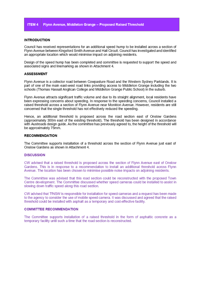
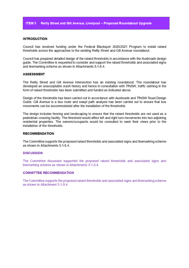
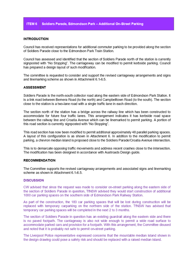

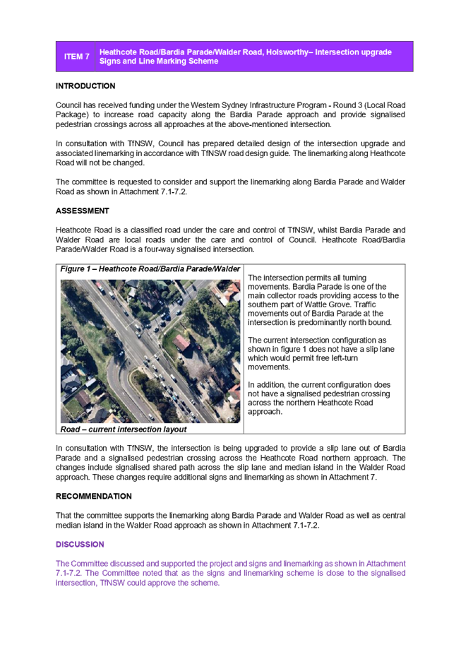

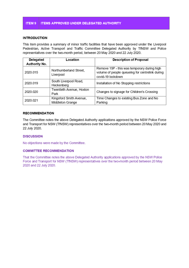
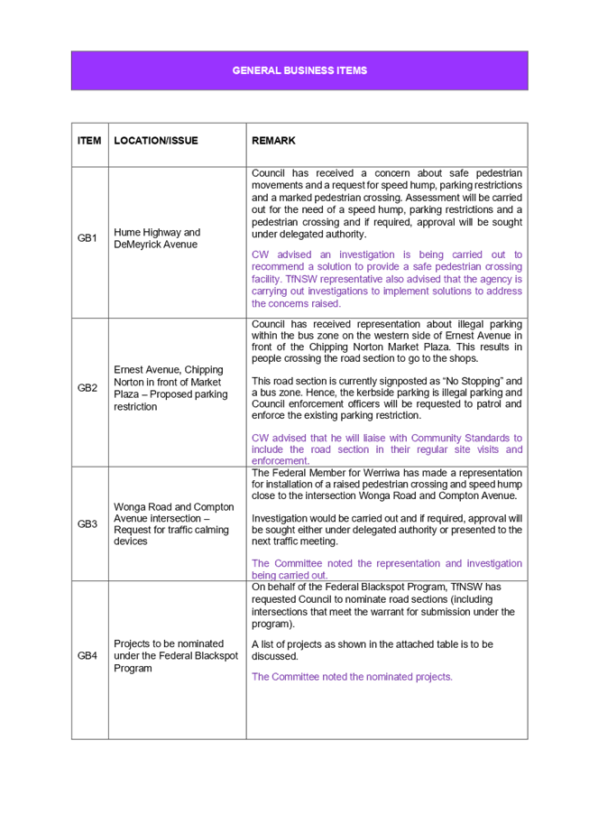
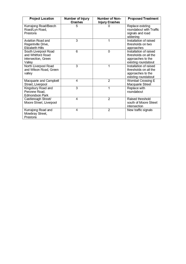

Ordinary Meeting
26 August 2020
|
QWN 01
|
Question with Notice - Clr Hagarty -
Appeal Powers Against Land and Environment Court Decisions
|
|
Strategic
Direction
|
Leading
through Collaboration
Strive for
best practice in all Council processes
|
|
File Ref
|
190647.2020
|
Please address the following:
1. What appeal powers do Council (or the
public) have when an applicant’s appeal of previously refused DA is
upheld by the Land and Environment Court?
Response
What is the applicant’s right of
appeal against refusal of a DA?
Where the Council is the consent authority for
development and decides to refuse consent to a development application
(‘DA’), the applicant has the right to appeal to the Land and
Environment Court (‘Court’) within 6 months of the decision.
When is the Council a party to an appeal
against refusal of a DA?
The Council is the consent authority
responsible for determining the DA, and hence a party to the appeal to the
Court, where the decision to refuse consent was made by the local planning
panel/regional planning panel on the Council’s behalf or by an officer of
the Council under delegated authority from the Council.
Can members of the public be a party to an
appeal against refusal of a DA?
Only the applicant and the Council are parties
to the appeal proceedings, unless the Court orders that another person is
joined as a party, which is uncommon.
Members of the public have no right of appeal
to the Court against a decision by the Council to refuse consent to a DA.
Can an objector appeal against refusal of a
DA that is designated development?
No. An objector can only appeal a decision of a
consent authority to grant consent to designated development.
If the Court grants consent to designated
development, ordinarily, an objector cannot appeal the Court’s decision.
In very limited circumstances, an objector can
bring judicial review proceedings to review a decision by the Court to grant
consent to a designated development.
On what basis is an appeal against refusal of a DA dealt with by the Land and
Environment Court?
An appeal against the refusal of a DA is heard
and determined by the Court on the planning merits of the DA.
The appeal does not involve a review of the
Council’s decision but instead involves the making of an entirely new
decision.
The appeal is ordinarily heard and determined
by a commissioner of the Court rather than a judge.
Who can appeal the Land and Environment
Court’s determination of an appeal against the refusal of a DA & on
what basis?
Ordinarily, only parties to the appeal have a
right to appeal the Court’s decision in an appeal against refusal of a
DA. Therefore, ordinarily only the applicant and the Council will have appeal
rights against the Court’s decision.
Where an appeal against the refusal of a DA is
heard and determined by a commissioner of the Court, the Council has a right to
appeal to a judge of the Court against an order or decision made by the
Commissioner but only on a question of law. The appeal must be brought within
28 days. The Council may bring a further appeal to the Supreme Court against
the decision of the judge of the Court, but only on a question of law, and the
leave of the Supreme Court is required for it to do so. This further appeal
process must be commenced within 28 days.
Where the Council is a party to an appeal
against the refusal of a DA that is heard and determined by a judge of the
Court, the Council may appeal to the Supreme Court against the decision of the
judge on a question of law. The appeal process must be commenced within 28
days.
What is a question of law?
In general terms, a question of law is one that
must be answered by applying relevant legal principles to interpretation of the
law rather than by applying facts and evidence. Thus, in an appeal involving a
question of law, the appellate body does not review the merits of the decision
the subject of the appeal but rather the legal basis on which the decision was
made.
Nil
Ordinary Meeting
26 August 2020
|
QWN 02
|
Question with Notice - Clr Kaliyanda -
Processing of Organic Waste in the Liverpool LGA
|
|
Strategic
Direction
|
Strengthening
and Protecting our Environment
Manage the
community’s disposal of rubbish
|
|
File Ref
|
190649.2020
|
Please address the following:
1. How much of waste collected in the
Liverpool LGA is organic waste? How much of this is organic food waste?
2. How much organic waste in the Liverpool LGA
actually ends up in landfill?
3. Do we currently have any policies or
strategies in place to divert organic food waste from landfill?
4. Are there collective procurement contracts
or similar arrangements for organic waste in NSW?
Response
1. How much
of waste collected in the Liverpool LGA is organic waste? How much of this is
organic food waste?
In
2019/2020 there was 16,736.69 tonnes of organic garden waste collected through
the Council’s kerbside garden waste bin. From a recent
audit, 48% of the red bin waste is food
material. This means that in 2019/2020 there was 24,860.75 tonnes of food waste
in the red general waste bin.
2. How much
organic waste in the Liverpool LGA actually ends up in landfill?
All waste in the red general waste bin currently goes
to landfill. The waste in the organics garden bin is processed into soil
products.


3. Do we currently
have any policies or strategies in place to divert organic food waste from
landfill?
The NSW government is currently working on a 20 year
Waste Strategy which is due to be released in late 2021. Council has undertaken
research into a local strategy and is waiting for the release of the state
strategy to finalise our strategy. This will give council the ability to align
our strategy with the state government targets and goals and respond
accordingly.
The Domestic Waste Collections tender which is
currently being evaluated will have provisions for future changes in bin
configurations and processing locations. This will give council the opportunity
to adapt to any future opportunities such as Food Organics Garden Organics
(FOGO), energy from waste, or other technologies.
Council has also placed an application for a grant
under the Local Government Transition Fund. This grant will commission a
feasibility and transition strategy around FOGO. Council will also be
supporting the separate WSROC submission around food waste disposal option in
multi-unit dwellings.
Council does encourage residents to divert food waste
from there general waste bins by offering residents a $50 rebate off a compost
bin or worm farm reciprocal. Council also offers community workshops on worm
farming and composting. Our waste primary school and preschool program address
worm farming and composting.
4. Are there
collective procurement contracts or similar arrangements for organic waste in
NSW?
Liverpool is working with Camden, Campbelltown, Liverpool, Wollondilly and
Wingecarribee to collectively tender and secure the provision of waste
processing and disposal services for:
·
General Waste
·
Recycling
·
Organics
·
Bulky Waste
The project aims to ensure Councils have collective
bargaining power to attract market investment in technology and infrastructure
to service the South West Sydney region. Through this partnership, the Councils
will also gain access to a dedicated facility, secure disposal and price
certainty for the life of the contract.
Nil
Ordinary Meeting
26 August 2020
|
QWN 03
|
Question with Notice - Clr Hagarty -
Western Sydney Parklands Trust
|
|
Strategic
Direction
|
Creating
Connection
Create a
dynamic, inclusive environment, including programs to support healthy living
|
|
File Ref
|
216410.2020
|
Background
In July the Berejiklian
government announced it will fold the Centennial Park and Moore Park,
Parramatta Park and the Western Sydney Parklands trusts into a new super trust.
This move would appear to run
counter to Western Sydney Parklands' ethos of being Western Sydney's backyard
and the Greater Sydney Commissions' Metropolis of Three Cities Plan.
While Centennial, Moore &
Parramatta Parks are established open space which have existed for well over a
century, Western Sydney Parklands is still being developed.
The social, economic and
cultural needs of Western Sydney must be determined by the people of Western
Sydney.
With this latest move and the
impact of COVID-19 on the NSW budget, Liverpool needs reassurance that plans
for Western Sydney Parklands are still on track.
Please address
the following:
1. Are plans for the development
of the Liverpool section of Western Sydney Parklands still on track?
2. Will these plans change with
the Western Sydney Parklands Trust being rolled into a super parklands trust?
3. How will the unique needs and
priorities of Western Sydney and Western Sydney Parklands be catered for in
this new structure?
4. What structure will the board
of the new trust take?
5. How many board members on the
new trust will be from Western Sydney?
6. Will a board quota be set to
ensure sufficient representation from Western Sydney?
A response to
these questions will be provided in the 30 September 2020 Council meeting
business papers.
Nil
Ordinary Meeting
26 August 2020
|
QWN 04
|
Question with Notice - Clr Rhodes -
Georges River Bank Stabilisation
|
|
Strategic
Direction
|
Strengthening
and Protecting our Environment
Protect and
enhance bushland, rivers and the visual landscape
|
|
File Ref
|
218196.2020
|
Please
address the following:
Can Council provide a report on the recent collapse of
the Eastern bank of the Georges River opposite the Council dog park and
bordering the Moorebank Intermodal.
1. What is being done to stabilise the banks
of the Georges River at this particular site and others along the Georges
River?
2. Who is responsible to stabilise the bank of the
Georges River?
3. When will stabilisation of the Georges River bank be
done?
4. Explain the Georges Riverkeeper’s involvement vs
conditions imposed on development applications to stabilise the Georges River
banks?
Recent collapse of the Georges River bank along side
the Moorebank Intermodal site and opposite the Council dog park was disturbing
to say the least.
A large chunk of the bank that borders the Moorebank
Intermodal Development site recently fell into the River.
When the ground is left bare
by human activities including clearing, building (and related activities) and
vehicle use such as 4WD's and trail bikes the soil is easily washed away when
it rains. Examples of this can be seen between Sandy Point and Alfords Point as
sediment from the ridges washes into Mill Creek and then into the Georges
River. This erosion removes the fertile topsoil and the soil that is washed
into waterways can contain plant nutrients, minerals, organic matter and seeds.
It can also contain pesticides and toxic heavy metals.
When soil,
sand, dust, cement, paint and building debris reach the waterways, they can:
· increase the risk of
flooding;
· block drains;
· spread weeds to bushland;
· result in algal blooms;
· cause health problems for
swimmers; and
· smother and suffocate water
plants and animals and impact on their ability to reproduce.
The size of the erosion that fell into the Georges
River in the one event is of particular concern and needs to be addressed.
A response to these questions
will be provided in the September 2020 Council meeting business papers.
Nil
Ordinary Meeting
26 August 2020
|
QWN 05
|
Question with Notice - Clr Kaliyanda -
Wattle Grove Lake
|
|
Strategic
Direction
|
Strengthening
and Protecting our Environment
Protect and
enhance bushland, rivers and the visual landscape
|
|
File Ref
|
219555.2020
|
Please address the following:
1. What measures have been undertaken to
improve the water quality at Wattle Grove Lake? What measures have been found
to be successful?
2. What is the underlying issue with the water
quality at Wattle Grove Lake?
3. What measures are still being undertaken,
or are currently planned, to improve the water quality at Wattle Grove Lake?
4. How has Council sought partnerships and
worked with other organisations in order to address this issue?
A response to these questions
will be provided in the September 2020 Council meeting business papers.
Nil
Ordinary Meeting
26 August 2020
|
NOM 01
|
Parking on Verges and Nature Strips
|
|
Strategic
Direction
|
Leading
through Collaboration
Strive for
best practice in all Council processes
|
|
File Ref
|
216306.2020
|
|
Author
|
Nathan
Hagarty - Councillor
|
Parking on verges and nature strips can
attract fines. Alternatively, parking in some of Liverpool's smaller streets
blocks the access of emergency services vehicles and garbage trucks
Previously, Council has passed initiatives
to deliver more on street parking and allow second driveways. In April, Council
sought to bring some common sense to the issue of parking on verges and nature
strips. However, there still appears to be some confusion, with a number of
residents still being fined for parking on a verge or nature strip.
It is evident that a clear and easily
understood policy needs to be developed for the benefit of residents,
compliance staff and Councillors.
|
That Council:
1. Update
relevant policies and procedures to give clear and unambiguous guidance
setting out when a fine will or won't be issued for parking on a verge or
nature strip, including pictures and diagrams;
2. Bring
back any updated policies to the October meeting of Council; and
3. Run an awareness campaign on
this clear and unambiguous guidance through the District Forums, social and
traditional media and other suitable forums.
|
ACTING CHIEF
EXECUTIVE OFFICER’S COMMENT
The NSW Road Rules Regulation 197
specifies that – “A driver must not stop on a bicycle path,
footpath, shared path or dividing strip, or a nature strip adjacent to a length
of road in a built-up area”.
Council officers attend to complaints
about parking on nature strips. No proactive patrols are conducted. Once it is
established that illegal parking is occurring, residents of the street are sent
education letters advising them of the NSW Road Rules and advising them not to
park on the footpath or nature strip. If illegal parking continues and
complaints are received, fines are issued.
Transport for NSW (TfNSW) has published
technical guidelines on arrangements including paving road verges along narrow
streets to permit legal parking. A number of Councils are using recommendations
from the guidelines to provide indented parking bays along narrow roads.
At its meeting on 11 December 2019,
Council considered a report – EGROW06 “Guidelines for the
assessment of on-street parking along narrow streets” and resolved:
That
Council:
· Adopts the Guidelines for the Assessment and
Prioritisation of Parking along Narrow Streets;
· Notes that funding allocation for the provision
of on-street parking along narrow streets can be considered in the 2020/21 and future
years’ budgets; and
· Provides an education plan until the end of
February 2020 to residents parking on verges.
This financial year’s budget
includes a funding allocation of $200,000 and a list of streets that will be
prioritised for indented parking to be provided.
Council also resolved as part of its
COVID-19 response at its meeting on 16 April 2020 to:
“Direct the CEO to apply
discretion when issuing infringements, while protecting public health and
safety. In that regard, fines will only be issued in the following
circumstances:
· Parking in a “No
Stopping” and “No Parking” zones and in close proximity to an
intersection;
· Trucks parking in residential
areas in excess of one hour;
· Parking on nature strips where
it causes an obstruction to pedestrians and/or a blind spot for drivers exiting
their driveways;
· Environmental pollution
incidents; and
· Dog attacks
There was no
end date attached to this resolution. As a result of a further resolution of
Council from the meeting on 24 June 2020, Council resolved (for the purposes of
defining an end date of COVID related measures):
· Where a date is specified in the resolution
– then that date will continue to apply.
· Where no date is specified in the resolution and
the resolution is subject to the lifting of a restriction – then, for the
purpose of implementing the resolution, the date will be 1 July 2020. It
would be anticipated that at that point minimal restrictions would remain in
place affecting only some businesses. For example, on 16 April 2020 Council
resolved to waive all out-door dining fees from the date of restriction coming
into place until 2 months after these restrictions are lifted. The proposed
amendment would mean that out-door dining fees would be waived until 2 months
after 1 July 2020.
· Where a resolution is not subject to the lifting of a
restriction and the resolution requires Council to provide assistance for an
unspecified period – then, for the purpose of implementing the
resolution, the resolution will apply for the duration of the 2020/21
financial year, unless otherwise resolved by Council.
Based on the above resolution,
discretion is being applied as resolved by Council in issuing infringements
during the 2020/21 financial year.
A continuing education campaign can
be undertaken to remind residents of the NSW Road Rules.
Nil
Ordinary Meeting
26 August 2020
|
NOM 02
|
Register of Legal Proceedings
|
|
Strategic
Direction
|
Strengthening
and Protecting our Environment
Exercise
planning controls to create high-quality, inclusive urban environments
|
|
File Ref
|
218682.2020
|
|
Author
|
Nathan
Hagarty - Councillor
|
Carrying out non-permitted uses puts lives and
property at risk. It can also have a detrimental impact on the environment.
With the courts not sitting as frequently as they did
pre-COVID-19, compliance matters requiring legal action are taking longer to
resolve.
Despite numerous orders, some residents and businesses
are continuing to undertake these non-permitted uses while Council awaits a
legal outcome.
Unfortunately, this is creating the false perception
among some that Council is not carrying out its compliance duties efficiently
or effectively. This is certainly not the case.
Council needs to explore all means to stop this
illegal activity.
|
That Council:
1. Pending legal advice, set up a page on the Council
website that lists the current compliance action awaiting a legal outcome;
and
2. Post a link to this page on social media once a
month.
|
Nil
Ordinary Meeting
26 August 2020
|
NOM 03
|
Use of Data to Improve Energy
Efficiency and Reduce Pollution
|
|
Strategic
Direction
|
Strengthening
and Protecting our Environment
Encourage
sustainability, energy efficiency and the use of renewable energy
|
|
File Ref
|
219498.2020
|
|
Author
|
Charishma
Kaliyanda - Councillor
|
The
ClimateClever app enables users to measure and monitor electricity, gas and
water consumption. Developed by Curtin University, it provides users with an
action plan on how to be more efficient with their energy use, reducing
pollution and utility bills.
ClimateClever works in three simple steps:
·
Measure – Calculate and
track consumption, pollution and costs.
·
Audit – Understand how the
home or school consumes resources, and how this contributes to pollution and
utility costs.
·
Action – Create a custom
action plan to systematically reduce resource consumption, pollution and
utility bills.
A
growing number of local governments across Australia have partnered with
ClimateClever to offer residents, local schools and businesses a way to measure
their energy consumption, reduce pollution and save on their utility bills.
Some of the benefits for local governments include:
·
Enhance tree planting
across the LGA – to date, more than 85,000 trees have been planted across
Perth and regional WA under this scheme.
·
Adopt an easy, concrete
and measurable way to meet strategic goals – apps simplify the collection
and analysis of utility and usage data.
·
Build genuine community
engagement around sustainability – the ClimateClever program provides a
new and innovative way to up-skill a large and engaged audience of students,
teachers and school staff; households; and, soon, local businesses.
·
Fostering and
developing leadership in sustainability – helping to engage, educate and
up-skill students around these important issues.
·
Help our local schools,
households and businesses achieve savings on their utility bills
The
ClimateClever initiative already has a number of local government partners,
including the Cities of Albany, Canning, Stirling and Mosman Council.
With
Liverpool regularly having the worst air quality in the Sydney basin, we should
welcome initiatives that encourages schools, households and businesses to plant
more trees and reduce pollution .
A
standard partnership costs $850 + GST.
|
That Council:
1. Trial a standard partnership with the ClimateClever
initiative for 12 months;
2. Run a public awareness campaign to encourage take up
of the app among local schools, businesses and households; and
3. Report back in 12 months on the efficacy
of the app, in particular, its effectiveness in meeting the goals of
Council’s 10 year Community Strategic Plan.
|
Nil