Ordinary Meeting
25 November 2020
City Economy and Growth Report
|
EGROW 05
|
Planning proposal request to rezone
land and amend development standards in the Liverpool Local Environmental
Plan for land at Moore Point Bridges Road, Moorebank
|
|
Strategic
Direction
|
Generating
Opportunity
Meet the
challenges of Liverpool’s growing population
|
|
File Ref
|
297711.2020
|
|
Report By
|
David Smith
- Acting Director City Economy and Growth
|
|
Approved
By
|
David Smith
- Acting Director City Economy and Growth
|
|
Property
|
3 Bridges Road,
Moorebank (Lot 200, DP 1009044);
5 Bridges Road
(Lot 100, DP 775780);
6 Bridges Road
(Lot 10, DP 875626);
8 Bridges Road
(Lot 111, DP 1133744);
11 Bridges Road
(Lot 201, DP 1009044);
361 Newbridge
Road (Lot 101, DP 827141)
|
|
Owner
|
Coronation
Property Co Pty Ltd and Leamac Property Group
|
|
Applicant
|
Mecone
|
Council
received a request to prepare a planning proposal on behalf of Coronation
Property and Leamac Property Group (Attachment 1) for 32 hectares of
land in the precinct known as Georges River North, or Moore Point in Moorebank.
The planning proposal request seeks to rezone the site, amend development
standards, introduce additional permitted uses, and introduce site-specific
development controls to enable a mixed-use development on the site, which would
allow for approximately 12,200 dwellings and 249,364m² of commercial floor space over a
long-term period until 2051.
The
planning proposal request specifically seeks the following amendments to the
Liverpool Local Environmental Plan (LEP) 2008:
· Rezone the subject land from IN2 Light
Industrial to B4 Mixed Use, B6 Enterprise Corridor and RE1 Public Recreation;
· Increase the maximum floor space ratio to
4.2:1 and 3.5:1;
· Increase the maximum height of buildings
from 18m and 15m to RL 136 and RL 108; and
· Introduce Division 1A into the LEP to
provide site-specific development controls for the site including design
excellence, sun access and requirements for the preparation of a development
control plan. This Division also seeks an amendment to the Key Sites Map such
that Clause 7.22(4) of the LEP applies to the site, which would allow
residential development within 50m of a classified road within the B6 zone, as
long as it is not within 8m of the classified road.
The planning proposal request also includes an Urban
Design Study, which includes a structure plan for the entire ~38.5-hectare
Moore Point precinct, as well as studies for the entire precinct.
The Council officer’s planning assessment report
to the Local Planning Panel is included in Attachment 2. The report
concludes that the proposal demonstrates strategic and site-specific merit. It
is noted that the finalisation of flooding and traffic studies is required and
will be completed post a Gateway determination. The report recommends that a
planning proposal be submitted to the Department of Planning, Industry and
Environment (DPIE) for a Gateway determination.
Advice was sought from the Liverpool Local Planning
Panel (LPP) at its meeting on 26 October 2020 in
accordance with the Local Planning Panel Direction – Planning
Proposals dated 23 February 2018. The panel concluded that the proposal had
strategic merit. A majority of the panel (3-1) agreed that the proposal had
site-specific merit, with a dissenting opinion stating that there was not
enough information to determine whether there was site-specific merit at this
point in time. The panel advice is that it is appropriate for the planning
proposal to proceed to a Gateway determination, with all issues raised in the
majority and dissenting opinion to be appropriately addressed at the post
Gateway stage. The advice of the LPP is provided at Attachment 3.
It is recommended that Council note the advice of the
LPP, support in principle the planning proposal request with the recommended
amendments and submit the proposal to DPIE seeking a Gateway determination.
|
That Council:
1. Notes the advice of the Liverpool Local
Planning Panel;
2. Endorses in principle the
planning proposal request with the following amendments:
a) an additional 1.5 hectares of
open space marked as ‘Open Space Investigation’ adjacent to Haigh
Park;
b) a minimum 40m RE1 –
Public Recreation zone is provided along Lake Moore;
3. Endorses the Urban Design
Study and Structure Plan for the George’s River North precinct, with
the above amendments, to guide the assessment of future planning proposals in
this area;
4. Notes that further detailed
studies, including site contamination, acoustic, flood, flood evacuation and
transport impact assessment will be completed post Gateway determination;
5. Notes the offer from the
proponent to enter into a Voluntary Planning Agreement and/or the preparation
of a Local Infrastructure Contributions Plan to ensure there is appropriate
funding for local infrastructure to support development in the precinct;
6. Delegates to the A/CEO
authority to negotiate a planning agreement with the proponent, agree the
terms of offer with the proponent and report back to Council the details of
any planning agreement, consistent with Council’s Planning Agreements
Policy;
7. Delegates to the A/CEO authority to
prepare the formal planning proposal including any typographical or other
editing amendments if required;
8. Forwards a planning proposal
to the Department of Planning, Industry and Environment, pursuant to Section
3.34 of the Environmental Planning and Assessment Act 1979, seeking a
Gateway determination with a recommendation that completion of relevant studies
be included as a condition of any Gateway determination and that the
Department play an active role in the planning process given the strategic
significance of this proposal to Liverpool and Greater Sydney; and
9. Receives a further report on
the outcomes of public exhibition and community consultation.
|
Background
Council received this planning proposal request on 15
April 2020. The planning proposal request replaced the previous planning
proposal request lodged in 2015, and all other previous site-specific planning
proposal requests in this area, lodged by the proponents, were withdrawn.
Council had previously resolved to defer consideration
of these planning proposal requests while the draft Georges River Precinct Plan
was developed in 2016, and again until the release of the Liverpool
Collaboration Area Place Strategy.
Following the adoption of the Liverpool Collaboration
Area Place Strategy by the Greater Sydney Commission in September 2018, Council
indicated to landowners in Moore Point that it was prepared to consider a
rezoning of land in the precinct that would meet the intention expressed in the
Liverpool Collaboration Area Place Strategy, namely ‘a mixture of
commercial, retail, residential and community uses that provide sustainable
employment, that is complementary to, and not in competition with, the commercial
core of the Liverpool CBD’.
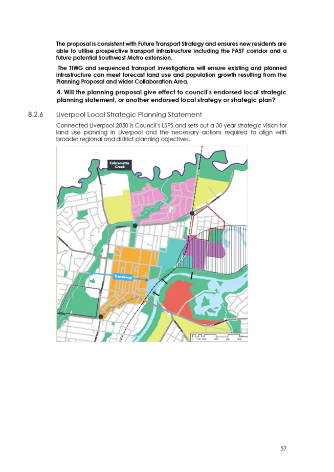
Council’s Local Strategic Planning Statement
(LSPS) also provides strategic support for the rezoning of the precinct. The
LSPS, adopted by Council earlier this year, states that Council will
‘investigate amendments to the LEP to rezone the river precinct north of
Newbridge Road (Moore Point) as a mixed-use zone to support the Liverpool CBD
and Innovation Precinct, with an extensive open space system and cross-river
linkages’ over the short-to-medium term.
The site and locality
The subject site is located in the Georges River North
(Moore Point) precinct, defined as being all lots bounded by Newbridge Road to
the south, the Georges River to the east and north, and Haigh Park, Lake Moore
and McMillan Park to the north and west. The primary access to the site is via
Bridges Road and Newbridge Road.

Figure 1: Aerial view of the Georges
River North precinct
Source: Nearmap 03 August 2020
The planning proposal request submitted to Council
seeks changes to those lots owned by a Joint Landowner Group (JLG) comprising
Leamac Property Group and Coronation Property. A separate planning proposal
request has been lodged within the precinct at 335-349 Newbridge Road, which is
currently under assessment.

Figure 2: Ownership of land within
the Georges River North precinct
Blue/yellow = Joint Landowner Group
Purple = other landowners
Source: Mecone 2020
The planning proposal request applies to six lots of
varying sizes represented in yellow and blue in Figure 2. All lots in
the precinct are currently zoned IN2 Light Industrial.
The site is currently used for a range of light
industrial purposes, the largest of which is Prysmian, a cable and electrical
wire manufacturer.
The Proposal
The planning proposal request seeks to amend the
Liverpool Local Environmental Plan to facilitate high-density mixed-use
development. It is envisaged that the development could support approximately
12,220 dwellings and provide 249,364m²
of commercial floor space over a long period to 2051.
An associated Urban Design Study envisages that the
entire precinct could ultimately accommodate approximately 14,054 dwellings and
344,499m² of commercial floor space, with a residential population of
approximately 30,760 persons. The gross residential density of the precinct
would be approximately 365 dwellings per hectare, with a residential population
density of 800 people per hectare, making it one of the densest urban
regeneration projects in Australia.
The proposal would be achieved through the following
amendments to the LEP:
· Rezone the site from IN2 Light Industrial
to B4 Mixed Use, B6 Enterprise Corridor and RE1 Public Recreation;
· Increase the maximum floor space ratio
(FSR) development standard to 4.2:1 and 3.5:1;
· Increase the maximum height of buildings
(HOB) development standard from 18m and 15m to RL 136 and RL 108; and
· Introduce Division 1A to the LEP to provide
site-specific development controls for the site including design excellence,
sun access and requirements for preparation of a development control plan. It
also seeks to amend the Key Sites Map such that Clause 7.22(4) applies to the
site, which would allow residential development within 50m of a classified road
within the B6 zone, as long as the development was more than 8m from the
classified road.
The intended Land Zoning Map is pictured in Figure
4, FSR in Figure 5, and HOB in Figure 6.
An illustrative masterplan for the entire precinct is
shown in Figure 7.

Figure 4: Intended zoning map for
Georges River North Precinct
NB: Striped land indicates land not
subject to planning proposal
Source: Mecone, 2020
Initially, the planning proposal request
did not include any RE1 zoned land, however the proposal was revised to include
RE1 land along the Georges River. Council officers recommend an additional 1.5
hectares be provided as an ‘open space investigation area’ adjacent
to Haigh Park, as well as additional RE1 zoned land of 40m from the top of bank
around Lake Moore, in order to better provide for active recreation onsite, and
for there to be an appropriate buffer between Lake Moore and development. Further
information on the request for additional open space is provided in the
planning assessment (Attachment 2).

Figure 5: Intended FSR map for
Georges River North Precinct
NB: Striped land indicates land not
subject to planning proposal
Source: Mecone, 2020

Figure 6: Intended HOB map for
Georges River North Precinct
NB: Striped land indicates land not
subject to planning proposal
Source: Mecone, 2020

Figure 7: Illustrative masterplan
NB: Striped land indicates land not
subject to planning proposal
Source: SJB, 2020
Council officers recommend that Council
endorse the illustrative masterplan (Figure 7) with the recommended
changes to guide future assessment of planning proposals in the Moore Point
precinct. Changes recommended include marking an additional 1.5 hectares as
‘open space investigation’ south-west of Haigh Park, and providing
a minimum 40m open space buffer from the top of bank of Lake Moore.
It is intended that a suitable staging and
sequencing plan will be further developed to ensure appropriate infrastructure
is in place to support development. An indicative staging plan for the subject
land has been provided as part of the Urban Design Study (Figure 8).
Council officers consider the planning proposal request should include clear
staging which limits the ability to obtain development consent for later stages
to ensure development is appropriately sequenced and supported by
infrastructure. How staging and sequencing will be implemented through planning
controls is expected to be resolved post-Gateway in close consultation with
DPIE, GSC, TfNSW and other state agencies.
An indicative render of the development is
provided at Figure 9.
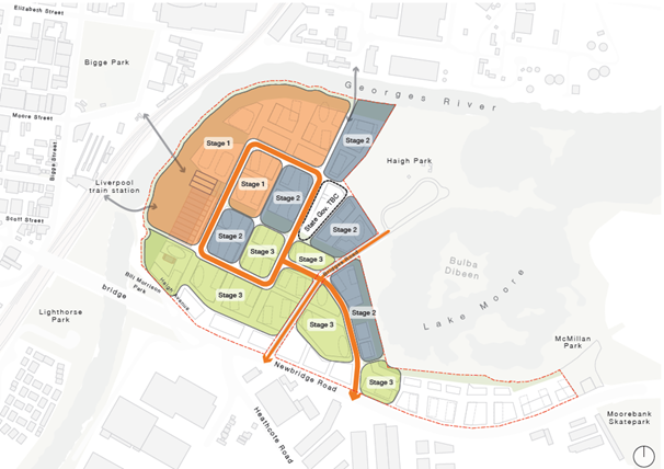
Figure 8: Indicative staging plan
Source: SJB

Figure 9: Indicative render of precinct
viewed from the east.
Source: SJB
Planning Assessment
The planning assessment report is contained in Attachment
2. It provides an assessment of the merits of the proposal against the
District and Region Plans, Council’s Local Strategic Planning Statement
and the Department’s ‘A Guide to Preparing Planning
Proposals’. The report concludes that the planning proposal request has
strategic and site-specific merit and should proceed to a Gateway
determination. The report notes that resolution of outstanding traffic and
flooding considerations is required, as well as changes to the planning
proposal request to increase the amount of public open space.
Local Planning Panel Advice
The planning proposal request was considered by the
Local Planning Panel at its 26 October 2020 meeting, and this advice is
included at Attachment 3.
The Panel agreed unanimously with the Council officers
conclusion that the planning proposal request has strategic merit, having
regard to the broader policy context, including the Greater Sydney Regional
Plan – A Metropolis of Three Cities, the Western City District Plan,
Local Strategic Planning Statement and the Liverpool Collaboration Area Place
Strategy.
A majority of the Panel (3-1) agreed that the planning
proposal request has site-specific merit, noting that the final form and
ultimate capacity of the site will be determined through the completion of
investigations that will determine the carrying capacity and configuration of
the Precinct. This includes:
· Detailed analysis of flooding conditions
and required mitigation and management measures;
· Outcomes of the strategic transport
modelling and transport impact assessment;
· Outcomes of the open space needs analysis
for the Collaboration Area (with in principle support given for a larger
quantum of open space, dependent on the outcome of the analysis); and
· Advice on the need for schools within the
precinct.
The Panel noted Council’s planning assessment
report detailing issues that required further resolution post-Gateway,
including:
· Contamination;
· The treatment of offensive odour from the
Liverpool water recycling plant;
· The extent of the riparian zone buffer and
its treatment;
· Urban design;
· Connectivity;
· Affordable housing – the Panel notes
and supports the Council officers recommended 5-10% affordable housing target;
· The quantum and extent of physical and
social infrastructure to support a major population and employment precinct;
· A suitable staging and sequencing plan to
ensure appropriate infrastructure is in place to meet the demands of the
precinct.
There was a dissenting view that the proposal is not
supported by appropriate studies, in sufficient detail, to establish whether
there is site-specific merit. This includes the following:
· Flooding – the minority opinion
believes there is insufficient information to assess environmental,
socio-economic and climate change-related impacts from the proposed flood
mitigation strategy;
· Connectivity – it is unclear whether
the three bridge connections to the Liverpool CBD, Innovation Precinct and
Warwick Farm can be adequately captured through a VPA or contributions plan to
a standard that is equitable and accessible to ratepayers, and that climate
change must be addressed in the design. It is argued that this must be resolved
at the planning proposal stage rather than at concept DA or DA stage;
· Aboriginal culture – the minority
opinion questions whether consultation has been done with the Gandangara Local
Aboriginal Land Council (LALC). It is stated that engagement with the LALC and
local Aboriginal community is pertinent at this stage of the planning proposal;
· Aquatic Ecology – there is no
information on the aquatic ecology values of the Georges River in Moore Point
or upstream in the compensatory flood storage locations. Given the large
potential disturbance footprint and infrastructure required for riparian
improvements, it is considered important to establish an understanding of
aquatic environment. The Coastal Management Plan objective to “protect
and improve the extent and condition of estuarine and riparian vegetation”
does not appear to have been considered.
Key issues
Traffic
Council’s traffic planning department have
provided in principle support to the planning proposal proceeding to a Gateway
determination. They note the strategic transport modelling work underway by
Transport for NSW which includes:
· Stage 1 - A strategic analysis of the
transport infrastructure required to support the planning proposal;
· Stage 2 - Detailed Transport and Traffic
Assessment in the context of a Transport Management Accessibility Plan (TMAP)
to identify the infrastructure and service requirements and determine
development contributions / SIC.
Flooding
Council’s Flood Plain and Water Management
department required the following in order to determine the suitability of the
proposal:
· A detailed hydraulic analysis to assess the
effectiveness of the proposed flood mitigation option;
· A flood impact assessment for all design flood events including the 1% AEP and PMF. Appropriate flood mitigation
measures shall be incorporated including provision of compensatory flood
storage and to demonstrate that there will be no adverse impacts on flood
levels and flow velocity in the river and on the adjoining properties;
· Further detail on how the proposed flood
mitigation option in Helles Park will ensure enhanced and effective recreation
uses, in addition to effective flood mitigation; and
· A revised flood evacuation strategy with
plans including levels to demonstrate that a continuous rising grade is
achieved to a level above the PMF.
Council officers have agreed that this
information is important and necessary, and that it must be provided at the
post-Gateway stage. Council
will also need to resolve whether off-site compensatory storage is an
acceptable solution, as it is currently not Council policy to support off-site
solutions. However, as part of the solution, the proponent has offered to
further embellish land at Helles Park to provide superior active recreation
facilities. Once the above
studies have been completed, Council staff will be able to make a
recommendation to Council regarding whether off-site flood mitigation can be
supported as a solution. If it is not, the planning proposal will need to be
amended to include on-site flood mitigation.
Environmental Health
Council’s Environment & Health department
have advised that the following information is required before they can support
the planning proposal being gazetted:
· a preliminary investigation of the land
carried out in accordance with the contaminated land planning guidelines
– the currently provided report does not fulfil all requirements of a
Stage 1 Preliminary Site Investigation as outlined within the contaminated land
planning guidelines referenced in Ministerial direction (No 2.6) issued 17th April 2020 and guidelines
made and approved by the NSW EPA under the Contaminated Land Management Act
1997.
· an acoustic report prepared by a suitably
qualified acoustic consultant for the noise sensitive development
Council officers have agreed that this information is
important and necessary, and that it must be provided at the post-Gateway
stage.
Part of the site is also affected by the Sydney Water
odour buffer, and Council will engage with Sydney Water post-Gateway to
understand whether they can support increased residential development within
the 2OU buffer. The Gateway determination will include Sydney Water as a state
agency that must be consulted.
Open Space
Council’s
Community Planning department raised concern with the provision of open space
in the proposal. Council typically requires 2.83 hectares of open space per
1000 persons. With a precinct-wide population expected to be 30,760 persons,
this would require 87 hectares for open space, including eight sports fields,
which is larger than the precinct itself.
It is clearly
understood that such metrics are not suitable for urban renewal areas, however
percentage-based open space metrics (for example 20% of site area), which have
been applied to the proposal and reflected in the proponent’s Community
Benefits Analysis (Attachment 10), are also problematic as they do not
account for density or open space capacity limits. In the case of this planning
proposal, the density is significantly higher than any other similarly scaled
urban renewal precincts in Sydney. For example, Green Square has a population
density of 211 persons per hectare, while Georges River North is predicted to
have an ultimate density of 799 persons per hectare.
Active recreation
demand triggered by the proposed development should primarily be addressed
within the development area, with Haigh Park a complementary open space area.
It is recommended that a metric of 1 hectare of open space be provided per 1000
persons, or 10 square metres per person, based on international best practice
examples. Currently the proposal provides for around 0.25 hectares per person,
or 2.5 sq m per person.
Council staff recommend
that an additional 1.5 hectares of open space be provided as an ‘Open
Space Investigation’ in line with Community Planning’s feedback and
the Community Benefit Analysis recommendation that there should be 1.5 hectares
for a district-level park on-site inclusive of sporting fields. The Community
Benefits Analysis suggests Haigh Park could support an additional two sporting
fields, which is supported by Community Planning.
It should be noted that
following the preparation of the planning assessment report by staff for the
Local Planning Panel, including the recommendation on open space, the proponent
submitted updated advice (Attachment 11) from the Community Benefits
Analysis consultant that contended that sports recreation does not need to be
provided on-site, and that Haigh Park could support one local sports space,
with two additional sports fields to be provided offsite. It is Community
Planning’s and the Council officer’s view that the provision of
only one informal sports space within Moore Point is not adequate for a projected
population of over 30,000 persons. A population of 30,000 residents warrants 8
soccer fields and 3 cricket pitches. The integration of additional sports
fields with Haigh park is acceptable for capacity building, integration and
co-location of recreation facilities.
Council staff support
the inclusion of 1.5 hectares of additional open space adjacent to Haigh Park
as ‘open space investigation’ while an open space needs assessment
is conducted for the entire Liverpool Collaboration Area. This will give
Council a better understanding of the quantum of open space required across the
Collaboration Area, and its necessary configuration and locations. It is also
noted that the proposal’s dwelling yield may need to be reduced following
the finalisation of studies, including transport and flooding. This may change
the amount of open space required to be provided.
Public Domain
Council’s City Design and Public
Domain department identified a number of urban design issues concerning built
form and public domain that will need to be resolved through the Place Making
and Statutory Planning Working Groups, post Gateway. While the scale of development is supported on the
east of the site closer to Liverpool Station, further consideration should be
given to the scale of development, including bulk and height of development
closer to Haigh Park and around Lake Moore. The proponents have suggested that
this can be addressed through the development of DCP controls, though the City
Design team have concerns that this could lead to challenges during the
development assessment stage. This issue will be closely considered in
consultation with the Department of Planning, Industry and Environment through
the next stages of the planning process.
There is also concern over the ‘urbanised’
treatment around Lake Moore, which is listed as a Coastal Wetland, and where
Council’s City Design and Public Domain unit indicate that the
environmental qualities of the lake should have primacy. This issue will also
be considered carefully by the Environment, Energy and Science Group (EES)
within DPIE as part of state agency consultation.
Council staff recommend the
planning proposal request be amended to provide a minimum 40m buffer of RE1
zoned open space surrounding Lake Moore in order to provide a suitable urban
design outcome. While recognising that other urban design issues need to be
addressed, as noted in the LPP report, it is considered that the refinement of
these detailed design elements can be undertaken during the post-Gateway stage
through inclusion into a site-specific DCP.
Section 10 of the
Liverpool Community Participation Plan (CPP) 2019 states the following:
For large scale planning proposals, Council will also
exhibit the planning proposal for 28 days prior to a Council decision on
whether to endorse the planning proposal for a Gateway determination. Feedback
from the community will be incorporated into a report to Council.
As required by Council’s Community
Participation Plan, the proposal was publicly exhibited for 28 days prior to
being reported to Council.
The proposal received three community
responses during this period, and one agency response. Of the three community
responses, one was in support, one was in opposition, and one was neutral.
The response in support of the proposal
came from the Liverpool Innovation Precinct, which comprises nine of
Liverpool’s largest organisations, including South Western Sydney Local
Health District; Ingham Institute for Applied Medical Research; Western Sydney
University; University of NSW; South Western Sydney Primary Health Network;
TAFE NSW; Department of Education and the University of Wollongong; and
Liverpool City Council. It is independently chaired by the Western Sydney
Business Chamber.
The submission stated that “Moore
Point represents the logical extension of the Liverpool CBD and will help to
reorientate the city towards the Georges River by providing several new
connections across the river between the Liverpool CBD, the transport
interchange and Moore Point, and a new community of residents who will seek to
connect to the Liverpool city centre in new ways.”
The submission stated that the Liverpool
Innovation Precinct seeks to leverage the strong health, research and education
assets of the Liverpool CBD to attract more private sector investment, and
employment opportunities in knowledge jobs, which requires an expansion of its
housing, cultural, recreational and amenity opportunities, which Moore Point
would deliver.
The submission objecting to the proposal
was from a resident and ratepayer. The objection was based on the proposal
likely adding to congestion already experienced on Newbridge Road. It also
objected to the proposal on the basis that the land is flood prone, and that
Newbridge Road floods during heavy rain events, making the site unsuitable for
further development.
The final submission suggested that the
proposal may fall short by seeking to maximise residential and commercial
space, and that Covid-19 may require amendments to better accommodate changing
social and commercial needs. It also stated that the proposal didn’t
respond to the need for parking, and that a parking station should be
incorporated into the development.
One state agency, Schools Infrastructure
NSW, responded to the proposal, stating that the proposal would lead to a
substantial increase in the total number of government primary and secondary
school students, which would be more than can be accommodated at existing
schools. SINSW requested further ongoing consultation to ensure educational
facilities are supporting community needs and are appropriately resourced to
service future population growth.
Next Steps
If Council supports in principle the planning proposal
request, a formal planning proposal will be prepared and submitted to the
Department of Planning, Industry and Environment (DPIE) seeking a Gateway
determination.
A further report will be provided to Council following
the public exhibition period detailing submissions received and any amendments
proposed.
It is recommended that
Council support in principle the planning proposal request with the changes
recommended by staff, as the proposal demonstrates strategic and site-specific
merit. The finalisation of necessary studies can be conditioned through the Gateway
process.
|
Economic
|
Further develop a commercial centre that accommodates a variety of
employment opportunities.
Deliver and maintain a range of transport related infrastructure such
as footpaths, bus shelters and bikeways.
Encourage and promote businesses to develop in the hospital health and
medical precinct (of the City Centre).
Provide efficient parking for the City Centre.
Facilitate economic development.
|
|
Environment
|
Manage the environmental health of waterways.
Protect, enhance and maintain areas of endangered ecological
communities and high quality bushland as part of an attractive mix of land
uses.
Support the delivery of a range of transport options.
|
Social
|
Preserve and maintain heritage, both landscape and cultural as urban
development takes place.
Regulate for a mix of housing types that responds to different
population groups such as young families and older people.
|
Civic
Leadership
|
Operate a well developed governance system that demonstrates
accountability, transparency and ethical conduct.
|
|
Legislative
|
Environmental Planning And Assessment Act 1979
|
|
Risk
|
The risk is deemed to be Low. If Council does not
support the planning proposal request, there is a risk that the landowner
will seek a review of Council’s decision by the Sydney Western City
Planning Panel.
|
1. Applicant's
Planning Proposal Request
2. Local
Planning Panel Report
3. Local
Planning Panel advice
4. Urban
Design Study
5. Amended
Urban Design Analysis
6. Aboriginal
Heritage Report
7. Aeronautical
Assessment
8. Air
Quality Assessment
9. Biodiversity
Assessment
10. Community
Benefits Analysis
11. Community
Benefits Analysis Addendum
12. Demographic
Analysis
13. Economic
Impact Assessment
14. Flood
Evacuation Strategy
15. Flood
Impact Assessment
16. Historical
Heritage Assessment
17. Interim
Letter of Offer - Voluntary Planning Agreement
18. Benchmarking
report
19. Part
1 Contamination Assessment
20. Part
2 Acid Sulfate Management Plan
21. Place
Design Framework
22. Riparian
Strategy
23. Riparian
Strategy Appendix A
24. Servicing
Infrastructure Report
25. Strategic
Transport Impact Assessment
26. Sustainability
Statement