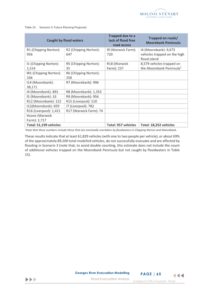
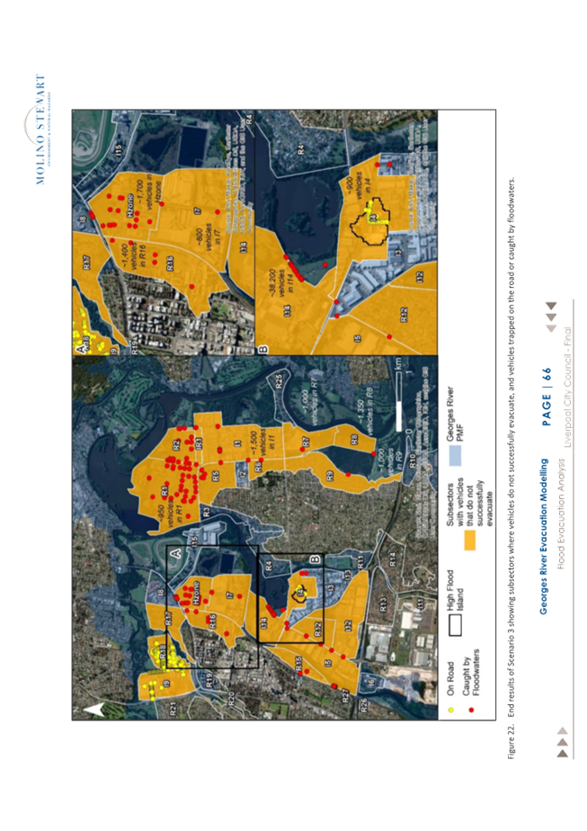
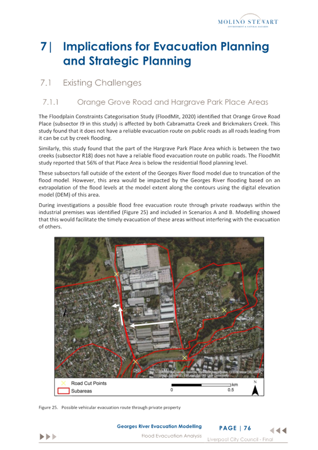
Governance
Committee Meeting
9 April 2024
Infrastructure and Planning Committee Report
|
ITEM 01
|
Warwick Farm Precinct Plan: Issue and
Option Paper
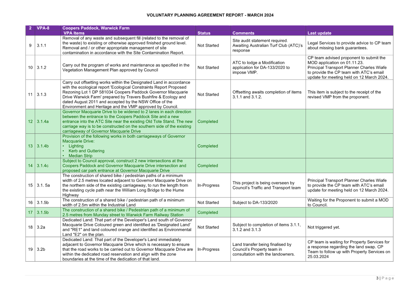
|
|
Strategic Objective
|
Evolving,
Prosperous, Innovative
Implement
planning controls and best practice urban design to create high-quality,
inclusive urban environments
|
|
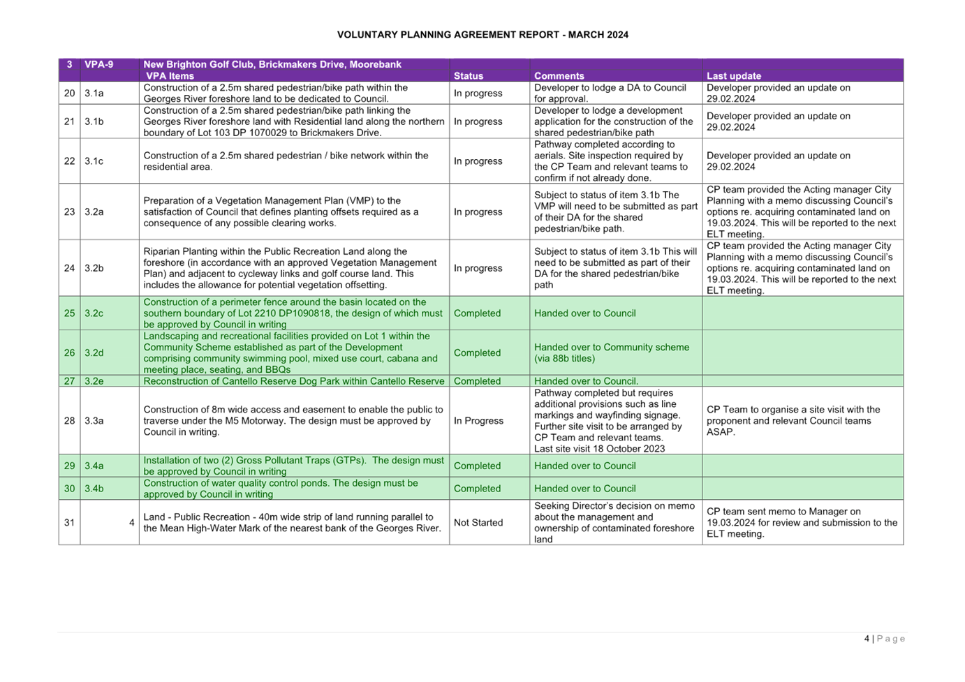
File Ref
|
020367.2024
|
|
Report By
|
Brianna Van Zyl -
Senior Strategic Planner
|
|
Approved By
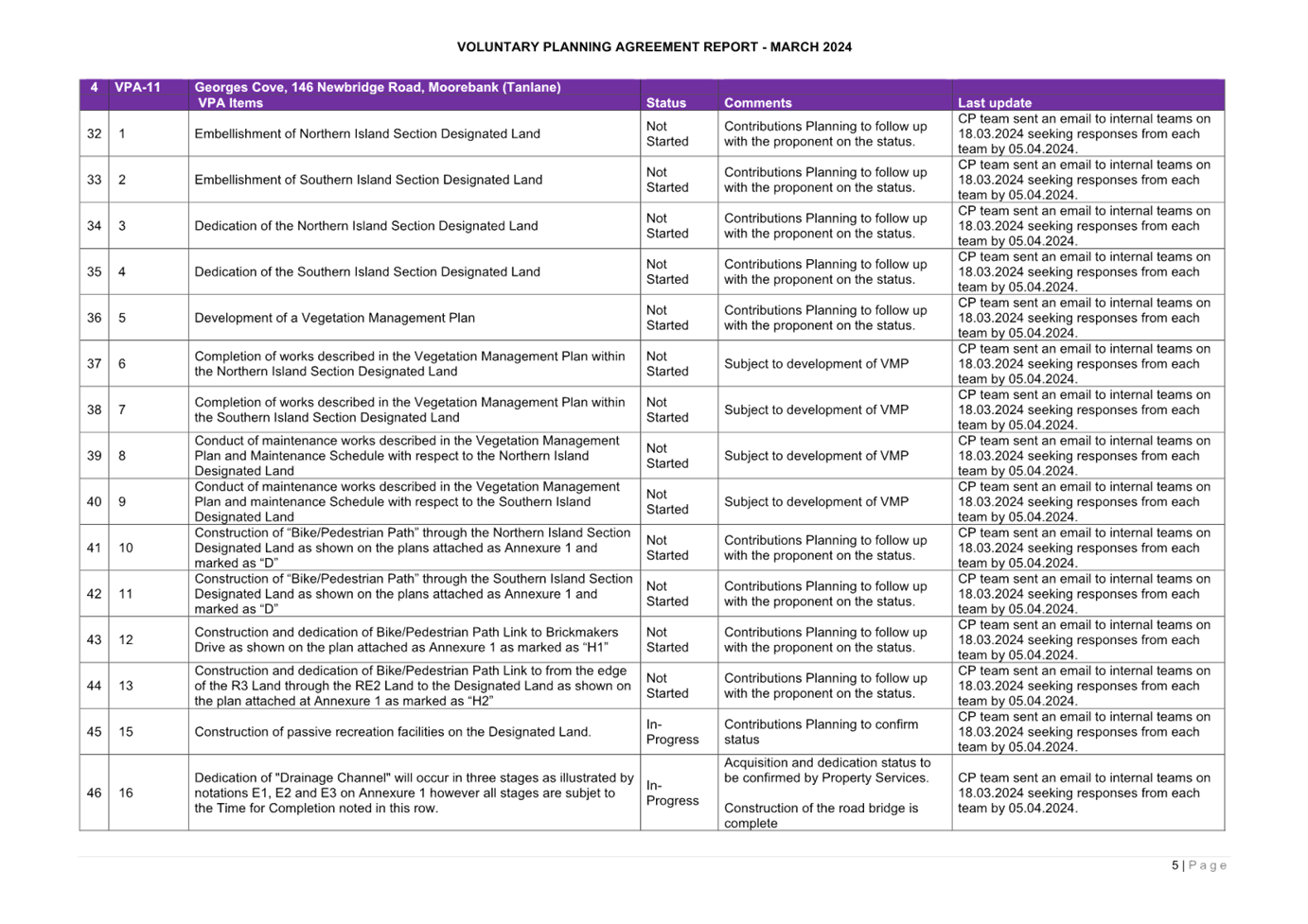
|
Lina Kakish - Director
Planning & Compliance
|
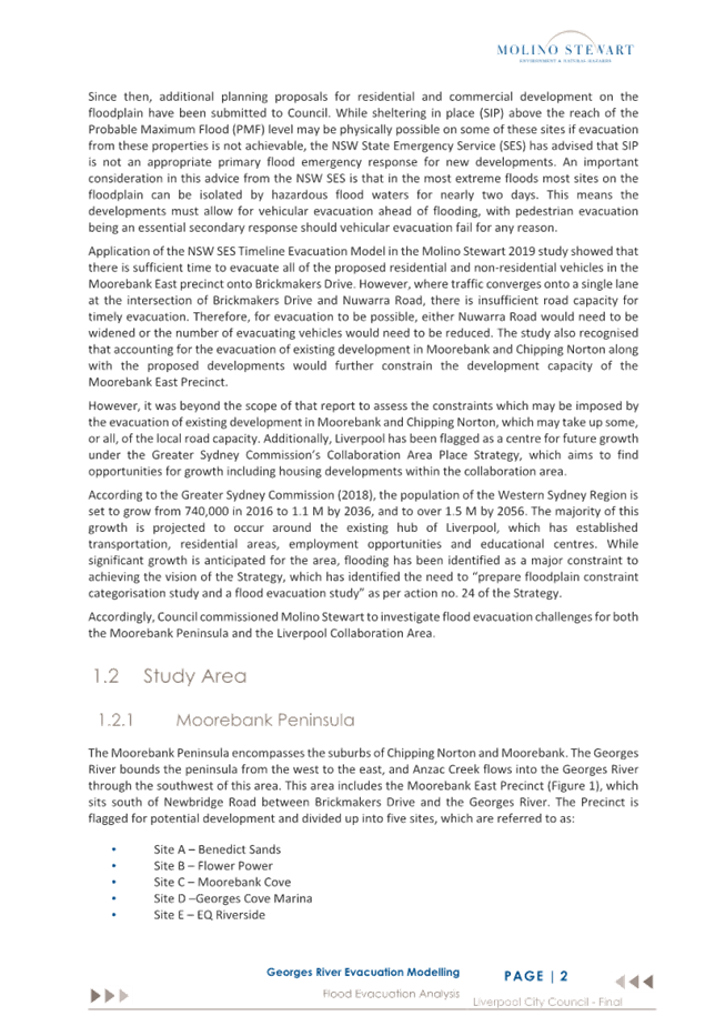
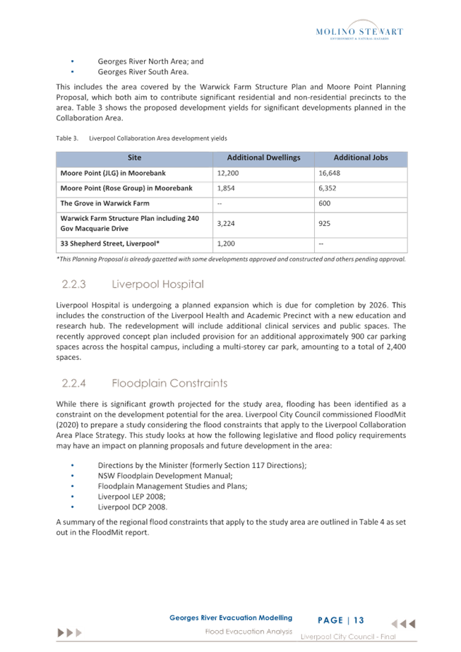
The Warwick Farm Structure Plan (Attachment 1),
developed by Council in 2020 and 2021 for the Warwick Farm horse training area,
has been on hold since 24 November 2021 when Council resolved that:
· ‘Council is provided with the information
that allows Council to make a fully informed and fully educated decision on
this matter, including the finalised regional flood evacuation study’.
Council
completed a Flood Evacuation Study for
the Liverpool Collaboration Area and Moorebank, by Molino Stewart, in 2022 (Attachment
2). Since then, following various
significant flood events across NSW, the NSW Government published the NSW Flood
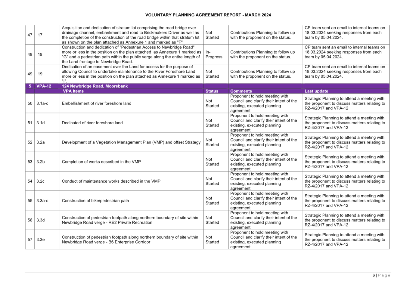
Inquiry. The NSW Flood Inquiry findings included recommendations that affected
the Georges River Catchment (which includes the Warwick Farm Precinct), which
was considered one of the high-risk catchments.
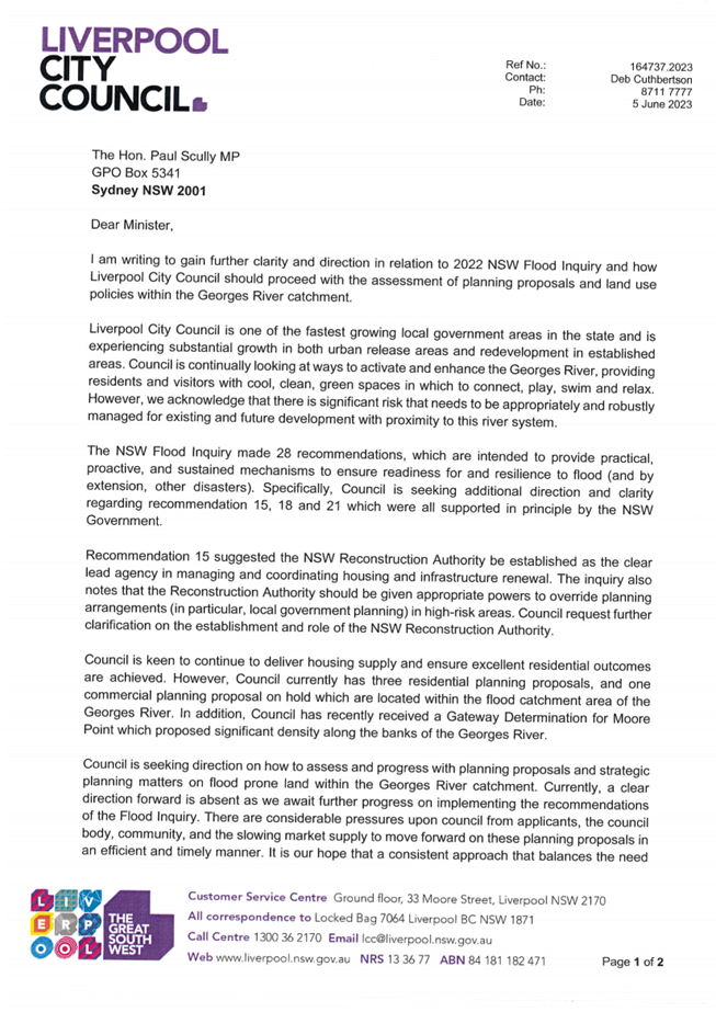
As
a result, Council sent a letter to the Hon. Paul Scully, Minister for Planning
and Public Spaces, on 5 June 2023 (Attachment 3). This letter sought
further clarity around how Council should proceed with the assessment of
Planning Proposals and land use policies within the Georges River catchment.
Council
received a response on 22 September 2023 (Attachment 4) which reiterated
the need for a risk-based approach to managing potential floods, stating the
level of assessment undertaken for Planning Proposals and Development
Applications must include a balanced consideration of all the risks and
impacts. This response has acted as a catalyst for the Precinct Plan being
re-presented to Council.
This
Report outlines the issues associated with the Warwick Fam Precinct, as well as
the latest Precinct Plan, including flooding, traffic, feasibility, and land
fragmentation. This Report also aims to provide further clarity to the
community, and to establish clear next steps for the Precinct.
Council staff have identified three options on how to
proceed, with these options detailed within this Report:
· Option 1 – Proceed with the existing Precinct
Plan (November 2021);
· Option 2 – Conduct further investigations to
rezone the Precinct to an industrial / innovation Precinct; or
· Option 3 – Retain existing zoning and
development standards.
Due
to existing constraints within the Precinct, and logistical issues proceeding
with Option 1, Council staff are recommending proceeding with Option 2. This
would provide opportunity for the rejuvenation of the Precinct, in a way that
complements the Liverpool City Centre, whilst still addressing the
environmental constraints. An industrial / innovation Precinct would also allow
for the existing animal and training establishments to remain which supports
the Warwick Farm Racecourse.
The
next steps will involve a Council report to the next available Council meeting
which will outline the options presented below.
That the Committee receives and notes this Report, and the proposed
options on how to proceed with the Warwick Farm Precinct Plan.
Background Information
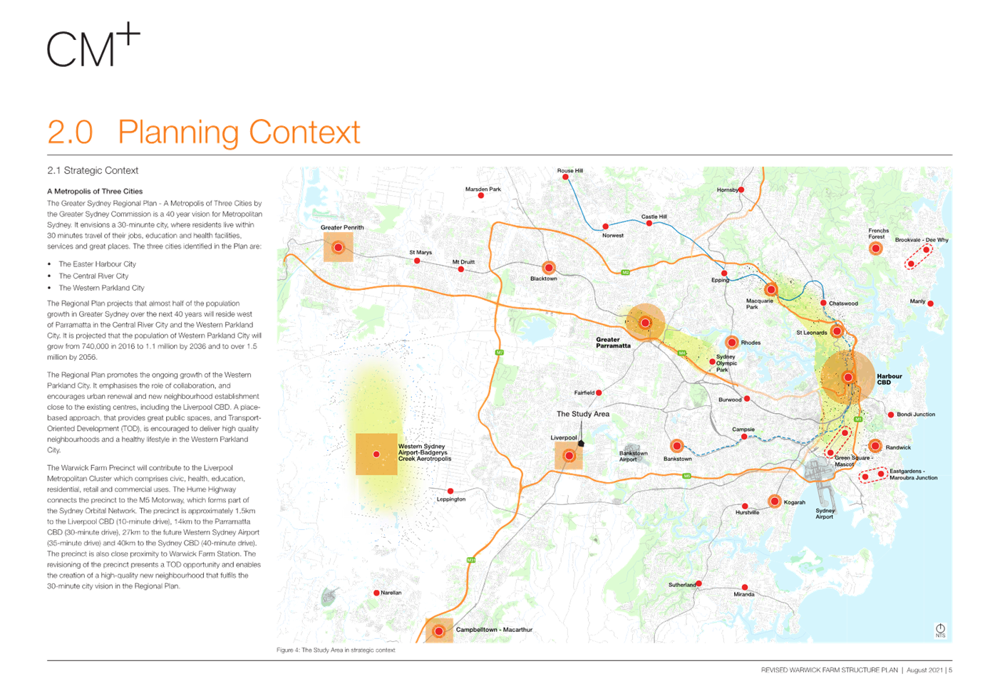
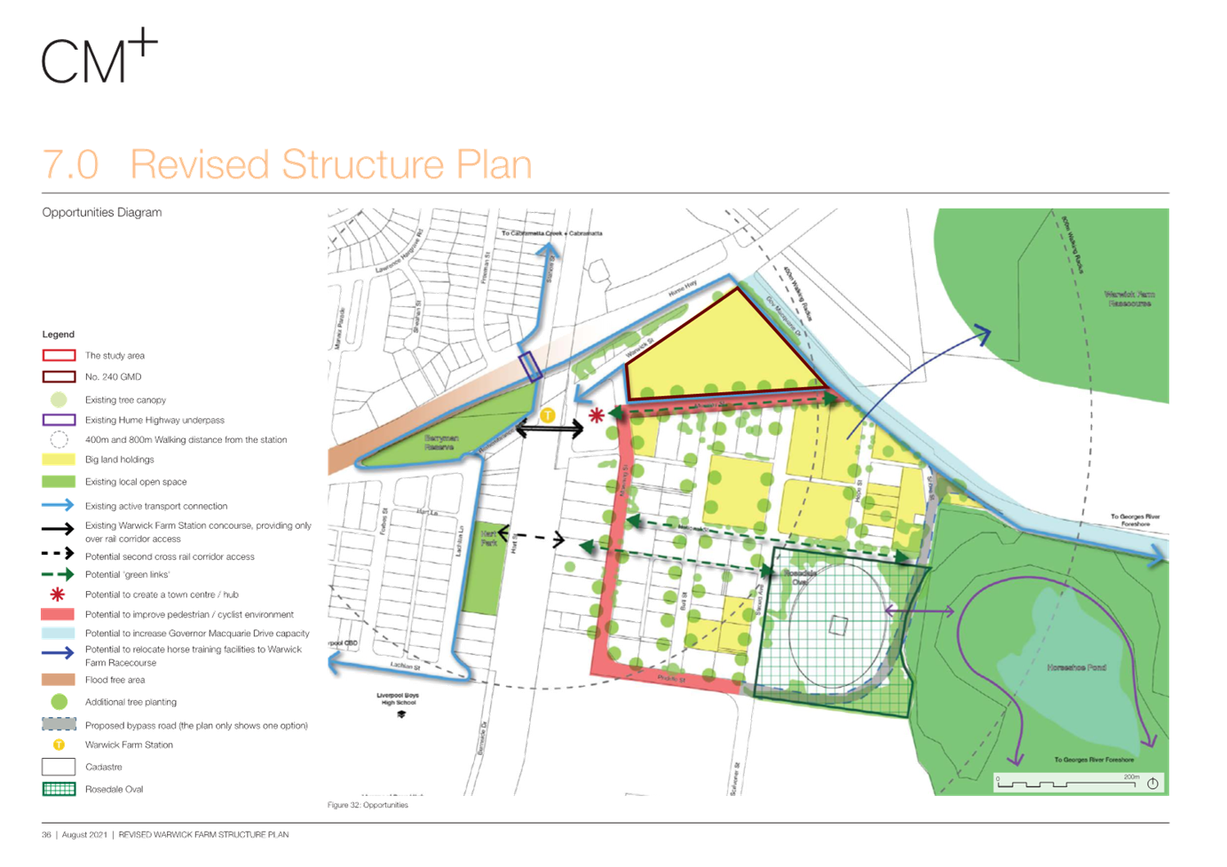
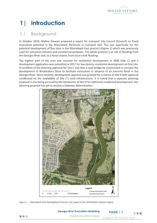
The
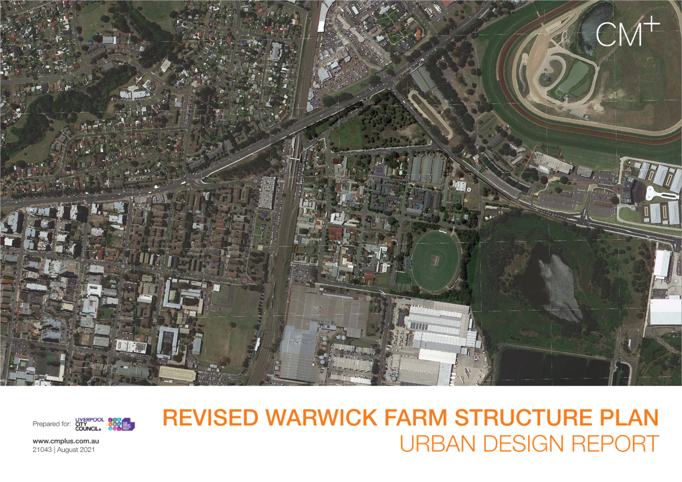
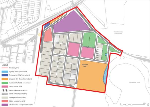
Study Area
The
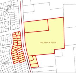
study area comprises approximately 25.5ha (including roads) and is bounded by
the Hume Highway, Shore Street, Warwick Farm Sewage Treatment Plant land,
Priddle Street, the Main South Railway Line, and Governor Macquarie Drive
within Warwick Farm. It is located approximately 1-1.5km north-east of the
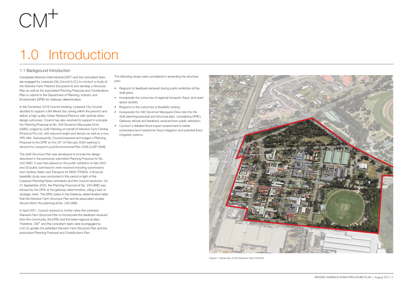
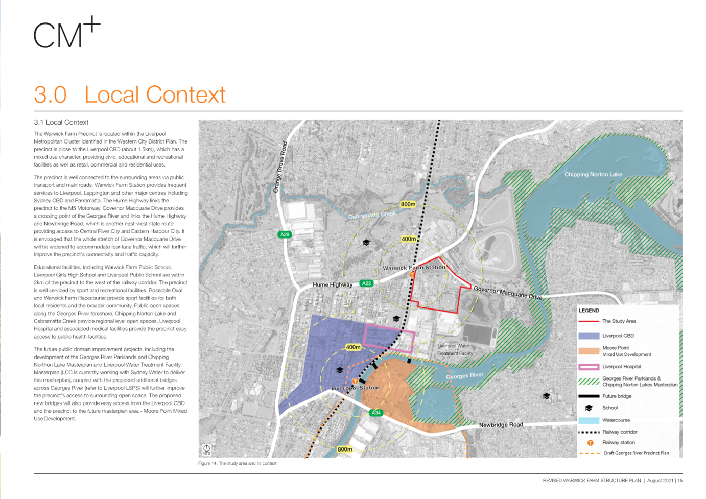
Liverpool City Centre and 13.5km south-west of Parramatta. Figure 1
shows the location of the study area.
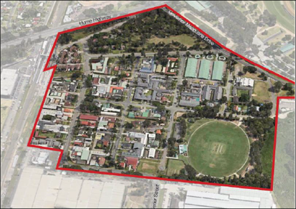
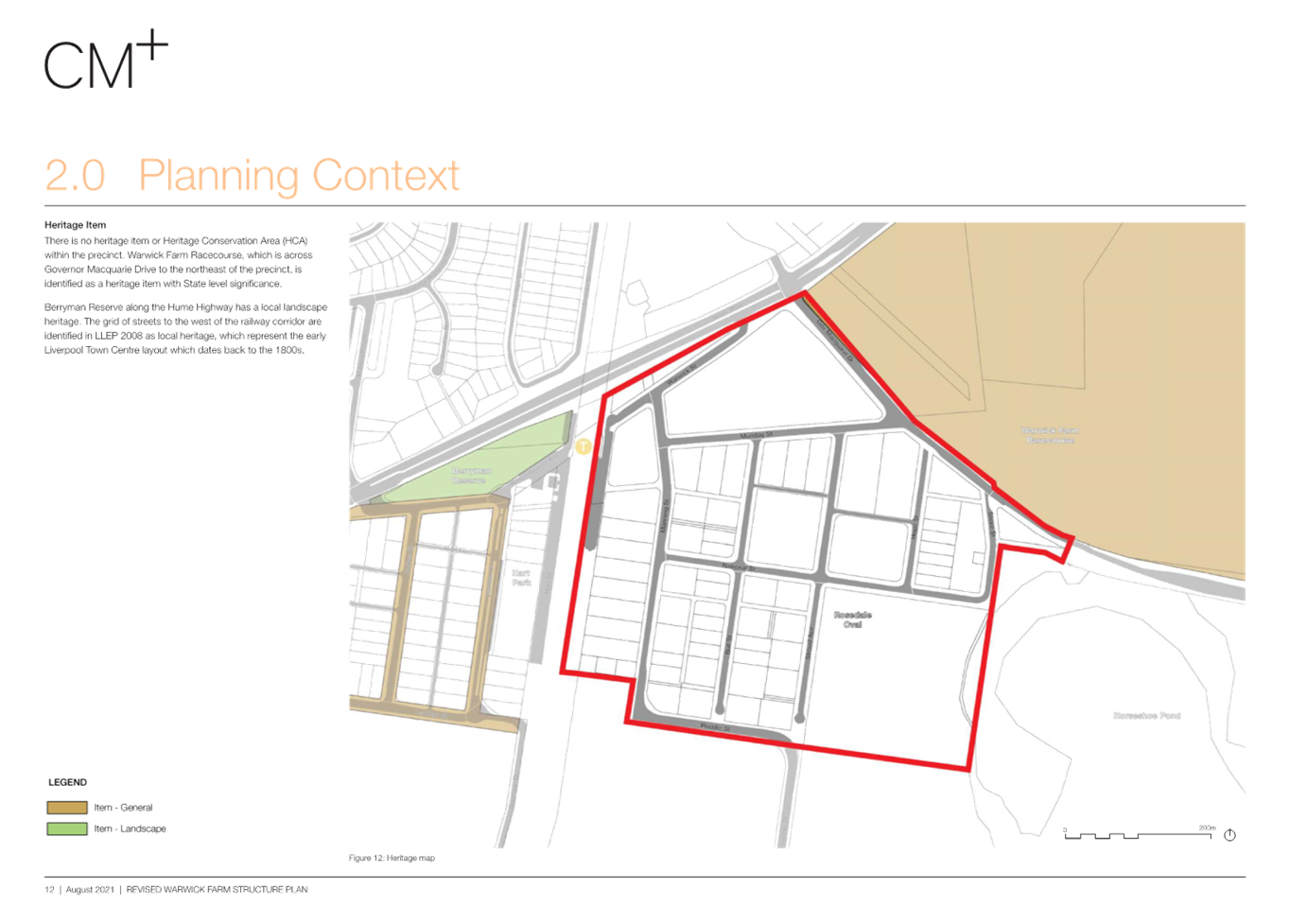
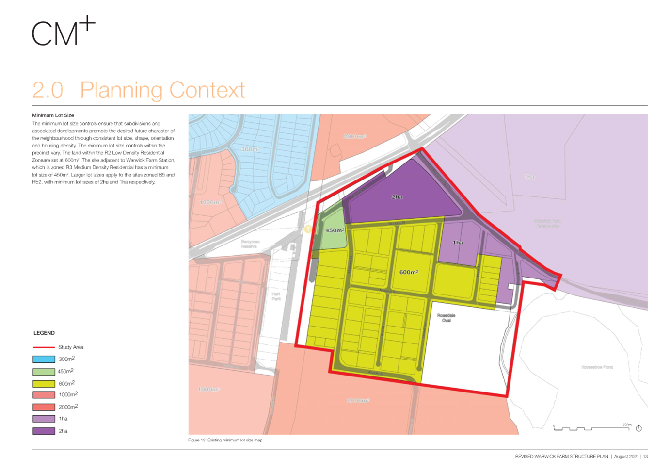
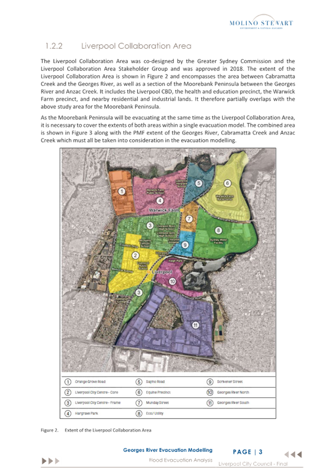
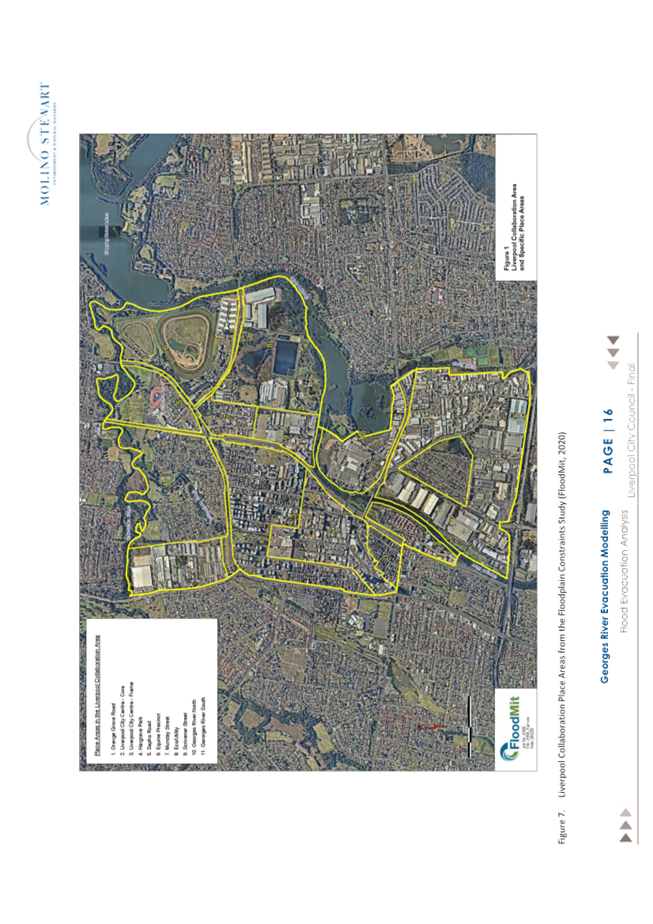
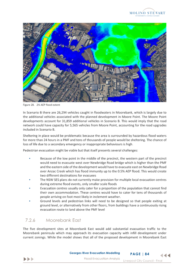
Figure
1: Precinct Boundaries shown in red (Source: CM+)
History
On
11 December 2019, Council resolved to direct the CEO to engage Consultants to
prepare a Precinct Plan for the rezoning of the Warwick Farm Precinct for a mix
of uses. Council appointed a multi-disciplinary team led by Conybeare Morrison
to prepare the supporting investigations to inform a Precinct Plan, including a
Draft Contribution Framework for the provision of new infrastructure to support
the Precinct.
Following
the initial Council Resolution, the following has occurred:
· 25 March 2020: Council endorsed (EGROW11) the Local Strategic Planning Statement (LSPS)
which included ‘Action 10.2’ which commits to developing a
Precinct Plan and Planning Proposal for the Warwick Farm Racing Precinct.
· 27 July 2020: The draft Precinct Plan, Planning Proposal and associated studies were
presented to the Liverpool Local Planning Panel. The Panel did not support the
Planning Proposal proceeding to a Gateway determination, requiring updates to
the flood impact assessment, further analysis on the potential environmental
impact of the truck bypass and a report in relation to the cap of 18,800
addition dwellings for the Liverpool Collaboration Area.
· 26 August 2020: Council considered the advice from the Panel and resolved that the draft
Precinct Plan, Planning Proposal, and associated Contributions Plan be placed
on public exhibition for 28 days.
· 14 September 2020 to 12 October 2020: The Precinct Plan was placed on public exhibition.
· 28 April 2021: The outcomes of the public exhibition were presented to Council (EGROW
04) where Council resolved for several changes to be made to the Structure
Plan, Planning Proposal and Contributions Plan. Such amendments included: the
inclusion of 240 Governor Macquarie Drive in the Precinct Plan, additional
flooding considerations, and an Economic Review of the resultant gross floor
areas achieved across the site to determine feasibility.
· 29 September 2021: A Report detailing the changes to the draft package was tabled at
Council. Council resolved (PLAN06) to place the Structure Plan, Planning
Proposal and Local Contributions Plan on public exhibition.
· 8 October to 7 November 2021: The Planning Package was placed on public exhibition.
· 24 November 2021: The results of community consultation were reported to Council where the
following was resolved: “That Council defer this matter until Council
is provided with information that allows Council to make fully informed and
fully educated decisions on this matter, including the finalised regional flood
evacuation study.”
NSW Government Flood Inquiry
Since Council placed the Precinct Plan on
hold, the NSW Government conducted the NSW Flood Inquiry in 2022. The Flood
Inquiry made several recommendations that relate to the Georges River, which
was considered a high -isk catchment along with the Hawkesbury-Nepean, Wilsons,
and Tweed River catchments. This has added an additional layer of complexity to
the Precinct.
Council staff have sought direction and
clarity from the Department of Planning, Housing and Infrastructure (DPHI) on
how to proceed with proposals in high and medium flood risk areas (Attachment
3). In September 2023, Council received a response from the DPHI on behalf
of the Hon. Paul Scully, Minister for Planning and Public Spaces, which
identified the need to move to a risk-based approach to managing potential
floods (Attachment 4). The letter stated that the level of assessment
undertaken for planning or development proposals are proportionate, and must
include balanced consideration on the merits, risks and impacts.
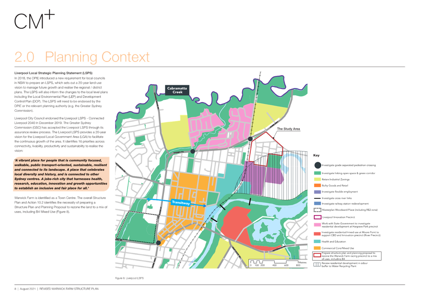
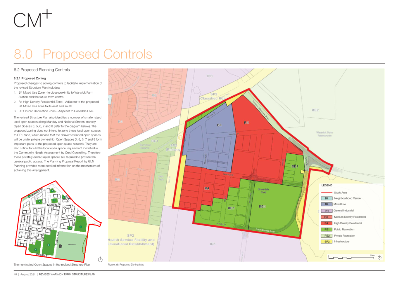
Zoning under Liverpool Local Environmental Plan
2008
Under
Liverpool Local Environmental Plan 2008 (LLEP 2008), the Precinct
contains a variety of existing land use zones:
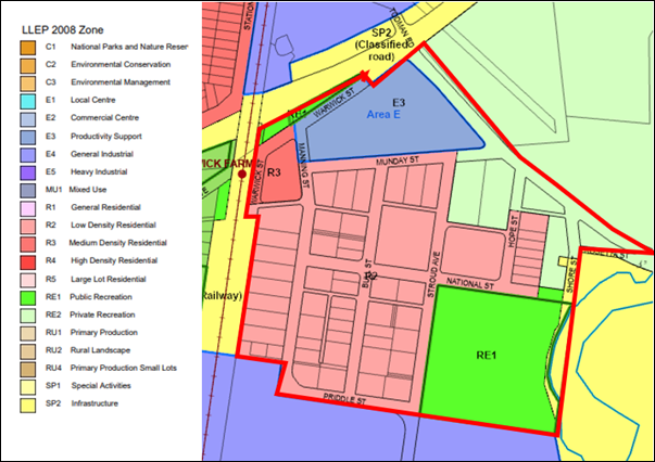
Figure
2: Existing Zoning map of Warwick Farm Precinct
E3 Productivity Support: This zone applies to 240 Governor
Macquarie Drive between Munday Street, Warwick Street and Governor Macquarie
Drive. The E3 Productivity support zone (formally B5 Business Development)
permits offices, light industrial as well as warehouse or distribution uses
(among others), however prohibits any residential uses. This land is currently
vacant but was subject to a Planning Proposal to rezone to MU1 Mixed Use
(formally B4 Mixed Use) and R4 High Density Residential. This detailed further
below.
R2 Low Density Residential: This zone applies to the majority of the
residential within the Precinct and permits dwellings houses which make up most
development in this zone. Clause 16 of Schedule 1 of the LEP also permits
animal boarding or training establishments, farm buildings and veterinary
hospitals in the R2 zone which reflect several horse boarding and training
establishments located in this area. Heights in this zone are limited to 8.5m
with an FSR of 0.5:1.
R3 Medium Density Residential: This zone applies to a small pocket of land located opposite the
station and developed with 2 storey townhouse style development. Heights in
this zone are currently limited to 8.5m with an FSR of 0.5:1.
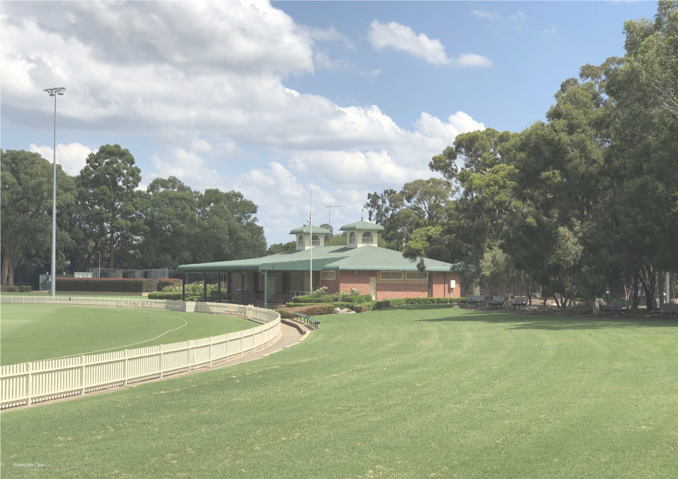
RE1 Public Recreation: This zone applies to Rosedale Oval and the embankment supporting
the Hume Highway overpass.
SP2 Sewerage Systems: This zone applies to land immediately east of the Rosedale
Oval playing surface and corresponds with the location of Horseshoe Pond and a
small section of Shore Street within the Precinct.
RE2 Private Recreation: This zone applies to land fronting Governor Macquarie Drive and
Shore Street in the northeast of the Precinct. It primarily accommodates horse
boarding and training premises.
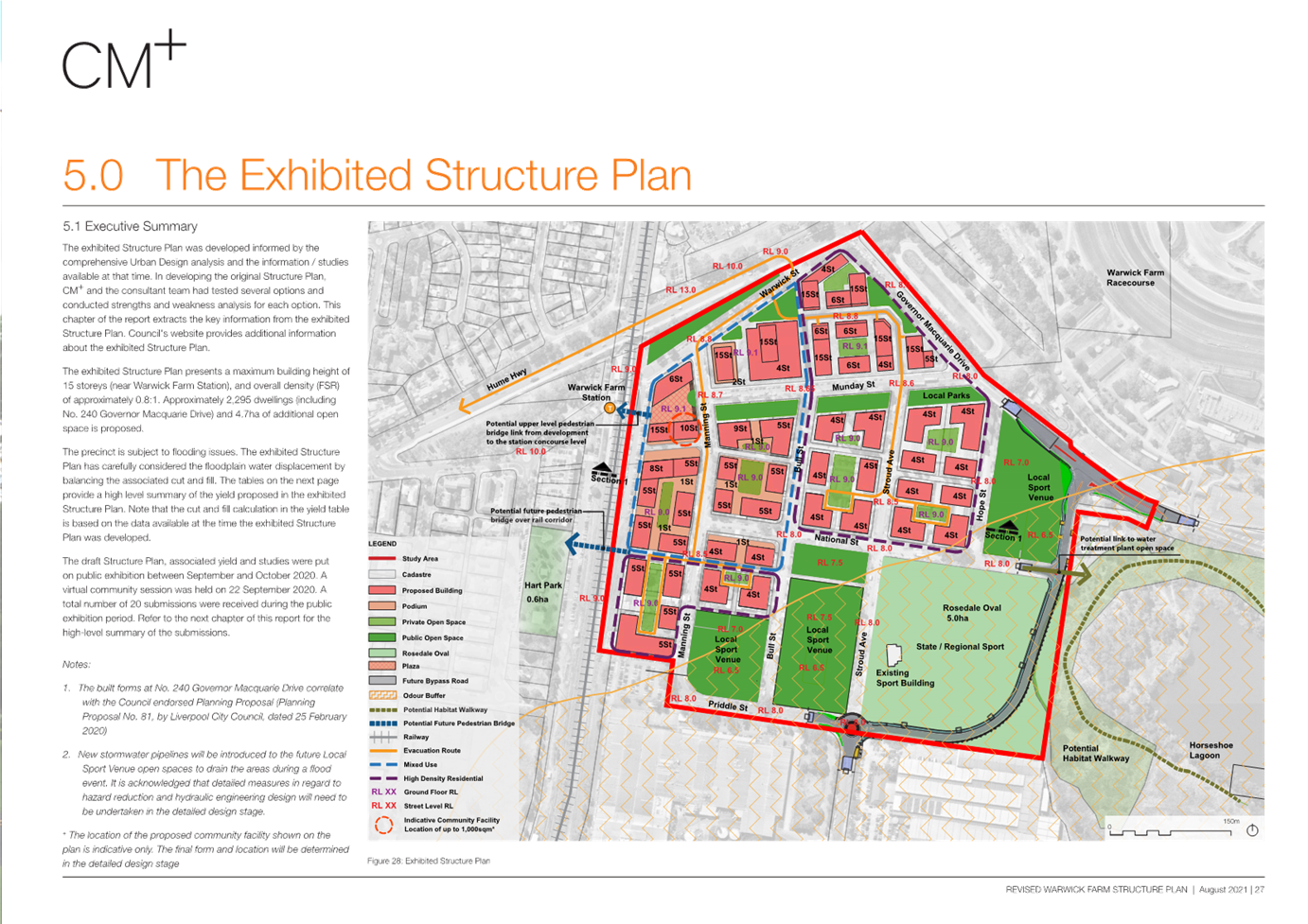
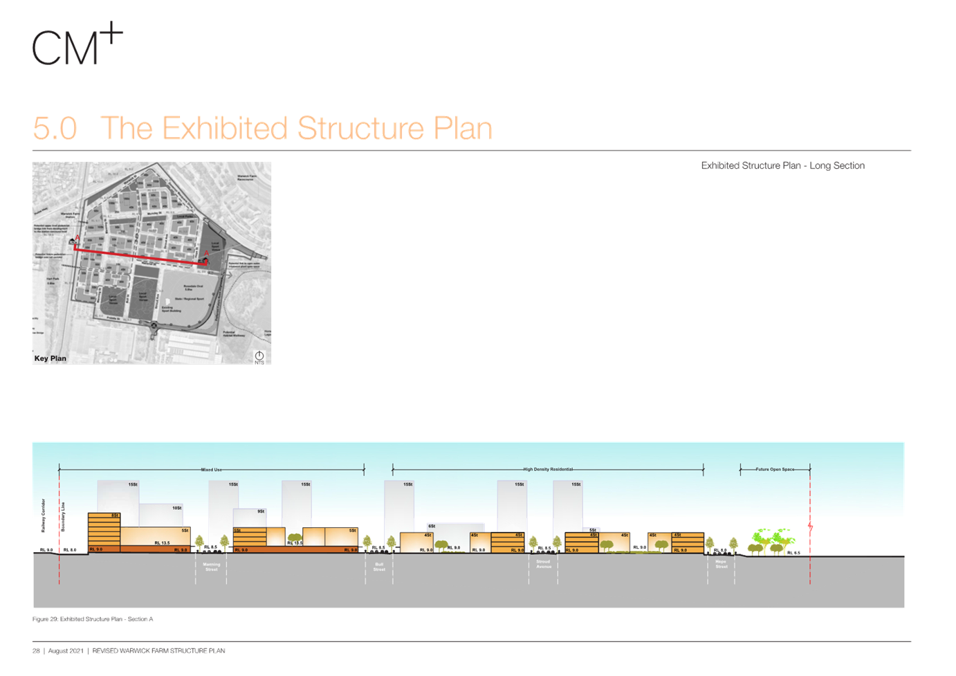
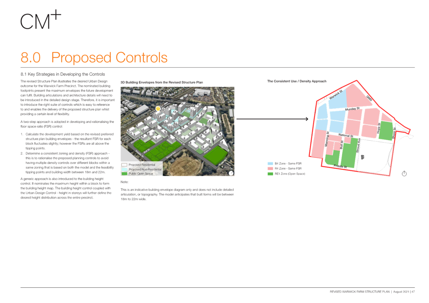
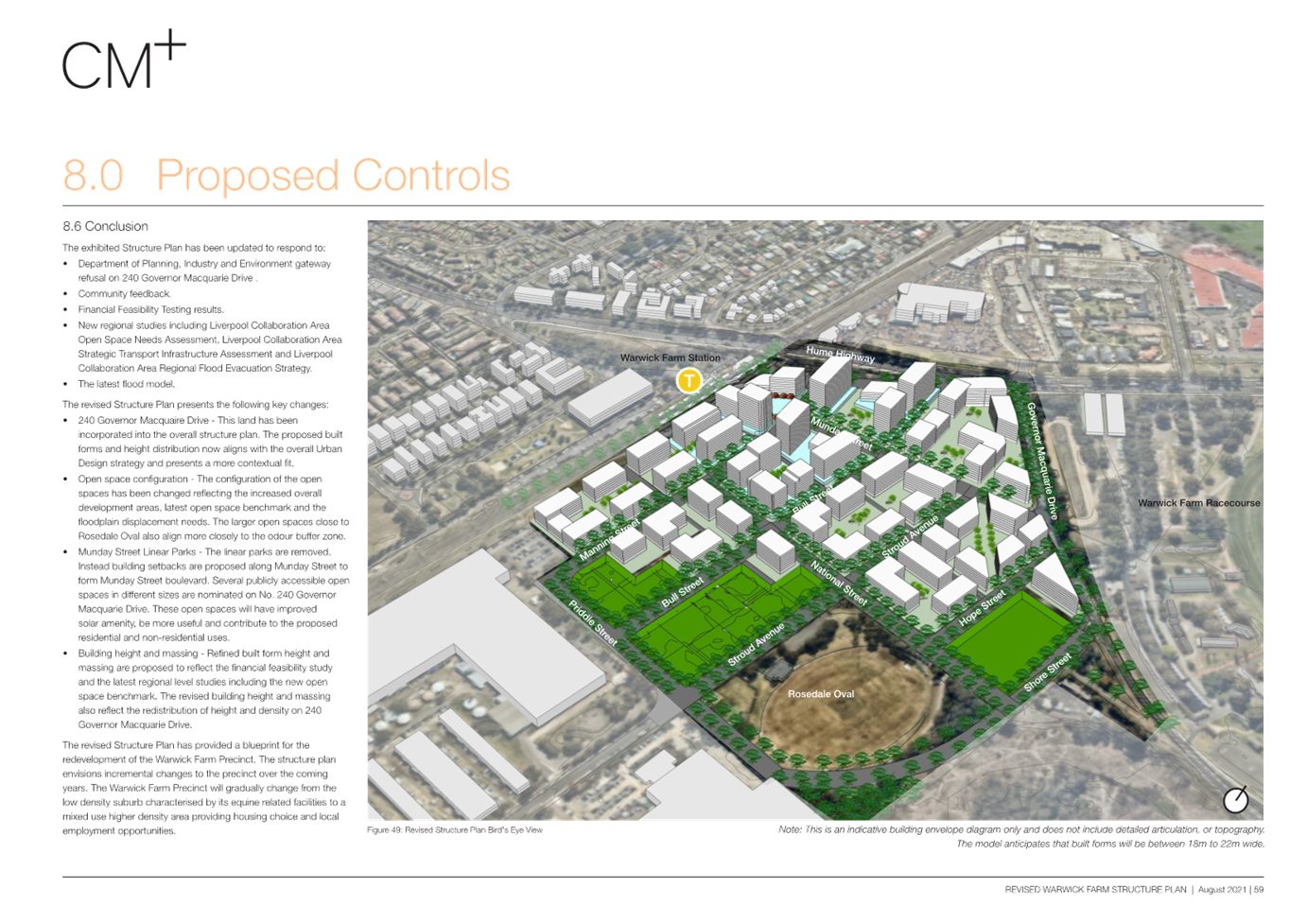
Draft Precinct Plan
(September 2021)
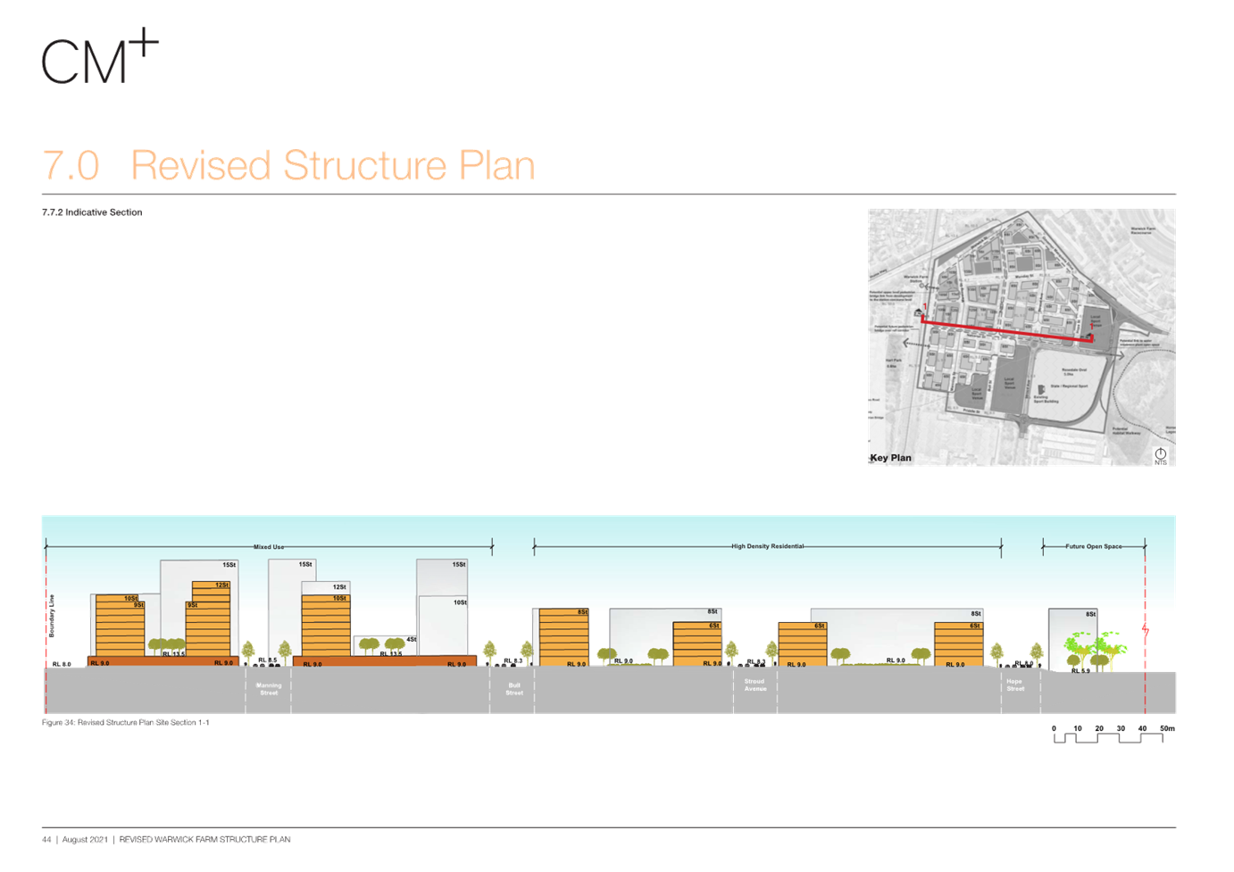
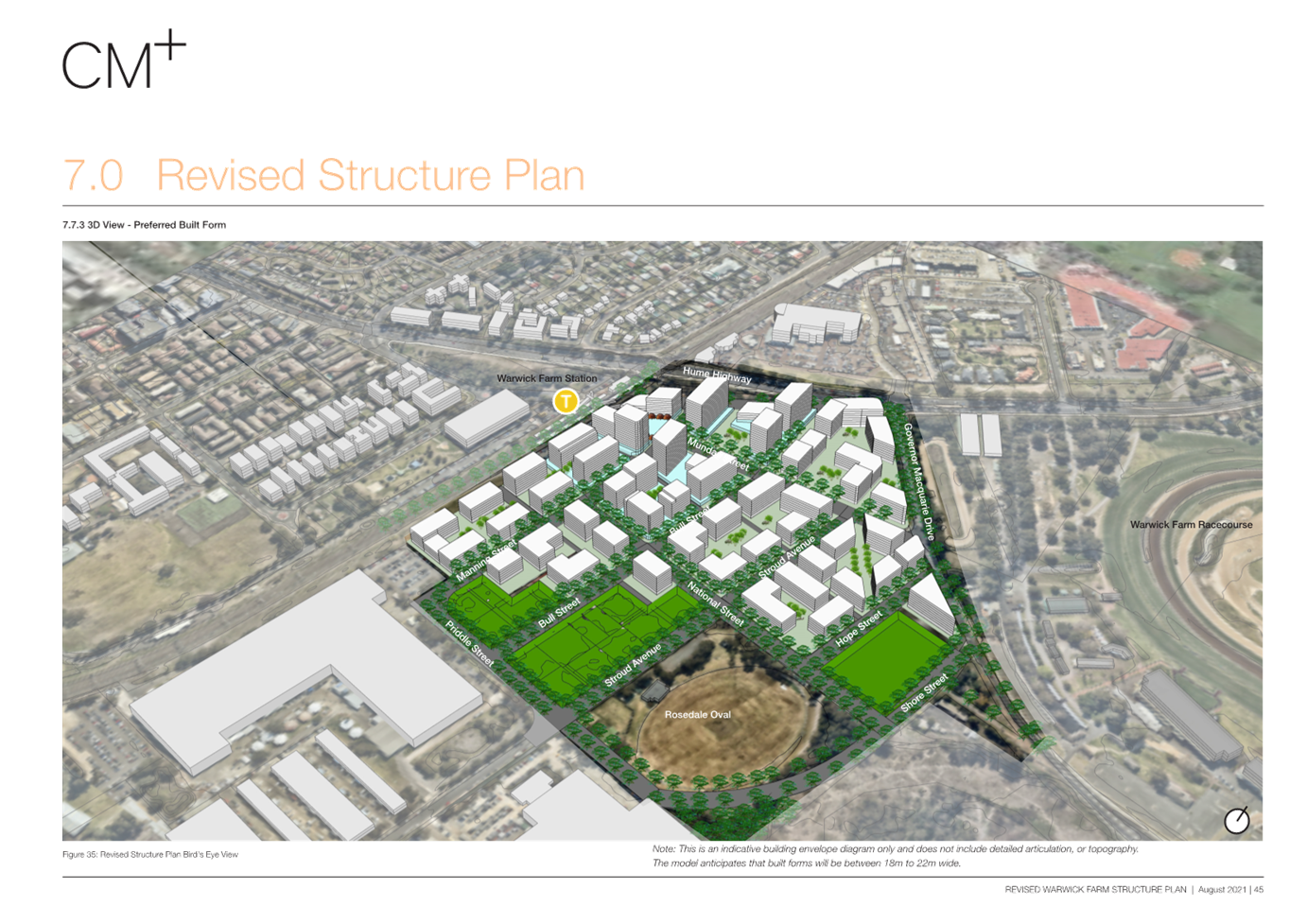
The most recent Structure Plan (Attachment 1)
(prepared by CM+ dated 26/09/2021, presented to Council on 24 November 2021)
depicts the redevelopment of the Precinct for mixed use development including
residential development.
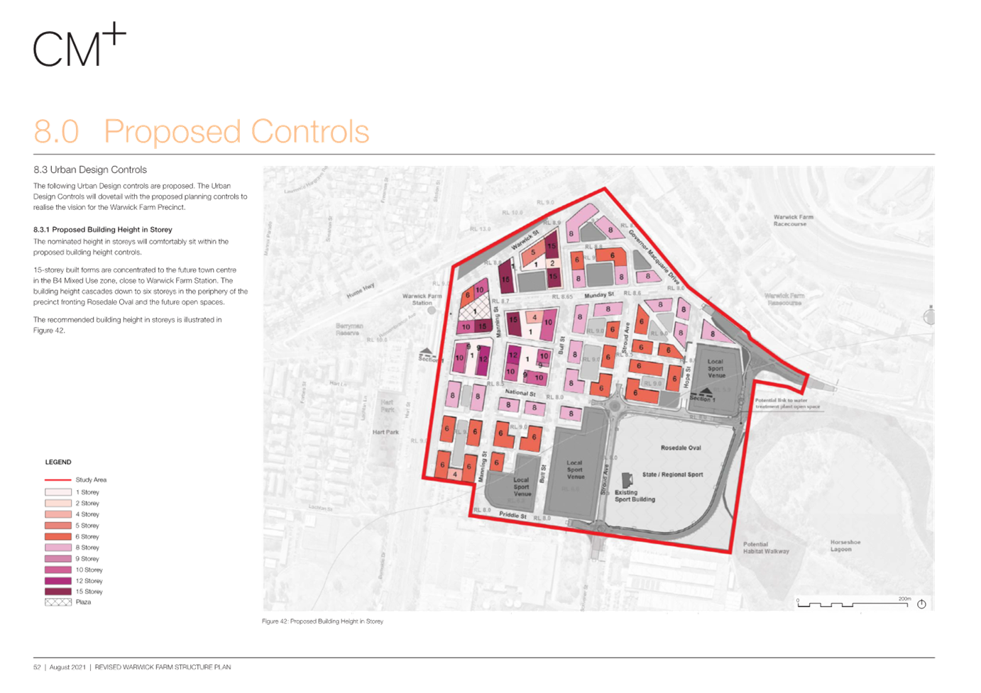
Key
features of the Precinct Plan include:
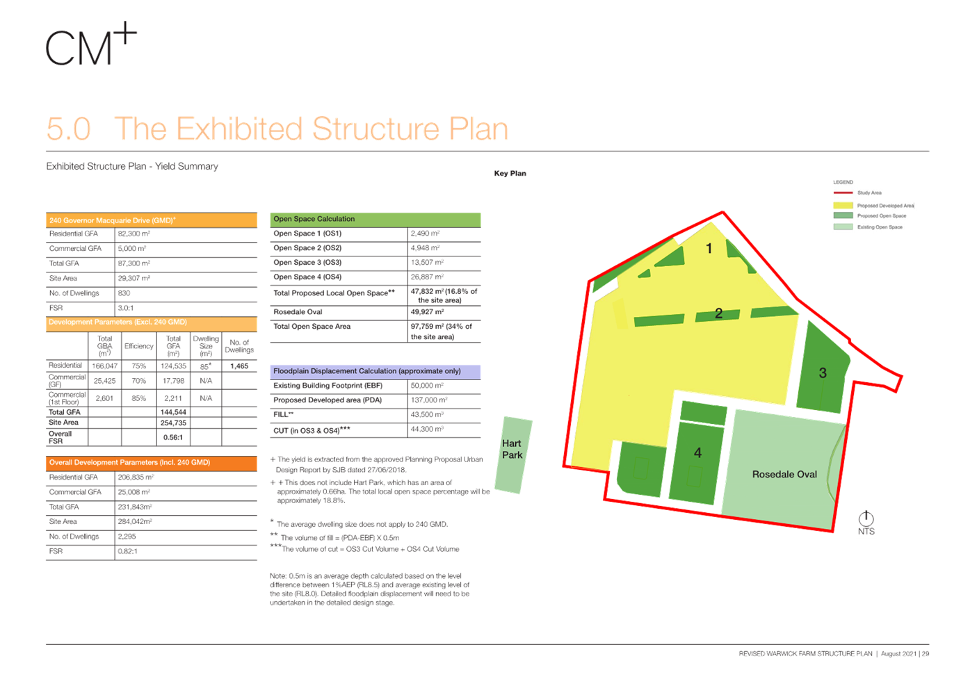
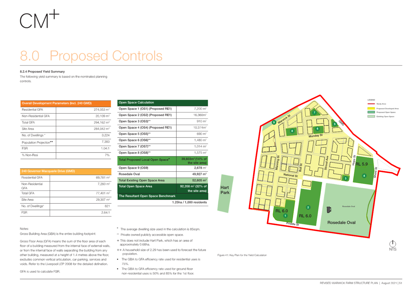
· A total of 294,162m2 GFA, with:
o 274,053m2 of residential GFA
o 20,109m2 of commercial GFA
· Capacity for approximately 3,224 new residential
dwellings (based on an average dwelling GFA of 85m2) and a
population of approximately 7,383 (based on 2.29 persons per dwelling).
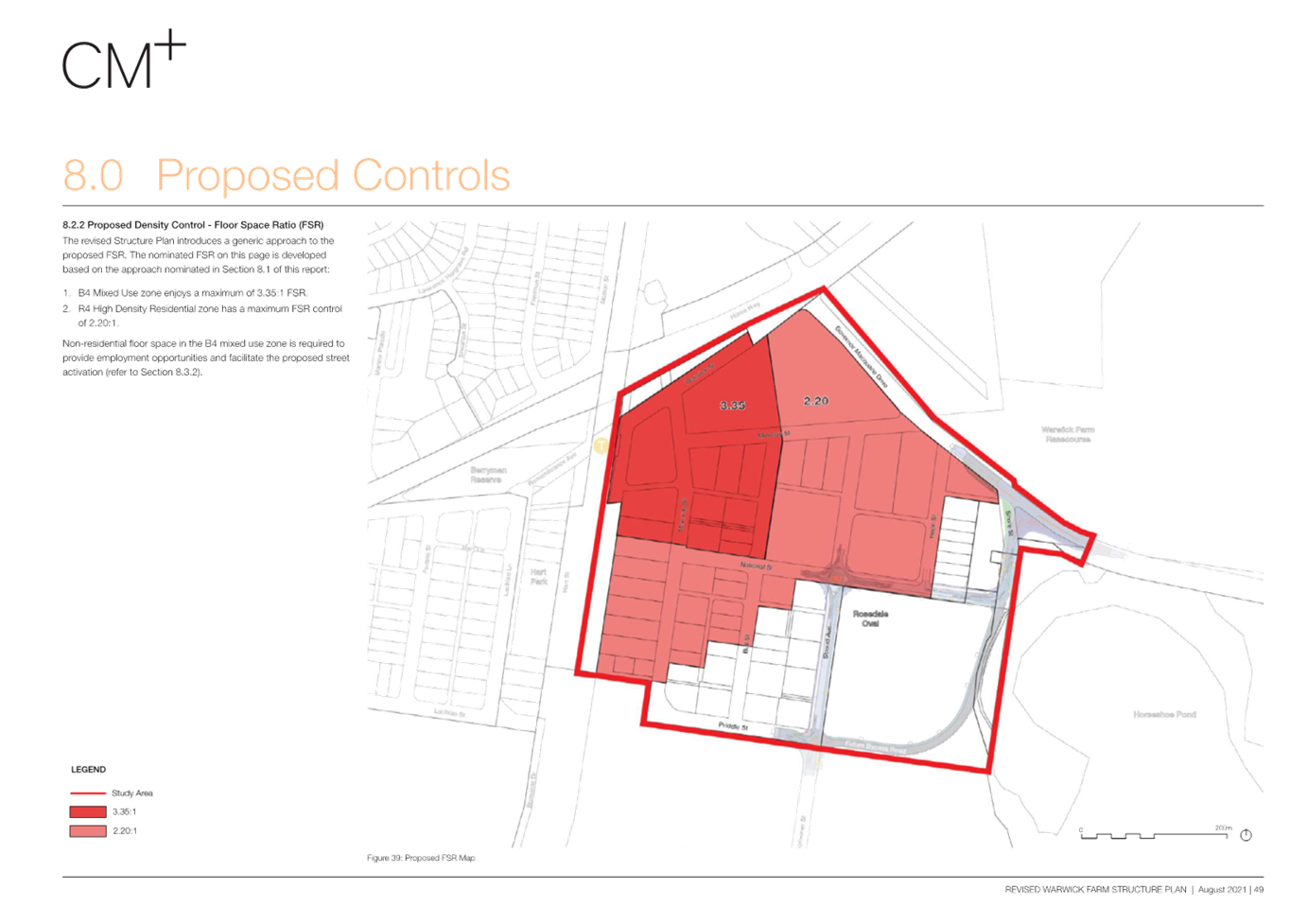
· An overall FSR of 1.04:1 across the entire Precinct
(including open space) with an FSR of 3.35:1 on the Mixed-use Land and 2.20:1
on the R4 High Density Residential Zone.
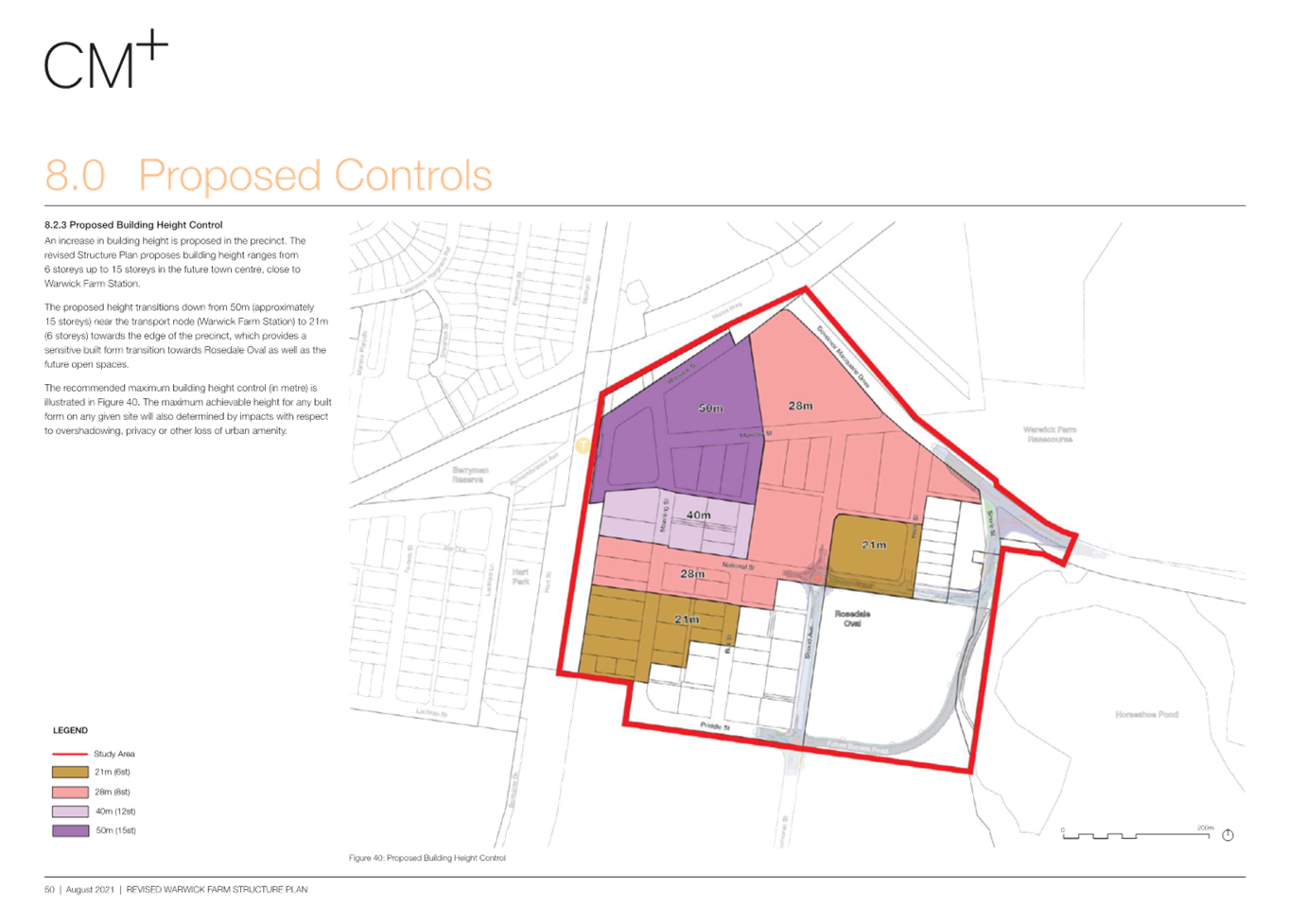
· The tallest development near the station
at 15 storeys generally stepping down to 12, 8, 6 and 4 storeys moving away
from the station.
· Approximately 39,603m2 of
additional open space to supplement the existing Rosedale Oval that will be
delivered as publicly owned land as well as privately owned, but publicly
accessible.
The
most recent Precinct Plan is shown in Figure 3.
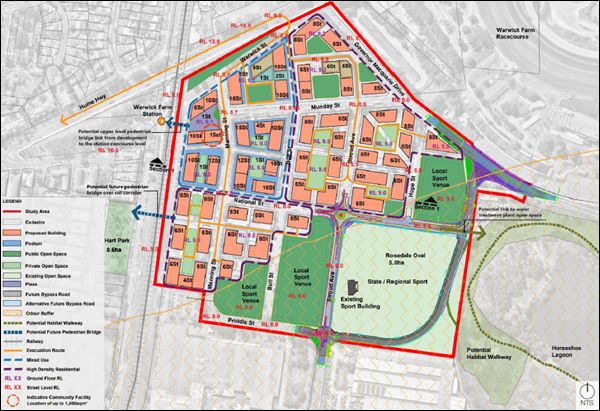
Figure
3: Precinct Plan (Source CM+)
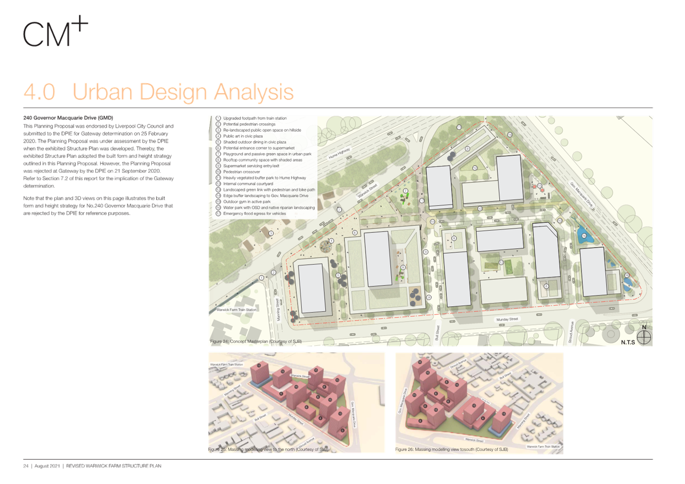
240
Governor Macquarie Drive
On 10 July 2018, Council received a Planning Proposal
request to rezone land at 240 Governor Macquarie Drive, Warwick Farm from B5 Business
Development to part R4 High Density Residential. The Planning Proposal request
also sought to increase the floor space (FSR) development standard from 0.75:1
to 3:1 (equating to approximately 87,900m2 GFA) and the height of
building (HOB) development standard from 15m to 50m and to reduce the minimum
lot size from 2000m2 to 1000m2.
At the Ordinary Meeting of Council on 11 December
2019, Council resolved (EGROW 09), to endorse “in principle” a
Planning Proposal request for 240 Governor Macquarie Drive, Warwick Farm,
subject to the Applicant submitting an amended Planning Proposal Report with
modified floor space ratio of 2:1 or 500 dwellings (with access to the bonus
FSR provisions of up to 3:1), and height of building control of 50m.
On
27 February 2020, Council submitted the Planning Proposal to the DPHI (formerly
Department of Planning and Environment) for Gateway assessment. On 22 September
2020, Council received notification that Council’s request for a Gateway
determination had been refused. Them DPHI cited several reasons for this,
noting that investigations to inform the Warwick Farm Structure Plan, in which
the subject site is located, should be undertaken as a Precinct-wide approach.
As such, it was recommended that this standalone Precinct be rolled into a
consolidated Planning Proposal for the Precinct. 240 Governor Macquarie Drive
was included in the Precinct Plan by Council resolution on 28 April 2021.
More
recently, the landowners of 240 Governor Macquarie Drive have met with Council
staff and are seeking to progress the redevelopment of 240 Governor Macquarie
Drive either as a part of the Precinct, or as a standalone Planning Proposal.
It is understood that the landowners are currently undertaking further design
testing, and traffic modelling to determine the evacuation capacity of the
Precinct.
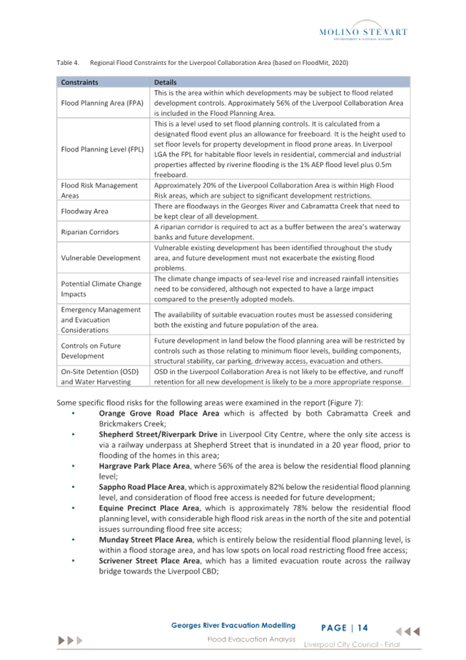
A Development Application (DA-1134/2021) was approved
by the NSW Land and Environment Court on 5 January 2023. The DA proposed:
· ‘Construction of a mixed-use development
comprising specialised retail premises, food and drink premises, a centre-based
child care facility, health services facilities and business identification
signage with associated works including car parking, access, landscaping and
civil work’.
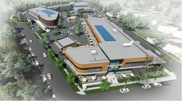
Figure
4: Photomontage of DA-1134/2021 (Leffler Simes Architects)
Part 1: Issues
This
section of the Report details the issues with the draft Precinct Plan and the
constraints of the Precinct, as background information for Part 2 of this
Report which details future options.
A. Strategic Merit
Local Strategic Planning
Statement
Council’s Local Strategic Planning Statement was
endorsed in 2020. Planning Priority 10, ‘A world class health,
education, research and innovation Precinct’ includes aims to support
development of the Liverpool Innovation Precinct and ensure land use planning
supports the operation and growth of the Precinct for all in the health,
education and innovation ecosystem. Specifically, Action 10.2 within the LSPS
states:
“Prepare
structure plan and Planning Proposal to rezone the Warwick Farm reaching
Precinct to a mix of uses including B4” (Updated to MU1 Mixed Use as
per the Employment Zoning Reform).
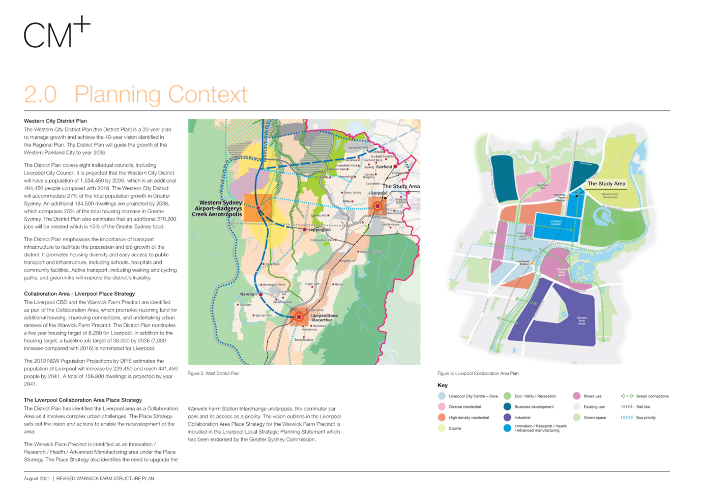
Collaboration
Area – Liverpool Place Strategy
Planning
Priority W2 ‘Working through collaboration’ of the Western City
District Plan includes the Liverpool Collaboration Area, which established a
vision for this area. Within this plan, the Warwick Farm area is identified as
being Innovation / Research / Health / Advanced Manufacturing.
The
intent of the vision for this area is to support the health and education
Precinct of the Liverpool City Centre. Specifically, the vision for this area
is for “a high-tech,
transit-oriented, advanced manufacturing business park that leverages the
growth of the health, education and equine sectors, excluding residential
development” (p10).
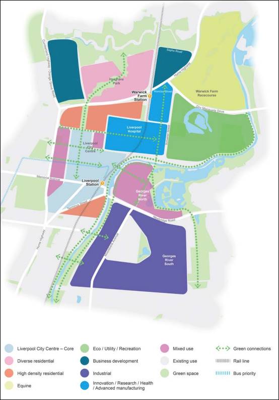
Figure 5: Place Strategy Vision, Collaboration Area
Liverpool Place Strategy
Liverpool
Innovation Precinct
The Precinct is directly east of
the Liverpool Innovation Precinct (pink below), which focuses on Health and
Education delivery in Liverpool.
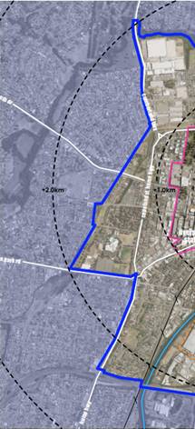
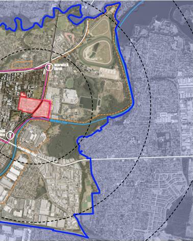
Figure 6:
Liverpool Innovation Precinct (pink)
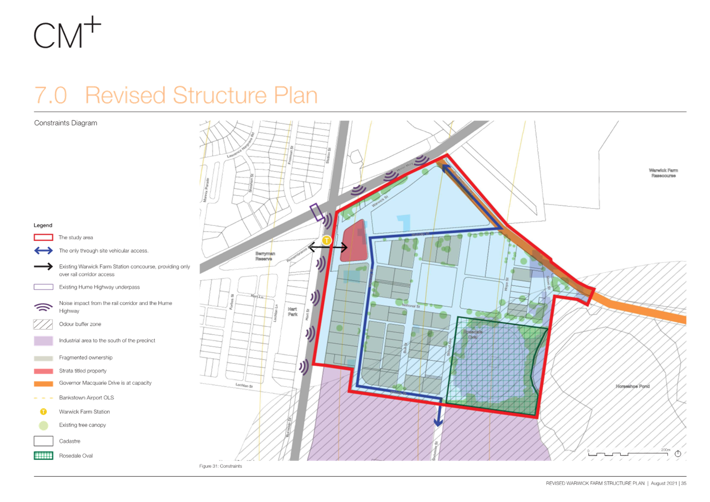
B. Site
Specific Constraints
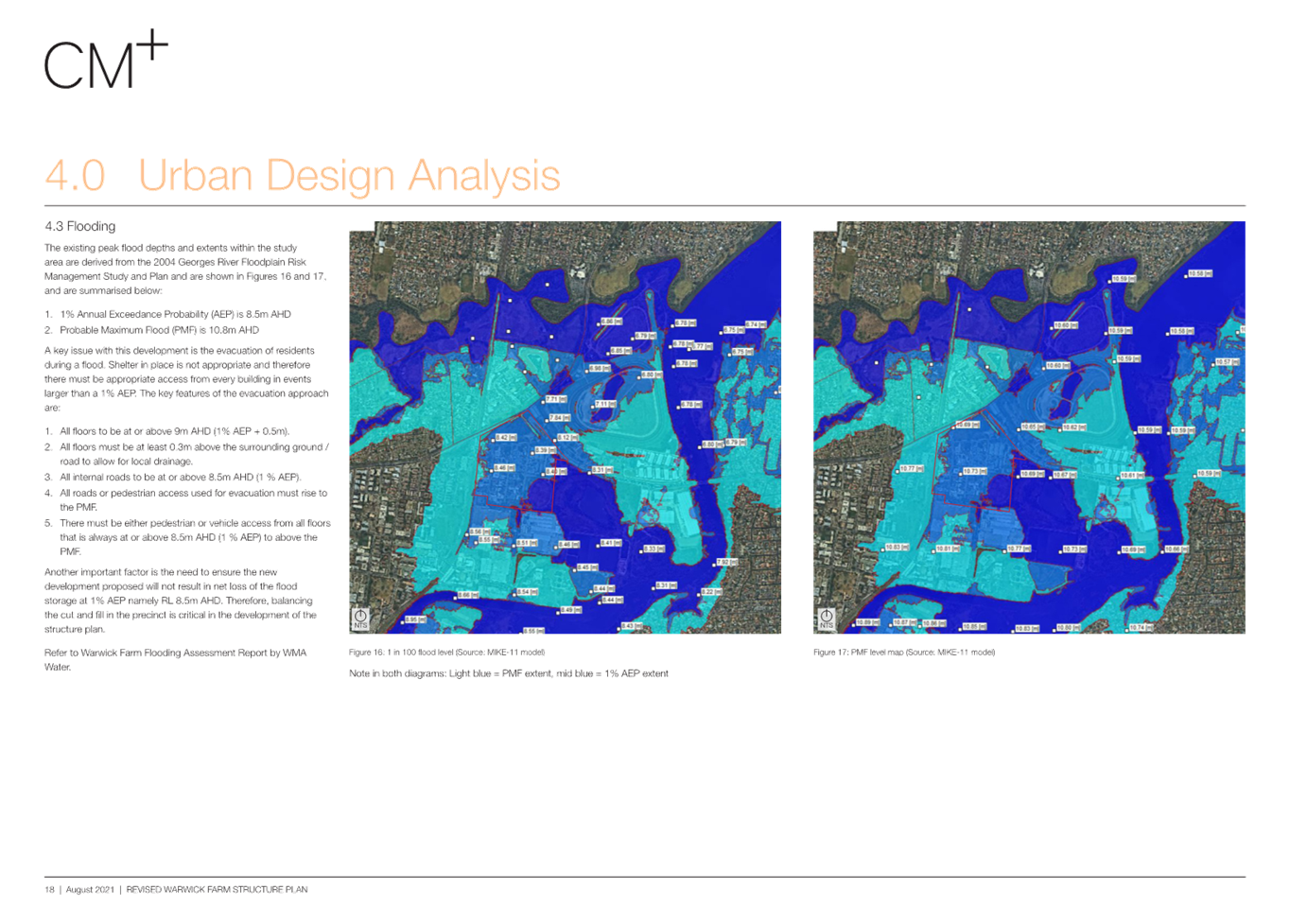
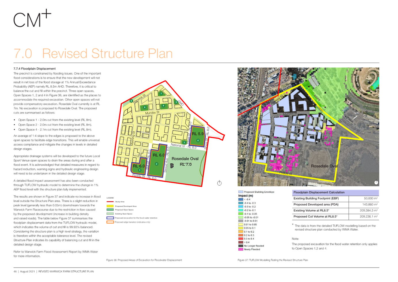
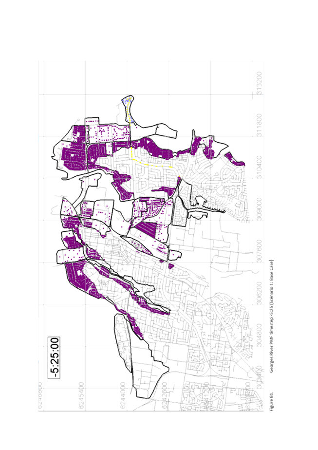
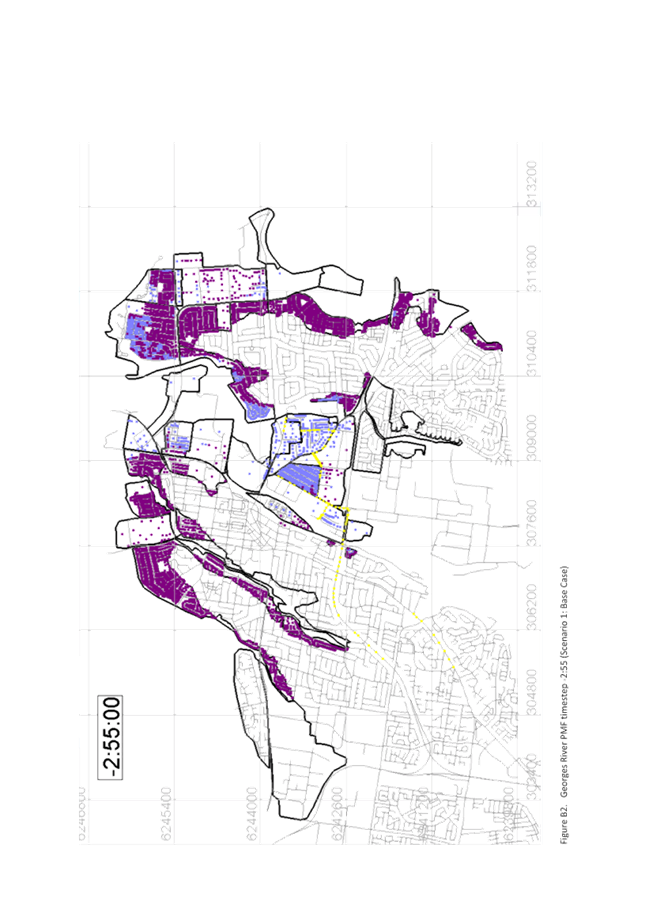
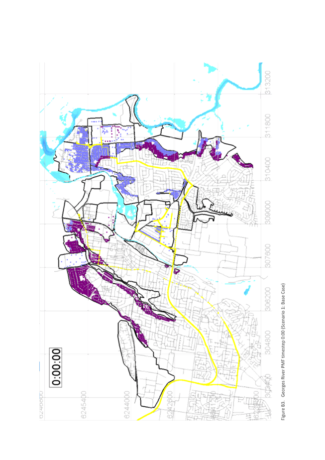
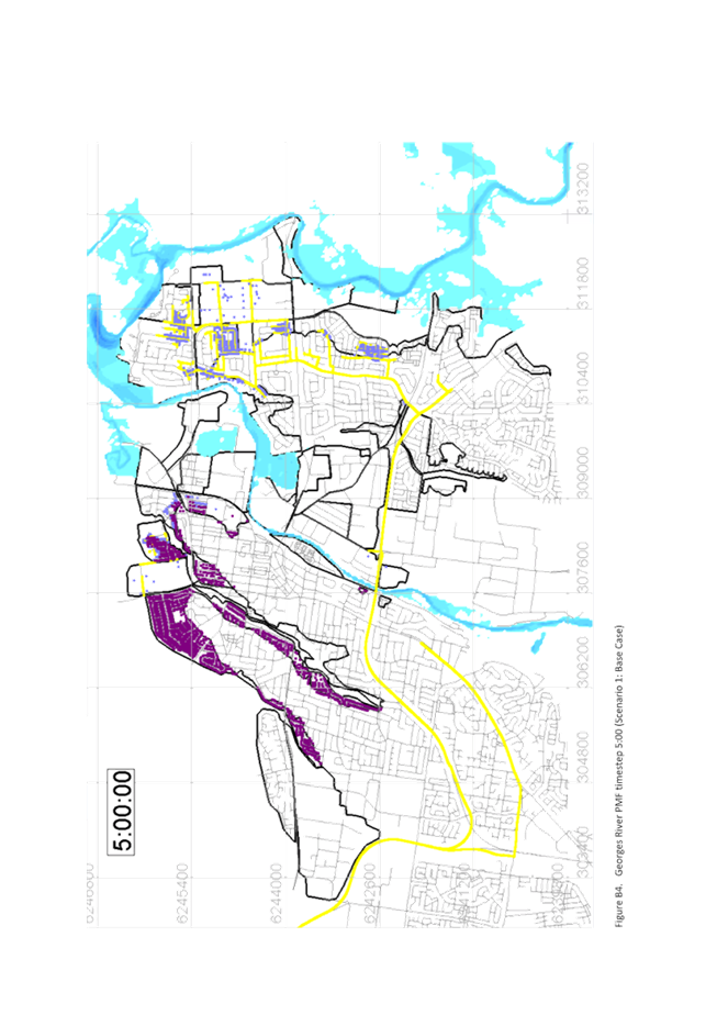
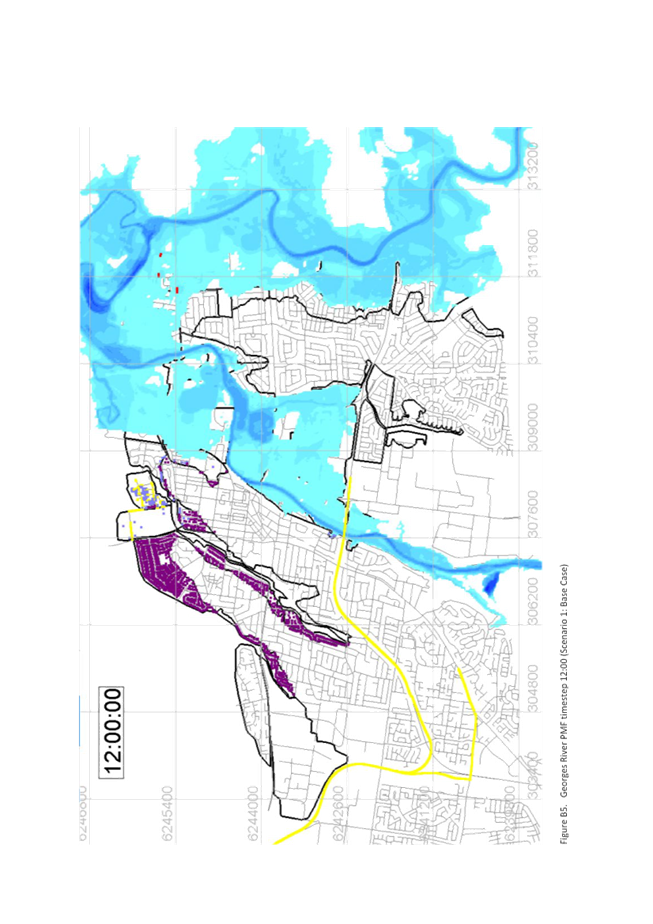
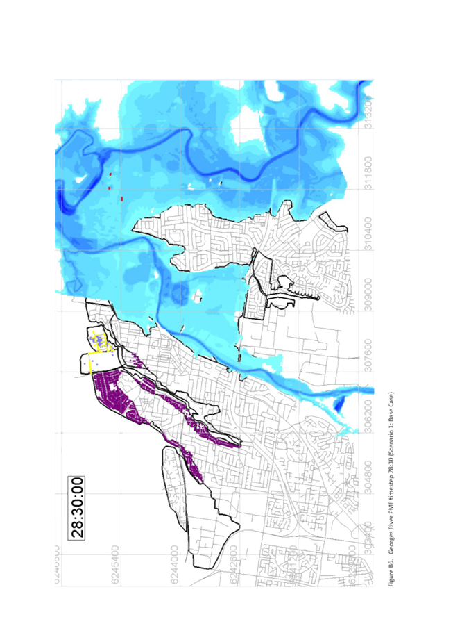
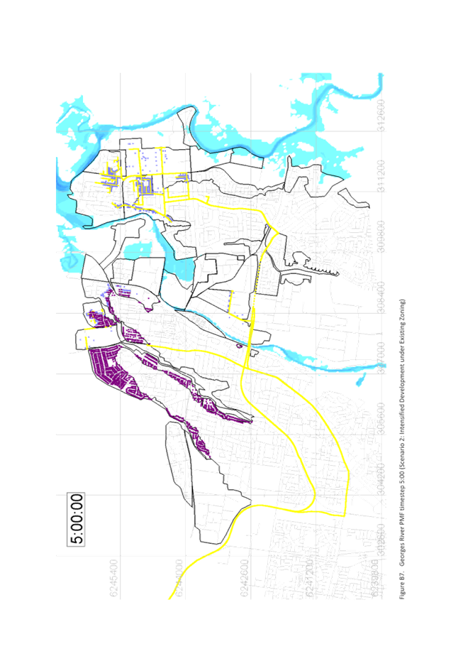
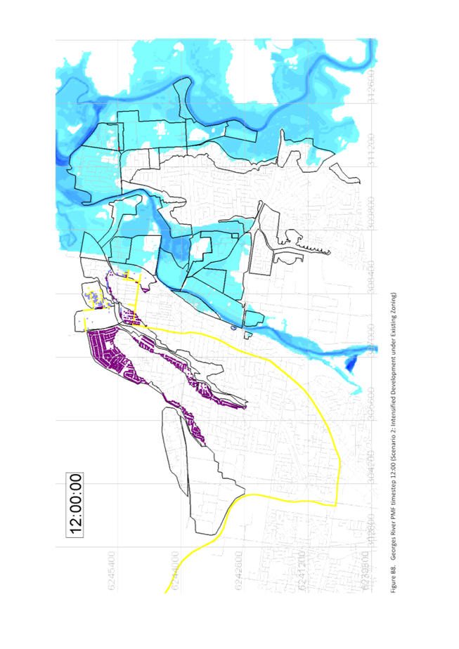
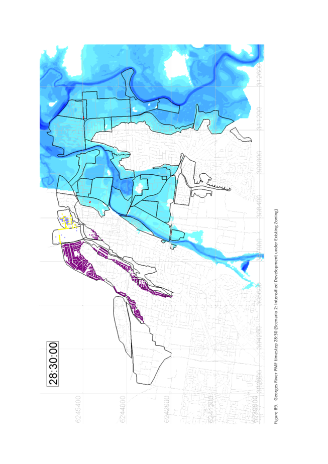
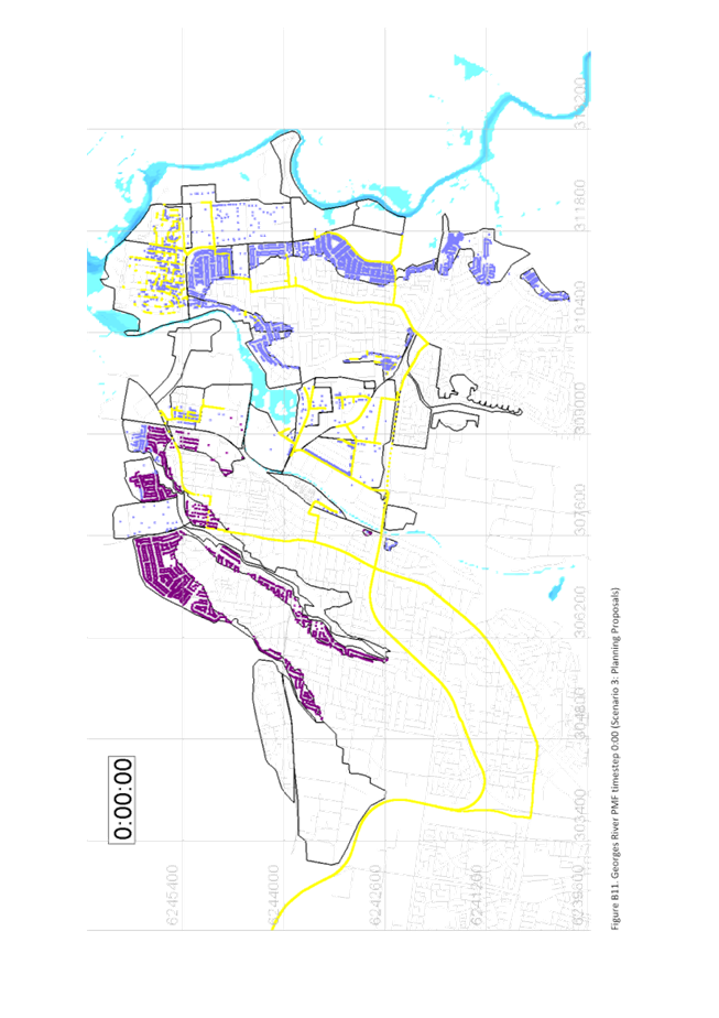
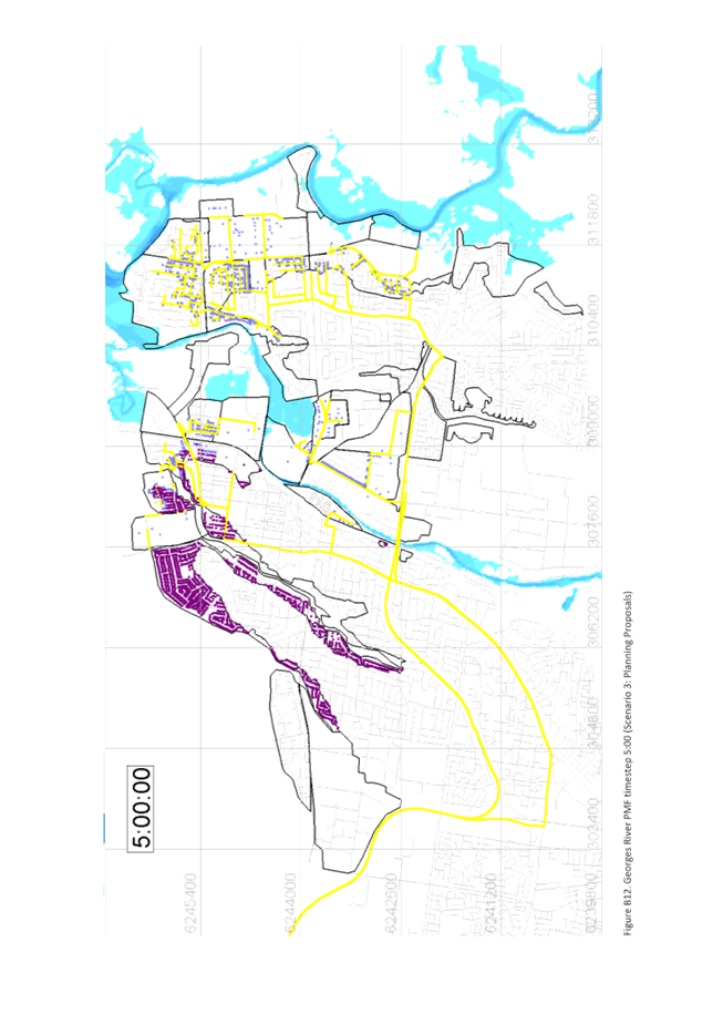
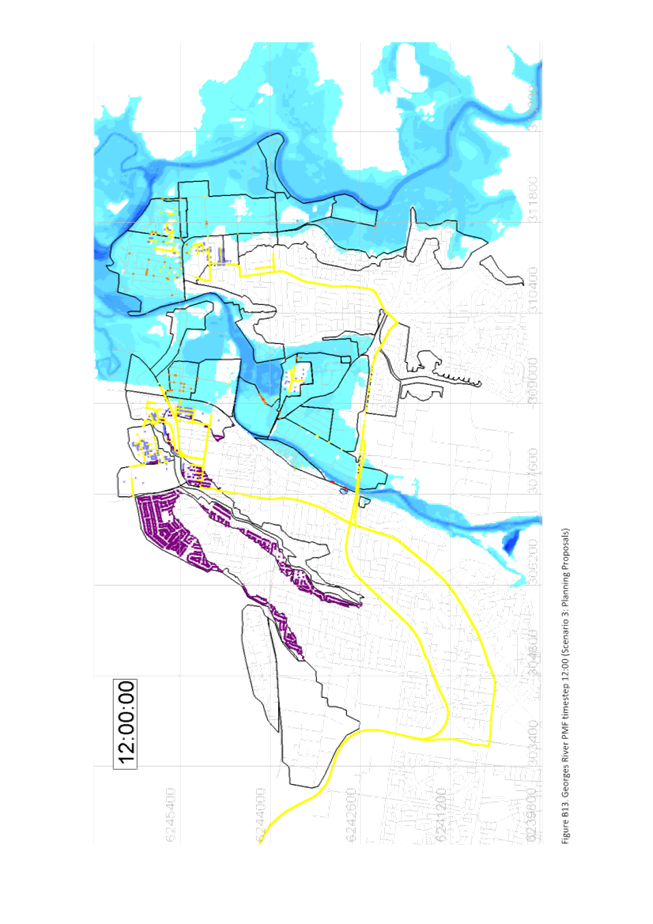
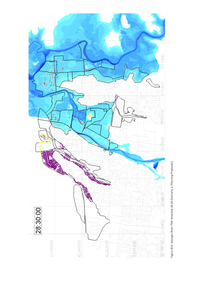
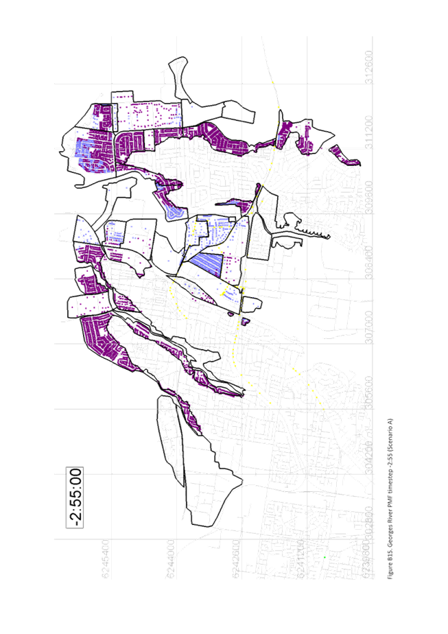
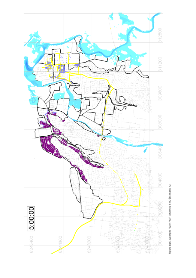
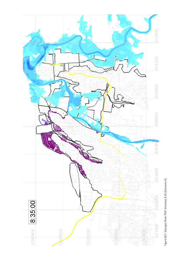
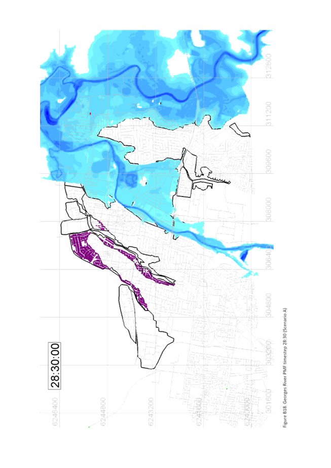
Flooding
The majority of the Precinct is mapped as high and
medium risk flood prone land, with a small portion mapped as low risk (as shown
in Figure 7, below). The site is identified as being prone to flooding
from the Georges River catchment.
The
site is not affected by the 20- year flood but would be inundated by the
100-year flood. Previous flood studies suggested the site would be classified
as being a "medium flood risk" with inundation depth between 0.2m and
0.6m.
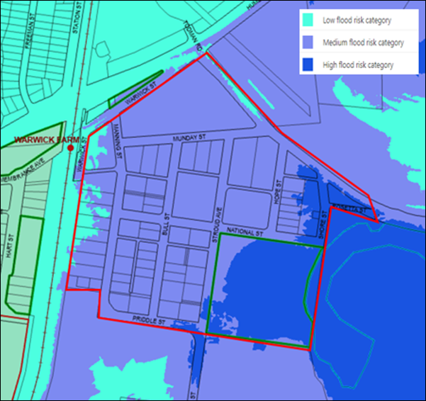
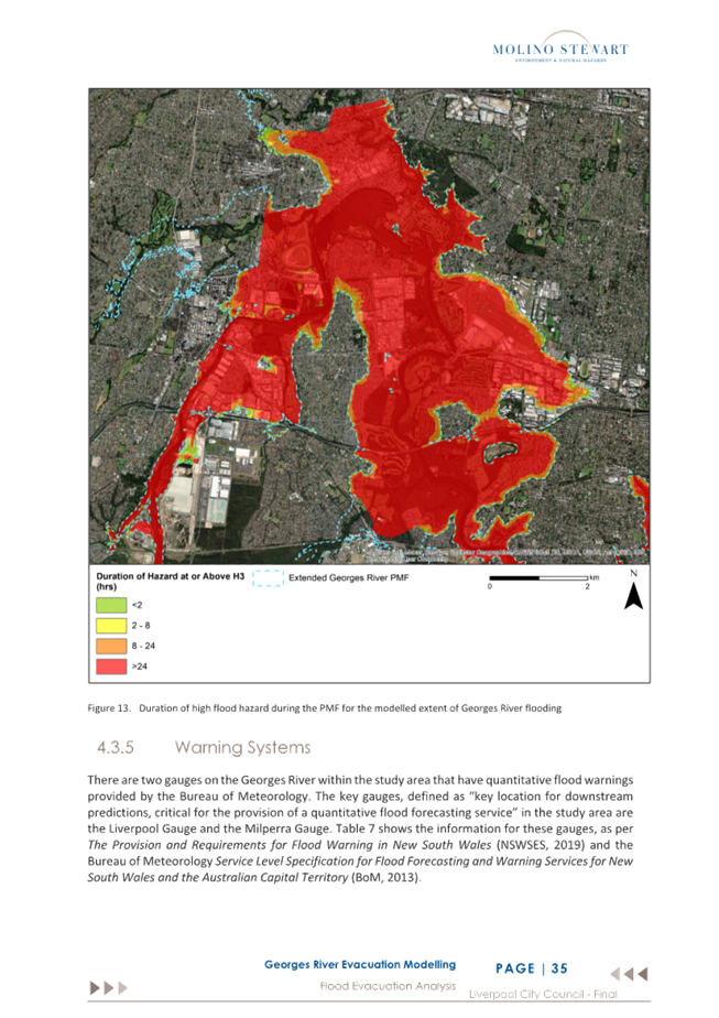
Figure 7: Council internal
Flood Risk mapping
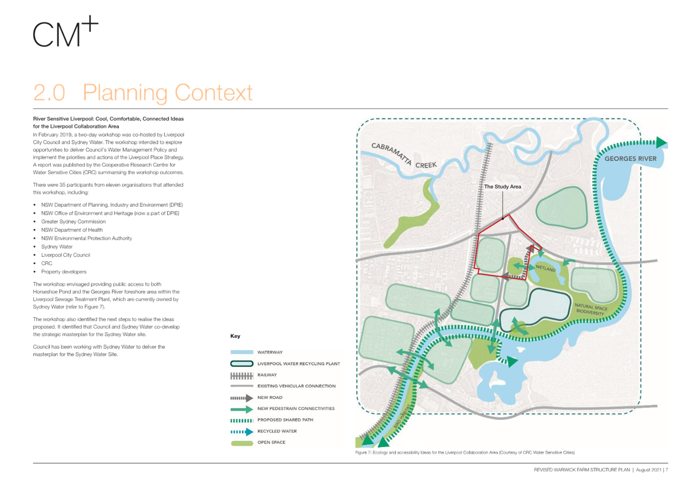
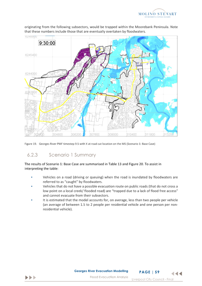
A
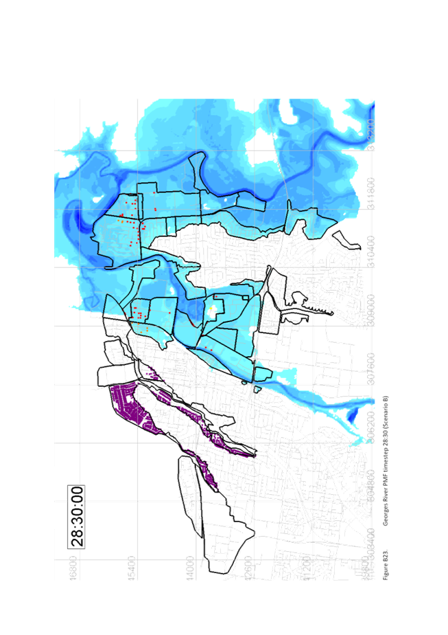
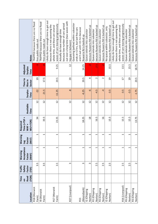
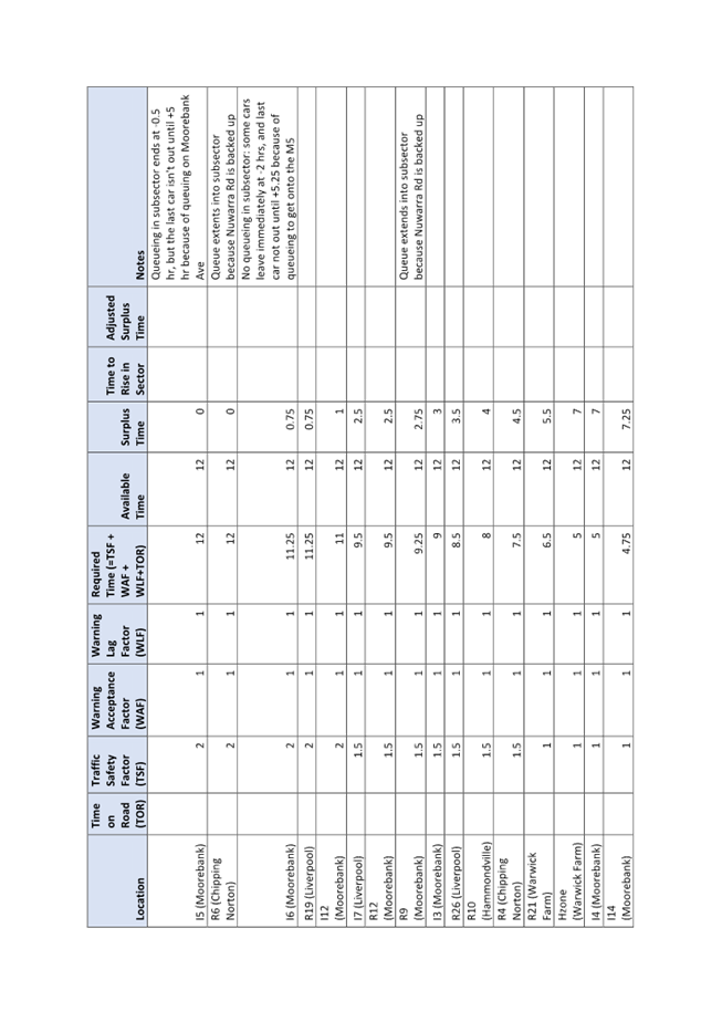
Flood Evacuation Study for the Liverpool Collaboration Area and Moorebank was
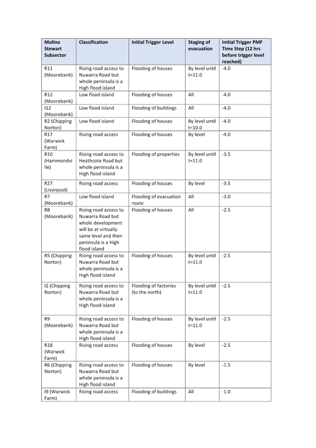
completed in 2022 by Molino Stewart on behalf of Council (Attachment 2).
The study responded to the Liverpool Collaboration Area Place Strategy, which
identified flooding and flood evacuation as potential constraints on growth in
the area. It tested whether premises on the floodplain could evacuate safely
when ordered to by the State Emergency Service (SES) in flooding events up to
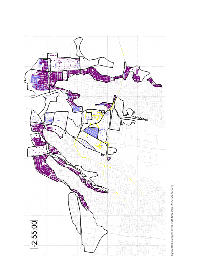
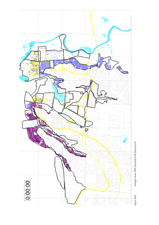
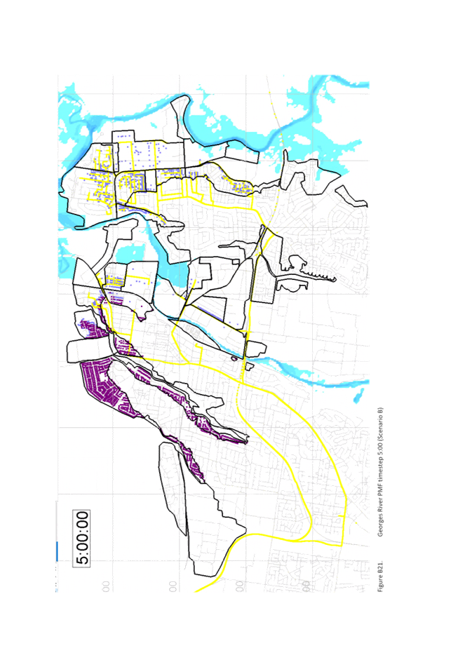
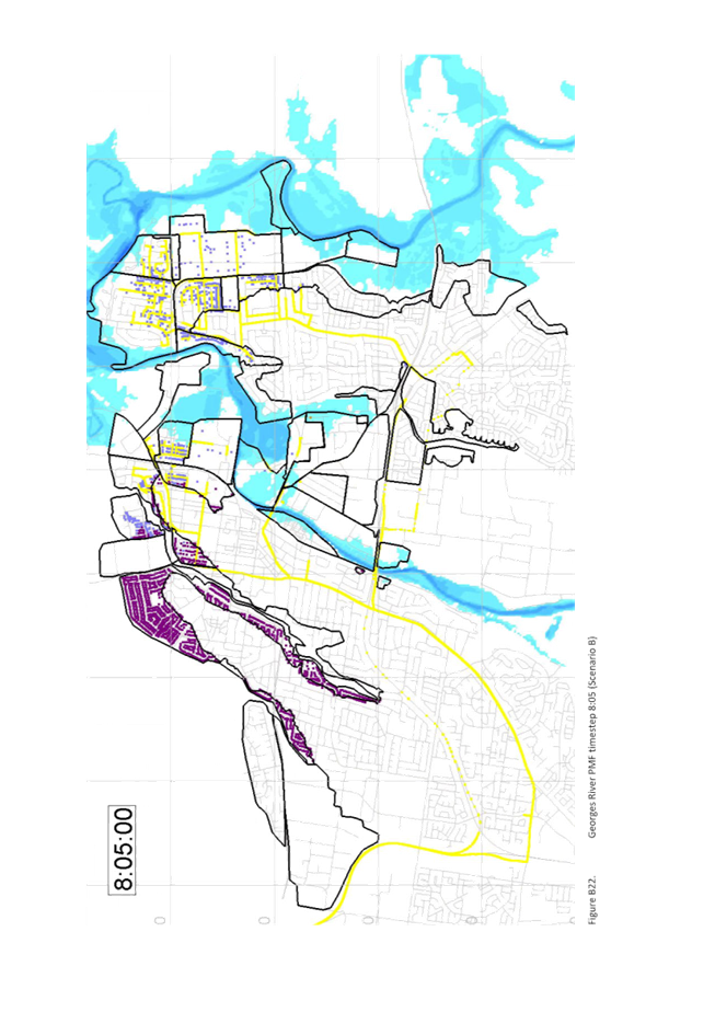
the probable maximum flood (PMF) level.
As
such, the study models road capacity to determine whether development (existing
and proposed) can evacuate within the available flood warning time given a 100%
evacuation compliance rate as required by the SES. The study found that there
is restricted capacity for additional development within the floodplain areas
of the Liverpool Collaboration Area and Moorebank East.
“Spare”
evacuation capacity was investigated at a high level for the large Planning
Proposals. Specifically, the spare capacity for the subject Precinct was
estimated at 864 vehicles. The most recent Precinct Plan for the Warwick Farm
Precinct was estimated to generate 3,709 vehicles.
In
addition, Shelter In Place was determined to be inappropriate for the area, and
every building requires access above the 1% AEP. This is a significant design
consideration and requires balancing significant cut and fill.
‘Ministerial Direction 4.1 Flooding’
states a list of considerations which the Planning Proposal must be meet or be
justifiably inconsistent. Specifically, the Ministerial Direction states, a
Planning Proposal must not contain provisions that apply to flood planning
areas which includes (but not limited to):
· Permit developments in floodway areas;
· Permit development for the purpose of residential
accommodation in high hazard areas;
· Permit a significant increase in the development and
/or dwelling density of that land;
· Permit development for the purpose of centre-based
childcare facilities, hostels, boarding houses, group homes, hospitals,
residential care facilities, respite day care centres and seniors housing in
areas where the occupants of the development cannot effectively evacuate; and
· Are likely to result in a significantly increased
requirement for government spending on emergency management services, flood
mitigation and emergency response measures, which can include but are not
limited to the provision of road infrastructure, flood mitigation
infrastructure and utilities.
The
most recent Precinct Plan would be unable to demonstrate sufficient consistency
with the above-mentioned Ministerial Direction.
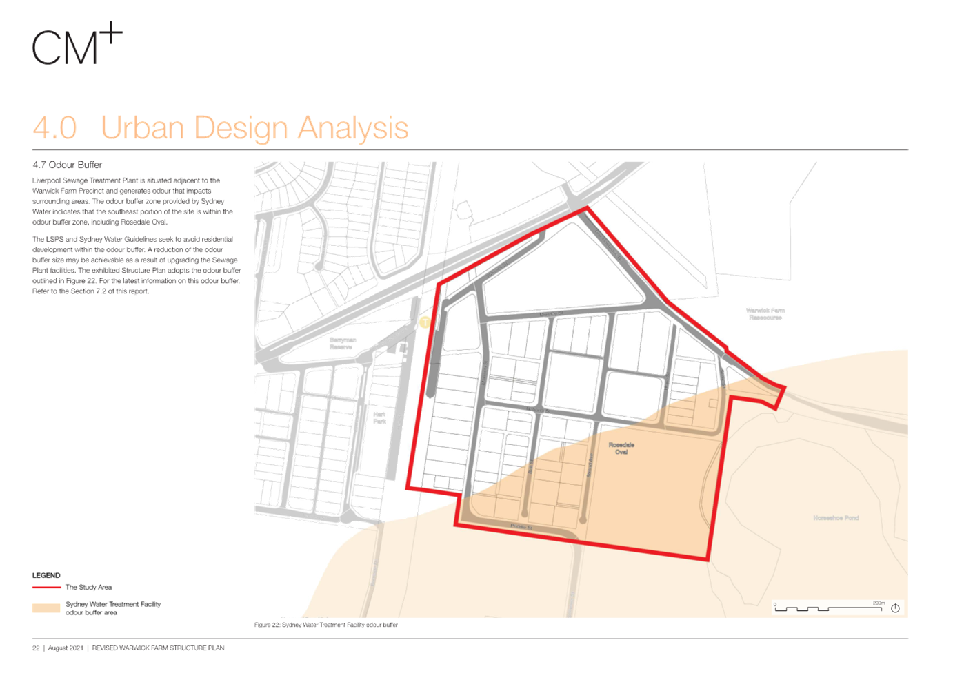
Odour Buffer
The Precinct is affected by an odour buffer which is
identified around the Warwick Farm sewerage treatment works. The buffer zone
aims to reflect areas that may be subject to odour from plant based on
distance, meteorological and topographic conditions. The full extent of the
buffer area can be seen in Figure 8 below.
Since
at least the mid 1990’s Department of Urban Affairs and Planning (now
DPHI) has released policy documents which seek to prevent residential and other
sensitive uses from establishing in the odour buffers around sewerage treatment.
As part of the previous exhibition for the Precinct Plan, Sydney Water raised
concern about any proposals that would increase residential densities within
the existing odour buffer zone. Council designed the subject Precinct Plan with
this in mind.
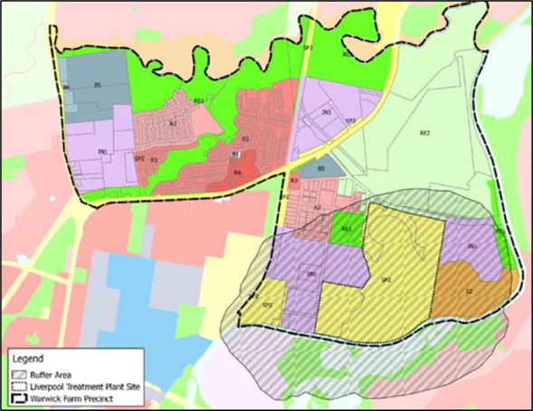
Figure
8: Odour buffer zone with associated sewerage treatments works.
C.
Constraints of the Precinct Plan
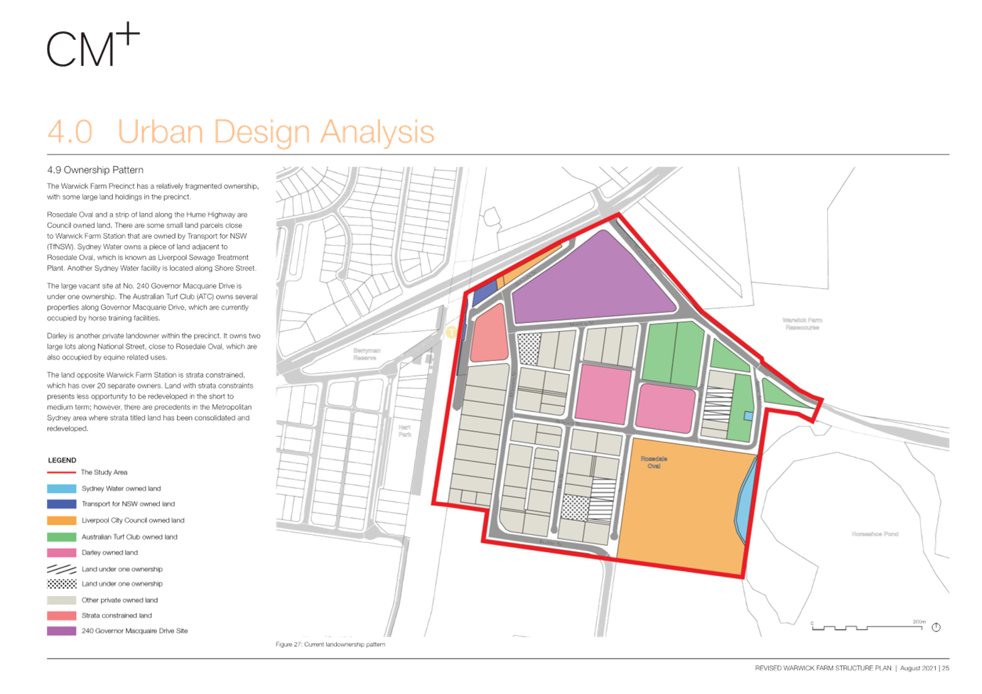
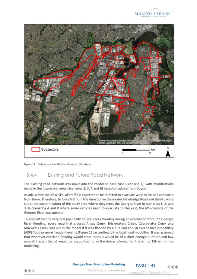
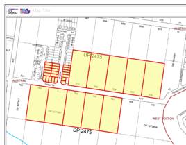
Fragmented
Land
Land within the Warwick Farm Precinct is generally in
fragmented ownership, which further complicates the redevelopment of the
Precinct. The most recent Precinct Plan seeks to encourage re-development by
enabling the consolidation of various fragmented landholding for development,
and the acquisition of land for open space and compensatory storage, however
this increases the complexity of the proposal and negatively impacts the
feasibility of redevelopment occurring.
Figure
9: Land ownership (Source: CM+)
Feasibility
The draft Precinct Plans had high costs associated
with the Precinct due to requirements for consolidation of fragmented land and
required infrastructure to support the development (raising of roads, flood
mitigation works, open space acquisition, truck bypass, and pedestrian links
across the railway).
Economic
feasibility testing has been undertaken which found the financial feasibility
tipping points of 3.35:1 for B4 Mixed Use zone and 2.2:1 for R4 High Density
Residential zone. However, it’s important to note that this feasibility
testing was done in 2021, and there have been significant changes in the
building industry since the study, such as increased material costs, trade
shortages and higher interest rates. The Precinct is anticipated to have a
higher tipping point now.
Contributions
Plan
The Precinct Plan is supported by a draft
Contributions Plan which aims to fund the solutions including flood evacuation
route with flood free development as well as provision of new recreation and
community facilities and address traffic related issues. This would have to be
revisited, and it is likely the contribution rates would increase. A summary of
the proposed contributions rates is shown in the Figure 10.
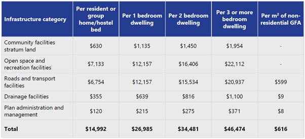
Figure
10: Proposed Contribution Rates
Property
Acquisition / Open Space
To
facilitate future rezoning and redevelopment in the Warwick Farm Precinct as
per the Structure Plan, there is a need to reserve some land for public
purpose, including future open space and flood mitigation. The Precinct Plan
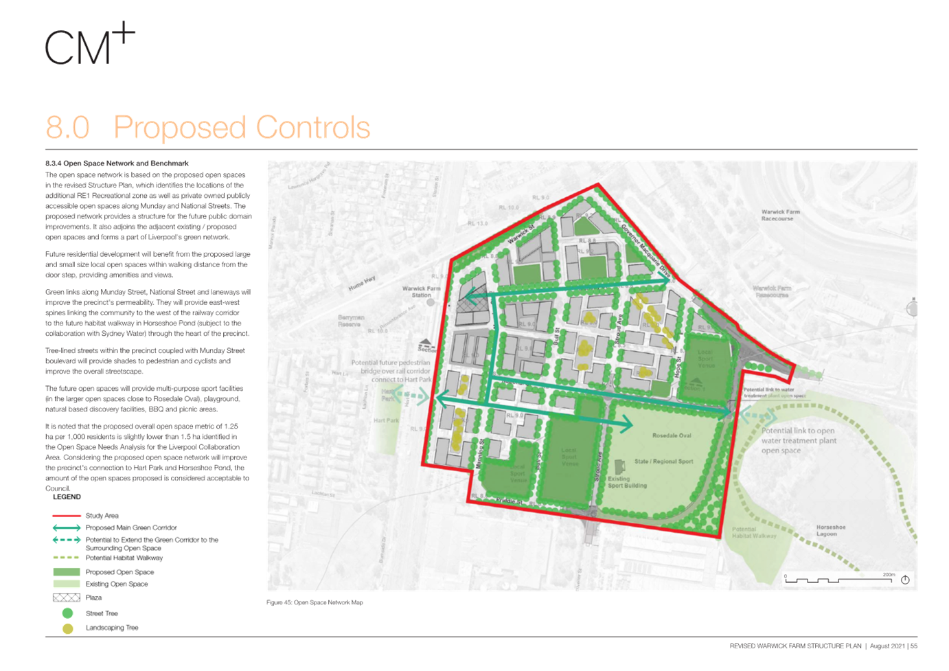
provides for an increase of approximately 39,603m2 of open space to
meet the needs of the future population.
The
larger areas of open space are proposed to be zoned RE1 Public Recreation and
are included in the Contributions Plan for acquisition and embellishment.
Specifically, the Precinct Plan provides the overall quantum of land for open
space which is public or publicly accessible private open space is 1.25ha per
1,000 people which is slightly lower than the 1.5ha per 1,000 people identified
in the Open Space Needs Analysis for the Liverpool Collaboration Area.
The
additional open space is crucial to ensuring the redevelopment provides
sufficient amenity for future residents, however, it does increase the cost to
develop, and requires property acquisition of private land.
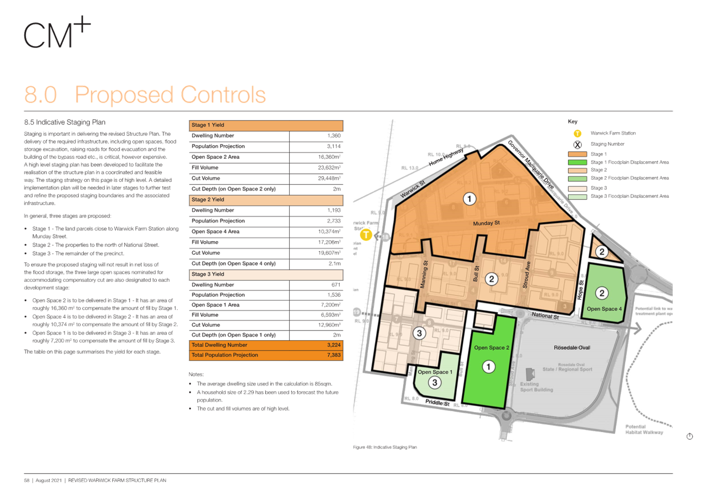
Staging
of the Precinct Plan
Given the flood constraints within the Precinct, and
to achieve a safe evacuation route, it will be necessary to raise key roads
with the compensatory storage being provided within nominated open space areas.
Specifically, the proposed development will need to ensure that the raising of
the roads is included in the Draft Local Contributions Plan as each development
site will need to complete full road construction. This will need to be
undertaken in a staged manner, with sequencing from north to south in order to
provide a continuous evacuation route using the raised roads rising to the
Warwick Street and Hume Highway intersection. The nominated future staging in
the Precinct Plan attempts to minimise interface issues by including whole
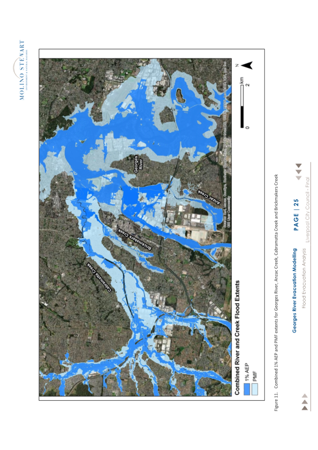
sections of raised road within the stage (see Figure 11 below).
Figure
11: Draft Warwick Farm Precinct Plan - Staging Plan
Traffic
The
road network throughout the Precinct is grid like with the only access points
at Governor Macquarie Drive in the north and Scrivener Street in the south, and
a minor left turn only at Warwick Street connecting to an elevated part of the
Hume Highway overbridge of the rail line in the west. This means the Precinct
carries a high volume of heavy vehicles traffic via Manning and Priddle
Streets. Council has resolved to investigate construction of a road around
Rosedale oval to create a bypass for industrial traffic. A concept design has
been prepared; however, it has not been funded.
The investigation informing the Precinct Plan have
identified the following road intersection works for the Precinct:
· Delivery of a bypass for the industrial area between
Governor Macquarie Drive and Scrivener Street, via Shore Street and a new road
around the Rosedale Oval;
· Conversion of the Governor Macquarie Drive / Shore Street
intersection to a signalised intersection, to connect with the bypass;
· Conversation of the Governor Macquarie Drive / Munday
Street intersection back to a priority intersection due to the proximity to
Shore Street;
· Dualling of Governor Macquarie Drive between Hume
Highway and the Inglis Hotel access road; and
· Implementation of a dual lane right turn bay from Hume
Highway eastbound into Governor Macquarie Drive southound.
Community
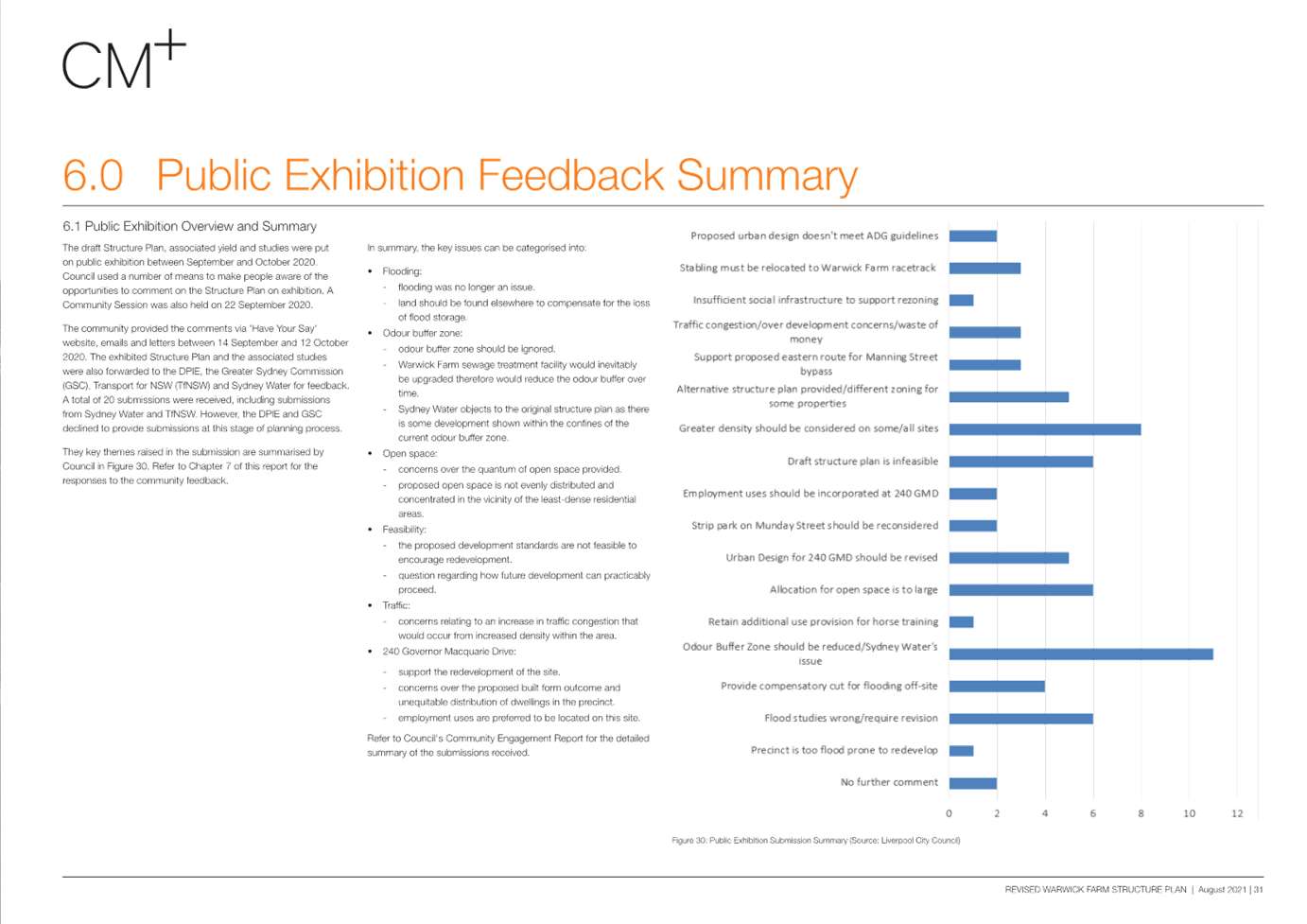
Consultation
The
planning packages have been placed on public exhibition twice, with the initial
public exhibition occurring between 14 September 2020 to 12 October 2020.
During the public exhibition, Council received 20 submissions from the public.
Most of thee submissions supported rezoning the Precinct for high-density
residential uses, however many raised concerns with various aspects of the
Draft Plan.
The
planning package was again placed on public exhibition from 8 October 2021 to 7
November 2021. Council received 26 submissions during the public exhibition. Of
the 26 submissions received, 15 submissions were opposed to the plans and 11
were supportive of rezoning the Precinct in principle, however some raised
issues with several elements of the planning packages and requested changes.
Since
the Structure Plan has been placed on hold, Council staff have received ongoing
calls and enquiries. The enquiries are generally from landowners within the
Precinct seeking an update and/or clarification around the next steps.
Questions in relation to flooding in the Precinct are also common.
Part 2: Options for the Warwick Farm Racecourse Precinct
The
following options are presented to Council to consider how best to proceed with
the Precinct Planning exercise.
Option
1: Proceed with the Precinct Plan prepared by CM+ September 2021 (Not
recommended)
The most recent Structure Plan presented to Council in
November 2021 depicts the redevelopment of the Precinct for mixed use
development including residential development. As outlined previously, the key
features of the Plan includes a total of 294,162m2 of floor space
(274,053m2 of residential GFA, and 20,109m2 of commercial
GFA), creating capacity for approximately 3,224 new residential dwellings.
The proposed zoning map is shown in Figure
12 below:
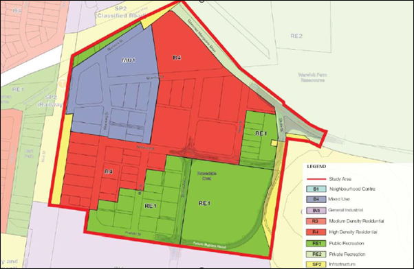
Figure 12: Proposed Zoning under Option #1
(Source: CM+)
Comment:
The
area is significantly constrained in terms of flooding, evacuation, and the
odour buffer. The subject Precinct Plan aimed to mitigate these constraints.
However, this resulted in high costs to develop due to property acquisition and
required significant infrastructure to mitigate the risks of flooding and
evacuation.
In
addition, the approach to addressing flooding in the Structure Plan will mean
that the that increased densities can only be permitted on land which is raised
above the 100-year flood level and that the flood storage will occur within
sports fields and recreation areas required a funded by the increased
development in the draft Contributions Plan. The fragmented nature of the
Precinct makes this extremely difficult.
The
economic feasibility testing for the Precinct was done in 2021, however since
then economic conditions for development have worsened and it is not expected
to have the same feasibility tipping point as previously identified.
Given
the constraints outlined above, and the density sought by the proposed Precinct
Plan, it is considered unrealistic that it would be achieved in full. Flooding
and evacuation are a significant hinderance on achieving the vision of the
plan, and given the risk to life and property, is unlikely to be supported by
the relevant NSW Government Agencies.
If
the Structure Plan was to proceed as is, it would likely result in Council
spending significantly more money to proceed with a plan which would be highly
challenging to implement, and unlikely to be supported by the relevant
NSW Government Agencies.
Option
2: Proceed with Industrial / Innovation Precinct (Recommended)
The
subject Precinct is located approximately 1-1.5km northeast of the Liverpool
City Centre, and located within the Liverpool Collaboration Area, and east of
the Liverpool Innovation Precinct. The Collaboration area aims to target
opportunities for growth in certain sectors including health and education.
This
option would investigate the application of an industrial / business land use
zoned for an innovation Precinct, as per the vision of the Liverpool
Collaboration Area. This would complement the Liverpool Innovation Precinct,
and encourage employment opportunities that support the hospital, and the
Liverpool City Centre.
Options
for this Precinct could include retaining the zoning on 240 Governor Macquarie
Drive, and rezoning the remainder of the Precinct to E4 General Industrial. The
proposed development standards will have to be further investigated.
The
Precinct currently benefits from an additional permitted use under Schedule 1
of the LEP which permits the development of animal boarding or training
establishment, farm buildings and veterinary hospital.
The
E4 General Industrial permits both animal boarding or training and veterinary
hospitals. Farm buildings are not listed as a permissible use but could be
included under Schedule 1 of the LEP for continuity purposes. In addition, a
bonus provision could be added to the Precinct for medical research and
development. This would need to be further analysed.
Comment:
Flood
planning controls are less stringent for industrial and business land uses, and
given the flooding and evacuation constraints, non-residential uses may be
better suited to the area. Whilst a large majority of the subject area is
zoned R2 Low Density Residential, it is not of a general residential nature.
The area is interspersed with several horse boarding and training facilities,
which complements the Warwick Farm Racing Precinct on the northern side of
Governor Macquarie Drive.
There
has been previous studies and strategies that have looked to influence land
changes in this area, with employment uses typically being regarded as being
more compatible with the range of constraints that apply to the area.
Specifically, the Liverpool Collaboration Area Place Strategy (2018) identifies
the area as a high-tech, transit-orientated and advanced manufacturing business
park that leverages from the health, education and equine sectors. The Place
Strategy identifies the area as being in a high performance location which
could make significant economic contributions.
By
rezoning the majority of this area to non-residential use, the odour buffer
would no longer be a significant constraint, because the zoning wouldn’t
permit residential and sensitive uses. This would provide additional
flexibility to the Precinct.
In
addition, rezoning this Precinct to a business / industrial Precinct will
require less investment for infrastructure and would not result the same scale
of open space acquisition. Further analysis would be required to establish if
the staging plan is still required for evacuation purposes.
As
an immediate next step, Council staff can conduct internal investigations and
master-planning to scope the potential yield of the Precinct. This would
include assessing the flood planning controls for industrial land in greater
detail, and if the same amount of infrastructure investment is still required
(staging plan, raising of the roads etc). It is estimated that this exercise
would take approximately 9-12 months. Following further consultation and
endorsement from Council, funding would be requested for further detailed
testing.
It
is anticipated that the final package would require the following documents to
adequately justify the changes: Conceptual Design, Traffic Assessment, Economic
Testing and Feasibility Studies, Detailed Flood Assessment, Open Space Needs
Analysis Precinct Plan, and Contribution Plan. The proposal would also have to
be reported to the Local Planning Panel.
This
option would save Council from allocating significant funds for an outcome that
would unlikely be supported by the NSW Government. It would also provide
landowners with clarity on the future of the Precinct, and consultation would
be required prior to a Planning Proposal endorsement, as per Council’s
Community Participation Plan.
If
Option 2 is supported by Council, additional investigations would be required
to support this option. Therefore, this option would have financial
implications, and require future resourcing, however it is more likely to
result in a positive way forward for the redevelopment of the Precinct.
Additionally, there could be opportunity to partner with the DPHI to develop a
plan that unlocks much needed industrial land to service the wider area.
Option
3: Retain Existing Zoning (Not recommended)
Given
the environmental constraints and development challenges within the Precinct,
Council could retain the existing zoning and development standards. The current
uses complement the Warwick Farm Racecourse and are of local economic
importance. This option would allow for development under the existing zoning,
and not require the significant infrastructure investment to support it.
This
would have no financial implications on Council, however, would not align with
the actions outlined in the LSPS or vision of the Collaboration Area.
Furthermore, existing flooding risks impacting the Precinct would remain.
Choosing
this option may result in criticism from the community, who have participated
in two previous public exhibitions. As previously noted, numerous emails and
calls from residents are received by Strategic Planning, seeking clarification
on how the Precinct will be developed in the future.
There are no financial implications relating to this recommendation.
FINANCIAL
IMPLICATIONS
There
are no financial implications associated with the Report however Council should
note the following indicative financial implications associated with the three
proposed options:
· Option 1 would require various issues to be resolved,
requiring further investigations. So far approximately $300,000 has been spent.
Due to the constraints of the Precinct, it is highly unlikely this option would
be progressed to the point of practicable implementation, even with further
funding allocated;
· Option 2 provides a new vision for the Precinct and
requires new studies to ensure the vision is viable. As an immediate next step,
Council staff could draft a high-level Master Plan which includes potential
development standards, and associated infrastructure needs. Once this was
completed and endorsed by Council, further investigations to support a Planning
Proposal could occur (e.g. Precinct Plan, Traffic Assessment, Economic Testing,
Feasibility Studies, Detailed Flood Assessment, Open Space Needs Analysis,
Contributions Plan and site-specific Development Control Plan). This would be
outside the existing budget allocations for City Planning, and therefore
require further funding. It is estimated approximately $500,000 may be required
to progress this option; and
· Option 3 would have no associated financial
implications.
|
Economic
|
Facilitate
economic development.
|
|
Environment
|
There are no environmental and sustainability considerations.
|
Social
|
There are no social and cultural considerations.
|
Civic Leadership
|
There are no civic leadership and governance considerations.
|
|
Legislative
|
Section 3.31 to 3.37 of the Environmental Planning and Assessment
Act 1979.
|
|
Risk
|
This project is currently at the investigation
stage, so considered to be low risk, and within Councils appetite. There is a
risk of growing community frustration if an option for the redevelopment of
the Precinct is not progressed.
|
1. Attachment
1: Warwick Farm Structure Plan
2. Attachment
2: Georges River Flood Evacuation Modelling Report
3. Attachment
3: Letter to the Minister for Planning and Public Spaces
4. Attachment
4: Response from NSW Government- Deputy Secretary-OBO Minister - NSW Flood
Inquiry 2022
The most recent Warwick Farm
draft Precinct Plan, draft Planning Proposal, draft Contribution Plan, Summary
Fact Sheet, Flood Assessment, Traffic Assessment and Fact Sheet on Property
Acquisition can be found through this link:
https://liverpool.infocouncil.biz/Open/2021/11/CO_20211124_AGN_439_AT_SUP_WEB.htm
Governance
Committee Meeting
9 April 2024
Infrastructure and Planning Committee Report
|
ITEM 03
|
Notice of Motion - Narrow Road Widths
|
|
Strategic Objective
|
Evolving,
Prosperous, Innovative
Implement
planning controls and best practice urban design to create high-quality,
inclusive urban environments
|
|
File Ref
|
356486.2023
|
|
Report By
|
Kweku Aikins - Senior
Strategic Planner
|
|
Approved By
|
Lina Kakish - Director
Planning & Compliance
|
At the Ordinary Meeting of
Council on 27 September 2023, Council resolved (NOM 01) to table a Report at a
future workshop that identifies the challenges, opportunities and cost
implications of the following:
1. The
build and maintenance of current residential narrow street widths when compared
to a new minimum width, increased in width to address the practical needs of our
residents and that includes traffic calming devices that ensures the same
safety concerns as was proposed by making the streets so narrow.
2. Any
increase in the cost of housing as a result of increased residential rtreet
widths in new developments if implemented.
3. Council’s
advice on challenges and appetite to object to the SEPPs that might override
Councils vision to increase the minimum residential street widths, if
implemented.
4. The
current cost to provide in-bay parking in existing and new narrow streets.
Council Officers have provided
responses to each of the queries above. It is recommended that Council receives
and notes these responses.
That the Committee receives and notes the response to the
Notice of Motion (NOM 01) from the Ordinary Meeting of Council on 27 September
2023 regarding Narrow Road Widths.
Background
At the Ordinary Meeting of
Council on 27 September 2023, Council tabled a Notice of Motion (NOM 01)
regarding the delivery of roads across the Liverpool Local Government Area
(LGA) with a narrow carriageway width. The NOM outlined a series of concerns
about narrow road widths in residential areas, in particular concerns about
emergency vehicle access, on-street parking, and traffic flow.
In response to the NOM, Council
resolved to table a Report at a future workshop that identifies the challenges,
opportunities and cost implications of the following:
1. The
build and maintenance of current residential narrow street widths when compared
to a new minimum width, increased in width to address the practical needs of
our residents and that includes traffic calming devices that ensures the same
safety concerns as was proposed by making the streets so narrow.
2. Any
increase in the cost of housing as a result of increased residential street
widths in new developments if implemented.
3. Council’s
advice on challenges and appetite to object to the SEPPs that might override
Councils vision to increase the minimum residential street widths, if
implemented.
4. The
current cost to provide in-bay parking in existing and new narrow streets.
This Report provides a formal
response to these four items.
Analysis
The following Section provides an
analysis of the four items listed in the NOM from the Ordinary Meeting of
Council on 27 September 2023.
Item 1 – The build and maintenance of current residential narrow
street widths when compared to a new minimum width, increased in width to
address the practical needs of our residents and that includes traffic calming
devices that ensures the same safety concerns as was proposed by making the
streets so narrow.
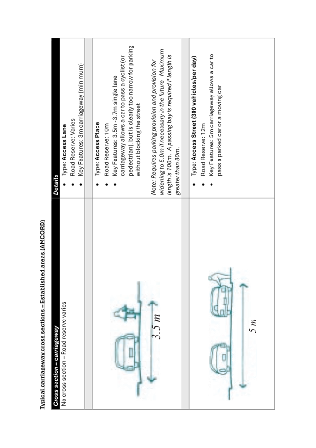
Established Areas
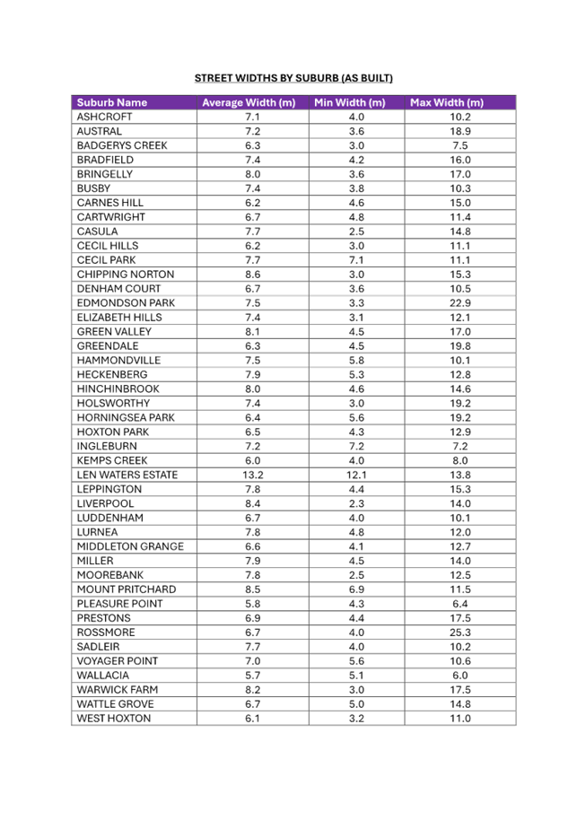
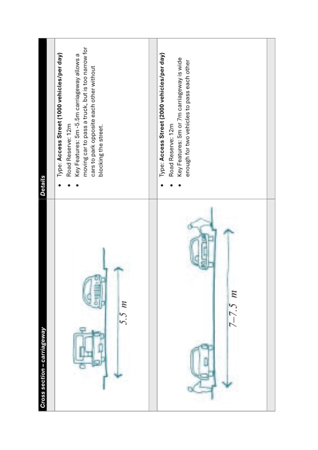
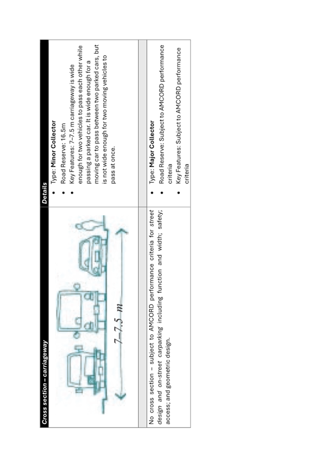
A
suburb-by-suburb breakdown of constructed roads in the LGA (Attachment 1)
has found that average carriageway widths in residential areas vary
from approximately 5.7m to 8.5m.
Narrow
streets are typically found in older release areas such as Wattle Grove and
Prestons and are typically the result of best practice at the time (Australian
Model Code of Residential Development (AMCORD), Commonwealth of Australia,
1995) (Attachment 2).
Providing a
narrow carriageway whilst allowing on-street parking supports lower vehicle
speeds, which in turn improves safety, particularly for more vulnerable users
like pedestrians and cyclists, and enhances local amenity.
However, with
the Liverpool LGA experiencing higher levels of car ownership compared with the
Greater Sydney average – 2021 Census data indicates that 56 per cent of
households within the Liverpool LGA had access to two or more vehicles compared
with 46 per cent for Greater Sydney – competition for on-street parking
in established areas can often be greater than was envisaged by the AMCORD
Guidelines.
By not
providing dedicated on-street parking areas, some narrow streets can become
restricted to a single trafficable two-way lane, impacting vehicular
accessibility. In response to these issues, Council has allocated an annual
budget of $200,000 to implement parking treatments within narrow streets.
The cost of
complete reconstruction of such roads in established areas would be
prohibitively expensive, and impact established infrastructure within the road
reserve like footpaths, street lighting, and street trees, and likely
necessitate services (e.g. electricity, stormwater, telecommunications, water,
etc.) relocation.
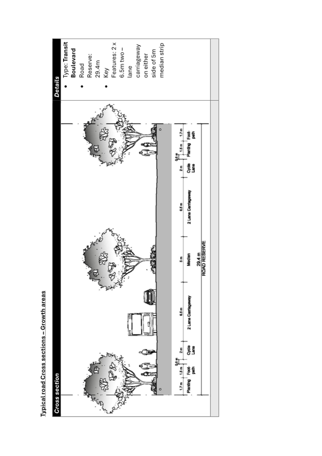
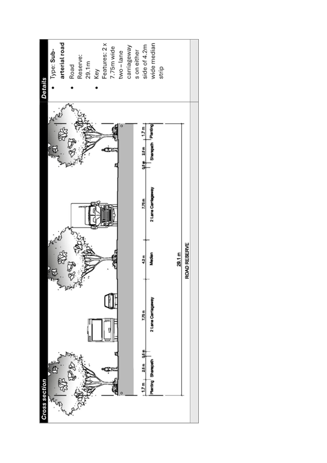
Growth
Areas
In 2021, the Liverpool
Growth Centre Precinct Development Control Plan (DCP) was amended to
enhance traffic flow and alleviate issues associated with the absence of
dedicated on-street parking in local streets. The DCP amendment included
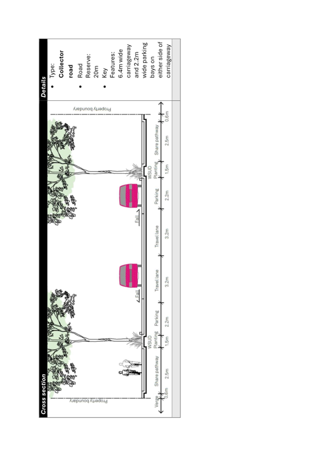
changes to the road cross-section for local streets as shown in Figure 1 (Attachment
3), which were subsequently endorsed by Council at the Ordinary Meeting of
Council on 31 March 2021.
The
amendments maintained the corridor width of a local street at 16 metres (from
property boundary to property boundary) however readjusted the cross-section to
include on-street parking on both sides of the street. The change ensured that
no additional land was required for the purpose of local road construction, nor
any impact to the original dwelling yield.
Conclusion
With the DCP amendment in 2021
ensuring new local streets in growth areas are delivered with on-street parking
on both sides of the street, as well as a trafficable carriageway width that
facilitates two-way traffic flow, it is noted that the existing concerns with
narrow streets in the established areas should be avoided in the growth areas
as they develop.
With regards
to the established areas, given the prohibitive cost of attempting to retrofit
all narrow streets across the LGA, it is recommended that Council continues to
utilise the existing annual budget allocation to target high-risk narrow
streets to address on-street parking issues.
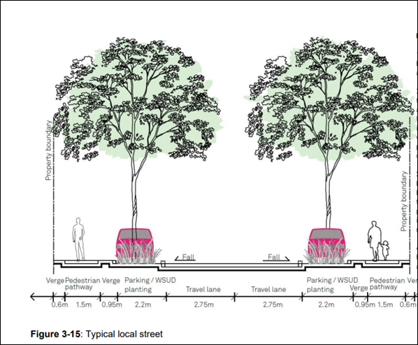
Figure 1: Cross section of typical local street in the Liverpool
Growth Areas (Austral and East Leppington)
Item 2 – Any increase in the cost of housing as a result of
increased residential street widths in new developments if implemented.
It is
acknowledged that there would likely be an associated increase in construction
cost as a result of providing a wider road carriageway for a local street, due
to the inclusion of indented parking bays, associated traffic calming devices,
and a wider trafficable pavement overall. Whether this increase in construction
cost for a wider local street would translate to an increase in the cost of
housing for homes serviced by that street is unclear.
There is no
distinct correlation between increasing local road widths and the cost of
purchasing housing. Whilst the cost of delivering land and housing may
fluctuate based on construction costs and land values, the cost of buying
housing is more related to the cost of comparable dwellings in the area and
factors such as the buyer’s ability to pay and/or to seek debt.
Nonetheless, if road widths are increased, this will proportionally reduce the
saleable land that could be developed on larger sites in the growth areas.
Item 3 – Council’s advice on challenges and appetite to
object to the SEPPs that might override Councils vision to increase the minimum
residential street widths, if implemented.
Road widths across the Liverpool
LGA are governed by Development Control Plans (DCPs) and relevant technical
guidelines, rather than State Environmental Planning Policies (SEPPs).
As such, it is unlikely that a
SEPP would override initiatives to widen local streets. SEPPs will generally
only provide land-use zoning reservations for arterial or sub-arterial roads
which are normally delivered by Transport for NSW.
Item 4
– The current cost to provide in-bay-parking in existing and new narrow
streets.
The cost of providing on-street parking bays is estimated at between $3,000
and $5,000 per parking space. There are two types of parking bay sizes:
· Half
width paved parking bay – meaning one tyre on the road and another on the
footpath verge. Estimated Cost: Between $3,000 and $3,500.
· Full
width paved parking bay - meaning entire vehicle will be parked on footpath
verge. Estimated Cost: Between $4,500 and $5,000.
Conclusion
This Report
details the challenges, opportunities and costs associated with narrow streets
in both established and growth areas across the Liverpool LGA. It is
recommended that Council notes and receives the responses provided in this
Report.
There are no financial implications
relating to this recommendation.
|
Economic
|
Deliver
and maintain a range of transport related infrastructure such as footpaths,
bus shelters and bikeways.
Deliver
a high-quality local road system including provision and maintenance of
infrastructure and management of traffic issues.
|
|
Environment
|
Promote
an integrated and user-friendly public transport service.
Support
the delivery of a range of transport options.
|
Social
|
Regulate
for a mix of housing types that responds to different population groups such
as young families and older people.
|
Civic Leadership
|
There are no civic leadership and governance considerations.
|
|
Legislative
|
There are no legislative considerations relating to this report.
|
|
Risk
|
There is no risk associated with this report.
|
1. Average
street widths by suburb
2. Typical
road cross sections (Established Areas - AMCORD)
3. Typical
road cross sections (Growth Areas)
Governance
Committee Meeting
9 April 2024
Infrastructure and Planning Committee Report
|
ITEM 04
|
Community Participation Plan Discussion
Paper
|
|
Strategic Objective
|
Healthy,
Inclusive, Engaging
Communicate,
listen, engage and respond to the community by encouraging community
participation
|
|
File Ref
|
064679.2024
|
|
Report By
|
Brianna Van Zyl -
Senior Strategic Planner
|
|
Approved By
|
Lina Kakish - Director
Planning & Compliance
|
At the Ordinary Meeting of
Council on 7 February 2024, a Question with Notice (QWN 01) by Councillor
Rhodes was raised regarding neighbour notification of subdivisions resulting in
lot sizes greater than 300m2 (Attachment 1). In response to
the QwN, Council resolved:
‘That:
1. Council take this item to a
Governance Committee before the end of March 2024 so that Council can give this
the attention it deserves to make sure that people are being given equal rights
and are not being discriminated based on the size of the lots being subdivided
in regards to Community Participation Plan 2022 with
the intention of fairer notification for all residents.
2. Further information is
provided on State Government process as it relates to Council process.’
This Report has been prepared in
response to the Council Resolution and details the most recent revision to the
Community Participation Plan (2022), the justification around the notification
requirements for subdivisions of lots greater than 300m2.
The aim of this Report is to
facilitate discussion on the current Community Participation Plan (CPP) and
identify whether any further amendments to the CPP are required. If further
amendments are required, they will tabled at a future Ordinary Meeting of
Council for Council consideration and endorsement.
That the Committee receives and note this Report.
Background
In March 2018, changes to the Environmental Planning and Assessment
Act 1979 (EP&A Act) required all Councils to prepare a Community
Participation Plan (CPP). As a result of the legislative change, Council
subsequently endorsed the Liverpool Community Participation Plan in October
2019.
Before
Council’s first CPP, all community participation requirements were
outlined in Councils Development Control Plan (DCP). Whilst preparing the CPP,
most of the public participation requirements were largely adapted from Part 1
(Chapter 18) of the DCP, including the provision to not require notification of
Development Applications which propose to subdivide lots greater than 300m2.
Part 1, Chapter 18 of the DCP has since been revoked.
More recently, in December 2022, Council endorsed an amendment to the CPP
which made the following changes to the document:
· Updating
land use definitions to reflect the Standard Instrument;
· Removal
of the requirement to advertise in the local newspaper as they have ceased
being published;
· The
addition of a figure which demonstrates the relationship between strategic
documents;
· The
addition of a clause which gives the Manager Development Assessment discretion
to exhibit any application considered to have significant community interest
for a longer period;
· The
addition of a clause requiring Council-related Development Applications to be
exhibited for a minimum of 28 days;
· Increase
the notification distance to five properties in each direction, with Figure 2
being updated to reflect this (request from Council); and
· Amend
notification requirements to include owners and occupiers (request from
Council).
At the
Ordinary Meeting of Council on 7 February 2024, a Question with Notice (QWN 01)
was raised regarding neighbour notification of subdivisions resulting in lot
sizes greater than 300m2 (Attachment 1). In response to the
QwN, Council resolved:
‘That:
1. Council take this item to a
Governance Committee before the end of March 2024 so that Council can give this
the attention it deserves to make sure that people are being given equal rights
and are not being discriminated based on the size of the lots being subdivided
in regards to Community Participation Plan 2022 with
the intention of fairer notification for all residents.
2. Further information is
provided on State Government process as it relates to Council process.’
Analysis
At the Ordinary Meeting of Council on 7 February 2024, the following
items were discussed in relation to the CPP. Responses to each item is provided
below.
a) Notification
of lots greater than 300m2
Notification requirements in the CPP were
largely sourced from the former Liverpool DCP 2008, which did not require the
notification of Development Applications for subdivision of sites greater than
300m2. This same position was carried over into the CPP.
The
subdivision of lots greater than 300m2 typically have less of an
impact on neighbouring properties compared to smaller lot subdivisions (i.e.
less than 300m2). Part of the reason for this is that smaller lots
typically contain development with smaller setbacks and greater potential for
visual, privacy or overshadowing impacts. Conversely, larger lots typically
allow for more flexibility in design, which helps address privacy and amenity
concerns.
In
addition, under SEPP (Exempt and Complying Development Codes) 2008, a
dwelling house can be constructed through the complying development pathway if
the lot is greater than 200m2. Therefore, the decision not to notify
the subdivision of lots greater than 300m2 was because a dwelling
house could be achieved comfortably on the site through a Complying Development
Certificate (CDC) which did not warrant detailed community consultation.
There
is scope to increase the neighbour notification requirements to include the
subdivision of lots greater than 300m2 however this would add an
additional step in the Development Application assessment process for larger
subdivision proposals, as well as increase the associated Development
Application approval timeframes for these proposals.
b) Notification
of five (5) properties in each direction
As part of the amendment to the CPP in
December 2022, the notification distance for some Development Applications were
increased to require notification of five (5) properties on each side of the
subject site rather than adjoining neighbours, as requested by Council. For
clarity, the previous notification requirements are outlined in Figure 1, with
the updated (current) version shown in Figure 2.
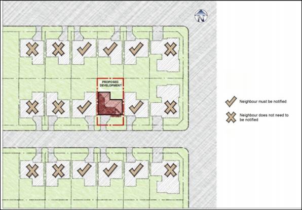
Figure 1: Previous notification requirement under CPP
2019
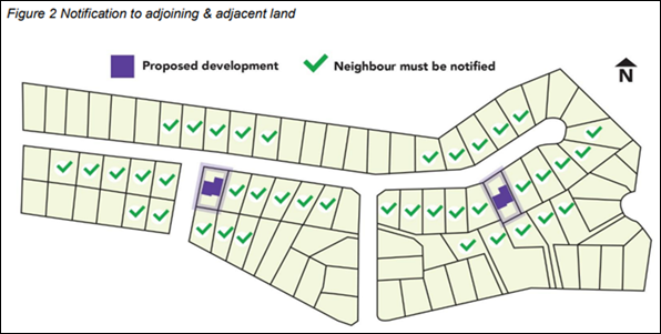
Figure 2: Current notification requirements as per
December 2022 CPP
As a result of this change, Council staff have been
required to send out significantly more letters for Development Applications such
as (but not limited to): Light Industry, Manor Houses, Terraces, Semi-Detached
housing, Commercial Premises and Secondary dwellings.
The requirement to notify five (5) properties in each direction
has resulted in a greater number of notification letters being sent for
relatively minor applications, especially in the rural areas of the LGA. Two
examples of recent Development Applications which have resulted in a
disproportionate number of letters being sent to residents, are presented in
Table 1 below.
Table 1: Examples of Notifications for Development
Applications
|
Development Application
|
No. letters sent
|
Notification Plan
|
|
DA-195/2023
Alterations
and additions to an existing unauthorised structure (granny flat) and change
of use to a secondary dwelling with a proposed attached outbuilding.
|
48
|
|
|
DA-145/2023
Two
lot subdivision, and construction of semi-detached dwellings.
|
46
|
|
The requirement to notify five (5) properties in each
direction has also increased the resourcing associated with neighbouring
property notification. A comparison of Bing Invoices, (the provider Council
uses to conduct mail merges and send letters), from 2022 (prior to CPP changes)
compared to 2023, shows the new notification requirements have resulted in an
increase in overall costs (see Table 2).
Furthermore, Bing has recently advised Council that
from 3 April 2024, each small letter will be subject to a 25c price increase.
Table 2:
Comparison of Invoice Cost
|
Time of Year
|
2022 Invoice Costs
|
2023 Invoice Cost
|
Difference
|
|
Late April
|
$493
|
$875
|
+$382
|
|
Late May
|
$2570
|
$2952
|
+$382
|
|
Early October
|
$436
|
$2867
|
+2,431
|
Whilst Council staff are of the opinion meaningful
neighbour notification is important, it is also important that the notification
is reaching the right constituents, and not inadvertently increasing both
Development Assessment approval timeframes and operational costs.
Moving forward, an option to resolve this
issue is to include a tiered system for Development Applications that involve
residential dwellings. For example, Development Applications that proposed:
1. 1-5 dwellings
are sent to the directly adjacent landowners;
2. 5-20 dwellings
are sent the three (3) adjacent properties; and
3. 20
or more dwellings continue as per the current CPP.
Alternatively, additional discretion could be included
in the CPP for the Manager Development Assessment to allow for notification to
be less than the CPP requires when the requirements outlined in the CPP are too
onerous.
c) Examples
of other Councils
Each Council deals with neighbour notification
slightly different. A summary of how some of Liverpool’s adjoining
Councils manage notification is presented in Table 3.
Table 3: Examples of other Council
notification practices
|
Council
|
Comment
|
|
Camden Council
|
Camden Council does not specify notification
distances in the CPP. For all Development Applications they notify adjoining
land only (including rear and across the road). Their CPP includes a
discretionary clause for larger, more complex developments.
|
|
Campbelltown City Council
|
Campbelltown City Council does not notify all
development, only the land uses specifically listed in the CPP. Single Storey
Dwelling houses are not notified under their CCP.
Examples of development (but not limited to) which are
exhibited and notified (with the notification distance being 100m) includes:
Residential Flat Buildings, Boarding Houses, Seniors
Housing, Place of Public Worship in R2 Low Density Residential, and
Subdivisions containing more than 100 new lots.
Other developments which are notified, but only to
adjoining owners include:
Additions to existing dwelling that create a second
storey, Semi-Detached Dwellings, Dual Occupancies and Secondary Dwellings.
|
|
Fairfield
City Council
|
The Fairfield City Council Community Engagement
Strategy proposes a tiered system for engagement, which reflect the varying
impacts, and sensitivity of proposed developments. Generally, letters are
sent to notify neighbours of development for most residential, industrial and
commercial developments. However, the notification distance varies from 30m
to 100m.
The following developments are not required to be
notified:
Office Premises, Business Premises, Kiosks, Local
Distributions Centres and Specialised Retail Premises.
|
d) State
Environmental Planning Policies – Notification to Neighbours
Development permissible under a State Environmental Planning
Policy (SEPP) is treated differently to development applied through a Development
Application. Development permissible under a SEPP, specifically Complying Development,
is considered straight forward building work which is expected to have minimal
disturbance on neighbours. Examples include Secondary Dwellings, Single Storey
Dwelling Houses, and certain change of use applications.
Certifiers using Chapter 3 of SEPP (Housing)
2021, or SEPP (Exempt and Complying Development Codes) 2008, must
notify neighbours within a 20m radius of the subject site. This must be in the
form of written notice and be given in person, through a letter box drop, or
via the post. The written notice must contain the following information:
· The
name, address, and telephone number of the applicant land where development
will occur, and certifiers contact details;
· A
statement that the certifier has received an application for a complying
development certified and will determine the application in accordance with the
Act;
· Description
of the development; and
· Date
on which the application was received by a certifier.
Neighbours can request to see the plans of the
complying development, however, there is no obligation for the Applicant to
make these available.
In addition, once the Complying Development Certification
has been issued, neighbours within 20 metres from the boundary must be notified
prior to any work commencing. This is called the pre-construction notification
and is for information only. Neighbours cannot make a submission.
The Complying Development notification process is used
as a notification of development, rather than consultation, as submissions are
not received, or required to be considered if the Certifier is contacted.
Discussion Points
The following is a summary of discussion points to
inform any next steps:
· Neighbour
notification for subdivision of lots greater than 300m2 is not
deemed necessary, as Complying Development can occur on these lots. Complying
Development does not require neighbour notification for the purpose of
considering feedback;
· Increased
notification requirements introduced into the CPP in December 2022 are
increasing the cost to Council to undertake neighbour notification; and
· Liverpool
CPP has greater notification requirements compared to other neighbouring
Councils, and the introduction of further requirements will increase both
Development Assessment approval timeframes and operational costs.
Next Steps
If Council decide to amend the CPP, formal Council
endorsement will be required. Following this, the amended Plan is required to
be placed on public exhibition for a minimum of 28 days, in accordance with
Clause 2.23 of the Environmental Planning and Assessment Act 1979.
The results of the public exhibition will then be
re-reported to a future Ordinary Meeting of Council for final endorsement.
There are no financial implications
relating to this recommendation. An amendment to the Community Participation
Plan is within the existing budget of Council’s City Planning Department.
|
Economic
|
There are no economic and financial considerations.
|
|
Environment
|
Raise
community awareness and support action in relation to environmental issues.
|
Social
|
Raise
awareness in the community about the available services and facilities.
|
Civic Leadership
|
Encourage
the community to engage in Council initiatives and actions.
Provide
information about Council’s services, roles, and decision-making
processes.
Deliver
services that are customer focused.
Operate
a well-developed governance system that demonstrates accountability,
transparency, and ethical conduct.
|
|
Legislative
|
Division 2.6 of
the Environmental Planning and Assessment Act
requires
Councils to prepare a Community Participation Plan, and
Clause 2.24 requires for them to be reviewed periodically.
|
|
Risk
|
There is no risk associated with this report. Risks
associated with any proposed changes to the Community Participation Plan
would be reported to the Council meeting, e.g. financial impacts from
increased requirements.
|
1. Question
with Notice and Council Resoultion - 7 February 2024